GR70 - The Stevenson Trail: A Literary Journey Through the Heart of France
The GR70, famously known as the Stevenson Trail (Chemin de Stevenson), is one of France's most iconic long-distance walking routes. Stretching approximately 272 kilometres through the rugged and soul-stirring landscapes of the Massif Central, it follows the footsteps of the Scottish novelist Robert Louis Stevenson. In 1878, seeking to heal a broken heart and explore the remote highlands of south-central France, Stevenson embarked on a 12-day journey from Le Puy-en-Velay to Saint-Jean-du-Gard, accompanied only by a stubborn donkey named Modestine. His subsequent travelogue, "Travels with a Donkey in the Cévennes," transformed this rural path into a pilgrimage for hikers, literature lovers, and those seeking a profound connection with nature. Today, the trail traverses four distinct regions—the volcanic plateaus of Velay, the wild uplands of Gévaudan, the granite heights of Mont Lozère, and the Mediterranean-influenced valleys of the Cévennes—offering a diverse tapestry of geology, history, and culture.
- Distance: 272.0 km one-way
- Duration: 12–14 days
- Total Elevation Gain: 7,500 m
- Difficulty: Moderate (accessible to fit walkers, though long distances and elevation changes require stamina)
- Best Time: May–June (wildflowers) and September–October (autumn colours)
- Highest Point: Sommet de Finiels, Mont Lozère (1,699 m)
- Closest City: Le Puy-en-Velay (Start) and Alès (End)
- Direction: North to South (traditional route following Stevenson's journey)
Overview
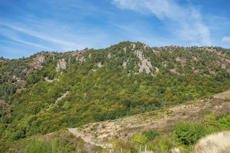
The GR70 is more than just a physical challenge; it is a journey through the historical and geological soul of France. The trail is traditionally divided into four geographical stages, each with its own unique character. The journey begins in the Velay, a region defined by its "sucs"—extinct volcanic domes that rise abruptly from fertile plateaus. Here, the soil is rich and red, and the architecture is dominated by dark volcanic stone. As walkers move south, they enter the Gévaudan, a land of vast, lonely forests and rolling hills that gained notoriety in the 18th century as the hunting ground of the "Beast of Gévaudan." This section feels remote and atmospheric, with granite hamlets tucked into hidden valleys.
The third stage marks the dramatic ascent of Mont Lozère. This is the "roof" of the trail, a massive granite whaleback that offers 360-degree views across the Massif Central and, on clear days, as far as the Alps and the Mediterranean. The landscape here is sub-alpine, characterised by "montjoies" (stone waymarkers) and vast expanses of heather and broom. Finally, the trail descends into the Cévennes National Park. The air turns warmer, the vegetation shifts to chestnut forests and holm oaks, and the architecture changes to the pale schist and limestone characteristic of the south. This final section is steeped in the history of the Camisards—Protestant rebels who fought for religious freedom in these steep, inaccessible valleys during the early 1700s.
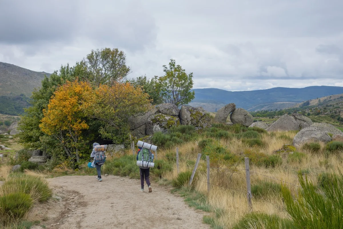
Walking the GR70 is an exercise in slow travel. While the path is well-marked with the red-and-white blazes of the Grande Randonnée network, the experience is defined by the rhythm of the villages. You will pass through medieval towns like Pradelles, listed as one of the "Most Beautiful Villages in France," and stay in "gîtes d'étape" where communal meals (table d'hôte) allow you to share stories with fellow hikers over local specialities like Aligot (cheesy mashed potatoes) and Le Puy green lentils. Whether you choose to walk with a donkey in Stevenson's honour or carry your own pack, the trail provides a rare sense of continuity, linking the literary past with a vibrant, living landscape.
History and Cultural Context
The history of the GR70 is inextricably linked to Robert Louis Stevenson, but the path itself predates him by centuries. Many sections follow ancient Roman roads, medieval trade routes, and "drailles"—the traditional paths used for transhumance, the seasonal movement of livestock between lowland and highland pastures. However, it was Stevenson’s 1878 trek that gave the route its modern identity. At the time, the Cévennes was a remote and poorly understood region of France. Stevenson’s account provided an outsider’s perspective on the local culture, the harshness of the terrain, and the lingering scars of religious conflict.
A significant layer of the trail's history is the War of the Camisards (1702–1710). Following the revocation of the Edict of Nantes, which had granted religious tolerance to Protestants, the Huguenots of the Cévennes rose in rebellion against the forces of Louis XIV. The rugged terrain of the Cévennes allowed the Camisards to wage a successful guerrilla war for years. As you walk through villages like Le Pont-de-Montvert and Cassagnas, you are walking through the heart of this resistance. Many of the local families still identify strongly with this Protestant heritage, and the trail is dotted with "temples" (Protestant churches) and memorials to the conflict.
In the late 20th century, the route was formalised as the GR70 by the Fédération Française de la Randonnée Pédestre (FFRP). It has since become one of the most popular long-distance trails in Europe. The "Association Sur le Chemin de Robert Louis Stevenson" was established to maintain the trail's heritage and support the local economy, including the unique tradition of donkey trekking. Today, the trail is a symbol of sustainable tourism, preserving the rural heritage of the Massif Central while welcoming thousands of international visitors each year.
Want more background? Read extended notes on history and cultural context → Learn more
Seasonal Highlights and Weather Reality
The GR70 traverses high-altitude plateaus and mountain passes, meaning weather conditions can be significantly more extreme than in the surrounding lowlands. The walking season typically runs from late April to October, with each month offering a different experience.
Spring (May to June): This is arguably the most beautiful time to walk. The plateaus of the Velay and the slopes of Mont Lozère are carpeted in wildflowers, including wild narcissus, orchids, and yellow broom. The days are long and generally mild, though late spring snow can occasionally occur on Mont Lozère. This is also the best time to see the "transhumance" festivals in late May, when cattle are decorated with flowers and driven to the high pastures.
Summer (July to August): These are the warmest months. While the high altitudes of the Gévaudan and Mont Lozère provide some relief from the heat, the final sections in the Cévennes can be very hot, with temperatures often exceeding 30°C. This is the peak tourist season, so accommodation must be booked well in advance. Afternoon thunderstorms are common in the mountains and can be quite intense.
Autumn (September to October): September is a favourite for many experienced hikers. The crowds thin out, the weather is stable and crisp, and the heat of the south becomes more manageable. In October, the chestnut forests of the Cévennes turn brilliant shades of gold and orange. However, walkers must be aware of the "Épisode Cévenol"—a meteorological phenomenon where warm Mediterranean air hits the mountains, causing sudden and torrential rainfall that can last for days.
Winter (November to March): The trail is not recommended for standard hiking during winter. Much of the route above 1,000 metres is covered in snow, and many gîtes and services close for the season. Cross-country skiing and snowshoeing are possible on Mont Lozère, but the full GR70 is generally impassable for hikers.
Recommended Itinerary

12-Day GR70 Stevenson Trail Itinerary
Day 1: Le Puy-en-Velay to Le Monastier-sur-Gazeille
- Distance: 19 km
- Elevation gain: 450 m
- Time: 5–6 hours
- Start at the Cathedral of Le Puy, a UNESCO World Heritage site
- Climb out of the volcanic basin with views back to the city's iconic pinnacles
- Walk through the red-soiled plateaus of the Velay
- Arrive in Le Monastier, where Stevenson spent a month preparing and where he bought Modestine
- Key Waypoints: Coubon, Goudet (castle ruins)
Day 2: Le Monastier-sur-Gazeille to Le Bouchet-Saint-Nicolas
- Distance: 23 km
- Elevation gain: 600 m
- Time: 6–7 hours
- Cross the Gazeille valley and ascend towards the volcanic plateaus
- Pass through the village of Goudet, nestled in a loop of the Loire River
- Steep climb out of the Loire valley towards the Devès plateau
- Arrive in Le Bouchet-Saint-Nicolas, famous for its volcanic lake (Lac du Bouchet) nearby
- The landscape is dominated by "sucs" and stone-walled fields
Day 3: Le Bouchet-Saint-Nicolas to Pradelles
- Distance: 21 km
- Elevation gain: 350 m
- Time: 5–6 hours
- Easy walking across the high plateau of the Velay
- Pass through Landos and Jagonas
- Enter the village of Pradelles, officially one of the "Plus Beaux Villages de France"
- Pradelles offers stunning views over the Naussac reservoir and the mountains of Lozère
- Explore the medieval streets and the high-altitude fortifications
Day 4: Pradelles to Cheylard-l’Évêque
- Distance: 21 km
- Elevation gain: 400 m
- Time: 5–6 hours
- Descend to Langogne, a bustling market town on the Allier River
- Cross from the Velay into the Gévaudan region
- Enter the dense forests of the Mercoire, where Stevenson famously got lost
- Arrive in the tiny, peaceful hamlet of Cheylard-l’Évêque
- This section feels wilder and more forested than the previous days
Day 5: Cheylard-l’Évêque to La Bastide-Puylaurent
- Distance: 26 km
- Elevation gain: 500 m
- Time: 7–8 hours
- Walk through the vast Mercoire forest, following high ridges
- Pass the ruins of the Luc Castle overlooking the Allier valley
- Descend into La Bastide-Puylaurent, a key railway junction and hiking hub
- Optional short detour to the Abbey of Notre-Dame-des-Neiges, where Stevenson stayed with the monks
- The abbey is famous for its production of wine and its hospitality to pilgrims
Day 6: La Bastide-Puylaurent to Le Bleymard
- Distance: 24 km
- Elevation gain: 650 m
- Time: 6–7 hours
- Follow the watershed between the Atlantic and the Mediterranean
- Pass through Chasseradès and its iconic railway viaduct
- Ascend through pine forests towards the base of Mont Lozère
- Arrive in Le Bleymard, the final staging point before the mountain crossing
- The architecture begins to shift from volcanic stone to granite
Day 7: Le Bleymard to Le Pont-de-Montvert (via Mont Lozère)
- Distance: 18 km
- Elevation gain: 600 m gain, 800 m descent
- Time: 6–7 hours
- The "Queen Stage" of the trail, crossing the Sommet de Finiels (1,699 m)
- Follow the "montjoies" (granite pillars) across the treeless moorland
- Spectacular 360-degree views of the Alps, the Cévennes, and the Mediterranean
- Long, steep descent into the Tarn valley
- Arrive in Le Pont-de-Montvert, a beautiful granite village where the Camisard rebellion began
Day 8: Le Pont-de-Montvert to Florac
- Distance: 28 km
- Elevation gain: 550 m
- Time: 8–9 hours
- A long but rewarding day following the ridges of the Bougès mountain
- Walk through ancient beech forests and over high granite passes
- Descend into the town of Florac, the headquarters of the Cévennes National Park
- Florac is a vibrant town with many springs, plane trees, and outdoor cafés
- The climate feels noticeably warmer and more Mediterranean here
Day 9: Florac to Cassagnas
- Distance: 16 km
- Elevation gain: 300 m
- Time: 4–5 hours
- A shorter, gentler day following the valley of the Mimente River
- Much of the path follows an old railway line (the CFD), making for easy gradients
- Pass through the "Plan de Fontmort," a site of significant Camisard battles
- Arrive in Cassagnas, a village that was a stronghold of the Protestant resistance
- The trail is surrounded by lush chestnut and pine forests
Day 10: Cassagnas to Saint-Germain-de-Calberte
- Distance: 15 km
- Elevation gain: 450 m
- Time: 4–5 hours
- Cross the Col de la Pierre Plantée, named for its prehistoric standing stone
- Enter the "Cévenne des Cévennes," the most rugged and traditional part of the range
- Descend through terraced gardens and chestnut groves
- Arrive in Saint-Germain-de-Calberte, a village perched on a ridge with stunning views
- The architecture is now predominantly schist, with slate roofs
Day 11: Saint-Germain-de-Calberte to Saint-Jean-du-Gard
- Distance: 21 km
- Elevation gain: 500 m
- Time: 6–7 hours
- The final day of Stevenson's original journey
- Cross the Col de Saint-Pierre, offering a final view back over the Cévennes mountains
- Steep descent into the Gardon valley
- Arrive in Saint-Jean-du-Gard, the "Pearl of the Cévennes"
- Visit the Maison Rouge (Museum of Cévennes Culture) to celebrate the end of the trek
Day 12: Saint-Jean-du-Gard to Alès (Optional Extension)
- Distance: 25 km
- Elevation gain: 400 m
- Time: 7–8 hours
- While Stevenson stopped at Saint-Jean, many modern hikers continue to Alès for better transport links
- Follow the Gardon river through Mediterranean scrubland (garrigue)
- Pass through the village of Anduze, famous for its pottery and the "Bambooceae" garden
- Finish in the city of Alès, the gateway to the Cévennes
- Final celebration in the city centre before departing by train
Planning and Bookings
Book Your Trip
Everything you need to plan your journey
Accommodation
Find places to stay near Le Puy-en-Velay
Flights
Search flights to Le Puy-en-Velay
Essential Preparation
The GR70 is a well-established trail, but its popularity means that planning is essential, especially regarding accommodation and transport. The trail is best walked from North to South, following the historical direction. Most hikers begin in Le Puy-en-Velay, which is easily accessible by train from Lyon or Saint-Étienne. If you are driving, you can leave your car in Le Puy and take a shuttle bus (like La Malle Postale) back from the finish line.
Physical preparation is important. While the trail does not involve technical climbing, the daily distances (averaging 20–25 km) and the cumulative elevation gain (7,500 m) require a good level of fitness. It is recommended to complete several day hikes with a weighted pack before starting. If you plan to walk with a donkey, you must book through a specialised provider (like Gentiâne or Castagnas) and attend a short training session on donkey care and psychology before setting off.
Trail Accommodation
The GR70 offers a wide range of accommodation options, catering to different budgets and preferences. Because the trail passes through many small villages, you are rarely more than a few hours from a bed.
Types of Accommodation:
- Gîtes d'étape: These are specifically designed for hikers. They offer dormitory-style sleeping (bunks) and often provide a "demi-pension" (half-board) option including dinner and breakfast. They are the most social option and the best way to meet other walkers.
- Chambres d'hôtes: French Bed and Breakfasts. These offer private rooms and a more personal experience, often in historic stone houses.
- Hotels: Available in larger towns like Le Puy, Langogne, Florac, and Saint-Jean-du-Gard.
- Camping: There are municipal and private campsites in many villages. Wild camping (bivouacking) is permitted in some areas but strictly regulated within the Cévennes National Park (only allowed between 7:00 PM and 9:00 AM, near the trail, and without fires).
Booking Requirements: During the peak months of May, June, and September, it is highly recommended to book your accommodation at least 3–4 months in advance. Many gîtes are small and fill up quickly. You can use the official Stevenson Trail website or the "Miam Miam Dodo" guidebook for a comprehensive list of contacts.
Required Gear
- Walking Boots: Sturdy, waterproof boots with good ankle support are essential. The terrain varies from soft forest paths to sharp granite rocks and loose schist.
- Rain Gear: A high-quality waterproof jacket and overtrousers. The Massif Central is prone to sudden, heavy downpours.
- Backpack: A 35–50L pack if you are carrying your own gear. Ensure it has a rain cover and a well-fitted hip belt.
- Navigation: While the trail is well-marked, you should carry the Topo-Guide (Ref 700) published by the FFRP or a reliable GPS app with offline maps (like IGN Rando).
- Sun Protection: High-factor sunscreen, a wide-brimmed hat, and sunglasses. The sun on the high plateaus can be intense.
- First Aid: A basic kit including blister plasters (Compeed), antiseptic wipes, pain relief, and any personal medications.
What to Bring
- Clothing: Use a layering system. Merino wool base layers are excellent for temperature regulation. Include a warm fleece or lightweight down jacket for cool evenings in the mountains.
- Water: At least 2 litres of carrying capacity. While there are fountains in most villages, some sections (like the crossing of Mont Lozère) have no water sources.
- Food/Snacks: High-energy snacks like nuts, dried fruit, and chocolate. You can buy picnic supplies (bread, cheese, charcuterie) in most villages each morning.
- Toiletries: Biodegradable soap and shampoo, toothbrush, and a quick-dry travel towel.
- Power: A portable power bank for your phone/GPS, as some older gîtes have limited charging points.
- Cash: Many small gîtes and village shops do not accept credit cards. Carry enough Euros to cover several days of expenses.
Permits

One of the great advantages of the GR70 is that no permits or fees are required to walk the trail itself. It is a public right-of-way open to everyone. However, there are specific regulations you must follow, particularly within the Cévennes National Park.
National Park Regulations:
- Bivouacking: If you are camping, you must follow the "bivouac" rules. This means setting up your tent after 7:00 PM and taking it down before 9:00 AM. You must stay within 50 metres of the marked GR70 trail.
- Fires: Strictly prohibited at all times due to the high risk of forest fires.
- Waste: You must carry out all rubbish. There are no bins on the trail between villages.
- Dogs: Must be kept on a lead at all times to protect wildlife and livestock.
Donkey Logistics: If you are travelling with a donkey, you do not need a permit, but you must ensure your accommodation can host the animal. Most gîtes on the Stevenson Trail are "donkey-friendly" and provide a paddock and water, but this must be confirmed at the time of booking. There is usually a small daily fee (approx. €5–€10) for the donkey's stay.
Other Activities in the Area
The regions traversed by the GR70 offer a wealth of additional experiences for those with extra time:
- Le Puy-en-Velay Sightseeing: Spend a day exploring the Notre-Dame Cathedral, the Cloister, and the spectacular Saint-Michel d'Aiguilhe chapel perched on a volcanic needle.
- Canoeing the Tarn: From Florac or Sainte-Enimie, you can rent canoes to explore the Gorges du Tarn, one of Europe's deepest and most beautiful canyons.
- The Steam Train of the Cévennes: Take the historic "Train à Vapeur des Cévennes" between Anduze and Saint-Jean-du-Gard for a nostalgic view of the mountains.
- Lentil Tasting: Visit a local farm in the Velay to learn about the "Lentille Verte du Puy," the first vegetable in France to receive AOC status.
- Chestnut Museums: Visit the Maison du Châtaignier in Saint-Germain-de-Calberte to learn about the "bread tree" that sustained the Cévenol people for centuries.
- Vulture Watching: The cliffs of the Jonte and Tarn gorges are home to reintroduced Griffon and Black vultures. Guided tours are available from Le Rozier.
Safety and Conditions
Weather Hazards: The most significant safety risk on the GR70 is the weather. On Mont Lozère, conditions can change from sunshine to thick fog and freezing rain in minutes. The "montjoies" (stone pillars) are designed to guide you in low visibility, but if the weather is severe, it is safer to wait in Le Bleymard. In the Cévennes, be wary of heatstroke in summer and flash floods during the autumn "Épisode Cévenol."
Terrain and Navigation: The trail is generally well-maintained, but some descents (notably into Le Pont-de-Montvert and Saint-Jean-du-Gard) are steep and rocky. Trekking poles are highly recommended to save your knees. While the red-and-white blazes are frequent, always carry a map or GPS, as it is easy to take a wrong turn at forest junctions.
Livestock and Wildlife: You will pass through many grazing areas. Always close gates behind you. If you encounter "Patou" (Great Pyrenees) livestock guardian dogs, do not try to pet them or run. Walk slowly and give the flock a wide berth. Ticks are present in the tall grass and ferns, especially in the Gévaudan; check your body every evening to prevent Lyme disease.
Emergency Services: The European emergency number is 112. Mobile signal is generally good in the villages but can be non-existent in the deep valleys of the Cévennes or the forests of the Mercoire. Always inform your host of your intended destination for the day.
Side Trips and Points of Interest
Abbey of Notre-Dame-des-Neiges: Located just a 2 km detour from La Bastide-Puylaurent, this Trappist monastery is where Stevenson stayed in 1878. While the original buildings burned down in 1912, the current abbey remains a place of profound peace. Visitors can attend services, buy monastic products, and walk the "Stevenson path" within the grounds.
Sommet de Finiels: The highest point of the trail (1,699 m). While the GR70 passes near the summit, a short 15-minute detour to the actual peak is essential for the best views. On a clear day, the sight of the snow-capped Alps to the east and the Mediterranean shimmer to the south is unforgettable.
The Gorges du Tarn: While the GR70 stays on the ridges above the Tarn, a side trip to the village of Sainte-Enimie (one of the most beautiful in France) is highly recommended if you have an extra two days. The canyon walls rise 500 metres above the turquoise river.
The Beast of Gévaudan Museum: In the village of Saugues (a short bus ride from the trail), you can visit a museum dedicated to the mysterious creature that terrorised the region in the 1760s. It adds a fascinating layer of folklore to your walk through the Gévaudan forests.
Leave No Trace
The GR70 passes through some of France's most fragile ecosystems, including the Cévennes National Park, a UNESCO World Heritage site for its "Mediterranean Agro-pastoral Cultural Landscape." It is our collective responsibility to preserve this heritage.
Core Principles for the Stevenson Trail:
- Respect the Silence: The Cévennes is valued for its tranquility. Avoid loud music and keep noise to a minimum, especially near villages and wildlife habitats.
- Protect the Water: Do not use soap or detergent in the rivers or streams. Even biodegradable soap can harm aquatic life in small mountain brooks.
- Stay on the Path: The "drailles" and mountain paths are susceptible to erosion. Avoid taking shortcuts on switchbacks.
- Manage Your Waste: "Pack it in, pack it out." This includes organic waste like orange peels and banana skins, which decompose very slowly in the dry Cévenol climate.
- Respect Private Property: Much of the trail passes through private farmland. Stay on the marked path and never disturb livestock or farm machinery.