GR65 - Via Podiensis: The Path of Saint James from Le Puy-en-Velay
The GR65, famously known as the Via Podiensis, is the most storied and popular of the four main medieval pilgrimage routes through France leading toward Santiago de Compostela. Stretching approximately 730 kilometres from the volcanic heights of Le Puy-en-Velay to the Basque village of Saint-Jean-Pied-de-Port at the foot of the Pyrenees, this trail is a profound journey through the heart of rural France. It is not merely a long-distance hike; it is a living museum of Romanesque architecture, a culinary expedition through the diverse terroirs of the Massif Central and Gascony, and a spiritual odyssey that has been trodden by millions over the last millennium. The route traverses a staggering variety of landscapes, from the basalt plateaux of the Velay and the granite wilderness of the Margeride to the ethereal, windswept Aubrac plateau and the limestone cliffs of the Quercy region, before finally softening into the rolling vineyards and sunflower fields of the Gers.
- Distance: 730.0 km one-way
- Duration: 4–6 weeks (typically 28 to 35 days)
- Season: April to October (Spring and Autumn are optimal)
- Accommodation: Gîtes d'étape, chambres d'hôtes, hotels, and campsites
- Highest point: Col d'Aubrac (1,340 m)
- Total Elevation Gain: Approximately 10,000 m
- Difficulty: Moderate (accessible to most fit walkers; well-marked and supported)
- Direction: East to West (Le Puy-en-Velay to Saint-Jean-Pied-de-Port)
Overview
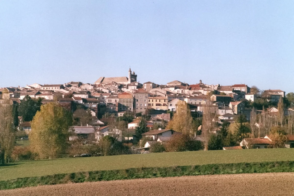
The Via Podiensis is the quintessential "Camino" experience in France. While the Spanish Camino Francés is often crowded and heavily commercialised, the GR65 offers a more balanced blend of cultural immersion, historical depth, and natural solitude. The trail begins in the spectacular setting of Le Puy-en-Velay, where the cathedral and the statue of Notre-Dame de France sit atop volcanic plugs, creating one of the most dramatic skylines in Europe. From here, the path climbs steadily into the Velay region, characterised by red volcanic soil and the cultivation of the famous green lentils of Le Puy.
As the journey progresses westward, the landscape undergoes dramatic shifts. The Margeride mountains offer dense forests and granite boulders, leading into the Aubrac—a high, treeless plateau that feels like the edge of the world. This section is often cited by pilgrims as the most evocative part of the entire route, where the silence is broken only by the clanging of cowbells and the whistling wind. The descent from the Aubrac brings walkers into the Lot Valley, home to Conques, a medieval jewel and UNESCO World Heritage site housing the relics of Saint Foy. The trail then follows the meandering Lot River, climbing onto the "causses" (limestone plateaux) of the Quercy, where dry-stone walls and ancient oak forests dominate the horizon.
The final third of the trail enters the Gers department, the heart of Gascony. Here, the ruggedness of the Massif Central gives way to a gentler, more pastoral landscape. This is the land of Armagnac, duck confit, and bastide towns—fortified medieval villages built on a grid pattern. The path remains undulating but less taxing, allowing for longer daily distances as walkers find their "pilgrim legs." The journey concludes in Saint-Jean-Pied-de-Port, the traditional gathering point for pilgrims from all over Europe before they tackle the formidable crossing of the Pyrenees into Spain. For many, the GR65 is a complete experience in itself, offering a deep dive into the "douce France" (sweet France) that remains largely untouched by modern industrialisation.
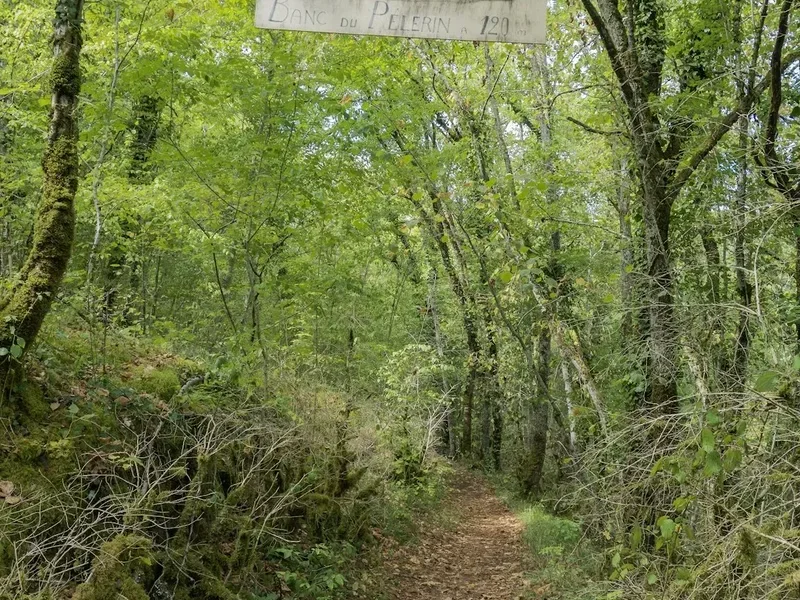
Walking the GR65 requires a moderate level of fitness. While there are no technical climbs or high-altitude mountaineering sections, the sheer cumulative distance and the daily repetition of 20 to 30 kilometres with a pack demand physical and mental resilience. The trail is exceptionally well-marked with the iconic red and white blazes of the Grande Randonnée network, making navigation straightforward even for those with limited map-reading skills. However, the true challenge—and reward—of the Via Podiensis lies in the rhythm of the road: the early morning departures, the shared meals in communal gîtes, and the slow, steady progression across a changing nation.
History and Cultural Context
The history of the Via Podiensis is inextricably linked to the cult of Saint James the Greater. According to tradition, the apostle's remains were miraculously discovered in Galicia, Spain, in the 9th century. This discovery sparked a pilgrimage movement that would define medieval European culture. The Via Podiensis specifically rose to prominence in 950 AD, when Bishop Godescalc of Le Puy-en-Velay became the first recorded non-Spanish pilgrim to make the journey to Santiago de Compostela. His successful return established Le Puy as a primary gathering point for pilgrims from Germany, Switzerland, and eastern France.
Throughout the Middle Ages, the route was a bustling artery of trade, ideas, and religious devotion. Monasteries, hospitals, and bridges were constructed along the path to support the "jacquets" (pilgrims). Many of these structures still stand today, protected as part of the UNESCO World Heritage listing "Routes of Santiago de Compostela in France." The Abbey of Sainte-Foy in Conques, the cloister of Moissac, and the bridge at Espalion are not just landmarks; they are functional remnants of a thousand-year-old infrastructure designed to facilitate human movement across the continent.
The decline of the pilgrimage began with the Reformation and the French Revolution, which saw many religious sites suppressed or destroyed. By the mid-20th century, the trail had almost been forgotten by all but local farmers. Its modern revival began in the 1970s, spearheaded by the French Hiking Federation (FFRandonnée) and a renewed interest in slow travel and spiritual seeking. Today, the GR65 attracts a diverse demographic: from devout Catholics following in the footsteps of saints to secular hikers seeking a break from the digital world. The cultural context of the trail is now a unique blend of traditional hospitality and modern outdoor recreation. The "spirit of the Camino" is alive in the "haltes vers Compostelle," where hosts continue the tradition of welcoming strangers with a warm meal and a bed, regardless of their motivations for walking.
Want more background? Read extended notes on history and cultural context → Learn more
Seasonal Highlights and Weather Reality
The timing of a GR65 trek is critical to the overall experience, as the weather varies significantly across the different regions of southern France. Because the trail crosses the Massif Central, walkers must be prepared for mountain weather even in the height of summer.
Spring (April to June): This is arguably the most beautiful time to walk. The wildflowers on the Aubrac plateau are legendary, and the Gers is a vibrant green. However, April and May can be notoriously wet, and snow is not uncommon on the higher sections of the Aubrac or the Margeride. Temperatures are generally mild, ranging from 10°C to 20°C, making for comfortable walking conditions. Early spring walkers should ensure their gear is fully waterproof.
Summer (July and August): These months bring long days and reliable sunshine, but the heat can be intense, particularly in the Lot Valley and the Gers, where temperatures frequently exceed 30°C. Shade can be scarce on the limestone plateaux. This is also the busiest time on the trail, meaning gîtes must be booked well in advance. The advantage of summer is the lively atmosphere in the villages and the numerous local festivals (fêtes) that take place along the route.
Autumn (September to October): September is many veterans' favourite month. The heat of summer has dissipated, the crowds have thinned, and the autumn colours begin to transform the forests of the Quercy and the Béarn. The harvest season in the Gers adds a festive culinary dimension to the trip. By late October, many gîtes begin to close for the season, and the days become significantly shorter and cooler.
Winter (November to March): Walking the GR65 in winter is a serious undertaking and is generally not recommended for the average hiker. Many accommodation options are closed, and the Aubrac plateau can be buried under deep snow with sub-zero temperatures and dangerous "burle" (icy winds). Only experienced winter hikers with self-sufficiency skills should attempt the route during these months.
Recommended Itinerary
The 32-Day Classic Via Podiensis Itinerary
Stage 1: The Volcanic Velay and Margeride (Days 1–5)
- Day 1: Le Puy-en-Velay to Saint-Privat-d'Allier (24 km) - Steep climb out of Le Puy, volcanic landscapes.
- Day 2: Saint-Privat-d'Allier to Saugues (19 km) - Crossing the Allier Gorge, entering the Gévaudan region.
- Day 3: Saugues to Le Domaine du Sauvage (20 km) - High granite plateau, isolated and beautiful.
- Day 4: Le Domaine du Sauvage to Aumont-Aubrac (27 km) - Entering the Lozère department, pine forests.
- Day 5: Aumont-Aubrac to Nasbinals (26 km) - The heart of the Aubrac plateau, vast open vistas.
Stage 2: The Aubrac and the Lot Valley (Days 6–10)
- Day 6: Nasbinals to Saint-Chély-d'Aubrac (17 km) - Descent from the high plateau into the forest.
- Day 7: Saint-Chély-d'Aubrac to Espalion (25 km) - Following the Lot River, medieval bridges.
- Day 8: Espalion to Golinhac (21 km) - Climbing above the Lot Valley, views of the Cantal mountains.
- Day 9: Golinhac to Conques (21 km) - Steep descent into the medieval village of Conques.
- Day 10: Conques to Decazeville (20 km) - Climbing out of the "conche" (shell) of Conques, industrial history.
Stage 3: The Quercy Limestone Plateaux (Days 11–17)
- Day 11: Decazeville to Figeac (28 km) - Entering the Lot department, beautiful stone architecture.
- Day 12: Figeac to Cajarc (31 km) - Long day on the "causse," dry-stone walls and oak scrub.
- Day 13: Cajarc to Varaire (26 km) - Deep Quercy countryside, very quiet sections.
- Day 14: Varaire to Cahors (33 km) - Approaching the historic city of Cahors and its famous bridge.
- Day 15: Cahors to Lascabanes (23 km) - Climbing out of the Lot loop, white limestone paths.
- Day 16: Lascabanes to Lauzerte (23 km) - Entering the Tarn-et-Garonne, hilltop bastide villages.
- Day 17: Lauzerte to Moissac (27 km) - Descending to the Tarn River and the famous abbey.
Stage 4: Gascony and the Gers (Days 18–25)
- Day 18: Moissac to Auvillar (21 km) - Walking along the canal, entering one of France's "most beautiful villages."
- Day 19: Auvillar to Lectoure (32 km) - Entering the Gers, rolling hills and sunflower fields.
- Day 20: Lectoure to La Romieu (19 km) - Collegiate church and the legend of the cats.
- Day 21: La Romieu to Condom (16 km) - Short day through vineyards, Armagnac country.
- Day 22: Condom to Montréal-du-Gers (17 km) - Passing the Roman villa of Séviac.
- Day 23: Montréal-du-Gers to Eauze (16 km) - Following an old railway line, easy walking.
- Day 24: Eauze to Nogaro (20 km) - More vineyards and quiet country lanes.
- Day 25: Nogaro to Aire-sur-l'Adour (28 km) - Entering the Landes department, flatter terrain.
Stage 5: Béarn and the Basque Country (Days 26–32)
- Day 26: Aire-sur-l'Adour to Arzacq-Arraziguet (33 km) - Long day entering the Pyrénées-Atlantiques.
- Day 27: Arzacq-Arraziguet to Arthez-de-Béarn (31 km) - Ridge walking with views of the Pyrenees.
- Day 28: Arthez-de-Béarn to Navarrenx (26 km) - Fortified town, crossing the Gave d'Oloron.
- Day 29: Navarrenx to Aroue (19 km) - Entering the Basque Country (Pays Basque).
- Day 30: Aroue to Ostabat (23 km) - The junction of the three great French routes.
- Day 31: Ostabat to Saint-Jean-Pied-de-Port (22 km) - Final approach to the Pyrenees.
- Day 32: Arrival in Saint-Jean-Pied-de-Port - Exploration of the citadel and preparation for Spain.
Important Notes:
- Distances are approximate and can vary based on the location of your chosen accommodation.
- Many walkers choose to break the longer days (30+ km) into two shorter stages.
- The "Miam Miam Dodo" guide is the essential resource for planning daily stops.
- Rest days are highly recommended, particularly in Figeac, Cahors, or Moissac.
- The trail is marked with red and white stripes; if you see a red/white "X", you are going the wrong way.
Planning and Bookings
Book Your Trip
Everything you need to plan your journey
Accommodation
Find places to stay near Le Puy-en-Velay
Flights
Search flights to Le Puy-en-Velay
Essential Preparation
Preparation for the GR65 involves more than just physical training. Because this is a pilgrimage route, you should obtain a "Credencial" (Pilgrim Passport) before you start. This document allows you to stay in pilgrim-specific accommodation (gîtes d'étape) and is stamped at each stop to prove your journey. You can obtain one from the Cathedral in Le Puy or via various Saint James associations online.
Fitness requirements are moderate. You should be comfortable walking 20–25 kilometres per day for several days in a row. Training should include walking with the pack you intend to carry, as the weight significantly changes the impact on your joints. Logistics-wise, Le Puy-en-Velay is well-connected by train from Lyon or Paris. Most walkers arrive a day early to explore the city and attend the morning pilgrim blessing at the cathedral (7:00 AM), which is a traditional and moving start to the journey.
Trail Accommodation
The GR65 offers a wide range of accommodation, catering to different budgets and preferences. The most common is the Gîte d'étape, which can be communal (municipal) or private.
- Gîtes d'étape: These offer dormitory-style sleeping (bunks). They usually provide a "demi-pension" (half-board) option, which includes dinner and breakfast. This is the most social way to travel. Costs range from €35 to €50 for half-board.
- Chambres d'hôtes: French Bed and Breakfasts. These offer private rooms and a more upscale experience. Expect to pay €60 to €100 per night.
- Hotels: Available in larger towns like Figeac, Cahors, and Moissac.
- Campsites: Many gîtes allow camping on their grounds for a small fee, providing access to showers and kitchens.
Booking Requirements: During the peak months of May, June, and September, it is highly recommended to book your accommodation at least 2–4 days in advance. For popular spots like Conques or the Aubrac, booking weeks in advance is wise. Many pilgrims use the "Miam Miam Dodo" guide, which lists every accommodation option along the route with phone numbers.
Required Gear
- Footwear: High-quality hiking boots or trail runners. Ensure they are well broken-in. The terrain is a mix of gravel, forest paths, and some tarmac.
- Backpack: A 35–45 litre pack is usually sufficient. Aim for a total weight (including water) of no more than 10–12% of your body weight.
- Rain Gear: A high-quality waterproof jacket and a pack cover. A trekking poncho is a popular choice among pilgrims as it covers both the walker and the pack.
- Clothing: Moisture-wicking layers. Avoid cotton. Bring at least two pairs of high-quality wool-blend hiking socks (e.g., Merino).
- Navigation: While the trail is well-marked, a guidebook (like the Topo-Guide or Miam Miam Dodo) or a GPS app (like Iphigénie or AllTrails) is essential.
- Sleeping Bag Liner: Most gîtes provide blankets or duvets, but a silk or cotton liner is required for hygiene. A full sleeping bag is only necessary if camping or walking in winter.
What to Bring
- Credencial: Your pilgrim passport (essential for gîtes).
- Water Treatment: While tap water in France is generally safe, a filter bottle or purification tablets are useful for long stretches between villages.
- First Aid: Focus on blister care (Compeed, athletic tape, needle and thread), antiseptic cream, and anti-inflammatory medication.
- Toiletries: Biodegradable soap/shampoo, a quick-dry travel towel, and sunblock.
- Power Bank: To keep your phone/GPS charged, as outlets in communal gîtes can be scarce.
- Earplugs: Essential for sleeping in dormitories.
- Snacks: While you pass through many villages, shops often close for "siesta" (12:00 PM to 2:00 PM or 3:00 PM) and on Sundays/Mondays. Always carry emergency nuts, dried fruit, or chocolate.
Permits
One of the great appeals of the GR65 is its accessibility: no official permits or fees are required to walk the trail itself. It is a public right-of-way. However, there are administrative and traditional "documents" that enhance the experience and are required for specific services.
The Credencial (Pilgrim Passport): While not a legal permit, the Credencial is mandatory if you wish to stay in the network of pilgrim gîtes (gîtes d'étape). It serves as your "ID card" as a pilgrim. You can purchase one for about €5–€10 at the Cathedral of Le Puy-en-Velay, or order one in advance from the Société Française des Amis de Saint Jacques. Each night, your host will stamp (tamponner) your book. This is also required if you intend to continue into Spain and want to receive the "Compostela" certificate in Santiago.
The Miam Miam Dodo: While not a permit, this guidebook is the "bible" of the French Camino. It is updated annually and is essential for finding accommodation, water points, and grocery stores. Most walkers consider it a mandatory part of their kit.
Fishing and Camping: If you intend to fish in the Lot or Tarn rivers, you must purchase a temporary French fishing permit (carte de pêche), available at local "Tabacs" or online. Wild camping (bivouacking) is generally tolerated in France if you set up at dusk and leave at dawn, but it is strictly forbidden in certain protected areas like the heart of the Aubrac or near historic monuments. Always ask permission if camping on private farmland.
Other Activities in the Area
The GR65 passes through some of the most culturally rich regions of France. If you have extra time, consider these activities:
- Wine Tasting in Cahors: The city is famous for its "black wine" made from Malbec grapes. Many vineyards offer tours and tastings just a short distance from the trail.
- Rocamadour Detour: From Figeac, many pilgrims take a 2–3 day detour to visit Rocamadour, a stunning vertical village built into a cliffside and a major medieval pilgrimage site in its own right.
- Canoeing the Lot River: In sections like Espalion or Cajarc, you can rent a canoe for a few hours to see the limestone cliffs from a different perspective.
- The Pech Merle Cave: Located near Cabrerets (on a variant of the GR65), this cave contains authentic prehistoric paintings that are over 25,000 years old.
- Armagnac Distilleries: In the Gers, visit a local producer to learn how France's oldest brandy is made and aged in oak barrels.
- The Cloister of Moissac: Spend a full afternoon at the Abbey of Saint-Pierre; its 12th-century cloister is considered one of the most beautiful in the world.
Safety and Conditions
Physical Health: The most common "injuries" on the GR65 are blisters and tendonitis. These are rarely life-threatening but can easily end a trip. Prevention is key: change socks if they get wet, use lubricants like "Akiléïne" or Vaseline on friction points, and don't ignore "hot spots." Tendonitis is often caused by carrying a pack that is too heavy or by increasing daily mileage too quickly. Listen to your body and take a rest day if needed.
Weather Hazards: On the Aubrac plateau, the weather can change in minutes. Fog is a genuine danger; if visibility drops, stay on the marked path. In summer, heatstroke and dehydration are risks in the Gers and the Quercy. Always carry at least 2 litres of water and wear a wide-brimmed hat. During thunderstorms, avoid high ridges and isolated trees, particularly in the Margeride.
Road Safety: While the GR65 is mostly on trails and dirt tracks, there are sections that follow or cross departmental roads. French drivers in rural areas can be fast. Always walk on the left side of the road (facing traffic) and wear reflective gear if walking at dawn or dusk.
Ticks and Pests: Ticks are prevalent in the tall grasses of the Lot and Gers and can carry Lyme disease. Check your body every evening. Bedbugs (punaises de lit) are an occasional problem in communal gîtes. To prevent bringing them home, keep your pack off the bed and consider using a permethrin spray on your gear before leaving home.
Emergency Numbers: The general emergency number in France (and the EU) is 112. For specific mountain rescue in the Massif Central or Pyrenees, this is the number to call.
Side Trips and Points of Interest
The Cele Valley Variant (GR651): Between Béduer and Cahors, many walkers choose to take the GR651 through the Célé Valley instead of the main GR65. This route is slightly longer but arguably more scenic, passing through dramatic cliffside villages like Saint-Cirq-Lapopie (voted France's favourite village) and past the Pech Merle caves. It adds about 2 days to the journey but is highly recommended for those who prefer river scenery to the dry limestone plateaux.
The Statue of Notre-Dame de France (Le Puy): Before leaving Le Puy, climb the Corneille Rock to the base of this massive red statue. It was cast from 213 cannons captured during the Siege of Sevastopol. The view from the top provides a perfect overview of the volcanic landscape you are about to traverse.
The Bridge of Pilgrims (Saint-Chély-d'Aubrac): This small stone bridge features a famous 14th-century bas-relief of a pilgrim with a staff and rosary. It is a poignant spot to stop and reflect on the millions who have crossed this same stream over the centuries.
The Romanesque Tympanum at Conques: The Abbey of Sainte-Foy features a 12th-century carving of the Last Judgement above its main door. It contains 124 characters and is one of the finest examples of Romanesque sculpture in existence. Every evening in summer, the tympanum is illuminated with a light show that explains the different scenes.
The Meridian of France: Near Saint-Privat-d'Allier, the trail crosses the "Green Meridian," an imaginary line that runs the length of France. It is marked by trees and small monuments, representing the country's commitment to environmental preservation.
Leave No Trace
The GR65 passes through a mix of public land, national parks, and private farms. Maintaining the goodwill of local farmers is essential for the trail's continued existence. Much of the route is through working agricultural land where livestock is present.
Your responsibility as a walker:
- Close all gates: This is the most important rule. Escaped livestock can cause thousands of Euros in damage and endanger the animals.
- Pack out all trash: This includes fruit peels and nut shells, which decompose slowly in the dry Quercy climate.
- Respect the silence: Many people walk the GR65 for spiritual reasons. Avoid loud music or shouting, especially when passing through small hamlets.
- Stay on the path: Short-cutting switchbacks causes erosion, particularly in the steep Allier and Lot gorges.
- Sanitation: Use public toilets in villages whenever possible. If you must go in the woods, bury waste at least 15 cm deep and 50 metres from any water source. Pack out your toilet paper.
- No Fires: Wildfires are a massive risk in southern France during the summer. Never light an open fire.