GR56: The Belgian Eifel and the High Fens
The GR56 (Grande Randonnée 56) is one of Belgium's most diverse and culturally fascinating long-distance trails, traversing the rugged landscapes of the East Cantons (Ostbelgien). Spanning approximately 157 kilometres, this route offers a profound journey through the High Fens-Eifel Nature Park, a region defined by its unique sub-alpine climate, vast peat bogs, and deep river valleys. Unlike the rolling hills of the central Ardennes, the Belgian Eifel presents a more dramatic topography, where the ancient Hercynian mountains meet the high plateau of the Hautes Fagnes. This is a landscape of transition—where the French-speaking Walloon culture blends seamlessly with the German-speaking community of Belgium, and where the history of European borders is etched into every stone marker and forest path.
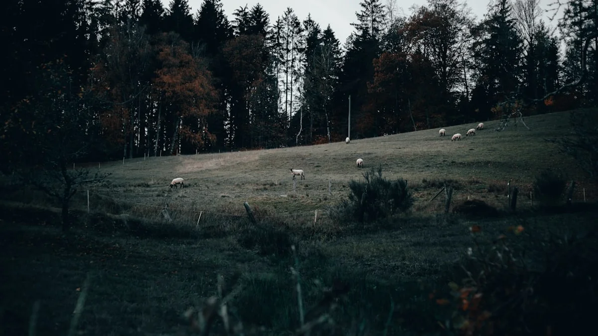
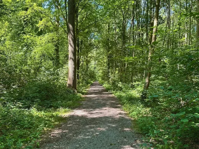
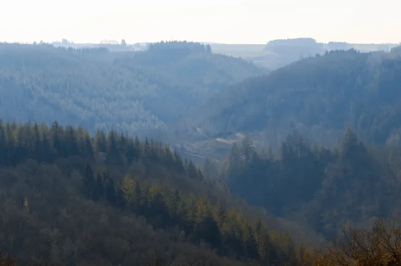
The trail is not merely a physical challenge but a sensory immersion into one of the last true wilderness areas in Western Europe. Walkers will find themselves navigating wooden boardwalks over treacherous mires, descending into the limestone-carved valleys of the Warche and Amblève rivers, and standing atop the Signal de Botrange, the highest point in the Benelux. The GR56 is a masterclass in ecological variety, transitioning from the eerie, mist-shrouded moors of the plateau to the dense, sun-dappled spruce and beech forests of the Eifel. It is a route that demands a steady pace and an appreciative eye, rewarding the traveller with medieval castle ruins, quaint timber-framed villages, and a silence that is increasingly rare in the heart of the continent.
- Distance: 157.0 km (main loop and variants)
- Duration: 7–9 days
- Season: April to October (best for flora and weather; winter offers snowshoeing opportunities)
- Accommodation: Gîtes d'étape, small hotels, and designated campsites
- Highest point: Signal de Botrange (694 m)
- Difficulty: Moderate (well-marked but requires stamina for elevation changes)
- Direction: Typically walked as a loop or point-to-point from Monschau or Eupen
Overview
The GR56 is often referred to as the "Cantons de l'Est" trail, as it circumnavigates and bisects the German-speaking region of Belgium. The route is characterised by its remarkable geological and botanical diversity. The northern section is dominated by the High Fens (Hautes Fagnes), an upland area of blanket bog that acts as a giant sponge, feeding numerous rivers that radiate across the country. Here, the trail follows narrow paths and extensive boardwalk systems designed to protect the fragile peat layers, some of which are over 10,000 years old. The landscape is open, windswept, and reminiscent of the Scottish Highlands or Scandinavian tundra, providing a sense of isolation that belies its proximity to major European cities.
As the trail moves south and east, the scenery shifts into the Belgian Eifel. The terrain becomes more undulating, with the path diving into steep-sided valleys where the water runs clear over slate beds. The architecture changes too; the grey stone houses of the Fens give way to the classic "Fachwerk" (half-timbered) style of the Eifel villages. This section of the trail is deeply forested, providing cool canopy cover during the summer months. The elevation gain, totalling approximately 3,500 metres over the full distance, is achieved through a series of "short, sharp shocks"—steep climbs out of river valleys followed by long, gentle traverses across high ridges with panoramic views into Germany and the southern Ardennes.
Logistically, the GR56 is exceptionally well-serviced by the Sentiers de Grande Randonnée (GR) network. The iconic red-and-white blazes are frequent and reliable, though the complexity of the landscape means a map or GPS is essential. The trail passes through several significant towns, including Eupen, Malmedy, and Sankt Vith, each offering a distinct cultural experience and excellent Belgian gastronomy. Whether you are crossing the "Noir Flohay" (a ghostly forest of dead trees in the Fens) or exploring the ruins of Reinhardstein Castle, the GR56 provides a constant stream of historical and natural landmarks that keep the journey engaging from start to finish.
History and Cultural Context
The history of the GR56 is inextricably linked to the complex political evolution of the "New Belgium" territories. Following the Treaty of Versailles in 1919, the districts of Eupen and Malmedy were transferred from the German Empire to Belgium as part of war reparations. This created a unique cultural enclave where German remains the primary language, yet the identity is firmly Belgian. As you walk the GR56, you will encounter old border stones (Borne Frontière) marked with "P" for Prussia and "B" for Belgium, silent witnesses to the shifting frontiers of the 19th and 20th centuries. The trail often follows these historic boundary lines, offering a literal walk through the annals of European diplomacy.
The High Fens plateau has its own human history, primarily centred on peat harvesting. For centuries, local villagers braved the treacherous bogs to cut peat for fuel, a practice that only ceased in the mid-20th century. The "Baraque Michel," a famous inn and landmark on the trail, was established in 1811 by a lost traveller who vowed to build a refuge for others caught in the Fens' notorious mists. It served as a rescue station for decades, with a bell rung during heavy fog to guide the wayward to safety. This spirit of hospitality remains a cornerstone of the region today, with the GR56 passing numerous mountain huts and traditional inns that have welcomed travellers for generations.
During World War II, this region was the site of the devastating Battle of the Bulge. The dense forests of the Eifel and the open expanses of the Fens saw some of the most intense combat of the winter of 1944-1945. Many sections of the trail pass near memorials and former foxholes, particularly around Malmedy and Sankt Vith. Walking the GR56 today is a peaceful experience, but the scars of the past—both political and military—are visible to those who know where to look. The trail serves as a bridge between these histories, celebrating the natural beauty of a land that was once a contested frontier.
Want more background? Read extended notes on history and cultural context → Learn more
Seasonal Highlights and Weather Reality
The GR56 is a year-round trail, but the experience changes dramatically with the seasons. Due to its elevation and the "sponge" effect of the High Fens, the region is significantly cooler and wetter than the rest of Belgium. Rainfall is frequent, and the plateau can be shrouded in fog even when the surrounding valleys are clear.
Spring (April to June): This is perhaps the most beautiful time to visit. The High Fens erupt in colour as the cotton grass blooms, covering the moors in white tufts. In the valleys, wild daffodils (Narcissus pseudonarcissus) carpet the meadows, particularly in the Holzwarche valley. Temperatures are mild, ranging from 8°C to 18°C, though nights remain crisp. This is also the best time for birdwatching, as migratory species return to the bogs.
Summer (July to August): The most stable weather, with temperatures averaging 20°C to 25°C. The forests provide essential shade, and the long daylight hours allow for flexible trekking schedules. However, this is also the peak season for tourism in towns like Monschau and Malmedy, so accommodation should be booked well in advance. Be aware that during exceptionally dry summers, certain areas of the High Fens may be closed to hikers due to fire risk (indicated by red flags).
Autumn (September to October): The beech and oak forests of the Eifel turn brilliant shades of gold and copper. The "deer rut" (mating season) occurs in late September, and the haunting bellows of stags can often be heard from the trail. The weather becomes more unpredictable, with increased rainfall and the first morning frosts appearing on the plateau by late October.
Winter (November to March): The GR56 transforms into a winter wonderland. The High Fens often receive significant snowfall, and sections of the trail are used for cross-country skiing. Walking during this time requires specialized gear (snowshoes or spikes) and advanced navigation skills, as snow can obscure the red-and-white markers. Many smaller gîtes may close during the deepest winter months.
Recommended Itinerary
8-Day GR56: The Belgian Eifel Loop
Day 1: Monschau (Germany) to Eupen (Belgium)
- Distance: 25 km
- Elevation gain: 450 m
- Time: 6–7 hours
- Start in the historic pearl of the Eifel, Monschau, with its half-timbered houses
- Cross the border into Belgium via the Hill Valley
- Enter the High Fens-Eifel Nature Park, following the Hill river upstream
- Traverse the first sections of the high plateau moors
- Descend into Eupen, the capital of the German-speaking community
- Key Waypoints: Monschau Old Town, Hill Valley, Weser Dam (Barrage de la Vesdre)
Day 2: Eupen to Signal de Botrange
- Distance: 20 km
- Elevation gain: 550 m
- Time: 5–6 hours
- A steady climb from the Vesdre valley back onto the high plateau
- Pass through the Hertogenwald (Duke's Forest), a vast expanse of ancient woodland
- Reach the "Baraque Michel," one of the highest and most historic points in Belgium
- Finish at Signal de Botrange, the highest point in the Benelux (694 m)
- Key Waypoints: Hertogenwald, Ghaster, Baraque Michel, Botrange Tower
Day 3: Signal de Botrange to Malmedy
- Distance: 22 km
- Elevation gain: 300 m (mostly descent)
- Time: 6 hours
- Walk across the heart of the High Fens on extensive wooden boardwalks
- Pass the "Noir Flohay," a stand of skeletal trees killed by fire and bog acidity
- Follow the Bayehon stream, featuring the highest waterfall in the region
- Descend into the vibrant town of Malmedy
- Key Waypoints: Grande Fagne, Cascade du Bayehon, Malmedy Cathedral
Day 4: Malmedy to Robertville
- Distance: 18 km
- Elevation gain: 400 m
- Time: 5 hours
- Follow the Warche river valley, one of the most scenic sections of the GR56
- Climb to the spectacular Reinhardstein Castle, perched on a rocky promontory
- Walk along the shores of Lake Robertville
- Key Waypoints: Warche Valley, Reinhardstein Castle, Robertville Dam
Day 5: Robertville to Bütgenbach
- Distance: 16 km
- Elevation gain: 250 m
- Time: 4–5 hours
- A gentler day following the course of the Warche upstream
- Pass through traditional Eifel villages with stone-walled gardens
- Arrive at Lake Bütgenbach, a popular spot for water sports and relaxation
- Key Waypoints: Weywertz, Bütgenbach Viaduct, Lake Bütgenbach
Day 6: Bütgenbach to Losheimergraben
- Distance: 20 km
- Elevation gain: 350 m
- Time: 5–6 hours
- Enter the "Our" river catchment area
- Follow the Vennbahn (historic railway line) for short sections
- Traverse dense spruce plantations and open meadows near the German border
- Key Waypoints: Büllingen, Honsfeld, Losheimergraben (border crossing)
Day 7: Losheimergraben to Schönberg
- Distance: 22 km
- Elevation gain: 450 m
- Time: 6–7 hours
- Follow the Our river as it carves a deep, winding valley
- This section is remote and quiet, with few villages
- Excellent opportunities for spotting wildlife like black storks and red deer
- Key Waypoints: Our Valley, Manderfeld, Schönberg Bridge
Day 8: Schönberg to Sankt Vith
- Distance: 14 km
- Elevation gain: 300 m
- Time: 4 hours
- A final climb out of the Our valley onto the ridges overlooking Sankt Vith
- Pass through the "Wolfsbusch" forest
- Finish in the historic town of Sankt Vith, largely rebuilt after WWII
- Key Waypoints: Meyerode, Sankt Vith Büchel Tower
Important Notes:
- The route can be extended by taking the "Variante Sud" towards Ouren
- Public transport (TEC buses) connects most major towns on the route
- Boardwalks in the High Fens can be slippery when wet; use caution
- Check for "Zone C" closures in the Fens (breeding season/fire risk)
Planning and Bookings
Book Your Trip
Everything you need to plan your journey
Accommodation
Find places to stay near Liège
Flights
Search flights to Liège
Essential Preparation
The GR56 requires a moderate level of fitness. While there are no high-altitude peaks, the cumulative elevation gain and the often-soggy terrain of the High Fens can be taxing on the legs. It is essential to break in your boots before attempting the full loop. Logistics are relatively straightforward, but because the trail passes through the German-speaking community, knowing a few basic phrases in German (and French for the Malmedy area) is highly beneficial and appreciated by locals.
Liège is the primary gateway city. From Liège-Guillemins station, you can take a train to Verviers and then a bus (Line 395) to Monschau or Eupen. If driving, parking is available in Eupen or at the various "Signal de Botrange" parking lots, though multi-day parking should be coordinated with local tourism offices. It is highly recommended to download the GPX tracks from the "Sentiers de Grande Randonnée" website, as some intersections in the forest can be confusing.
Trail Accommodation
Accommodation on the GR56 ranges from rustic to refined. Because the trail passes through several established towns, you have the luxury of choice, but booking is essential during the summer and autumn months.
Types of Accommodation:
- Gîtes d'étape: These are hiker-friendly hostels often located in historic buildings. They provide dormitory-style beds and communal kitchens. (e.g., Gîte d'Eupen, Gîte de Malmedy).
- Hotels and B&Bs: Plentiful in Monschau, Eupen, Malmedy, and Sankt Vith. Many offer "Wanderfreundlich" (hiker-friendly) services, including luggage transfer and packed lunches.
- Campsites: There are several commercial campsites near Robertville and Bütgenbach. Note that wild camping is strictly prohibited in Belgium, especially within the High Fens Nature Park.
- Bivouac Sites: A few designated legal bivouac zones exist near the trail (e.g., near the Soor valley), but these have strict rules: one night only, no fires, and limited capacity.
Facilities and Costs:
- Gîtes typically cost €25–€40 per night for a bunk.
- Mid-range hotels average €80–€120 for a double room.
- Most towns have supermarkets (Delhaize, Carrefour, or Aldi) for restocking supplies.
- Luggage transfer services are available through local providers like "Ostbelgien Wandern."
Required Gear
- Footwear: Waterproof hiking boots with good ankle support. The High Fens are notoriously boggy; even on boardwalks, you will encounter mud.
- Rain Gear: A high-quality waterproof jacket and overtrousers. The region receives some of the highest rainfall in Belgium.
- Navigation: Topographic maps (IGN 1:25,000 scale) or a reliable GPS device with offline maps. Do not rely solely on mobile signal, which can be spotty in deep valleys.
- Backpack: 35–50L depending on whether you are staying in gîtes or carrying camping gear. Ensure it has a waterproof cover.
- Clothing: Layering is key. Even in summer, the plateau can be windy and cold. Merino wool base layers are ideal.
- Safety: A basic first aid kit, including blister plasters (Compeed) and a space blanket.
What to Bring
- Water Treatment: While tap water in towns is safe, if you plan to take water from streams, a filter (like a Sawyer Squeeze) or purification tablets are necessary due to agricultural runoff in some areas.
- Food: Carry at least one day's worth of emergency rations. While towns are frequent, some sections (like the Our valley) have very few services.
- Power: A portable power bank for your phone/GPS.
- Sun Protection: Sunscreen and a hat; the open moors of the Fens offer no shade.
- Insect Repellent: Ticks are common in the tall grasses and forests of the Eifel; check yourself daily.
- Cash: While cards are widely accepted, some smaller gîtes and rural cafés may only take cash.
Permits
No formal permits or fees are required to walk the GR56. However, the High Fens (Hautes Fagnes) section is a strictly regulated Nature Reserve, and walkers must adhere to specific zoning laws to protect the environment.
High Fens Zoning System:
- Zone A: Fully accessible to the public on marked paths.
- Zone B: Accessible only on marked paths and boardwalks. No dogs allowed, even on a lead.
- Zone C: Accessible only with a certified nature guide. These areas are often closed to the public to protect sensitive species.
- Zone D: Completely closed to the public (scientific research zones).
Temporary Closures: During periods of high fire risk, a "Red Flag" system is implemented. If you see red flags flying at the entrance to the Fens or at major trailheads, it means the moors are closed to all hikers. This usually happens during dry spells in spring or summer. Additionally, certain sections may be closed during the hunting season (October to December). Always check the "Ostbelgien" tourism website or the "Hautes Fagnes" official site for real-time alerts before starting your day's walk.
Other Activities in the Area
The East Cantons offer a wealth of experiences beyond the hiking trail:
- Vennbahn Cycle Path: One of Europe's longest rail-trails, this 125 km paved path follows the old railway line through three countries. It is perfect for a recovery day on a rented e-bike.
- Reinhardstein Castle: Take a guided tour of this 14th-century fortress. It is the highest castle in Belgium and contains an impressive collection of armour, tapestries, and period furniture.
- Spa-Francorchamps Circuit: Located near Malmedy, this is one of the world's most famous Formula 1 tracks. Even on non-race days, you can often visit the museum or take a guided tour of the facilities.
- Chocolate Tasting in Eupen: Visit the Jacques Chocolate Museum and factory for a deep dive into Belgium's most famous export.
- Monschau Glassworks: Watch traditional glassblowing demonstrations in the historic centre of Monschau, just across the German border.
- Lake Bütgenbach: In summer, the lake offers kayaking, windsurfing, and a dedicated swimming area with a sandy beach.
Safety and Conditions
Weather Hazards: The most significant safety concern on the GR56 is the weather. The High Fens plateau is notorious for sudden, thick fog that can reduce visibility to a few metres. If you lose the trail in the fog, do not wander into the bog; stay on the last known path or boardwalk. Hypothermia is a risk even in shoulder seasons if you are caught in a cold rain without proper gear.
Terrain: The boardwalks (caillebotis) can be extremely slippery when wet or icy. Many are old and may have loose planks. Walk with care and consider using trekking poles for balance. In the river valleys, paths can be narrow and rocky, requiring sure-footedness, especially after heavy rain when mud makes the slopes treacherous.
Wildlife and Pests:
- Ticks: The region is a known hotspot for Lyme disease. Wear long trousers, use repellent, and perform a thorough tick check every evening.
- Wild Boar: While generally shy, wild boars are common in the Eifel forests. If you encounter one, give it a wide berth and do not approach, especially if piglets are present.
- Adders: The European adder is present in the Fens. They are venomous but rarely bite unless stepped on or provoked. Watch where you place your hands and feet in rocky or heathland areas.
Emergency Services: The European emergency number is 112. Be prepared to give your coordinates (GPS) as many forest locations do not have clear road access. Most major trail intersections have numbered markers that can help rescuers locate you.
Side Trips and Points of Interest
Cascade du Bayehon: Located near Longfaye, this is the highest waterfall in Belgium (though modest by global standards at 9 metres). What makes it unique is the reddish-brown colour of the water, caused by the high tannin and iron content of the peat bogs it drains. It is a perfect spot for a mid-day break on Day 3.
The "Noir Flohay": This is one of the most atmospheric spots on the GR56. It is a stand of dead Scots pines in the middle of the High Fens. The trees were killed by a combination of a massive fire in the 1940s and the subsequent rise of the water table. The bleached, skeletal remains of the trees against the open moorland create a haunting, prehistoric landscape.
Signal de Botrange Tower: While the natural highest point is 694 metres, a stone mound (the Baltia hill) was built in 1923 to bring the elevation to exactly 700 metres. Climbing the stairs of the nearby tower provides a view that, on clear days, extends as far as the Eifel mountains in Germany and the Ardennes peaks to the south.
The Our Valley: The southern section of the GR56 follows the Our river, which forms the border between Belgium and Germany. This valley is much deeper and more secluded than the northern sections. The path often clings to the hillside, offering "balcony" views of the winding river below. It is the best place on the trail to see rare flora like the wild blue lupine.
Leave No Trace
The High Fens-Eifel Nature Park is a fragile ecosystem that relies on the responsibility of its visitors. The peat bogs are particularly sensitive; a single footstep off the boardwalk can destroy rare mosses that have taken decades to grow and can leave a scar in the bog that lasts for years.
Core Principles for the GR56:
- Stay on the Path: This is non-negotiable in the High Fens. The boardwalks are there for your safety and the bog's protection.
- No Fires: The peat soil is highly flammable and can smoulder underground for weeks if ignited. Fires and charcoal BBQs are strictly forbidden.
- Manage Your Waste: There are no bins on the trail. Pack out all rubbish, including organic waste like orange peels or apple cores, which do not decompose quickly in the acidic bog environment.
- Respect the Silence: The High Fens is a sanctuary for rare birds like the Black Grouse. Keep noise to a minimum to avoid disturbing nesting sites.
- Dogs: In many parts of the High Fens (Zone B), dogs are strictly prohibited to protect wildlife. In other areas, they must be kept on a short lead at all times.