GR53: The Red Sandstone Way of the Northern Vosges
The GR53 is one of France's most enchanting long-distance trails, traversing the heart of the Parc Naturel Régional des Vosges du Nord. Stretching approximately 192 kilometres from the historic gateway of Wissembourg to the mountainous horizon of Schirmeck, this trail offers a profound journey through a landscape defined by its unique geology and turbulent border history. Unlike the more rugged high peaks of the southern Vosges, the GR53 winds through a world of deep, silent forests, dramatic "Buntsandstein" (red sandstone) cliffs, and an extraordinary density of medieval castle ruins that cling to rocky outcrops like stone sentinels. This is a trail where nature and history are inextricably linked, leading walkers through a UNESCO-recognised Biosphere Reserve that serves as a vital corridor for European wildlife, including the elusive lynx and the peregrine falcon.
- Distance: 192.0 km
- Duration: 8–12 days
- Elevation Gain: 6,500 m
- Difficulty: Moderate
- Best Time: June to September
- Closest City: Strasbourg
- Trailhead: Wissembourg, Bas-Rhin, France
- End Point: Schirmeck, Bas-Rhin, France
Overview
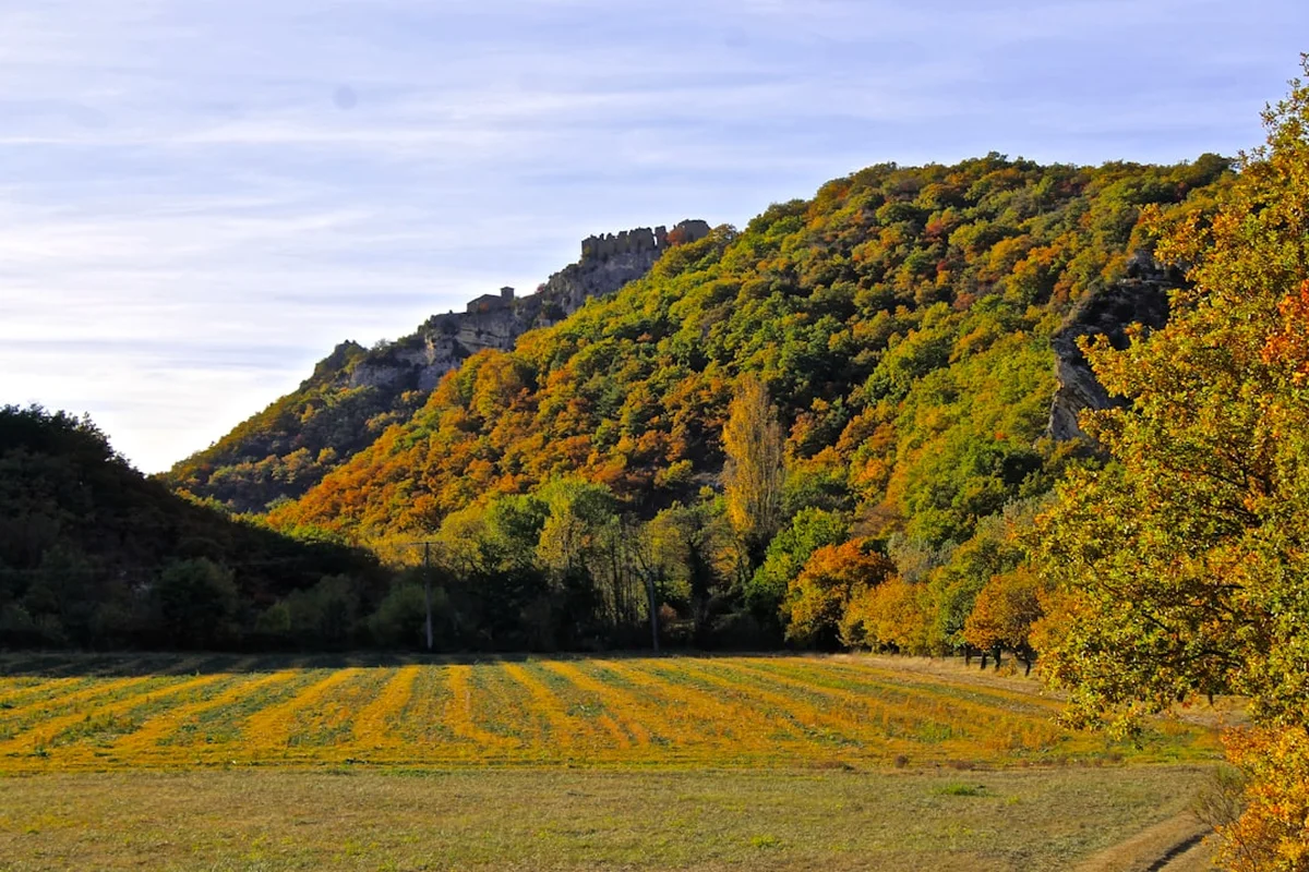
The GR53, often referred to as the "Sentier des Vosges du Nord," is a masterclass in atmospheric hiking. The trail begins in the picturesque town of Wissembourg, right on the border with Germany, and immediately plunges the walker into a landscape of rolling hills and dense woodland. The defining characteristic of the GR53 is the presence of the "Grès Rose" or pink sandstone. This geological feature creates a landscape of striking contrasts: emerald green forests of beech and pine punctuated by towering, rust-coloured rock formations. Over centuries, these natural fortresses were augmented by human hands, resulting in a trail that passes more than a dozen medieval castles, each with its own legend and architectural character.
The terrain is best described as "moderate but persistent." While the GR53 does not reach the soaring alpine heights of the Alps or the Pyrenees, its constant undulations—climbing from valley floors to sandstone ridges and back again—accumulate a significant total elevation gain of 6,500 metres. The paths are generally well-maintained and wide, often following ancient forest tracks or narrow, winding single-tracks through the undergrowth. The walking is rhythmic and meditative, occasionally broken by steep, heart-pumping ascents to reach a panoramic viewpoint or a ruined keep. The highest point of the journey is the Donon massif, a sacred mountain since antiquity, which offers a 360-degree view of the Rhine plain and the distant Black Forest.
Culturally, the GR53 is a journey through the heart of Alsace. Walkers will pass through timber-framed villages where the scent of woodsmoke and traditional Alsatian cuisine fills the air. The region's complex history as a borderland between France and Germany is visible everywhere, from the medieval fortifications to the concrete bunkers of the Maginot Line. This is a trail for those who appreciate the quiet beauty of the forest, the mystery of ancient ruins, and the comfort of a warm "Winstub" (wine lounge) at the end of a long day's trek. It is a route that rewards the patient observer, offering glimpses of deer in the early morning mist and the intricate textures of moss-covered sandstone in the afternoon light.
History and Cultural Context
The history of the GR53 is a tapestry of medieval ambition, industrial heritage, and the scars of modern warfare. The Northern Vosges have served as a natural frontier for millennia. During the Middle Ages, the region was a patchwork of small lordships and ecclesiastical territories. The sheer number of castles along the route—such as Fleckenstein, Hohenbourg, and Lichtenberg—testifies to the strategic importance of these hills. These fortresses were designed to control the trade routes passing through the narrow valleys and to project power across the Rhine plain. Walking the GR53 is, in many ways, a tour of the rise and fall of the Holy Roman Empire's influence in the region.
In the 19th century, the Northern Vosges became a centre for the burgeoning Romantic movement. Artists and poets were drawn to the "sublime" nature of the ruined castles and the dark, brooding forests. This period also saw the birth of organised hiking in the region. The "Club Vosgien" (Vogesenclub), founded in 1872, is one of the oldest hiking organisations in the world. It was these early pioneers who first mapped and marked the trails that would eventually become the GR53. Their iconic marking system—using simple geometric shapes like the red rectangle for the GR53—remains the gold standard for trail navigation in France today.
The 20th century brought darker chapters to the landscape. The GR53 crosses several sections of the Maginot Line, the massive system of fortifications built by France in the 1930s to deter German invasion. Sites like the Four-à-Chaux fortress near Lembach offer a chilling look at the industrialisation of warfare. The forests themselves still hold the remains of trenches and foxholes from the fierce fighting that occurred during the liberation of Alsace in the winter of 1944-1945. Today, the trail serves as a path of peace and reconciliation, part of the larger European network of trails that connect nations. The UNESCO Biosphere Reserve status, granted in 1989, recognises the region's commitment to preserving both its natural heritage and its unique cultural identity, where French and Germanic influences blend seamlessly in dialect, architecture, and gastronomy.
Want more background? Read extended notes on history and cultural context → Learn more
Seasonal Highlights and Weather Reality
The GR53 is a four-season trail, but the experience changes dramatically with the turning of the year. The continental climate of Alsace means that summers can be hot and humid, while winters are often cold with significant snowfall in the higher reaches.
Spring (April to May): This is a season of rebirth in the Northern Vosges. The beech forests erupt in a vibrant, translucent green, and wildflowers like wild garlic and anemones carpet the forest floor. Temperatures are generally mild (10°C to 18°C), making for comfortable walking, though spring showers are common. This is the best time to see the waterfalls at their most active and to enjoy the trail before the summer heat arrives.
Summer (June to August): The peak hiking season. The canopy of the vast forests provides welcome shade from the sun, which can push temperatures in the valleys up to 30°C. The long daylight hours allow for relaxed days with plenty of time for exploring castle ruins. However, this is also the season of afternoon thunderstorms, which can be intense. It is essential to carry plenty of water, as some of the sandstone ridges can be surprisingly dry.
Autumn (September to October): Many regular hikers consider this the "golden season" for the GR53. The beech and oak forests turn into a riot of gold, orange, and deep red, contrasting beautifully with the pink sandstone. The air is crisp and clear, often providing the best visibility for distant views of the Black Forest or the Swiss Alps. September is also the start of the wine harvest in the nearby Alsatian vineyards, adding a festive atmosphere to the villages.
Winter (November to March): The trail becomes a quiet, monochromatic world. Snow is common, especially on the sections above 500 metres. While the trail remains open, some of the steeper sandstone sections can become icy and treacherous. Many gîtes and smaller hotels close during the mid-winter months, so careful planning is required. For the experienced hiker, a snow-covered trek to a ruined castle is a magical, solitary experience.
Recommended Itinerary
10-Day GR53 Itinerary: Wissembourg to Schirmeck
Day 1: Wissembourg to Climbach
- Distance: 16 km
- Elevation gain: 450 m
- Time: 4–5 hours
- Start in the medieval centre of Wissembourg, following the red rectangle markings
- Initial climb through vineyards with views back over the Rhine plain
- Enter the deep forest of the Northern Vosges
- Pass the Col du Pigeonnier (432 m)
- Arrive in the quiet village of Climbach, known for its historic chapel ruins
Day 2: Climbach to Obersteinbach
- Distance: 19 km
- Elevation gain: 600 m
- Time: 5–6 hours
- A day defined by the first major castle ruins
- Pass the Petit-Arnsberg castle, carved directly into the sandstone
- Descend into the valley of the Steinbach
- Climb to the ruins of Wasigenstein, famous in Germanic mythology (the Waltharius legend)
- Arrive in Obersteinbach, a quintessential hiking village with excellent local inns
Day 3: Obersteinbach to Niederbronn-les-Bains
- Distance: 22 km
- Elevation gain: 750 m
- Time: 6–7 hours
- The "Castle Marathon" day
- Visit the spectacular Château de Fleckenstein (restored and highly impressive)
- Pass the ruins of Hohenbourg and Loewenstein on the same ridge
- Cross the border briefly into Germany at the Wegelnburg ruins
- Long descent into the spa town of Niederbronn-les-Bains
Day 4: Niederbronn-les-Bains to Lichtenberg
- Distance: 20 km
- Elevation gain: 650 m
- Time: 5–6 hours
- Climb to the Grand Wintersberg (581 m), the highest point in the Northern Vosges, with an observation tower
- Traverse high sandstone ridges with views of the "Pays de Bitche"
- Pass through the village of Rothbach, famous for its sandstone quarries
- Arrive at the imposing fortress of Lichtenberg, which dominates the skyline
Day 5: Lichtenberg to La Petite-Pierre
- Distance: 22 km
- Elevation gain: 500 m
- Time: 6–7 hours
- A gentler day through rolling forest terrain
- Pass through the "Forêt de Hanau"
- Enter the heart of the UNESCO Biosphere Reserve
- Arrive in La Petite-Pierre (Lützelstein), a fortified village perched on a narrow sandstone spur
- The village is the headquarters of the Nature Park and hosts a famous jazz festival in summer
Day 6: La Petite-Pierre to Saverne
- Distance: 26 km
- Elevation gain: 700 m
- Time: 7–8 hours
- A long but rewarding day following the "Crête des Vosges"
- Pass the "Rocher de l'Indien" (Indian Rock), a unique sandstone formation
- Visit the ruins of Greifenstein overlooking the Zorn valley
- Descend into Saverne, known as the "Eye of Alsace," featuring the massive Rohan Palace and the Marne-Rhine Canal
Day 7: Saverne to Wangenbourg-Engenthal
- Distance: 22 km
- Elevation gain: 800 m
- Time: 6–7 hours
- Transition from the Northern Vosges to the Central Vosges
- Climb to the Haut-Barr castle, known as the "Eye of Alsace" for its strategic views
- Pass the twin ruins of Geroldseck
- Follow the ridge to the "Table des Géants" (Giants' Table) megalithic site
- Arrive in the mountain resort of Wangenbourg, dominated by its 13th-century keep
Day 8: Wangenbourg-Engenthal to Urmatt
- Distance: 20 km
- Elevation gain: 600 m
- Time: 5–6 hours
- Deep forest immersion in the Bruche valley watershed
- Pass the "Schneeberg" (892 m), offering views toward the High Vosges
- Descend through mossy ravines and past small mountain streams
- Arrive in Urmatt, a village with a train station providing easy access back to Strasbourg if needed
Day 9: Urmatt to Schirmeck
- Distance: 15 km
- Elevation gain: 550 m
- Time: 4–5 hours
- Climb toward the Donon massif
- Pass the "Porte de Pierre" (Stone Gate), a natural sandstone archway
- Descend into the town of Schirmeck
- Visit the Memorial Alsace-Moselle for a deep dive into the region's complex 20th-century history
Day 10: Schirmeck to Le Donon (Summit and Return)
- Distance: 10 km
- Elevation gain: 600 m
- Time: 4 hours
- The final ascent to the sacred summit of Le Donon (1,009 m)
- Explore the Roman-style temple built in the 19th century on the site of ancient shrines
- Final panoramic views of the entire GR53 route to the north
- Return to Schirmeck for the train back to Strasbourg
Important Notes:
- The trail is marked with a solid red rectangle (the symbol of the GR53)
- Water sources are infrequent on the sandstone ridges; carry at least 2 litres
- Many castles have steep, unprotected drops; exercise caution when exploring
- The trail can be shortened by using the excellent regional train (TER) network from towns like Niederbronn, Saverne, and Schirmeck
Planning and Bookings
Book Your Trip
Everything you need to plan your journey
Accommodation
Find places to stay near Strasbourg
Flights
Search flights to Strasbourg
Essential Preparation
The GR53 is a well-established route, but it requires thoughtful preparation, particularly regarding logistics and fitness. While the trail is not technically difficult, the cumulative elevation gain over 10 days requires a good level of cardiovascular fitness and leg strength. It is highly recommended to undertake several day hikes with a weighted pack before attempting the full route.
Logistically, Strasbourg is the primary hub. From Strasbourg, regional trains (TER Grand Est) run frequently to Wissembourg (the start) and from Schirmeck (the end). If you are driving, it is often best to leave your car in Strasbourg and use the train to reach the trailheads. The "Club Vosgien" maps (IGN TOP25 series) are essential; specifically, maps 3814 ET, 3714 ET, and 3715 OT cover the majority of the route. These can be purchased at outdoor shops in Strasbourg or at the tourist office in Wissembourg.
Trail Accommodation
Accommodation on the GR53 is varied, ranging from simple mountain huts to comfortable village hotels. Unlike the high-altitude "Refuges" in the Alps, most accommodation on the GR53 is located in or near villages.
Types of Accommodation:
- Gîtes d'étape: Simple, dormitory-style accommodation designed specifically for hikers. They usually provide a bed, access to a kitchen, and sometimes a communal meal (demi-pension).
- Hotels and Auberges: Found in almost every village. These offer private rooms and often feature excellent local restaurants.
- Club Vosgien Refuges: These are often basic shelters or managed huts. Some are only open on weekends or during the summer season. Check the Club Vosgien website for specific opening times and booking requirements.
- Camping: There are several organised campsites along the route (e.g., in Niederbronn, Saverne, and Wangenbourg). Wild camping (bivouacking) is generally tolerated between 7:00 PM and 9:00 AM, provided you are not in a protected "Zone de Silence" or near a historic monument, but it is strictly regulated within the heart of the Nature Park.
Booking Requirements: During the peak months of July and August, and during the autumn foliage season in October, it is essential to book your accommodation at least 2–4 weeks in advance. Many gîtes are small and fill up quickly with groups.
Required Gear
- Hiking Boots: Mid-cut boots with a good lugged sole (Vibram or similar) are recommended. The sandstone can be slippery when wet, and the forest tracks often have hidden roots.
- Rain Gear: A high-quality waterproof jacket and overtrousers. The Vosges can experience sudden, heavy downpours.
- Backpack: A 35–50 litre pack is usually sufficient for a hut-to-hut trip. Ensure it has a fitted rain cover.
- Navigation: A compass and the relevant IGN TOP25 maps. While the trail is well-marked, forest intersections can be confusing. A GPS or offline map app (like Outdooractive or Komoot) is a valuable backup.
- First Aid: Include blister plasters (Compeed), antiseptic wipes, and a tick removal tool (ticks are prevalent in the Vosges forests).
- Sun Protection: Even under the canopy, the sun can be strong on the ridges. Bring a hat, sunglasses, and SPF 30+ sunscreen.
What to Bring
- Water Treatment: While you will pass through villages, a lightweight filter (like a Sawyer Squeeze) or purification tablets are useful for emergency refills from forest springs.
- Food: Carry enough snacks (nuts, dried fruit, energy bars) for each day. Most villages have a "Boulangerie" where you can buy fresh bread and pastries for lunch. Note that many small village shops close on Sunday and Monday.
- Clothing: Use a layering system. Merino wool base layers are excellent for moisture management and odour control. Include a lightweight fleece or "puffy" jacket for cool evenings.
- Toiletries: Biodegradable soap and a quick-dry travel towel. If staying in gîtes, bring your own earplugs—dorms can be noisy.
- Power: A portable power bank for your phone/GPS. While hotels have sockets, gîtes may have limited charging points.
- Cash: Many smaller auberges and gîtes in the mountains do not accept credit cards. Carry enough Euros to cover several days of food and lodging.
Permits
One of the great joys of hiking the GR53 is the lack of bureaucratic hurdles. No permits are required to walk the trail, and there are no entry fees for the Parc Naturel Régional des Vosges du Nord. The trail is a public right-of-way, open to everyone year-round.
Key Considerations:
- Group Size: While there is no official limit, groups larger than 10 people should contact gîtes well in advance to ensure they can be accommodated.
- Hunting Season: From late September to February, hunting (la chasse) is active in the Vosges. During this time, it is vital to stay on the marked trails and wear bright colours. Some sections of the forest may be temporarily closed for "battues" (driven hunts), usually on weekends. Check for local notices (affiches) at trailheads.
- Protected Areas: Certain areas, particularly around nesting sites for peregrine falcons on sandstone cliffs, may have seasonal access restrictions (usually February to June). These are clearly marked with signs.
- Castle Entry: While most ruined castles are free to explore, some restored sites like Château de Fleckenstein and Lichtenberg charge an entry fee (typically €5–€10). These fees support the ongoing preservation of the sites.
Other Activities in the Area
The region surrounding the GR53 is rich in cultural and recreational opportunities. Consider adding a few days to your itinerary to explore:
- Strasbourg: The capital of Alsace and a UNESCO World Heritage site. Visit the stunning Gothic cathedral, explore the "Petite France" district, and enjoy the world-class museums.
- The Alsace Wine Route: Located just to the east of the Vosges, this famous route winds through medieval wine-growing villages like Riquewihr and Eguisheim. Many wineries offer tastings of Riesling, Gewürztraminer, and Pinot Gris.
- Maginot Line Fortresses: Beyond the Four-à-Chaux, the Schoenenbourg fortress near Hunspach is one of the largest accessible sites, offering guided tours of the underground barracks and combat blocks.
- Lalique Museum: Located in Wingen-sur-Moder (near La Petite-Pierre), this museum showcases the exquisite glass and crystal work of René Lalique, whose factory is still located in the village.
- Thermal Spas: After finishing the hike, the thermal baths in Niederbronn-les-Bains or Morsbronn-les-Bains offer the perfect way to soothe tired muscles.
- Cycling: The Alsace plain is criss-crossed with excellent cycle paths, including the EuroVelo 5 and 15 routes, which are much flatter than the GR53!
Safety and Conditions
Navigation and Terrain: The GR53 is exceptionally well-marked by the Club Vosgien. However, the density of trails in the Vosges is high, and it is easy to accidentally follow a different marking (e.g., a blue circle or yellow cross) if you are not paying attention. Always carry a map. The sandstone terrain can be deceptive; while it looks solid, the edges of cliffs can be crumbly, and the "sandy" surface of the rock becomes very slick when wet.
Wildlife and Pests:
- Ticks: The Vosges forests are a high-risk area for Lyme disease and TBE (Tick-Borne Encephalitis). Wear long trousers, use repellent, and perform a thorough tick check every evening.
- Wild Boar (Sanglier): You will likely see evidence of boar (rooted-up earth) throughout the trail. They are generally shy and will avoid humans, but a mother with piglets can be protective. If you encounter them, stay calm, make noise, and give them a wide berth.
- Wasps and Hornets: During late summer, wasps can be a nuisance at picnic spots and near fruit trees in villages.
Weather Extremes: Summer heat exhaustion is a genuine risk on the exposed sandstone ridges. Start early to avoid the midday sun and carry more water than you think you need. In winter, hypothermia is the primary concern; the weather can change rapidly from a mild drizzle to a freezing snowstorm.
Emergency Services: The universal European emergency number is 112. Mobile phone coverage is generally good on the ridges but can be non-existent in the deep valleys. If you are hiking alone, always leave your daily itinerary with your accommodation provider.
Side Trips and Points of Interest
Château de Fleckenstein: Often called the "Ghost Ship" because of its long, narrow shape atop a sandstone ridge, this is the most famous castle in the Northern Vosges. It was built in the 12th century and remained in the same family for 600 years. The ingenious water catchment system and the rooms carved directly into the rock are highlights. It is located near Lembach and is a mandatory stop on Day 3.
The Donon Temple: At the end of the GR53, the summit of Le Donon features a curious 19th-century "temple" built in the style of a Greco-Roman monument. It was intended to house archaeological finds from the site, which has been a place of worship for Celts, Romans, and later Christians. The atmosphere at the summit, especially at sunrise, is profoundly spiritual.
The "Sentier des Cimes" (Treetop Walk): Located near Drachenbronn, this modern wooden structure allows you to walk among the canopy of the forest and climb a 29-metre tower for views that stretch as far as the Black Forest. It is a great family-friendly detour if you have an extra half-day.
The Village of Hunspach: Voted "France's Favourite Village" in 2020, this village is a short detour from the trail near Wissembourg. It is famous for its perfectly preserved white timber-framed houses with unique "curved" glass windows that allowed residents to see out without being seen.
Leave No Trace
The Parc Naturel Régional des Vosges du Nord is a fragile ecosystem. As a hiker, you are a guest in the home of many rare species. Following Leave No Trace principles is essential to maintaining the beauty and biodiversity of the GR53.
Specific Guidelines for the Vosges:
- Respect the Silence: The Northern Vosges are designated as a "Zone de Silence." Avoid loud music or shouting, which can disturb wildlife and other hikers seeking solitude.
- Stay on the Path: The sandstone soil is highly susceptible to erosion. Cutting switchbacks or creating new trails destroys the delicate mosses and lichens that hold the soil together.
- Waste Management: There are no bins on the trail. Pack out all your rubbish, including organic waste like banana skins or apple cores, which do not decompose quickly in this climate and can attract pests.
- Fire Safety: Forest fires are a significant risk in the summer. Lighting fires is strictly prohibited throughout the trail. Use a contained camping stove only in designated areas.
- Water Protection: Do not use soap or detergents in the forest streams. Even biodegradable soap can harm aquatic life in small mountain brooks.