GR52: The Mercantour Traverse – From Alpine Giants to the Mediterranean Sea
The GR52 is arguably France's most dramatic and visually rewarding long-distance hiking trail, offering a high-altitude alternative to the final stages of the more famous GR5. Stretching approximately 80 kilometres through the rugged heart of the Mercantour National Park, this challenging route begins amidst the jagged granite spires of the Maritime Alps and concludes with a breathtaking descent into the lemon groves and azure waters of Menton on the French Riviera. It is a journey of profound ecological and topographical transition, where walkers traverse glaciated valleys, pass through the prehistoric open-air museum of the Vallée des Merveilles, and eventually trade the scent of alpine larch for the aromatic maquis of the Mediterranean coast. With over 5,000 metres of cumulative elevation gain, the GR52 is not merely a walk; it is a high-mountain odyssey that demands physical resilience, navigational competence, and a deep appreciation for the raw, unyielding beauty of the Franco-Italian borderlands.
- Distance: 80.0 km one-way
- Duration: 5–7 days
- Season: June to September (summer months; snow can persist in high passes until July)
- Refuges: Madone de Fenestre, Refuge de Nice, Refuge des Merveilles, Camp d'Argent
- Highest point: Baisse du Basto (2,693 m)
- Total Elevation Gain: 5,000 m
- Direction: North to South (Saint-Martin-Vésubie to Menton)
Overview
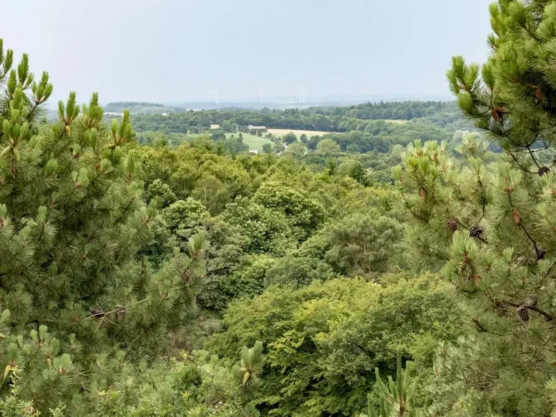
The GR52 is often described as the "wilder sibling" of the GR5. While the latter provides a more direct route to the sea, the GR52 detours into the most rugged, mineral-rich, and historically significant sections of the Mercantour National Park. The trail is defined by its "mineral" character—vast boulder fields, sharp granite ridges, and high-altitude scree slopes that give the landscape an austere, almost lunar quality. This is a landscape shaped by the slow grind of ancient glaciers, leaving behind a series of hanging valleys and over 20 alpine lakes that shimmer in shades of turquoise and deep cobalt. The route is physically demanding, frequently crossing passes (baisses) exceeding 2,400 metres, requiring walkers to be comfortable with steep ascents and technical descents on loose terrain.
One of the primary draws of the GR52 is the Vallée des Merveilles (Valley of Wonders). This high-altitude sanctuary contains over 40,000 Bronze Age rock carvings, etched into the colourful schist and sandstone by prehistoric shepherds. Walking through this section feels like traversing a sacred space, where the weight of human history is palpable against the backdrop of Mount Bégo. As the trail progresses southward, the granite gives way to limestone, and the vegetation undergoes a startling transformation. The dense forests of larch and stone pine are replaced by holm oaks, olive trees, and fragrant lavender. The final day of the trek is legendary: a long, knee-testing descent from the final ridges of the Alps directly into the coastal town of Menton. Standing at the trailhead in the morning at 1,000 metres and swimming in the Mediterranean by the afternoon is a sensory experience unique to this corner of Europe.
The GR52 is a trail of contrasts. It offers the solitude of high-alpine wilderness where chamois and ibex outnumber humans, yet it concludes in the sophisticated glamour of the Côte d'Azur. It requires the grit of a mountaineer but rewards the walker with the hospitality of French mountain refuges, where communal meals of daube provençale and local cheeses provide the necessary fuel for the days ahead. For those seeking a trek that combines technical challenge, archaeological wonder, and a spectacular finish, the GR52 stands as a premier European destination.
History and Cultural Context
The history of the GR52 is inextricably linked to the unique geography of the Mercantour, a region that has served as a crossroads for cultures, armies, and shepherds for millennia. Long before it was a recreational trail, these paths were part of the "Salt Routes" (Routes du Sel), used to transport precious salt from the Mediterranean coast to the inland valleys of Piedmont and Savoy. The rugged terrain meant that these journeys were perilous, requiring intimate knowledge of the mountain passes and weather patterns.
The most significant historical feature of the trail is the Vallée des Merveilles. Discovered by modern archaeology in the late 19th century, the rock carvings date back to the early Bronze Age (approximately 3,000–1,500 BC). These petroglyphs, depicting bulls, weapons, and mysterious geometric figures, are believed to have been created by pastoralists who worshipped the mountain as a source of life-giving water and a site of powerful storms. The area around Mount Bégo was likely a site of pilgrimage, a high-altitude cathedral where the ancient inhabitants of the Mediterranean basin sought to appease the gods of the sky. Today, the valley is a protected archaeological site of global importance, and the GR52 provides the primary means of access for those wishing to see these carvings in their original context.
In more recent history, the region was a theatre of conflict during World War II. The border between France and Italy was heavily fortified, and walkers will still encounter the ruins of military barracks, bunkers, and mule tracks built by Alpine troops (the Chasseurs Alpins). The Mercantour National Park was officially established in 1979, one of the youngest national parks in France, created to protect the exceptional biodiversity and cultural heritage of the Maritime Alps. The GR52 was developed as a way to showcase the park's most dramatic landscapes while maintaining the integrity of its fragile ecosystems. Walking the trail today is an act of traversing these layers of time—from the prehistoric carvings to the military ruins, all contained within a modern framework of environmental conservation.
Want more background? Read extended notes on history and cultural context → Learn more
Seasonal Highlights and Weather Reality
The window for completing the GR52 is relatively narrow due to its high average elevation. The primary season runs from mid-June to late September. Outside of this window, the high passes (such as the Baisse du Basto and Pas de l'Arpette) are typically choked with snow, requiring crampons, ice axes, and advanced winter mountaineering skills. Even in June, "névés" (permanent snow patches) can linger on north-facing slopes, making certain sections treacherous for those without proper footwear.
July and August are the most popular months, offering the most stable weather and fully operational refuges. During this time, the alpine meadows are in full bloom, with edelweiss, gentians, and martagon lilies adding splashes of colour to the rocky terrain. However, these months also bring the risk of "orages" (afternoon thunderstorms). These storms can develop with terrifying speed in the Maritime Alps, bringing heavy rain, lightning, and sudden drops in temperature. Walkers are advised to start their days early—often by 7:00 AM—to ensure they have crossed the highest passes before the typical mid-afternoon storm window.
September is considered by many to be the "golden window" for the GR52. The crowds of the summer holidays have dissipated, the air is crisp and clear, and the light has a soft, autumnal quality that is perfect for photography. The risk of thunderstorms decreases, though the days become shorter and the nights at high-altitude refuges can be quite cold, often dropping below freezing. By early October, the first significant snowfalls usually arrive, effectively closing the high-altitude sections of the trail for the season. The lower sections near Menton remain walkable year-round, but the full traverse is strictly a summer endeavour.
Recommended Itinerary
6-Day GR52 Itinerary: Saint-Martin-Vésubie to Menton
Day 1: Le Boréon to Refuge de la Madone de Fenestre
- Distance: 12 km
- Elevation gain: 1,100 m
- Time: 5–6 hours
- Start at Le Boréon (accessible from Saint-Martin-Vésubie)
- Ascend through ancient larch forests into the high alpine zone
- Cross the Pas des Ladres (2,448 m) with views of the Cime du Gélas
- Descend to the historic Sanctuary of Madone de Fenestre
- The sanctuary, located at 1,900 m, has been a site of pilgrimage for centuries
- Stay at the Refuge de la Madone de Fenestre (FFCAM)
Day 2: Madone de Fenestre to Refuge de Nice
- Distance: 7 km
- Elevation gain: 750 m
- Time: 4–5 hours
- A shorter but very steep and technical day
- Ascend the Pas du Mont Colomb (2,548 m), a narrow notch in the granite ridge
- The descent from the pass is steep and requires careful footwork on loose scree
- Enter the Gordolasque Valley, known for its dramatic waterfalls and chamois populations
- Arrive at Refuge de Nice (2,232 m), perched above the Lac de la Fous
- This is one of the most "alpine" settings on the entire trek
Day 3: Refuge de Nice to Refuge des Merveilles
- Distance: 10 km
- Elevation gain: 850 m
- Time: 6–7 hours
- The "Queen Stage" of the GR52, crossing the highest point of the trail
- Ascend to the Baisse du Basto (2,693 m) for panoramic views of the Mercantour
- Cross the Baisse de la Valmasque and enter the Vallée des Merveilles
- Pass the Lac Noir and Lac du Mouton
- Observe the first of the prehistoric rock carvings near the trail
- Arrive at Refuge des Merveilles (2,111 m) on the shores of Lac de la Meije
Day 4: Refuge des Merveilles to Camp d'Argent
- Distance: 14 km
- Elevation gain: 600 m
- Time: 5–6 hours
- Ascend the Pas de l'Arpette (2,511 m) for a final look back at the high granite peaks
- The landscape begins to soften as you descend into the forest
- Follow the ridge line of the Pointe des Trois Communes
- Pass through ruins of military fortifications from the 19th and 20th centuries
- Arrive at the small ski station of Camp d'Argent on the Col de Turini
- Accommodation available in local gîtes or small hotels
Day 5: Camp d'Argent to Sospel
- Distance: 18 km
- Elevation loss: 1,400 m
- Time: 6–7 hours
- A long descent through changing ecological zones
- The trail follows the ridge of the Mangiabo, offering views of the sea for the first time
- Pass through chestnut groves and Mediterranean scrubland
- The air becomes noticeably warmer and more aromatic
- Arrive in the medieval town of Sospel, famous for its 11th-century bridge
- Sospel offers full amenities, including supermarkets and numerous gîtes
Day 6: Sospel to Menton
- Distance: 19 km
- Elevation gain: 900 m / Elevation loss: 1,250 m
- Time: 7–8 hours
- The final push to the Mediterranean
- Ascend to the Col du Razet and the Col de Berceau (1,090 m)
- From the Col de Berceau, the view of Menton and the Italian coast is spectacular
- A long, steep descent through limestone cliffs and olive terraces
- The trail ends at the Garavan station or the beach in Menton
- Celebrate with a swim in the sea and a meal in the Old Town
Important Notes:
- Refuges must be booked well in advance, especially in July and August
- The section through the Vallée des Merveilles is strictly regulated; do not leave the path
- Water can be scarce on the final two days; carry at least 3 litres
- The descent into Menton is very hard on the knees; trekking poles are highly recommended
- Check the weather forecast daily for "orages" (thunderstorms)
Planning and Bookings
Book Your Trip
Everything you need to plan your journey
Accommodation
Find places to stay near Nice
Flights
Search flights to Nice
Essential Preparation
The GR52 is a demanding trek that requires a high level of physical fitness and mountain experience. Walkers should be comfortable with daily ascents of 800–1,000 metres and carrying a pack weighing 10–12 kilograms. Training should focus on cardiovascular endurance and leg strength, ideally including several day hikes with significant elevation change in the weeks leading up to the trip.
Logistically, the trek requires careful coordination. The starting point, Le Boréon or Saint-Martin-Vésubie, is accessible from Nice via the "Bus 100% Neige" or regular regional bus lines (Line 90). It is advisable to spend a night in Saint-Martin-Vésubie to acclimatise and check last-minute gear. The finish in Menton is well-connected by train (TER) to Nice, Monaco, and Italy, making the return journey straightforward. Booking refuges is the most critical part of preparation; the FFCAM (French Alpine Club) system is the primary platform for the high-altitude huts.
Trail Accommodation
Accommodation on the GR52 is a mix of high-altitude refuges, village gîtes, and small hotels. The refuges are generally open from mid-June to late September.
Refuge Facilities:
- Dormitory-style sleeping (couchettes) with blankets provided (silk liner required)
- Half-board (demi-pension) including dinner and breakfast is the standard
- Common areas for socialising and drying gear
- Limited solar-powered electricity (charging phones is often difficult or restricted)
- Cold water is standard; hot showers are sometimes available for a small fee (3–5 Euros)
- Packed lunches (pique-nique) can be ordered the night before
What Refuges Don't Provide:
- Towels or toiletries
- Private rooms (most are large dorms)
- WiFi or reliable mobile signal
- Bed linen (you must bring a "sac à viande" or silk sleeping bag liner)
Booking Requirements:
- Bookings should be made 2–4 months in advance for peak summer
- Most refuges can be booked online via the FFCAM website or the Mercantour National Park portal
- Wild camping (bivouac) is permitted in the Mercantour National Park but only between 7:00 PM and 9:00 AM, and at least one hour's walk from the park boundaries or road access. Bivouacking is strictly forbidden in the Vallée des Merveilles.
Required Gear
- Sturdy trekking boots - high-cut with a stiff sole for scree and rocky terrain
- Trekking poles - essential for saving knees on the 5,000 m of descent
- Waterproof jacket - high-quality hardshell (Gore-Tex or similar) for alpine storms
- Insulating layers - fleece or lightweight down jacket (even in summer, it can freeze at night)
- Backpack - 35–50 litres with a proper suspension system and rain cover
- Navigation - IGN Maps (3741OT and 3841OT) and a compass/GPS
- Silk sleeping bag liner - mandatory for hygiene in refuges
- Headlamp - with spare batteries for early starts and refuge use
- Sun protection - high SPF sunscreen, lip balm, and Category 3 or 4 sunglasses
What to Bring
- Water filtration - tablets or a filter (Micropur or Sawyer) for stream water
- Personal first aid kit - including blister plasters (Compeed), antiseptic, and pain relief
- Cash - many refuges do not accept credit cards for small purchases or drinks
- Snacks - high-energy bars, nuts, and dried fruit (limited resupply between villages)
- Toiletries - biodegradable soap, travel towel, and hand sanitiser
- Mobile phone and power bank - for emergency use (signal is intermittent)
- Identification - passport or ID card for refuge check-ins
- Lightweight sandals - for use inside the refuges (boots are not allowed in sleeping areas)
Permits
There is no general "permit" required to walk the GR52 or enter the Mercantour National Park. Access is free for all hikers. However, the trail passes through the highly protected archaeological zone of the Vallée des Merveilles, which is subject to very strict regulations enforced by park rangers.
Vallée des Merveilles Regulations:
- You must stay strictly on the marked GR52 path. Leaving the trail to get a closer look at carvings is strictly prohibited and carries heavy fines.
- Trekking poles must have rubber tips (embouts) to prevent scratching the rocks. If you do not have rubber tips, you must carry your poles in your pack through this section.
- Touching the rock carvings is strictly forbidden; the oils from human skin can damage the ancient etchings.
- Camping and bivouacking are completely prohibited within the central archaeological zone.
- Guided tours are required if you wish to leave the main trail to see the most famous carvings (such as "The Sorcerer" or "The Chief of the Tribe"). These can be booked at the Refuge des Merveilles or in Tende.
Refuge Bookings: While not a "permit," your refuge confirmation serves as your de facto permission to stay overnight in the park. During the high season, rangers may ask where you are staying to ensure the bivouac rules are being respected. If you plan to bivouac, ensure you are familiar with the specific zones where it is allowed (outside the Merveilles and away from the core "Zone Centrale" in some cases).
Other Activities in the Area
The Mercantour and the French Riviera offer a wealth of activities to complement your trek:
- Alpha Wolf Park (Le Boréon): Located at the start of the trail, this park allows you to observe three packs of wolves in a semi-natural environment and learn about their reintroduction to the Alps.
- Guided Petroglyph Tours: Spend an extra day at the Refuge des Merveilles to take a 3-hour guided tour with a certified archaeologist to see the carvings that are hidden from the main trail.
- Canyoning in the Maglia: Near Sospel, the Maglia canyon is one of the most beautiful in Europe, offering turquoise pools, natural slides, and abseils.
- Musée des Merveilles (Tende): If you have time for a detour, this museum provides the definitive scientific and historical context for the rock carvings you saw on the trail.
- Menton Old Town: After finishing, explore the Basilica of Saint-Michel, the Jean Cocteau Museum, and the famous botanical gardens (Jardin Serre de la Madone).
- Via Ferrata: Several spectacular via ferrata routes are located near Saint-Martin-Vésubie and Tende for those seeking more vertical thrills.
Safety and Conditions
Weather Hazards: The primary safety concern on the GR52 is the weather. The Maritime Alps are notorious for sudden, violent thunderstorms (orages). These usually occur in the afternoon. If you see dark, towering cumulus clouds forming, descend from high ridges and passes immediately. Lightning is a genuine threat on the exposed "baisses." Additionally, fog can roll in quickly, reducing visibility to a few metres and making navigation through boulder fields extremely difficult.
Terrain: The GR52 is more technical than the average GR trail. You will encounter long sections of "pierriers" (unstable boulder fields) and steep scree slopes. Ankle injuries are the most common ailment. Ensure your boots have good lateral support and take your time on the descents. In early summer, the "névés" (snow patches) can be hard and icy in the morning; a slip without an ice axe can result in a long, dangerous slide.
Water and Heat: While the first few days have plenty of alpine lakes and streams, the final two days (Sospel to Menton) can be extremely hot and dry. Dehydration and heatstroke are risks as you descend into the Mediterranean climate. Carry more water than you think you need for the final stages—at least 3 litres per person.
Emergency Contacts: The European emergency number is 112. Note that mobile signal is non-existent in many of the deep valleys and high passes. If an accident occurs, you may need to send a member of your party to the nearest refuge or high point to find a signal. Carrying a Personal Locator Beacon (PLB) is recommended for solo hikers.
Fauna: While the ibex and chamois are harmless, the region is home to Patou dogs (large white livestock guardian dogs). If you encounter a flock of sheep, the Patou will likely bark and approach you. Do not run, do not shout, and do not make eye contact. Walk slowly around the flock, giving them a wide berth. The dog is simply doing its job to protect the sheep from wolves.
Side Trips and Points of Interest
Cime du Gélas (3,143 m): The highest peak in the Mercantour. For experienced mountaineers, an ascent of the Gélas from the Refuge de la Madone de Fenestre offers an unparalleled view of the entire Alpine chain and the Mediterranean. It requires a scramble (Grade F/PD) and often involves crossing a glacier/snowfield.
The "Valmasque" Lakes: On Day 3, instead of heading straight to the Merveilles, you can take a slight detour to visit the Lac Vert, Lac Noir, and Lac du Mouton in the Valmasque valley. These lakes are often quieter than the Merveilles and offer stunning reflections of the surrounding peaks.
The Ruins of Authion: Near Camp d'Argent, the Authion massif is a natural fortress. You can explore the ruins of the Fort de la Redoute Pointe, which saw heavy fighting in 1793 and again in 1945. The 360-degree views from the top are some of the best on the trail, stretching from the Ecrins to the Corsican coast on a clear day.
The Village of Piène-Haute: A short detour on the final day leads to this spectacular "perched" village overlooking the Roya Valley. It is a perfect example of the traditional architecture of the Alpes-Maritimes and offers a quiet alternative to the busier coastal paths.
Leave No Trace
The Mercantour National Park is one of the most biodiverse regions in Europe, home to rare species like the Bearded Vulture (Gypaète barbu) and the Alpine Ibex. The GR52 passes through the "Zone Centrale" of the park, where regulations are strictly enforced to preserve this fragile environment. As a walker, you are a guest in a protected sanctuary.
Core Principles for the GR52:
- Respect the Silence: The park is a refuge for wildlife. Avoid loud music or shouting, especially near nesting sites of large raptors.
- No Fires: Wildfires are a massive risk in the Mediterranean climate. Fires are strictly prohibited throughout the park. Use a lightweight camping stove only in designated bivouac areas.
- Manage Your Waste: There are no bins in the mountains. Pack out every piece of litter, including organic waste like orange peels or apple cores, which do not decompose quickly in the high-alpine environment and can be harmful to local fauna.
- Protect the Water: Do not use soap or detergent in the alpine lakes or streams. Even biodegradable soap can disrupt the delicate chemical balance of these high-altitude ecosystems. Wash at least 50 metres away from any water source.
- Stay on the Path: Erosion is a major issue on steep alpine slopes. Cutting switchbacks destroys vegetation and leads to trail degradation.
- No Dogs: To protect wildlife and prevent conflict with livestock guardian dogs, pets are strictly prohibited in the central zone of the Mercantour National Park, even on a leash.