GR50: Tour du Haut-Dauphiné – The Grand Alpine Loop
The GR50, also known as the Tour du Haut-Dauphiné, is one of France's most ambitious and rewarding long-distance trekking circuits. Spanning approximately 190 kilometres through the heart of the Southern French Alps, this challenging route offers a profound immersion into the rugged beauty of the Queyras Regional Natural Park and the surrounding massifs of the Hautes-Alpes. Starting and ending in the historic fortified city of Briançon—the highest city in the European Union—the trail weaves through a landscape of dramatic contrasts: from sun-drenched larch forests and traditional stone-and-wood villages to high-altitude mountain passes exceeding 2,800 metres. With a staggering total elevation gain of 12,000 metres, the GR50 is not merely a walk; it is a high-altitude odyssey that demands physical resilience, careful navigation, and a deep appreciation for the solitude of the high mountains.
- Distance: 190.0 km loop
- Duration: 10–14 days
- Season: June to September (summer months)
- Accommodation: Gîtes d'étape, mountain refuges, and local hotels
- Highest point: Col de Chamoussière (2,884 m)
- Difficulty: Challenging (significant elevation gain and sustained high-altitude sections)
- Direction: Typically walked clockwise or anti-clockwise from Briançon
Overview
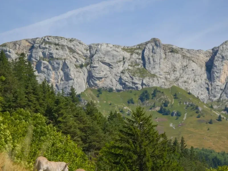
The GR50 is a masterclass in alpine diversity, circumnavigating the high peaks of the Queyras and the eastern fringes of the Écrins National Park. Unlike the more famous Tour du Mont Blanc, which can often feel crowded, the GR50 offers a more authentic and tranquil experience of the French Alps. The route is defined by its "balcony" sections—long stretches of trail that contour along mountain slopes, providing uninterrupted panoramas of the surrounding summits, including the iconic pyramid of Monte Viso (3,841 m) just across the Italian border.
The journey is characterised by its rhythmic progression through distinct ecological zones. You will begin in the dry, Mediterranean-influenced valleys near Briançon, where the air is scented with lavender and wild thyme. As you ascend, you enter the realm of the larch (mélèze), the signature tree of the Southern Alps, which turns a brilliant emerald in summer and a fiery gold in autumn. Above the tree line, the landscape transforms into a stark, mineral world of scree slopes, alpine meadows (alpages) dotted with marmots, and turquoise glacial lakes that reflect the jagged limestone and crystalline peaks.
Physically, the GR50 is a formidable undertaking. The 12,000 metres of ascent are distributed across numerous high passes (cols), often requiring 800 to 1,200 metres of climbing in a single day. The terrain varies from well-maintained forest tracks to narrow, rocky paths that require a steady foot. However, the reward for this exertion is unparalleled: the opportunity to stay in some of France's highest and most traditional villages, such as Saint-Véran, and to experience the unique culture of the Queyras—a region that remained isolated for centuries, developing its own distinct architectural style and communal traditions.
This is a landscape shaped by the elements. The Southern Alps are famous for their exceptional sunshine—averaging 300 days a year—which creates a luminous quality to the light that has long attracted artists and photographers. Yet, the mountains remain unpredictable; sudden afternoon thunderstorms can transform the sun-baked slopes into a theatre of lightning and torrential rain within minutes. For the prepared trekker, the GR50 is a journey of discovery, testing the limits of endurance while offering a front-row seat to the raw majesty of the Haut-Dauphiné.
History and Cultural Context
The history of the GR50 is inextricably linked to the unique political and social history of the Queyras and the Briançonnais. For centuries, these high valleys were part of the "Republic of the Escartons," a unique federation of mountain communities that enjoyed a high degree of autonomy from the 14th to the 18th century. This "republic" allowed the local population to manage their own affairs, leading to a remarkably high literacy rate and a sophisticated system of communal resource management. Walking the GR50, you will see the remnants of this history in the architecture of the villages, where large communal bread ovens and intricate sundials (cadrans solaires) are common sights.
The trail also passes through Briançon, a city whose fortifications are a UNESCO World Heritage site. Designed by the famous military engineer Vauban in the 17th century to protect the border with the Duchy of Savoy, these massive stone walls and forts are a testament to the strategic importance of this mountain crossroads. The GR50 utilizes many ancient paths that were once the only lifelines for these remote communities—routes used by shepherds moving their flocks (transhumance), salt merchants, and pilgrims.
In the higher reaches of the trail, particularly near the Italian border, the history is one of migration and conflict. During the Second World War, these passes were the site of intense resistance activity and skirmishes. Today, the border is invisible, but the cultural exchange remains; many of the mountain refuges serve food that reflects both French and Italian influences, and the local dialects often share common roots. The Queyras itself was only truly opened to the outside world with the construction of the road through the Combe du Queyras in the early 20th century, preserving a sense of "the world apart" that trekkers still feel today.
Want more background? Read extended notes on history and cultural context → Learn more
Seasonal Highlights and Weather Reality
The window for completing the full GR50 is relatively narrow, dictated by the presence of snow on the high passes. While the lower valleys near Briançon may be accessible from May, the higher cols (such as the Col de Chamoussière or Col Vieux) often remain snow-covered until late June or even early July.
June: This is the month of the "alpine spring." The meadows are a riot of colour with gentians, anemones, and lilies. However, trekkers must be prepared for significant snow patches on north-facing slopes, which may require an ice axe or at least trekking poles and good boots. Many refuges only open in mid-June.
July and August: These are the peak months for trekking. The weather is generally stable and warm, with long daylight hours. This is the best time for high-altitude sections, as the snow has mostly melted. However, this is also the season of the "orages" (afternoon thunderstorms). It is essential to start early and aim to be over the highest passes by midday to avoid being caught in exposed areas during a storm.
September: Many experienced trekkers consider this the finest month for the GR50. The crowds of August have dissipated, the air is crisp and clear, and the risk of thunderstorms decreases. In late September, the larch trees begin their spectacular transformation to gold. However, the days are shorter, and temperatures at night can drop below freezing at higher elevations. Some refuges begin to close in mid-to-late September, so careful planning is required.
Winter (October to May): The GR50 is not a hiking trail in winter. It becomes the domain of ski tourers and snowshoers. The high passes are prone to avalanches, and the trail markings are buried under metres of snow. Attempting the route during this time requires advanced mountaineering skills and winter survival equipment.
Recommended Itinerary
10-Day GR50 Circuit Itinerary
Day 1: Briançon to Villard-Saint-Pancrace
- Distance: 12 km
- Elevation gain: 450 m
- Time: 4 hours
- Start in the Cité Vauban (Old Town) of Briançon
- Descend through the historic gates and cross the Durance River
- Follow the balcony trail overlooking the Briançon valley
- Pass through small hamlets with traditional stone houses
- Arrive in Villard-Saint-Pancrace, a quiet village known for its wood-carving heritage
- A gentle introduction to the trail, allowing time to explore Briançon's fortifications
Day 2: Villard-Saint-Pancrace to Arvieux
- Distance: 18 km
- Elevation gain: 1,100 m
- Time: 6–7 hours
- A significant climb towards the Col des Ayes (2,477 m)
- Enter the Queyras Regional Natural Park
- Spectacular views of the Pic de Rochebrune
- Descent through larch forests into the Arvieux valley
- Pass through the hamlet of Brunissard
- Arrive in Arvieux, famous for its traditional "fuste" architecture (log cabins)
Day 3: Arvieux to Ceillac
- Distance: 16 km
- Elevation gain: 950 m
- Time: 6 hours
- Climb to the Col de Bramousse (2,251 m)
- Traverse high alpine pastures where sheep graze in summer
- Steep descent into the Cristillan valley
- Arrive in Ceillac, a beautifully preserved village at 1,640 m
- Ceillac is a hub for outdoor activities and offers excellent gîtes
Day 4: Ceillac to Saint-Véran
- Distance: 15 km
- Elevation gain: 1,150 m
- Time: 6–7 hours
- Climb to the Col des Estronques (2,651 m)
- One of the most scenic passes on the route, with views of the Font Sancte
- Long descent towards the Aigue Blanche valley
- Arrive in Saint-Véran, officially one of the "Most Beautiful Villages in France"
- At 2,042 m, it is often cited as the highest inhabited village in Europe
Day 5: Saint-Véran to Refuge Agnel
- Distance: 14 km
- Elevation gain: 900 m
- Time: 5–6 hours
- Follow the valley floor before climbing towards the Col de Chamoussière (2,884 m)
- The highest point of the GR50
- Breathtaking views of Monte Viso (3,841 m) across the border
- Descent to the Refuge Agnel, located near the Italian border
- High-altitude environment with potential for snow patches even in summer
Day 6: Refuge Agnel to L'Échalp
- Distance: 16 km
- Elevation gain: 400 m gain, 1,100 m descent
- Time: 5–6 hours
- Climb to the Col Vieux (2,806 m)
- Pass the stunning Lac Foréant and Lac Egorgéou
- Follow the Guil River as it descends into the high valley
- Arrive in the remote hamlet of L'Échalp
- This section is famous for its marmot colonies and dramatic rock formations
Day 7: L'Échalp to Abriès
- Distance: 14 km
- Elevation gain: 800 m
- Time: 5 hours
- Climb to the Crête de Gilly for panoramic views of the upper Queyras
- Descend through meadows and forests
- Arrive in Abriès, a vibrant village and historic market centre
- Opportunity to restock supplies and enjoy local Queyras cheese
Day 8: Abriès to Fonts de Cervières
- Distance: 19 km
- Elevation gain: 1,200 m
- Time: 7–8 hours
- A long and demanding day crossing the Col de Thures (2,593 m)
- Pass the "Demoiselles Coiffées" (earth pyramids) near the trail
- Enter the remote and wild Cervières valley
- Arrive at the Refuge des Fonts de Cervières, a cluster of traditional alpine huts
- No mobile signal here—true mountain isolation
Day 9: Fonts de Cervières to Montgenèvre
- Distance: 17 km
- Elevation gain: 850 m
- Time: 6 hours
- Climb to the Col de Bousson (2,154 m) on the Italian border
- Follow the ridge line with views of the Cottian Alps
- Descend towards the ski resort of Montgenèvre
- Pass through fortifications dating from the 19th and 20th centuries
- Montgenèvre offers a transition back to more modern amenities
Day 10: Montgenèvre to Briançon
- Distance: 15 km
- Elevation gain: 400 m gain, 1,200 m descent
- Time: 5–6 hours
- Climb towards the Fort de la Croix de Bretagne for a final view of the massif
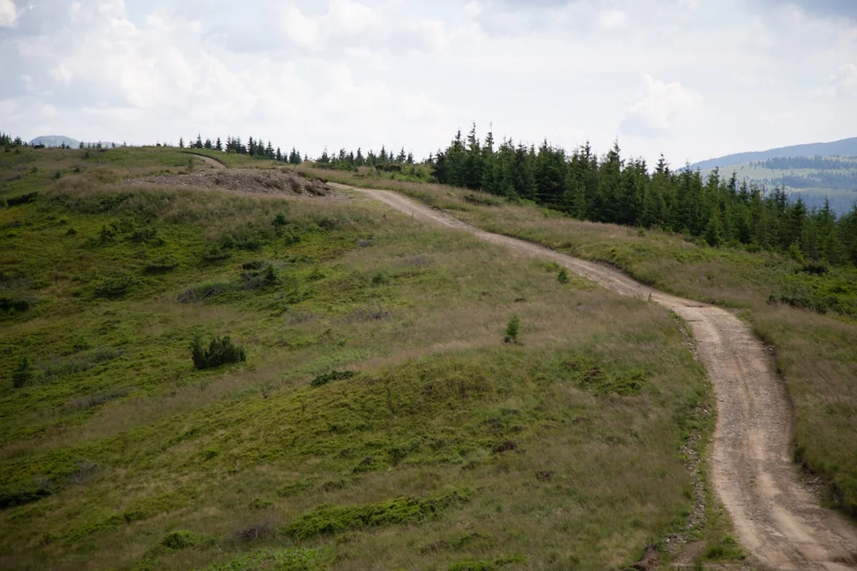
- Long, winding descent through pine forests back towards Briançon
- Enter the city via the upper fortifications
- Finish the loop in the heart of the Cité Vauban
- Celebrate the completion of the 190 km journey in one of the local bistros
Important Notes:
- The itinerary can be extended to 14 days by taking shorter stages or adding rest days in villages like Ceillac or Saint-Véran.
- Water is generally available in villages, but high-altitude sections require carrying at least 2 litres.
- Refuges and gîtes must be booked in advance, especially in July and August.
- The trail is marked with the standard red and white stripes of a Grande Randonnée (GR).
Planning and Bookings
Book Your Trip
Everything you need to plan your journey
Accommodation
Find places to stay near Briançon
Flights
Search flights to Briançon
Essential Preparation
The GR50 is a serious mountain undertaking that requires a high level of physical fitness. Trekkers should be comfortable walking 6–8 hours a day with a loaded pack, often involving over 1,000 metres of ascent. Training on hilly terrain prior to the trip is highly recommended. Briançon is the primary logistical hub; it is well-connected by train (including a night train from Paris) and bus from Marseille or Turin. It is advisable to spend at least one night in Briançon before starting to acclimatise and finalise gear. The local "Maison du Tourisme" and the "Maison du Parc du Queyras" provide excellent maps and up-to-date information on trail conditions.
Trail Accommodation
The GR50 is well-served by a network of accommodation options, ranging from rustic mountain refuges to comfortable village gîtes d'étape.
Types of Accommodation:
- Refuges: High-altitude huts (e.g., Refuge Agnel) offering dormitory sleeping and communal meals. Facilities are basic: shared bathrooms, often limited hot water, and no WiFi.
- Gîtes d'étape: Located in villages (e.g., Ceillac, Saint-Véran), these are specifically designed for hikers. They offer dorms or small private rooms and usually provide "demi-pension" (dinner, bed, and breakfast).
- Hotels: Available in larger villages like Abriès and Montgenèvre for those seeking more comfort.
- Bivouacking: Allowed in the Queyras Regional Natural Park under strict conditions: tents must be small, pitched only between 7:00 PM and 9:00 AM, and located more than an hour's walk from the nearest road or park entrance.
Booking Requirements:
- Advance booking is essential for July and August. Many gîtes can be booked online via the "Queyras Immobilier" or "Refuges de Montagne" websites.
- Costs: Expect to pay €50–€65 per person for demi-pension in a gîte or refuge.
- Most accommodations provide blankets or duvets, but a lightweight sleeping bag liner (silk or cotton) is mandatory for hygiene.
Required Gear
- Footwear: High-quality trekking boots with good ankle support and a Vibram-style sole. Ensure they are well broken-in.
- Clothing: A layering system is vital. Include moisture-wicking base layers, a fleece or down mid-layer, and a high-quality waterproof/breathable jacket (Gore-Tex or similar).
- Pack: A 40–50 litre backpack with a proper suspension system and rain cover.
- Navigation: IGN maps (1:25,000 scale) for the Queyras and Briançonnais (3536OT, 3537ET, 3637OT). A compass and a GPS or smartphone with offline maps (e.g., IGN Rando or Gaia GPS) are essential.
- Safety: A basic first aid kit, emergency whistle, and a space blanket.
- Trekking Poles: Highly recommended to save your knees during the long descents.
What to Bring
- Water: A 2-litre capacity (bladder or bottles). A portable water filter (e.g., Sawyer Squeeze) or purification tablets are useful for high-altitude streams.
- Food: While dinner and breakfast are provided at gîtes, you need to carry lunch and snacks. Most gîtes offer "panier repas" (packed lunches) for €10–€12 if ordered the night before.
- Sun Protection: High-factor sunscreen, lip balm with SPF, sunglasses (Category 3 or 4), and a wide-brimmed hat. The alpine sun is exceptionally strong.
- Toiletries: Biodegradable soap/shampoo, a quick-dry travel towel, and personal medications.
- Power: A power bank for charging phones/GPS, as plug sockets in refuges are often limited and in high demand.
- Cash: Many remote refuges do not accept credit cards. Carry enough Euros to cover several days of expenses.
Permits
One of the great advantages of the GR50 is that no formal permits are required to hike the trail. Access to the Queyras Regional Natural Park and the surrounding public lands is free for all. However, this freedom comes with the responsibility to follow local regulations designed to protect the environment and the local economy.
Key Considerations:
- Refuge Bookings: While not a "permit," your booking confirmation is your ticket to a bed. In peak season, showing up without a reservation is highly discouraged and may result in being turned away if the refuge is at capacity.
- Group Size: Large organised groups (usually more than 10–12 people) may need to notify the Park authorities in advance, especially if planning to bivouac.
- Bivouac Regulations: As mentioned, bivouacking is regulated. It is not "wild camping" in the sense of staying in one place for multiple days. You must move your tent every morning.
- Protected Areas: Some specific zones within the park are "Réserves Naturelles" where even stricter rules apply (e.g., no dogs, even on a lead). Always check the local signage.
Logistics and Transport:
- Train: The "Train des Neiges" or the regular TER service to Briançon is the most sustainable way to arrive.
- Shuttles: During the summer (July/August), the "Navettes du Queyras" provide bus links between the main villages, which can be useful if you need to skip a stage or return to Briançon early.
- Parking: If arriving by car, long-term parking is available in Briançon (e.g., near the train station or the Champ de Mars), but it may be paid. Some gîtes may allow you to leave a car for a small fee.
Other Activities in the Area
The Hautes-Alpes is a playground for outdoor enthusiasts. Consider adding a few days to your trip to experience these activities:
- Vauban Fortifications: Spend a full day in Briançon exploring the Cité Vauban, the Fort des Salettes, and the Pont d'Asfeld. Guided tours are available and highly recommended for history buffs.
- Via Ferrata: The region is famous for its via ferrata routes. The "Croix de Toulouse" above Briançon or the routes in the Combe du Queyras offer thrilling vertical experiences for those with a head for heights.
- Cycling: The Col d'Izoard (2,360 m) is one of the most legendary climbs in the Tour de France. You can rent road bikes or e-bikes in Briançon or Arvieux to tackle this iconic pass.
- Rafting and Kayaking: The Durance and Guil rivers offer world-class white water. Several outfitters in Briançon and Guillestre provide guided rafting trips.
- Saint-Véran Observatory: Visit the high-altitude observatory near Saint-Véran for an evening of stargazing in some of the clearest skies in Europe.
- Local Markets: Don't miss the weekly markets in Briançon (Wednesday and Sunday) or Abriès to sample local honey, "Tourtons" (fried pastries), and Queyras cheeses like Bleu du Queyras.
Safety and Conditions
Pre-Departure Checks:
- Check the Météo France mountain forecast specifically for the "Massif du Queyras" and "Massif du Briançonnais."
- Consult the FFRandonnée or local Park office for any "alertes sentiers" (trail closures or diversions due to landslides or maintenance).
- Ensure your insurance covers mountain rescue, including helicopter evacuation (often a separate clause in standard travel insurance).
Mountain Hazards: The GR50 is a high-altitude trail, and the primary risks are weather-related. Thunderstorms (orages) are common in July and August. They typically build up in the afternoon. If you see towering cumulus clouds (cumulonimbus) forming, descend from ridges and passes immediately. Hypothermia is a risk even in summer if you get wet and the temperature drops, which it can do rapidly at 2,500 m. Altitude sickness is rare at these elevations but can affect some individuals; stay hydrated and ascend gradually.
Livestock Guardian Dogs (Patous): You will encounter large white dogs (Great Pyrenees) guarding sheep flocks. These are not pets; they are working animals trained to protect the flock from wolves. How to behave: When you see a flock, slow down. If a dog approaches barking, stop. Do not shout, do not throw stones, and do not use your trekking poles aggressively. Speak in a calm voice, let the dog sniff you from a distance, and then walk in a wide circle around the flock. Never walk through the middle of the sheep.
Navigation: While the GR50 is generally well-marked, fog or low cloud can make finding the red and white blazes difficult on rocky plateaus. Always carry a map and compass and know how to use them. Do not rely solely on a smartphone, as batteries drain quickly in the cold and signal is non-existent in many valleys.
Emergency Number: Dial 112 for all emergencies in France. Be prepared to give your coordinates (GPS) and describe your location clearly.
Side Trips and Points of Interest
Pain de Sucre (3,208 m): For those with extra energy at Refuge Agnel, the ascent of the Pain de Sucre is a classic. It is a steep but non-technical hike (though it requires a steady foot on scree) that offers one of the best views in the Alps, looking directly down onto the Italian plains and across to the massive south face of Monte Viso. Allow 3–4 hours return from the Col Vieux.
Lac Miroir and Lac Sainte-Anne: Near Ceillac, these two lakes are among the most beautiful in the region. Lac Miroir is famous for its perfect reflections of the surrounding larch trees, while Lac Sainte-Anne, located at the foot of the Fonte Sancte, is a deep turquoise and the site of a traditional pilgrimage chapel. The GR50 passes near them, but a small detour is well worth the effort.
The "Demoiselles Coiffées": Near the trail between Abriès and the Fonts de Cervières, look out for these strange geological formations—tall columns of eroded earth topped with a "cap" of harder rock. They are a striking example of the unique geology of the Southern Alps.
Fort de la Croix de Bretagne: On the final descent to Briançon, this 19th-century fort offers a commanding view of the entire Durance valley. It is a perfect spot to sit and reflect on the vast loop you have just completed, seeing the distant peaks of the Queyras where you walked days before.
Leave No Trace
The Queyras Regional Natural Park is a fragile ecosystem home to rare species like the Alpine Ibex, the Bearded Vulture, and the endemic Queyras Salamander. With increasing numbers of trekkers, the "Leave No Trace" principles are essential to preserving this wilderness.
Your responsibility as a walker:
- Waste: Pack out all rubbish, including biodegradable items like orange peels or banana skins, which decompose very slowly at high altitudes. Carry a small "rubbish bag" in your pack.
- Human Waste: Use the toilets at refuges and gîtes whenever possible. If you must go on the trail, dig a "cat hole" at least 15 cm deep and at least 60 metres from any water source. Pack out your toilet paper in a sealed bag.
- Water Sources: Do not use soap (even biodegradable) directly in lakes or streams. Carry water 20 metres away for washing.
- Flora and Fauna: Do not pick wildflowers—many are protected species. Observe wildlife from a distance; using binoculars is better than trying to get close for a photo.
- Noise: Respect the silence of the mountains. Avoid loud music or shouting, which can disturb both wildlife and other trekkers.
- Fire: Campfires are strictly prohibited throughout the Park due to the high risk of forest fires in this dry climate.
By following these principles, you ensure that the GR50 remains a pristine and wild experience for those who follow in your footsteps. Tread lightly and leave only footprints.