GR5: The Grande Traversée des Alpes - A Journey from Lake Geneva to the Mediterranean
The GR5 (Grande Randonnée 5) is one of Europe's most legendary long-distance trekking routes, a trans-continental odyssey that stretches from the North Sea in the Netherlands to the azure waters of the Mediterranean Sea in France. However, it is the French Alpine section—the "Grande Traversée des Alpes"—that stands as the crown jewel of the trail. Spanning approximately 660 kilometres from Thonon-les-Bains or Saint-Gingolph on the shores of Lake Geneva (Lac Léman) to the Promenade des Anglais in Nice, this route is a masterclass in mountain diversity. It traverses the entire length of the French Alps, crossing high mountain passes, lush alpine meadows, ancient glacial valleys, and rugged limestone massifs. For thru-hikers, the GR5 represents the ultimate European mountain challenge, requiring four to five weeks of sustained effort through some of the most spectacular protected landscapes on the continent, including the Vanoise, Queyras, and Mercantour National Parks.
- Distance: 660.0 km (Alpine section)
- Duration: 4–5 weeks
- Season: July to September (high passes often snow-bound until late June)
- Accommodation: Mountain refuges (refuges), gîtes d'étape, and limited valley hotels
- Highest point: Col de l'Iseran (2,764 m)
- Total Elevation Gain: Approximately 15,000 m
- Difficulty: Challenging (requires high fitness and mountain experience)
- Direction: Traditionally walked North to South (Lake Geneva to Nice)
Overview
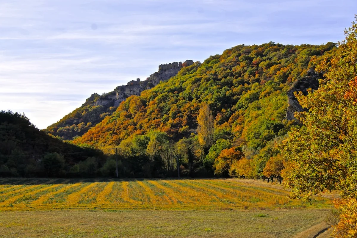
The GR5 is not merely a hike; it is a cultural and geographical immersion into the heart of the European Alps. The trail is designed to showcase the shifting character of the mountains as you move southward. It begins in the lush, humid pre-Alps of the Chablais, where green pastures and dairy farming dominate the landscape. As the hiker progresses, the terrain becomes increasingly dramatic, culminating in the high-altitude granite spires of the Mont Blanc massif and the vast, glaciated plateaus of the Vanoise National Park. Further south, the landscape undergoes a profound transformation. The humid, green valleys of the northern Alps give way to the sun-drenched, arid limestone peaks of the Southern Alps. By the time hikers reach the Mercantour, the air carries the scent of lavender and thyme, and the vegetation shifts to Mediterranean scrub, providing a sensory reward for the thousands of metres of ascent conquered.
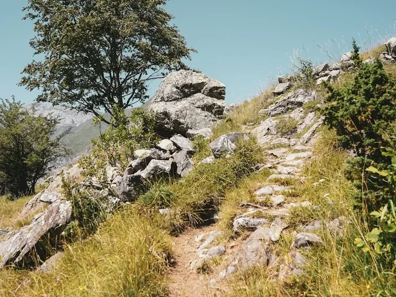
The physical demand of the GR5 is significant. While the trail is generally well-marked with the iconic red-and-white blazes of the Fédération Française de la Randonnée Pédestre (FFRP), the sheer cumulative elevation gain—averaging nearly 1,000 metres of ascent and descent every day—tests the endurance of even the most seasoned trekkers. The route is punctuated by "cols" (mountain passes), many of which exceed 2,500 metres in elevation. These passes serve as the natural rhythm of the trail: a long morning climb followed by a panoramic reward at the summit, and a sustained afternoon descent into a new valley with its own distinct architectural style, dialect, and culinary traditions.
Logistically, the GR5 is supported by an exceptional network of mountain huts (refuges) and village hostels (gîtes d'étape). This allows hikers to complete the journey without carrying heavy camping gear or excessive food supplies, though many choose to "bivouac" (wild camp) where permitted to enhance the wilderness experience. The trail passes through historic mountain towns like Briançon, the highest city in the European Union, and Chamonix, the world capital of mountaineering, offering opportunities to rest and resupply. Whether you are seeking the solitude of the high peaks or the charm of alpine village life, the GR5 delivers a comprehensive mountain experience that is unrivalled in its scope and beauty.
History and Cultural Context
The GR5 is part of the E2 European long-distance path, but its history is deeply rooted in the French tradition of "randonnée" (hiking). The concept of the Grande Randonnée (GR) network was established after World War II by Jean Loiseau, who sought to create a system of marked trails that would allow citizens to rediscover the French countryside on foot. The Alpine section of the GR5 was developed throughout the 1950s and 1960s, linking existing shepherd paths, military roads, and ancient trade routes that had been used for centuries by locals to move livestock and goods between valleys.
Culturally, the trail is a journey through the history of Alpine survival. In the northern sections, you will see the "chalets d'alpage," where Beaufort and Abondance cheeses are still produced using traditional methods. In the Vanoise, the trail passes through lands that were once the hunting grounds of the House of Savoy. The central section around Briançon is dominated by the massive fortifications of Vauban, a 17th-century military engineer whose works are now UNESCO World Heritage sites. These forts were built to guard the high passes against Italian incursions, reminding hikers that these mountains were once a volatile frontier. In the south, the "villages perchés" (perched villages) of the Alpes-Maritimes reflect a history of defensive settlement, with stone houses clinging to ridges to avoid the heat and invaders of the coastal plains.
The trail also honours the natural history of the region. The Vanoise National Park, created in 1963, was the first national park in France, established primarily to protect the Alpine ibex from extinction. Walking the GR5 today, hikers benefit from decades of conservation efforts that have seen the return of the bearded vulture, the chamois, and even the Italian wolf to these mountains. The cultural heritage of the GR5 is thus a blend of human resilience and environmental stewardship.
Want more background? Read extended notes on history and cultural context → Learn more
Seasonal Highlights and Weather Reality
The window for completing the full GR5 is relatively narrow due to the high altitude of the passes. The primary season runs from early July to late September. Outside of this window, snow becomes the defining factor of the trail.
Early Season (June): While the valleys are in full bloom, many of the high passes (above 2,200 metres) remain covered in deep snow. Crossing these without crampons and an ice axe can be dangerous. Many mountain refuges do not open until mid-June or early July, making logistics difficult for those not carrying full camping gear.
High Summer (July and August): This is the peak season. The weather is generally stable, though afternoon thunderstorms (orages) are a frequent and serious hazard. Hikers should aim to cross high passes before 2:00 PM to avoid being caught in lightning. The flora is at its most spectacular in July, with alpine meadows carpeted in gentians, lilies, and rhododendrons. This is also the busiest time, and booking refuges in advance is essential.
Autumn (September): Many experienced hikers consider September the best month for the GR5. The crowds dissipate, the air becomes crisp and clear, and the autumn colours begin to transform the larch forests into gold. However, the days are shorter, and the first dustings of winter snow can arrive on the high peaks. Most refuges close by the third or fourth week of September.
Winter and Spring (October to May): The GR5 becomes a serious mountaineering or ski touring undertaking. The trail is not marked for winter use, and avalanche risk is high throughout the Alpine section. Only those with advanced winter navigation and survival skills should attempt sections of the trail during this period.
Recommended Itinerary
4-5 Week GR5 Alpine Itinerary
Week 1: Lake Geneva to Chamonix (The Chablais and Faucigny)
- Distance: ~110 km
- Key Waypoints: Thonon-les-Bains, Abondance, Saint-Gingolph, Col de Bise, Les Houches
- The journey begins with a steep climb away from the lake into the Chablais mountains.
- Experience the lush green pastures and traditional cheese-making villages.
- Cross the Col d'Anterne for your first dramatic views of the Mont Blanc massif.
- Finish the week descending into the Chamonix Valley, the heart of European alpinism.
Week 2: Chamonix to Landry (Mont Blanc and Beaufortain)
- Distance: ~90 km
- Key Waypoints: Les Contamines-Montjoie, Col du Bonhomme, Plan de la Lai, Landry
- This section overlaps with the famous Tour du Mont Blanc (TMB) for several days.
- Expect rugged terrain and high passes like the Col de la Croix du Bonhomme (2,433 m).
- The Beaufortain region offers stunning views of turquoise reservoirs and jagged peaks.
- A long descent leads to the Tarentaise Valley and the town of Landry.
Week 3: Landry to Modane (Vanoise National Park)
- Distance: ~105 km
- Key Waypoints: Peisey-Nancroix, Col du Palet, Tignes, Entre-Deux-Eaux, Modane
- Enter the Vanoise National Park, a sanctuary for ibex and chamois.
- The trail stays at high altitude, crossing the Col de l'Iseran (2,764 m), the highest point on the route.
- Walk through vast glacial landscapes and stay in remote mountain refuges.
- Descend into the Maurienne Valley to the town of Modane.
Week 4: Modane to Briançon (Cerces and Thabor)
- Distance: ~95 km
- Key Waypoints: Valfréjus, Col de la Vallée Étroite, Névache, Briançon
- The landscape begins to shift toward the drier, sunnier Southern Alps.
- The Cerces massif offers some of the most beautiful limestone scenery on the trail.
- Pass through the Vallée Étroite, a valley with a unique Franco-Italian cultural blend.
- Arrive in Briançon, a UNESCO-listed fortified city, perfect for a rest day.
Week 5: Briançon to Nice (Queyras, Mercantour, and the Mediterranean)
- Distance: ~260 km (often broken into two smaller weeks)
- Key Waypoints: Ceillac, Saint-Véran, Larche, Bousiéyas, Saint-Dalmas, Nice
- Traverse the Queyras Regional Park, known for its high-altitude villages like Saint-Véran.
- Enter the Mercantour National Park, the final wild frontier before the coast.
- The descent toward the Mediterranean is long and hot, passing through olive groves.
- The trail ends spectacularly on the Promenade des Anglais in Nice.
Important Notes:
- The itinerary can be customised based on fitness; many hikers take 35–40 days to allow for rest.
- Refuges should be booked at least 24–48 hours in advance during peak season.
- Water is generally available in villages and at refuges, but high-altitude sections can be dry.
- The trail is marked with red and white stripes; always follow the official FFRP signage.
Planning and Bookings
Book Your Trip
Everything you need to plan your journey
Accommodation
Find places to stay near Briançon
Flights
Search flights to Briançon
Essential Preparation
Preparation for the GR5 must begin months in advance. Physical fitness is the most critical factor; you will be carrying a pack weighing 10–15 kilograms over multiple passes daily. Training should include weighted hill walks and cardiovascular conditioning. Logistically, you must decide whether to walk the entire route in one go or break it into sections. Most hikers start at Lake Geneva and head south to keep the sun at their backs and finish with the Mediterranean reward.
Language is another consideration. While many refuge wardens speak basic English, knowing fundamental French phrases for booking beds and ordering food is highly beneficial and respected. Ensure you have a reliable method for checking weather forecasts (Météo-France is the gold standard) and have downloaded offline maps, as mobile signal is intermittent in the high valleys.
Trail Accommodation
The GR5 is famous for its "refuges" and "gîtes d'étape." These provide a unique social experience and allow for a lighter pack. Refuges are high-altitude huts, often managed by the Club Alpin Français (CAF) or private owners. They offer dormitory-style sleeping and "demi-pension" (half-board), which includes dinner and breakfast. Gîtes d'étape are found in villages and offer similar services but often with more facilities like hot showers and small shops.
Facilities Provided:
- Dormitory beds with blankets or duvets (a silk liner is mandatory for hygiene)
- Communal evening meals (usually three courses) and simple breakfasts
- Basic washing facilities (hot showers often cost extra, around €2–€5)
- Charging stations for electronics (though these can be crowded)
- Boot rooms for storing hiking footwear
What is NOT Provided:
- Towels and toiletries
- Personal sleeping bags (unless winter-room use)
- Private rooms (rare in high refuges, more common in gîtes)
- WiFi (rarely available in high-altitude huts)
Costs and Booking: Expect to pay €50–€70 per night for half-board. Bookings can be made via the FFCAM website for club huts or directly via phone/email for private ones. During July and August, booking weeks in advance is recommended for popular sections like the Vanoise or Mont Blanc.
Required Gear
- Footwear: High-quality trekking boots with excellent ankle support and Vibram soles. Ensure they are thoroughly broken in.
- Clothing: A layering system is essential. Include moisture-wicking base layers, a fleece or down mid-layer, and a high-quality waterproof shell (Gore-Tex).
- Backpack: A 40–55 litre pack with a supportive harness and rain cover.
- Navigation: Topographic maps (IGN 1:25,000 scale) or a dedicated GPS device with spare batteries. A compass is essential for fog.
- Safety Gear: A basic first aid kit, an emergency whistle, and a space blanket.
- Trekking Poles: Highly recommended to save your knees during the 15,000 metres of descent.
What to Bring
- Water Treatment: A lightweight filter or purification tablets. While tap water in villages is safe, stream water should be treated due to livestock.
- Sun Protection: High-factor sunscreen, lip balm with SPF, and high-quality sunglasses (Category 3 or 4 for snow/glaciers).
- Cash: Many refuges do not accept credit cards. Carry enough Euros to cover several days of accommodation and snacks.
- Snacks: High-energy foods like nuts, dried fruit, and chocolate. You can resupply in valley towns every 3–4 days.
- Liner: A silk or cotton sleeping bag liner (sac à viande) is mandatory in all French refuges.
- Headlamp: Essential for navigating dormitories at night and for early morning starts.
Permits
The GR5 does not require a single overarching permit for the entire route. However, because the trail passes through several National and Regional Parks, specific regulations apply, particularly regarding "bivouacking" (temporary wild camping).
National Park Regulations (Vanoise and Mercantour):
- Wild camping is strictly prohibited in the core zones of the National Parks.
- Bivouacking (setting up a small tent at sunset and taking it down at sunrise) is permitted only in designated areas near certain refuges during the summer season. A small fee is sometimes charged for the use of refuge facilities.
- Fires are strictly forbidden in all protected areas.
- Dogs are generally not allowed in the core zones of National Parks, even on a leash, to protect wildlife.
Regional Parks (Queyras and Chablais):
- Regulations are slightly more relaxed, but bivouacking is still restricted to sunset-to-sunrise hours and must be at least one hour's walk from the nearest road or park boundary.
- Always check local signage, as rules can change based on fire risk or conservation needs.
Fishing and Hunting: If you plan to fish in alpine lakes, you must purchase a local or departmental fishing permit (carte de pêche), available at many village tobacco shops (tabacs) or online.
Other Activities in the Area
The French Alps offer a wealth of experiences beyond the trail. If you have extra time, consider these activities:
- Aiguille du Midi (Chamonix): Take the cable car to 3,842 metres for an unparalleled view of Mont Blanc and the surrounding glaciers. It is a breathtaking experience even for those who have just walked past the mountain.
- Via Ferrata: The Alps are the birthplace of via ferrata (iron paths). Many towns along the GR5, such as Briançon and Modane, have spectacular routes ranging from beginner to expert.
- Canyoning and Rafting: The rivers of the Southern Alps, particularly the Ubaye and the Verdon, offer world-class white-water adventures.
- Paragliding: Experience the mountains from the air. Tandem flights are available in Chamonix, Saint-Gervais, and many other alpine resorts.
- Thermal Spas: Reward your tired muscles at the thermal baths in Saint-Gervais-les-Bains or Monetier-les-Bains near Briançon.
- Fortress Tours: Explore the Vauban fortifications in Briançon, a masterpiece of 17th-century military architecture.
Safety and Conditions
Mountain Weather: The greatest objective hazard on the GR5 is the weather. Conditions can change from blistering heat to freezing rain or snow within an hour. Afternoon thunderstorms are common in July and August; they bring intense rain, hail, and dangerous lightning. Always check the "Météo Montagne" forecast before leaving your accommodation and aim to be off high ridges by early afternoon.
Terrain and Navigation: While the GR5 is well-marked, fog can quickly obscure the red-and-white blazes. You must be proficient with a map and compass or a GPS. Some sections involve steep scree slopes or narrow ridges that require a steady head for heights. In early summer, steep snow patches (névés) can be treacherous; if you cannot kick steps into the snow, do not attempt to cross it without proper equipment.
Livestock and Guard Dogs: You will frequently pass through grazing lands. Be aware of "Patous"—large white Great Pyrenees dogs used to protect sheep from wolves. If you encounter a Patou, do not run, do not shout, and do not try to pet it. Stop, keep your poles down, and speak calmly until the dog realises you are not a threat, then walk in a wide circle around the flock.
Health and Hydration: The combination of high altitude and physical exertion increases the risk of dehydration and heatstroke. Drink at least 3 litres of water a day. Be aware of the symptoms of Altitude Sickness (headache, nausea, dizziness) if you are not acclimatised, although the GR5 rarely stays above 3,000 metres for long.
Emergency Services: The European emergency number is 112. Be prepared to give your coordinates and a description of your location. Note that helicopter rescues in France are generally free for genuine mountain accidents, but travel insurance is still essential for medical costs and repatriation.
Side Trips and Points of Interest
Mont Thabor (3,178 m): A popular detour from the GR5 near Valfréjus. This peak offers one of the best 360-degree panoramas in the Alps, stretching from the Ecrins to Mont Blanc. The ascent is non-technical but strenuous.
Lac de l'Anterne: Located in the Sixt-Passy Nature Reserve, this stunning alpine lake reflects the limestone cliffs of the Rochers des Fiz. It is a perfect spot for a long lunch break or a bivouac (where permitted).
Saint-Véran: Often cited as the highest inhabited village in Europe (2,042 m), this village in the Queyras is a living museum of traditional wooden architecture and sundials. The GR5 passes directly through its historic streets.
Vallée des Merveilles: In the Mercantour National Park, a side trip to this "Valley of Wonders" reveals over 40,000 prehistoric rock engravings dating back to the Bronze Age. Access to the engravings is strictly regulated and often requires a guided tour to protect the site.
The Briançon Forts: Take a half-day to hike up to the Fort du Randouillet or Fort des Salettes for a bird's-eye view of the city and the surrounding mountain passes.
Leave No Trace
The GR5 traverses some of the most fragile ecosystems in Europe. With thousands of hikers passing through each year, the cumulative impact can be devastating if Leave No Trace principles are not strictly followed. You are a guest in these mountains; act with the respect that this ancient landscape deserves.
Core Principles for the GR5:
- Plan Ahead and Prepare: Know the regulations for each National Park you enter. Lack of planning often leads to illegal camping or fire-making.
- Travel and Camp on Durable Surfaces: Stay on the marked GR5 path. Taking shortcuts on switchbacks causes severe erosion and destroys alpine flora.
- Dispose of Waste Properly: Pack out everything. This includes fruit peels, nut shells, and cigarette butts. For human waste, use the facilities at refuges. If caught between huts, dig a "cathole" at least 20 cm deep and 60 metres from water sources. Pack out all toilet paper.
- Leave What You Find: Do not pick wildflowers or remove rocks. In the Vallée des Merveilles, touching the rock engravings is strictly prohibited.
- Minimise Campfire Impacts: Fires are illegal in most areas of the GR5. Use a lightweight stove for cooking.
- Respect Wildlife: Observe marmots, chamois, and ibex from a distance. Never feed them, as it disrupts their natural foraging behaviour and health.
- Be Considerate of Others: Keep noise levels low, especially in refuges. Yield to uphill hikers on narrow trails.