GR40 - Tour du Volcan du Velay
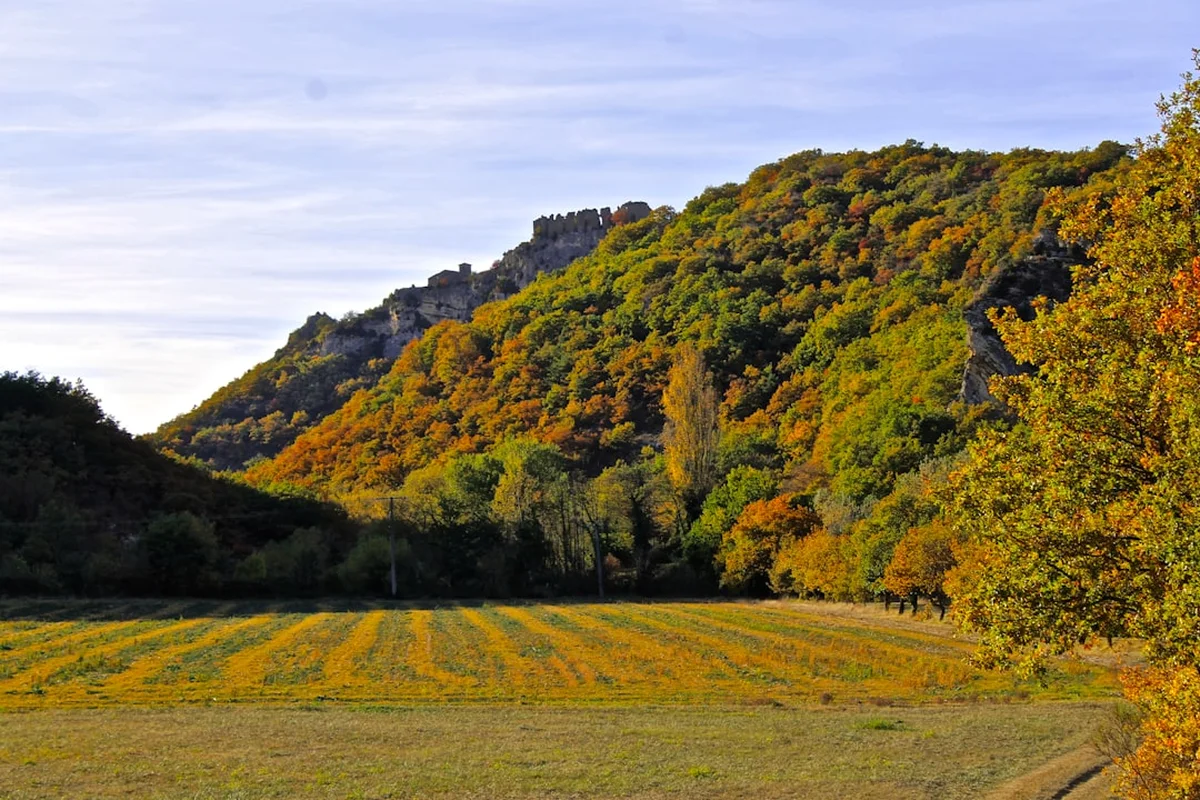
The GR40, known as the Tour du Volcan du Velay, is one of France's most geologically significant and visually arresting long-distance footpaths. Spanning approximately 190 kilometres through the heart of the Haute-Loire department in the Auvergne-Rhône-Alpes region, this circular route offers a profound journey through a landscape sculpted by ancient volcanic activity. Unlike the more jagged peaks of the Alps or Pyrenees, the Velay region is characterised by "sucs"—distinctive dome-shaped volcanic hills—and vast basaltic plateaus carved by the nascent Loire and Allier rivers. Starting and ending near the historic town of La Mure, the trail provides a challenging yet deeply rewarding exploration of rural France, where medieval stone villages cling to hillsides and the silence of the high plateaus is broken only by the sound of cowbells and the wind through the Scots pines.
- Distance: 190.0 km loop
- Duration: 9–12 days
- Total Elevation Gain: 9,500 m
- Difficulty: Challenging (due to cumulative elevation and rugged terrain)
- Best Time: June to September (summer months for stable weather and open facilities)
- Closest City: Grenoble (access via La Mure)
- Highest Point: Near the Massif du Mézenc (approx. 1,500 m on the trail variants)
Overview
The GR40 is a masterclass in geological diversity, taking hikers through a landscape that feels both prehistoric and meticulously preserved. The route circles the Velay basin, a region defined by its volcanic past. Over the course of nearly 200 kilometres, walkers encounter a variety of volcanic formations, from the phonolitic domes (sucs) that dot the horizon like giant molehills to the basaltic "organs" (columnar jointing) exposed in river gorges. The trail is not merely a physical challenge; it is an immersion into the "Midi de l'Auvergne," a land where the harshness of the mountain climate meets the light and warmth of the south.
The journey begins in the southern reaches of the department, near La Mure, and immediately introduces the hiker to the undulating terrain of the Devès plateau. This is the largest basaltic plateau in France, a vast expanse of fertile volcanic soil that supports the famous green lentils of Le Puy. As the trail progresses, it dives into the deep, forested gorges of the Loire, where the river is still a wild, youthful stream, far removed from the wide, castle-lined waterway it becomes in the north. The ascent and descent are constant; with 9,500 metres of total elevation gain, the GR40 demands respect and physical preparation. It is a "mid-mountain" trek, meaning that while the altitudes are not extreme (rarely exceeding 1,500 metres), the cumulative effort of the constant "yo-yo" terrain through valleys and over sucs is significant.
Culturally, the GR40 is a journey through the soul of rural France. Hikers pass through villages built from dark volcanic stone, topped with red-tiled roofs, and encounter a way of life that remains deeply connected to the land. The region is famous for its gastronomy—notably the Lentille Verte du Puy (AOP), the local Fin Gras du Mézenc beef, and artisanal cheeses like the Sarassou. For the independent hiker, the GR40 offers a sense of solitude that is increasingly rare on more famous routes like the GR65 (St James Way), which it occasionally intersects. Here, you are more likely to share the trail with a local farmer or a herd of Salers cattle than a crowd of tourists.
History and Cultural Context
The history of the Velay region is written in its rocks. The volcanic activity that shaped this landscape began roughly 13 million years ago and continued until as recently as 15,000 years ago. The GR40 traverses the three main volcanic massifs of the region: the Devès, the Meygal, and the Mézenc. Each has a distinct character. The Devès is known for its "maars"—crater lakes formed by phreatomagmatic explosions—while the Meygal and Mézenc are famous for their "sucs," which were formed by highly viscous lava that cooled into domes rather than flowing away.
Human history in the Velay is equally layered. The region has been inhabited since the Paleolithic era, but it rose to prominence in the Middle Ages as a major religious centre. Le Puy-en-Velay, which the GR40 skirts and overlooks, became the starting point for the Via Podiensis, one of the main routes of the Camino de Santiago (St James Way). The GR40 often follows ancient pastoral tracks and Roman roads that have been used for millennia by shepherds moving their flocks between the lowlands and the high summer pastures (transhumance). The stone walls (murets) that line many sections of the trail are testament to centuries of patient labour by local farmers clearing the volcanic stones from their fields.
The architecture along the route is a direct reflection of the geology. The "maisons de béate"—small communal houses found in many Velay villages—were once the heart of social and religious life, where a laywoman (the béate) would teach children and lead prayers. These buildings, along with the Romanesque churches and fortified farmhouses, are typically constructed from basalt, breccia, or phonolite, giving the villages a distinctive, somber beauty that harmonises perfectly with the rugged landscape.
Want more background? Read extended notes on history and cultural context → Learn more
Seasonal Highlights and Weather Reality
The GR40 is best experienced during the warmer months, but the high elevation of the Velay plateaus means that weather conditions can be more "mountainous" than the latitude suggests. Even in mid-summer, the plateaus are subject to rapid changes in temperature and sudden, violent thunderstorms.
Spring (May to June): This is a spectacular time for flora. The high pastures are carpeted with wild narcissus, yellow gentians, and mountain pansies. However, May can still see late-season snow on the higher sucs, and the ground can be very boggy after the spring thaw. Many gîtes d'étape begin opening in May, but it is essential to check availability.
Summer (July to August): This is the peak season. The weather is generally stable and warm, with temperatures in the valleys reaching 25–30°C, though the plateaus remain pleasantly cool. This is the best time for the high-altitude sections of the Meygal and Mézenc. The downside is that water sources can dry up, and popular gîtes may be full. Afternoon thunderstorms are a common occurrence and can be intense; hikers should aim to be off high ridges by mid-afternoon.
Autumn (September to October): September is arguably the finest month for the GR40. The air is crisp and clear, providing the best visibility for the distant views of the Alps and the Cantal mountains. The autumn colours in the beech and pine forests are magnificent. By October, the days shorten significantly, and the first frosts appear on the plateaus. Many seasonal accommodations close at the end of September.
Winter (November to April): The GR40 is not recommended for standard hiking during winter. The Velay plateaus are notorious for the "burle"—a freezing north wind that creates massive snowdrifts. The trail becomes an alpine environment requiring snowshoes or cross-country skis, and many sections are impassable. Most accommodation is closed, and navigation becomes extremely difficult in whiteout conditions.
Recommended Itinerary
10-Day GR40 Itinerary
Day 1: La Mure to Vorey-sur-Arzon
- Distance: 18.5 km
- Elevation gain: 450 m
- Time: 5–6 hours
- Key Waypoints: La Mure trailhead, Arzon Valley, Vorey village
- The trail begins with a descent into the lush Arzon Valley, following the river through dense woodland.
- A gentle introduction to the volcanic terrain with views of the first "sucs" in the distance.
- Vorey offers full services including a supermarket and several gîtes.
Day 2: Vorey-sur-Arzon to Saint-Paulien
- Distance: 21 km
- Elevation gain: 650 m
- Time: 6–7 hours
- Key Waypoints: Changeac, Roche-en-Régnier (detour), Saint-Paulien
- A steady climb out of the Loire valley onto the plateau.
- Pass through ancient hamlets built from dark basalt.
- Saint-Paulien is a historic Gallo-Roman town with an impressive Romanesque church.
Day 3: Saint-Paulien to Allègre
- Distance: 17 km
- Elevation gain: 400 m
- Time: 5 hours
- Key Waypoints: Mount Bar, Allègre village
- The highlight is the ascent of Mount Bar, a perfect volcanic cone containing a rare peat bog in its crater.
- Descent into Allègre, famous for the "Gallows of Allègre"—the ruins of a 14th-century castle.
- Excellent views of the Devès plateau to the south.
Day 4: Allègre to Siaugues-Sainte-Marie
- Distance: 22 km
- Elevation gain: 550 m
- Time: 6–7 hours
- Key Waypoints: Varennes-Saint-Honorat, Saint-Bérain, Siaugues
- Crossing the transition zone between the volcanic Velay and the granite Margeride mountains.
- The terrain becomes more rugged with deeper valleys and steeper climbs.
- Siaugues-Sainte-Marie provides essential restocking opportunities.
Day 5: Siaugues-Sainte-Marie to Saint-Jean-Lachalm
- Distance: 24 km
- Elevation gain: 800 m
- Time: 7–8 hours
- Key Waypoints: Allier Gorges, Saint-Privat-d'Allier, Saint-Jean-Lachalm
- A challenging day crossing the deep Allier Gorges.
- The trail intersects with the GR65 (St James Way) at Saint-Privat-d'Allier.
- Significant climb up to the basaltic plateau of Saint-Jean-Lachalm.
Day 6: Saint-Jean-Lachalm to Goudet
- Distance: 19 km
- Elevation gain: 500 m
- Time: 5–6 hours
- Key Waypoints: Lac du Bouchet (detour), Loire Valley, Goudet
- The route passes near the Lac du Bouchet, a stunning circular maar lake.
- A dramatic descent into the young Loire Valley to the village of Goudet, overlooked by the ruins of Beaufort Castle.
- Goudet is one of the most picturesque stops on the trail.
Day 7: Goudet to Le Monastier-sur-Gazeille
- Distance: 16 km
- Elevation gain: 600 m
- Time: 5 hours
- Key Waypoints: Saint-Martin-de-Fugères, Gazeille Valley, Le Monastier
- A climb back onto the plateau with expansive views of the Mézenc massif.
- Le Monastier is famous as the starting point of Robert Louis Stevenson's "Travels with a Donkey."
- Visit the abbey church and the Stevenson museum.
Day 8: Le Monastier-sur-Gazeille to Queyrières
- Distance: 22 km
- Elevation gain: 850 m
- Time: 7 hours
- Key Waypoints: Meygal Massif, Testavoyre (1,436 m), Queyrières
- Entering the heart of the "Sucs" region. The trail climbs into the Meygal forest.
- The ascent of Testavoyre offers 360-degree views of the Auvergne volcanoes.
- Queyrières is built at the foot of a spectacular phonolitic rock plug.
Day 9: Queyrières to Saint-Julien-Chapteuil
- Distance: 15 km
- Elevation gain: 400 m
- Time: 4–5 hours
- Key Waypoints: Suc de Chapteuil, Saint-Julien village
- A shorter day allowing for exploration of the volcanic domes.
- The Suc de Chapteuil features impressive basalt columns and castle ruins.
- Saint-Julien-Chapteuil is a vibrant village with excellent local food shops.
Day 10: Saint-Julien-Chapteuil to La Mure
- Distance: 15 km
- Elevation gain: 350 m
- Time: 4 hours
- Key Waypoints: Sumène Valley, Saint-Pierre-Eynac, La Mure
- The final leg crosses the Sumène Valley and passes the Romanesque church of Saint-Pierre-Eynac.
- A gentle finish through agricultural land and small woodlands back to the starting point.
Important Notes:
- The itinerary can be extended to 12 days for a more relaxed pace.
- Water can be scarce on the basaltic plateaus; carry at least 2 litres.
- The trail is marked with the standard red and white blazes of a GR route.
- Mobile signal is generally good but can be lost in deep gorges.
Planning and Bookings
Book Your Trip
Everything you need to plan your journey
Accommodation
Find places to stay near Grenoble
Flights
Search flights to Grenoble
Essential Preparation
The GR40 requires a moderate to high level of fitness. While the altitudes are not extreme, the cumulative elevation gain of 9,500 metres over 190 kilometres means you will be climbing and descending significantly every day. Training with a weighted pack on undulating terrain is highly recommended. Logistics are relatively straightforward if starting from Grenoble; the bus to La Mure is reliable, but checking the seasonal schedule is vital as services are reduced on weekends and public holidays.
Booking coordination is the most critical part of planning. While the GR40 is less crowded than the St James Way, the number of gîtes d'étape (hikers' hostels) is also more limited. In July and August, it is essential to book your accommodation at least 2–4 weeks in advance. If you are travelling with a dog, verify in advance as many gîtes do not allow pets due to the proximity of livestock.
Trail Accommodation
The GR40 is well-served by a network of "Gîtes d'étape," which are specifically designed for long-distance walkers. These offer dormitory-style sleeping arrangements, communal meals (table d'hôte), and often have facilities for washing clothes.
Accommodation Types:
- Gîtes d'étape: The most common option. Expect to pay €40–€55 for "demi-pension" (dinner, bed, and breakfast). Facilities include hot showers, blankets (bring a silk liner), and shared toilets.
- Chambres d'hôtes: French B&Bs. More expensive (€70–€100) but offer private rooms and higher comfort.
- Campsites: Available in larger villages like Vorey, Saint-Paulien, and Le Monastier. Wild camping (bivouacking) is generally tolerated if you set up at dusk and leave at dawn, but it is strictly forbidden in protected volcanic zones and near Lac du Bouchet.
- Hotels: Limited to larger towns. Useful for a "rest night" in the middle of the trek.
What's NOT Provided: Most gîtes do not provide towels or toiletries. While blankets are provided, a sleeping bag liner (sac à viande) is mandatory for hygiene. Electricity for charging phones is usually available in common areas but may be limited in remote gîtes.
Required Gear
- Footwear: Sturdy trekking boots with good ankle support are essential. The volcanic rock (basalt and phonolite) is very hard and can be sharp; thin-soled trail runners may lead to foot fatigue.
- Rain Gear: A high-quality waterproof jacket (minimum 15,000mm hydrostatic head) and overtrousers. The Velay is prone to sudden, heavy downpours.
- Pack: A 40–50L pack is sufficient for gîte-to-gîte trekking. Ensure it has a waterproof cover.
- Navigation: Topographic maps (IGN 1:25,000) or a reliable GPS app with offline maps (e.g., Iphigénie or OutdoorActive). The GR40 is well-marked, but blazes can be missed in fog or at complex junctions.
- Sun Protection: High-factor sunscreen, sunglasses, and a wide-brimmed hat. The sun on the high plateaus is intense, even when the air feels cool.
What to Bring
- Water Treatment: While tap water in villages is safe, you may need to refill from springs or streams on long sections. A lightweight filter (e.g., Sawyer Squeeze) or purification tablets are recommended.
- Food/Snacks: Carry enough lunch and snacks for each day. While villages have bakeries, they often close for "siesta" (12:30–15:30) and may be closed entirely on Mondays or Sundays.
- First Aid: Blister kits (Compeed), antiseptic wipes, rehydration salts, and any personal medications.
- Cash: Many small gîtes and village shops do not accept credit cards. Carry at least €200–€300 in cash as ATMs are only found in larger towns.
- Power Bank: To ensure your phone/GPS remains charged during long days on the trail.
Permits
One of the great advantages of the GR40 is that no permits or fees are required to walk the trail itself. It is a public right of way. However, there are specific regulations regarding the use of the land that hikers must respect to ensure the trail remains open and accessible.
Key Regulations:
- Wild Camping: Bivouacking (setting up a small tent from 19:00 to 08:00) is generally allowed along the GR40, except in specifically protected areas like the "Réserve Naturelle du Cratère du Mont-Bar" or near the shores of Lac du Bouchet. Always seek permission if camping near a farmhouse.
- Livestock: The trail passes through many active grazing lands. It is mandatory to close all gates behind you. Keep a respectful distance from cattle, especially if they have calves.
- Dogs: While allowed on the trail, dogs must be kept on a lead in areas with livestock and in protected natural zones. Be aware of "Patous" (Great Pyrenees livestock guardian dogs); if you encounter one, stop, stay calm, and let the dog identify you before moving slowly around the herd.
- Fire: Lighting fires is strictly prohibited along the entire route due to the high risk of forest fires in the pine-dominated woodlands.
Group Travel: If you are organising a large group (more than 10 people), it is a courtesy to inform the local Mairies (town halls) of the villages where you plan to stay, as small gîtes may not be able to accommodate sudden large influxes of hikers.
Other Activities in the Area
The Velay region offers a wealth of experiences that complement the GR40. If you have extra days, consider the following:
- Le Puy-en-Velay Exploration: A UNESCO World Heritage site. Visit the Notre-Dame Cathedral, the Cloister, and the startling Saint-Michel d'Aiguilhe chapel perched atop a 82-metre volcanic needle. The nightly "Puy de Lumières" light show in summer is world-class.
- Velay Express: Take a ride on the highest steam railway in France. This historic train runs between Raucoules and Saint-Agrève, offering a nostalgic way to see the plateaus.
- Via Ferrata: For those seeking more adrenaline, there are excellent via ferrata routes in the Gorges de l'Allier and near Le Monastier-sur-Gazeille.
- Lentil Tasting: Visit a local farm to learn about the cultivation of the "Green Diamond of the Velay" (the Puy green lentil) and enjoy a traditional meal of lentils and petit salé (salted pork).
- Fly Fishing: The upper Loire and Allier rivers are legendary among anglers for wild brown trout and grayling.
- Canoeing the Loire: Rent a canoe in Vorey or Goudet for a different perspective on the volcanic gorges from the water.
Safety and Conditions
Weather Awareness: The primary safety concern on the GR40 is the weather. The plateaus are exposed and offer little shelter from lightning. If a storm approaches, descend from ridges and avoid standing near isolated trees or stone walls. Check the "Météo France" mountain forecast for the Haute-Loire daily.
Navigation: While the GR40 is generally well-marked with red and white blazes, some sections on the high plateaus can be confusing in low visibility (fog). Always carry a physical map and compass as a backup to digital devices. Be particularly careful in the Meygal forest, where numerous forestry tracks can intersect the trail.
Water and Hydration: Dehydration is a genuine risk in summer. The volcanic soil is porous, meaning surface water is rare on the plateaus. Never rely on finding water between villages. Fill your bottles at every opportunity in the "fontaines" found in village squares (ensure they are marked "Eau Potable").
Livestock Guardian Dogs (Patous): You will likely encounter Patous. These are not pets; they are working dogs bred to protect sheep from wolves. If a Patou barks and approaches you:
- Stop immediately.
- Do not shout or throw stones.
- Do not look the dog directly in the eyes.
- Talk to it in a calm, low voice.
- Once the dog has sniffed the air and calmed down, walk slowly and widely around the flock.
Emergency Services: The European emergency number is 112. Be prepared to give your coordinates or the name of the nearest "lieu-dit" (hamlet) marked on your map.
Side Trips and Points of Interest
Mount Bar (Allègre): This is a must-visit. It is the only volcano in France of the "Strombolian" type that houses a peat bog in its crater. The ecosystem inside the crater is unique, featuring rare plants like the carnivorous sundew. A well-maintained path circles the rim and descends into the centre.
The Arlempdes Castle: A short detour from the trail near Goudet leads to Arlempdes, listed as one of the "Most Beautiful Villages in France." The castle is built on a sheer basalt pedestal overlooking a horseshoe bend in the Loire. It is considered the first of the Loire castles, though it looks more like a fortress than a palace.
The Mézenc Massif: While the main GR40 skirts the base, a detour to the summit of Mont Mézenc (1,753 m) is highly recommended for fit hikers. On a clear day, you can see the entire chain of the Alps, including Mont Blanc, to the east, and the volcanoes of the Cantal and Puy-de-Dôme to the west.
The Ravine of Corboeuf: Located near Rosières, this is often called the "French Colorado." It is a spectacular canyon of multicoloured clays (green, red, and blue) formed by the erosion of ancient lake sediments. It provides a startling contrast to the dark volcanic rock that dominates the rest of the trail.
The Basaltic Organs of Espaly: Near Le Puy, these massive vertical columns of basalt were formed by the slow cooling of a lava flow. They resemble giant pipe organs and are some of the finest examples of columnar jointing in Europe.
Leave No Trace
The Velay is a region of high ecological value, home to many endemic species and fragile volcanic ecosystems. As a hiker, you are a guest in this landscape. Following Leave No Trace principles is essential to preserving the trail for the local community and future walkers.
Specific LNT Guidelines for the GR40:
- Respect the "Sucs": The phonolitic domes are often covered in scree slopes (chirats). These are unstable and home to rare lichens and reptiles. Stay on the marked paths to avoid causing erosion or disturbing these habitats.
- Waste Management: There are no bins on the trail. Pack out all your rubbish, including organic waste like orange peels or apple cores, which decompose very slowly in the thin soil of the plateaus.
- Sanitation: Use toilets in villages or gîtes whenever possible. If you must go on the trail, dig a "cathole" at least 15 centimetres deep and at least 50 metres from any water source. Pack out your toilet paper in a sealed bag.
- Flora and Fauna: Do not pick wildflowers. Many species in the Velay, such as the Martagon lily, are protected by law. Observe wildlife from a distance; the region is home to birds of prey like the Short-toed Snake Eagle, which are sensitive to disturbance during nesting season.
- Quietude: The Velay is valued for its silence. Avoid using speakers or making excessive noise, especially when passing through small hamlets or near grazing livestock.