GR38: The Heart of Brittany Traverse
The GR38 is one of France's most evocative long-distance footpaths, offering a profound journey through the soul of Brittany. Spanning approximately 180 kilometres from the dramatic, rose-hued coastline of the north to the deep, mystical forests and rolling river valleys of the interior, this trail represents the perfect synthesis of "Armor" (the country of the sea) and "Argoat" (the country of the woods). Starting at the iconic Pink Granite Coast in Ploumanac'h, the route strikes inland, leaving the salt spray behind to discover a landscape of medieval fortresses, granite-built villages, and ancient sunken lanes known as "chemins creux." This is not merely a walk; it is a pilgrimage through a region with a fierce cultural identity, where the Breton language still echoes in the names of the towns and the legends of the land are etched into every standing stone and moss-covered calvary.
- Distance: 180.0 km
- Duration: 9–12 days
- Elevation Gain: 6,000 m
- Difficulty: Moderate
- Best Time: May to October
- Closest City: Brest
- Trailhead: Ploumanac'h (Pink Granite Coast)
- Direction: North to South-East (inland traverse)
Overview
The GR38 offers a walking experience that is defined by its remarkable transitions. While many visitors to Brittany remain tethered to its spectacular coastline, the GR38 dares to venture into the "Argoat"—the wooded heart of the peninsula. The journey begins amidst the geological wonder of the Côte de Granit Rose (Pink Granite Coast), where massive boulders of feldspar-rich rock have been sculpted by millennia of Atlantic gales into surreal shapes. From here, the trail follows the Léguer River inland, transitioning from the maritime influence of the English Channel to a more sheltered, pastoral landscape. The elevation gain of 6,000 metres is accumulated not through high-alpine passes, but through a relentless "Breton sawtooth" profile—constant short, sharp climbs and descents as the trail crosses the numerous river valleys that dissect the Armorican Massif.
As you move further from the coast, the landscape becomes more intimate and ancient. You will walk through deep beech and oak forests like the Forêt de Beffou, where the canopy creates a natural cathedral, and traverse high moorlands that offer panoramic views across the undulating hills of the Côtes-d'Armor. The trail is a masterclass in rural French heritage; walkers will encounter "enclos paroissiaux" (parish closes) featuring intricate granite carvings, medieval castles like Tonquédec guarding river crossings, and quiet canals where the pace of life seems to have remained unchanged for centuries. The difficulty is rated as moderate, making it accessible to fit hikers who are comfortable with consecutive days of 18–22 kilometres, though the humidity and frequent rain of the Breton climate add a layer of physical challenge that should not be underestimated.
What sets the GR38 apart is the sense of discovery. Unlike the more famous GR34 (the Customs Officers' Path) which hugs the coast, the GR38 is a path of solitude and cultural immersion. You will find yourself in villages where the local "boulangerie" is the social hub and the evening meal is a celebration of local cider and buckwheat galettes. It is a journey for the contemplative walker, one who finds beauty in the shift of light across a damp meadow or the historical weight of a Neolithic menhir standing silent in a farmer's field. By the time you reach the southern reaches of the trail near the Blavet Valley, you will have gained a perspective on Brittany that few tourists ever experience—a deep, rhythmic understanding of a land that is as rugged as its granite and as fluid as its many rivers.
History and Cultural Context
The history of the GR38 is inextricably linked to the broader "Sentiers de Grande Randonnée" (GR) network, a system of long-distance paths conceived in the post-war era to encourage the French public to rediscover their rural heritage. However, the paths themselves are far older. Many sections of the GR38 follow ancient "chemins de traverse" that have been used for centuries by Breton peasants, pilgrims, and traders. These sunken lanes, bordered by high hedgerows and ancient trees, were the primary arteries of communication in the Argoat before the advent of modern roads. Walking them today feels like stepping back into a medieval landscape, where the boundaries of fields were determined by the reach of a stone wall and the height of a granite bank.
Brittany's history is one of resistance and distinctiveness. Originally inhabited by Celtic tribes, the region was later settled by Britons fleeing the Anglo-Saxon invasions of Great Britain, giving the province its name and its unique Brythonic language. The GR38 passes through the heart of this Celtic heritage. In the towns of Lannion and Quintin, the architecture reflects the wealth generated by the linen trade in the 17th and 18th centuries, with grand granite houses and timber-framed buildings. The trail also touches upon the religious fervour of the region; the "Tro Breizh" (Tour of Brittany) was a traditional pilgrimage to the shrines of the seven founding saints of Brittany, and parts of the GR38 intersect with these ancient spiritual routes.
The landscape is also a silent witness to the Breton Resistance during World War II. The dense forests of the interior provided ideal cover for the "Maquis" (resistance fighters), and several memorials along the route commemorate the bravery of those who fought against the occupation. Culturally, the trail is a journey through the Breton "terroir." Each valley has its own micro-traditions, from specific styles of lace-making to local variations of the "Kig Ha Farz" (a traditional meat and buckwheat flour stew). To walk the GR38 is to engage with a living history, where the past is not confined to museums but is found in the very stones of the path and the enduring spirit of the people who call the Argoat home.
Want more background? Read extended notes on history and cultural context → Learn more
Seasonal Highlights and Weather Reality
Brittany’s weather is famously unpredictable, influenced by its position jutting out into the Atlantic Ocean. The GR38 can be walked from late spring to early autumn, with each season offering a distinct character. However, walkers must be prepared for the "crachin"—a fine, persistent Breton drizzle that can arrive at any time, regardless of the forecast. This moisture is what keeps the landscape so vibrantly green, but it also means that waterproof gear is a year-round necessity.
Spring (May to June): This is arguably the most beautiful time to walk the GR38. The hedgerows are alive with wildflowers, the gorse and broom paint the hillsides in brilliant yellows, and the temperatures are mild (averaging 12–18°C). The days are long, providing ample light for the longer stages. However, the ground can be muddy after spring showers, particularly in the wooded sections of the interior.
Summer (July to August): This is the peak season for tourism in Brittany, though the GR38 remains significantly quieter than the coastal paths. Temperatures are generally pleasant (20–25°C), rarely reaching the extreme heat found in southern France. This is the best time for socialising in the villages, as many local "Fest-Noz" (traditional night festivals) take place during these months. The downside is that accommodation in popular towns like Lannion or Quintin should be booked well in advance.
Autumn (September to October): September offers stable weather and the first hints of autumnal colour in the great forests of the Argoat. The morning mists in the river valleys are particularly atmospheric. By October, the temperatures begin to drop (10–15°C) and the rainfall increases, but the sight of the beech forests turning to gold and copper is a spectacular reward for those who don't mind a bit of dampness. Many seasonal gîtes begin to close in late October, so careful planning is required for late-season treks.
Winter (November to April): Walking the GR38 in winter is not recommended for the average hiker. While snow is rare, the combination of short days, high rainfall, and biting Atlantic winds can make for a gruelling experience. Many accommodation options are closed, and the trails can become extremely waterlogged and difficult to navigate.
Recommended Itinerary
10-Day GR38 Traverse Itinerary
Day 1: Ploumanac'h to Lannion
- Distance: 15 km
- Elevation gain: 250 m
- Time: 4–5 hours
- Start at the Phare de Men Ruz (lighthouse) amidst the pink granite boulders
- Follow the Sentier des Douaniers (Customs Path) around the coast before turning south
- Walk along the Léguer estuary, watching the tide transform the landscape
- Arrive in the historic town of Lannion with its medieval half-timbered houses
- Key Waypoint: Saint-Guirec oratory, a small shrine on the beach accessible at low tide
Day 2: Lannion to Tonquédec
- Distance: 18 km
- Elevation gain: 400 m
- Time: 5–6 hours
- Leave the maritime influence behind as you follow the Léguer River upstream
- The trail enters deep, wooded valleys with steep granite outcrops
- Pass through the village of Pluzunet
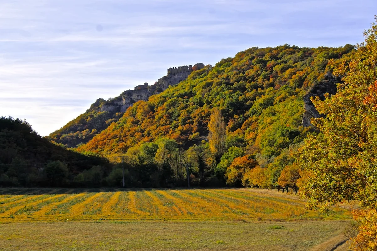
- Arrive at the spectacular ruins of the Château de Tonquédec, a 15th-century fortress
- Key Waypoint: The view of the castle towers emerging from the forest canopy
Day 3: Tonquédec to Belle-Isle-en-Terre
- Distance: 22 km
- Elevation gain: 550 m
- Time: 6–7 hours
- A day of deep forest immersion following the Guer and Léguer rivers
- Traverse the Forêt de Coat-an-Noz, an ancient woodland once owned by Breton nobility
- The terrain becomes more rugged with frequent short climbs
- Arrive in Belle-Isle-en-Terre, a charming town famous for its ironworking history
- Key Waypoint: The confluence of the Guer and Guic rivers in the town centre
Day 4: Belle-Isle-en-Terre to Bourbriac
- Distance: 20 km
- Elevation gain: 600 m
- Time: 6–7 hours
- Climb onto the higher plateaus of the Argoat
- Pass through the Forêt de Beffou, the highest forest in Brittany
- Views extend across the rolling hills of the Côtes-d'Armor on clear days
- Arrive in Bourbriac, a town with a significant religious heritage and a grand granite church
- Key Waypoint: The "Pavé de Beffou," a section of ancient Roman road within the forest
Day 5: Bourbriac to Quintin
- Distance: 25 km
- Elevation gain: 700 m
- Time: 7–8 hours
- The longest and most demanding day of the trek
- Cross the granite spine of the region, passing through remote farming hamlets
- The trail follows ancient "chemins creux" (sunken lanes) bordered by oak and hazel
- Arrive in the "Petite Cité de Caractère" of Quintin, famous for its two castles and linen history
- Key Waypoint: The megalithic menhirs of Kerpuns, standing in the fields near the trail
Day 6: Quintin to L'Hermitage-Lorge
- Distance: 18 km
- Elevation gain: 450 m
- Time: 5–6 hours
- A gentler day through a mix of pastureland and managed forest
- Enter the Forêt de Lorge, a vast woodland known for its deer population
- The trail is well-marked and follows wide forest tracks
- Arrive in the quiet village of L'Hermitage-Lorge
- Key Waypoint: The Pas de Saint-Hubert, a traditional hunting landmark in the forest
Day 7: L'Hermitage-Lorge to Mûr-de-Bretagne
- Distance: 22 km
- Elevation gain: 650 m
- Time: 6–7 hours
- The trail heads south towards the heart of the Breton lake district
- Pass through the village of Saint-Guen
- Approach the northern shores of Lake Guerlédan, the largest lake in Brittany
- Arrive in Mûr-de-Bretagne, a hilltop town overlooking the lake and the Blavet Valley
- Key Waypoint: The panoramic viewpoint over the Guerlédan Dam
Day 8: Mûr-de-Bretagne to Pontivy
- Distance: 20 km
- Elevation gain: 300 m
- Time: 5–6 hours
- Follow the Nantes-Brest Canal and the Blavet River
- The terrain is flatter but the scenery is lush and tranquil
- Pass through numerous canal locks, each with its own historic lock-keeper's cottage
- Arrive in Pontivy, a town with a dual identity: medieval streets and Napoleonic boulevards
- Key Waypoint: The Château des Rohan, a massive 15th-century fortress in Pontivy
Day 9: Pontivy to Baud
- Distance: 20 km
- Elevation gain: 400 m
- Time: 5–6 hours
- Continue south through the Blavet Valley, occasionally climbing the valley sides for views
- The landscape becomes more influenced by the milder climate of southern Brittany
- Pass through the village of Saint-Barthélemy
- Arrive in Baud, a town known for its "Venus of Quinipily," an ancient and mysterious stone statue
- Key Waypoint: The Chapel of Saint-Adrien, nestled in a bend of the river
Day 10: Baud to Final Destination (e.g., Pluvigner or Redon)
- Distance: 18–25 km (depending on final transport links)
- Elevation gain: 300 m
- Time: 5–7 hours
- The final push through the Landes de Lanvaux, a region of moorland and scattered granite outcrops
- The trail concludes in the southern Argoat, where the air begins to feel more maritime once again
- Finish at a major transport hub for the return journey to Brest or beyond
- Key Waypoint: The numerous megalithic sites scattered across the Lanvaux plateau
Planning and Bookings
Book Your Trip
Everything you need to plan your journey
Accommodation
Find places to stay near Brest
Flights
Search flights to Brest
Essential Preparation
The GR38 requires a moderate level of physical fitness. While there are no high-altitude challenges, the cumulative effect of walking 180 kilometres over 10 days with a pack is significant. Walkers should be comfortable with daily elevation gains of 400–700 metres. Training should include back-to-back days of walking on undulating terrain to condition the legs and feet for the "Breton sawtooth" profile.
Logistically, the GR38 is well-supported but requires careful coordination. The primary resource for the trail is the "Topoguide" published by the FFRandonnée (French Hiking Federation). This guide provides detailed 1:50,000 maps, water point locations, and accommodation listings. It is highly recommended to purchase the latest edition, as trail reroutes can occur. Brest is the most convenient logistical hub, offering an international airport and high-speed TGV train connections to Paris. From Brest, regional trains and buses connect to Lannion and the trailhead at Ploumanac'h.
Trail Accommodation
Accommodation on the GR38 is varied, ranging from rustic hikers' hostels to comfortable hotels. Because the trail passes through many small villages, you will have the opportunity to experience authentic Breton hospitality.
Types of Accommodation:
- Gîtes d'étape: These are specifically designed for hikers. They offer dormitory-style sleeping (bring a sleeping bag liner) and often have communal kitchens. Some provide "demi-pension" (dinner and breakfast). Costs: €20–€35 per night.
- Chambres d'hôtes: French Bed and Breakfasts. These offer a more private and comfortable experience, often in historic granite houses. Costs: €60–€100 per night.
- Hotels: Available in larger towns like Lannion, Quintin, and Pontivy. Costs: €70–€130 per night.
- Camping: There are municipal campsites in many villages along the route. Wild camping is generally discouraged and subject to local regulations; always seek permission if on private land.
Booking Requirements: During the peak months of July and August, it is essential to book accommodation at least 2–4 weeks in advance. In the shoulder seasons, 2–3 days' notice is usually sufficient, but always call ahead to ensure the gîte is open, as some operate on a seasonal basis.
Required Gear
- Footwear: Sturdy, waterproof hiking boots with good ankle support. The trail can be rocky in the granite sections and muddy in the forests. Ensure they are well broken-in.
- Rain Gear: A high-quality waterproof jacket (Gore-Tex or similar) and waterproof overtrousers. The Breton "crachin" can be very penetrating.
- Pack: A 35–50L backpack with a waterproof cover. A well-fitted hip belt is essential to distribute weight.
- Clothing: Layering is key. Use moisture-wicking base layers (merino wool is excellent), a fleece or insulated mid-layer, and quick-drying trekking trousers. Avoid denim.
- Navigation: The FFRandonnée Topoguide, a compass, and a GPS or smartphone with offline maps (e.g., IGN Rando app). While the trail is marked with red and white blazes, they can be obscured in dense forest or overgrown sections.
- Safety: A basic first aid kit (including blister pads/Compeed), a whistle, and a space blanket.
What to Bring
- Water: At least 2 litres of carrying capacity. While tap water in France is safe, water points can be sparse in the more remote sections of the Argoat.
- Food: Carry enough snacks (nuts, dried fruit, energy bars) for each day. Most villages have a "boulangerie" for fresh bread and a "supérette" (small supermarket) for lunch supplies, but check opening times as many close for lunch (12:30–14:30) and on Sundays/Mondays.
- Personal Items: Biodegradable soap/shampoo, a quick-dry towel, sun protection (sunscreen and hat), and insect repellent (ticks can be an issue in the forests).
- Electronics: A power bank for your phone, as charging points in older gîtes may be limited. A European plug adapter (Type C or E).
- Cash: Many small gîtes and village shops do not accept credit cards. Carry enough Euros to cover several days of expenses.
Permits
One of the great advantages of the GR38 is that no formal permits or registrations are required to walk the trail. It is a public right-of-way, open to all. However, there are several administrative and logistical considerations to keep in mind to ensure a smooth journey.
Access and Regulations:
- No Fees: There is no entry fee for the trail itself or for the regional parks it passes through.
- Hunting Season: In France, the hunting season ("la chasse") typically runs from September to February. During this time, it is important to stay on the marked trail and wear bright colours. Some forest sections may have specific warnings posted; always respect these.
- Group Size: While there is no limit on group size, large groups (more than 8–10 people) should contact gîtes well in advance to ensure they can be accommodated.
- Fishing: If you plan to fish in the rivers or canals (like the Blavet), you must purchase a French fishing permit ("carte de pêche"), available at local tobacco shops (Tabacs) or online.
Logistical Strategy:
- Transport: Use the "BreizhGo" website or app to plan bus and train travel within Brittany. It is an excellent resource for coordinating your arrival at Ploumanac'h and your departure from the southern end of the trail.
- Insurance: Ensure you have travel insurance that covers hiking and potential mountain/rural rescue. While the terrain is not extreme, accidents can happen in remote areas.
- Language: While many people in the tourism industry speak English, having a few basic French phrases will greatly enhance your experience in the smaller villages of the Argoat.
Other Activities in the Area
Brittany offers a wealth of experiences that can be easily combined with a GR38 trek:
- Pink Granite Coast Exploration: Spend an extra day in Ploumanac'h or Perros-Guirec to explore the coastal paths, visit the Seven Islands (Sept-Îles) bird sanctuary, or try sea kayaking among the granite islets.
- The Valley of the Saints (La Vallée des Saints): Located near Carnoët (not far from the trail), this is a unique project featuring dozens of monumental granite statues of Breton saints, often called the "Easter Island of Brittany."
- Cider Tasting: Brittany is world-famous for its cider. Visit a local "cidrerie" in the Cornouaille or Côtes-d'Armor regions to learn about the traditional fermentation process and sample different varieties.
- Medieval Architecture: Take time to explore the "Enclos Paroissiaux" (Parish Closes) in the nearby Finistère region, which feature some of the most elaborate stone carvings in Europe.
- Brest Maritime Heritage: Before or after your hike, visit Océanopolis in Brest, one of Europe's largest aquariums, or explore the historic naval dockyards and the Tanguy Tower.
- Canal Cycling: If your legs need a break from walking, the Nantes-Brest Canal offers excellent flat cycling paths that intersect with the GR38 near Pontivy.
Safety and Conditions
Pre-Departure Checks:
- Check the "Météo France" regional forecast for the Côtes-d'Armor and Morbihan departments.
- Consult the FFRandonnée Brittany website for any "alerte sentier" (trail alerts) regarding closures or diversions due to storm damage or forestry work.
- Ensure your mobile phone is fully charged and has the "My112" app installed for emergency location services.
Terrain Hazards: The primary hazards on the GR38 are related to the terrain and weather rather than extreme altitude. Be aware of slippery granite rocks and roots, especially after rain. The "chemins creux" can become very muddy and waterlogged, increasing the risk of slips and ankle strains. In the forested sections, be mindful of falling branches during high winds, which are common in Brittany.
Navigation: While the red and white blazes are generally excellent, they can be missed at complex junctions or in overgrown areas. Always carry a physical map and compass as a backup to digital tools. If you haven't seen a blaze for more than 200 metres, backtrack to the last known marker.
Ticks and Lyme Disease: Ticks are prevalent in the ferns and long grasses of the Breton forests and moorlands. Wear long trousers, use repellent, and perform a thorough tick check at the end of every day. Carry a tick removal tool in your first aid kit.
Water and Heat: Even in the mild Breton climate, dehydration is a risk. Drink regularly and carry enough water for the entire day, as public fountains in small villages are not always operational. During rare summer heatwaves, plan to walk early in the morning and rest during the hottest part of the day.
Emergency Contacts: The universal European emergency number is 112. Be prepared to give your location based on the nearest village or the specific GR38 stage and kilometre marker if known.
Side Trips and Points of Interest
Château de Tonquédec: This 15th-century fortress is one of the most impressive ruins in Brittany. Located just off the trail on Day 2, its eleven towers rise dramatically above the Léguer Valley. It is well worth the small entry fee to explore the ramparts and imagine the medieval history of the region.
The Forêt de Beffou: As the highest forest in Brittany, Beffou offers a unique ecosystem. Look for the "Pavé de Beffou," a remarkably well-preserved section of Roman road that once connected the ancient cities of Vorgium (Carhaix) and Lannion. The forest is also home to diverse birdlife and ancient beech trees.
Quintin - The Linen Town: Quintin is a "Petite Cité de Caractère" that feels like a film set. The town's wealth was built on the manufacture of fine linen ("toiles de Bretagne"), and the grand 18th-century houses of the linen merchants still line the streets. Visit the Château de Quintin and its gardens for a glimpse into the town's aristocratic past.
Lake Guerlédan: This 12-kilometre-long lake was created by the damming of the Blavet River in the 1920s. The trail offers several stunning viewpoints over the water. If you have extra time, the "Sentier de Rivage" (shoreline path) allows for a complete circuit of the lake, though this adds significantly to the distance.
The Venus of Quinipily: Located near Baud at the end of the trek, this mysterious 2.2-metre-tall stone statue has puzzled historians for centuries. Some believe it is an ancient Celtic deity, while others suggest it is a Roman or even Egyptian import. It sits in a beautiful garden and provides a fittingly enigmatic conclusion to the journey.
Leave No Trace
The GR38 passes through a variety of sensitive environments, including ancient woodlands, protected moorlands, and traditional agricultural land. As a walker, you are a guest in these landscapes and have a responsibility to minimise your impact.
Principles for the GR38:
- Stick to the Path: The "chemins creux" and forest trails are susceptible to erosion. Avoid cutting switchbacks or creating new paths, which can damage fragile root systems and soil structure.
- Waste Management: Pack out all rubbish, including organic waste like orange peels or apple cores, which can take a long time to decompose in the damp Breton climate and can attract scavengers.
- Respect Private Property: Much of the trail passes through or alongside private farmland. Always close gates behind you and keep dogs on a lead, especially near livestock.
- Water Protection: Do not use soap or detergents in the rivers or canals. Even biodegradable soaps can harm aquatic life in small streams.
- Fire Safety: Wildfires are a genuine risk in the gorse-covered moorlands and dry pine forests during summer. Never light open fires and be extremely careful with camping stoves.
- Flora and Fauna: Do not pick wildflowers or disturb wildlife. Brittany's forests are home to rare species of moss, lichen, and fungi that are easily damaged.
By following these principles, you help ensure that the GR38 remains a pristine and beautiful resource for future generations of walkers and for the local communities who maintain it.