France — Brest
Hike France's GR34, the Sentier des Douaniers, a 2100km moderate coastal route tracing Brittany's entire shoreline. This extensive path offers unparalleled Atlantic panoramas, from Mont Saint-Michel's salt marshes to Saint-Nazaire's port. Expect varied terrain and breathtaking sea views over 2-3 months.
Distance: 2100.0 km
Elevation Gain: 16750 m
Difficulty: Moderate
Duration: 2-3 months (for the complete trail)
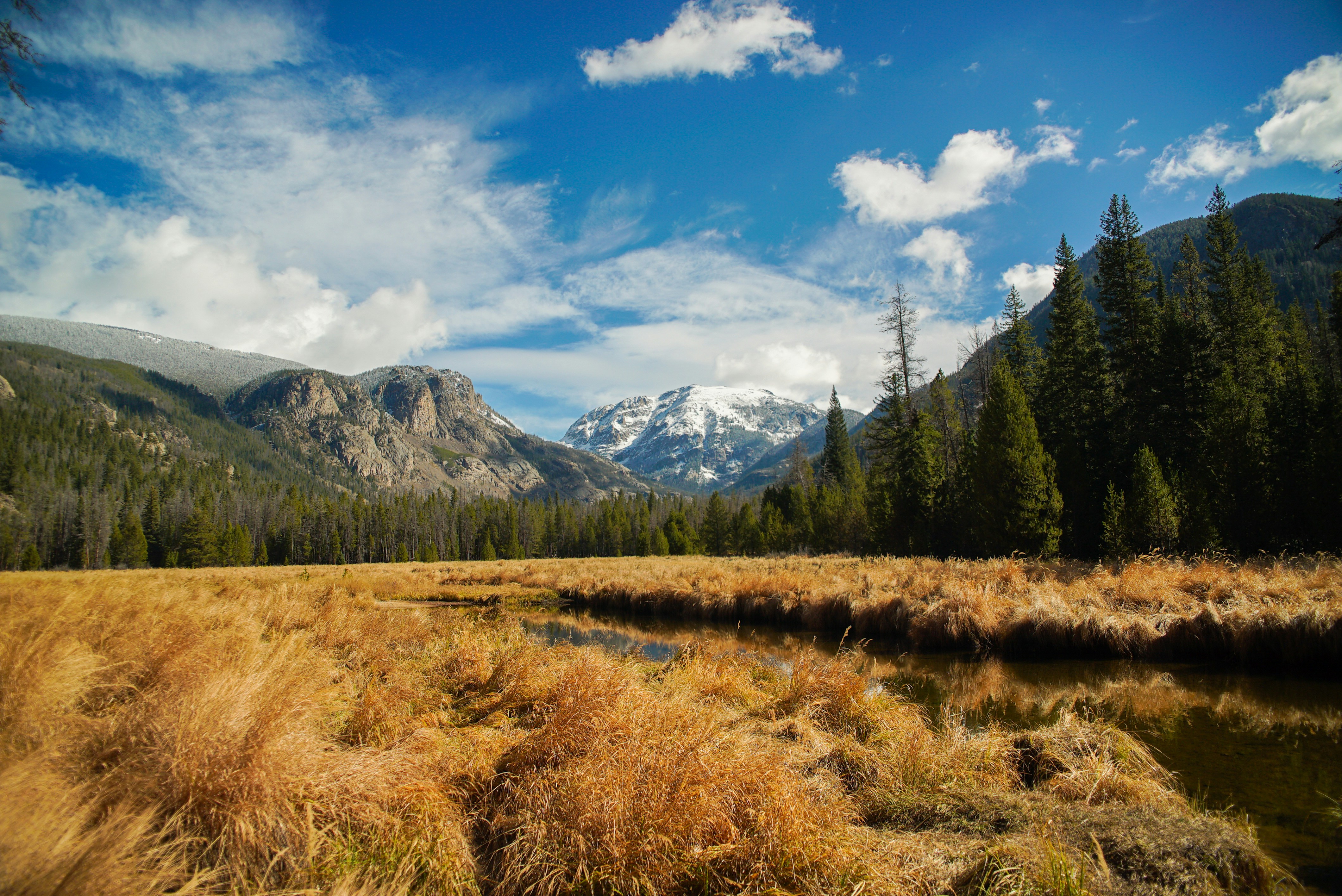
The GR34, famously known as the "Sentier des Douaniers" (Customs Officers' Path), is one of France's most iconic and extensive long-distance trekking routes. Stretching over 2,100 kilometres, it traces the entirety of the Brittany coastline, from the mystical salt marshes of Mont Saint-Michel in the north to the industrial yet atmospheric port of Saint-Nazaire in the south. This trail is a masterclass in maritime diversity, offering walkers an unbroken view of the Atlantic Ocean, the English Channel, and the rugged, granite-hewn shores that define the Breton identity. Originally established in the 18th century to allow customs officers to patrol the coast and intercept smugglers, the path was revitalised in the late 1960s as a recreational trail. Today, it serves as a profound journey through ancient Celtic history, dramatic geological formations, and some of the most pristine coastal ecosystems in Europe.
The GR34 is not merely a hike; it is an immersion into the soul of Brittany. Voted "France's Favourite GR" multiple times, the route offers a landscape that shifts with every tide. The trail is defined by its proximity to the sea—at almost no point are you more than a few hundred metres from the salt spray. The terrain varies from the towering, jagged cliffs of the Finistère "End of the World" to the gentle, turquoise-watered coves of the Gulf of Morbihan. Walkers will traverse the Emerald Coast, the Pink Granite Coast, the Iroise Sea, and the rugged Cornouaille region, each offering a distinct geological and cultural flavour.
The experience of the GR34 is dictated by the elements. Brittany’s weather is legendary for its variability; it is often said that one can experience all four seasons in a single afternoon. The wind is a constant companion, shaping the stunted oak trees and gorse bushes that line the cliffs. However, when the sun breaks through, the clarity of the light is extraordinary, illuminating the "Côte de Granit Rose" in shades of copper and blush, or turning the waters of the Glénan archipelago into a Caribbean-esque turquoise. The trail is well-marked with the characteristic red-and-white blazes of the French Grande Randonnée network, making navigation straightforward even in the misty conditions that occasionally roll in from the Atlantic.
Culturally, the GR34 is a journey through a land of legends. You will pass prehistoric menhirs and dolmens, medieval fortresses like Fort La Latte, and countless stone chapels dedicated to local saints. The maritime heritage is equally present, with hundreds of lighthouses—some of the most powerful in the world—guarding the treacherous reefs of the Iroise Sea. For the modern trekker, the trail provides a unique logistical advantage: it passes through dozens of charming fishing villages and historic ports, ensuring that a fresh galette, a bowl of local cider, or a plate of world-class oysters is never far away. Whether you tackle the entire 2,100 km odyssey or focus on a specific 100 km stretch, the GR34 offers a sense of freedom and connection to the sea that is unmatched by any other coastal path in Europe.
The origins of the GR34 are rooted in the turbulent history of 18th-century European trade and warfare. In 1791, following the French Revolution, the "Administration des Douanes" (Customs Administration) was formalised. To combat the rampant smuggling of tobacco, salt, and textiles—largely orchestrated by English merchants and local Breton sailors—a continuous path was cleared along the coastline. This allowed customs officers, or "douaniers," to patrol the shore day and night, regardless of the weather. They lived in small stone watch-houses (corps de garde) dotted along the cliffs, many of which still stand today as silent witnesses to this era of maritime espionage.
For over a century, the path was the exclusive domain of these officers, who walked thousands of kilometres every year in heavy woollen coats and wooden clogs. However, as transport technology improved and smuggling methods shifted to the high seas, the coastal path fell into disuse and was reclaimed by gorse and brambles. It wasn't until 1968 that the path was "rediscovered" by hiking enthusiasts. Émile Orain, a passionate walker from Saint-Brieuc, led a group of volunteers to clear the first recreational section near Beg-Léguer. This marked the birth of the modern GR34. Over the following decades, the French Hiking Federation (FFRandonnée) worked tirelessly with local municipalities and private landowners to reconnect the fragmented sections, eventually creating the continuous 2,100 km loop we see today.
The cultural context of the trail is deeply Breton. Brittany (Breizh) has a distinct identity, separate from the rest of France, with its own language, music, and traditions. The GR34 passes through the "Pays Bigouden," known for its tall lace headdresses, and the "Léon" region, famous for its maritime prowess. The trail is also a pilgrimage route of sorts; it connects many of the sites associated with the "Tro Breizh," a medieval pilgrimage around the seven founding cathedrals of Brittany. Walking the GR34 is, therefore, an act of historical exploration, tracing the footsteps of both the law-enforcers of the 18th century and the Celtic saints of the 5th century.
Want more background? Read extended notes on history and cultural context → Learn more
Brittany’s climate is oceanic, meaning it is temperate but highly unpredictable. Choosing the right time to walk the GR34 is crucial for both comfort and safety. While the trail is technically open year-round, the experience varies dramatically between the seasons.
Spring (April to June): This is arguably the best time to hike the GR34. The coastal flora is in full bloom, with yellow gorse and pink thrift (armeria maritima) carpeting the cliffs. The days are lengthening, and the temperatures are mild, typically ranging from 12°C to 18°C. Birdwatchers will find this season particularly rewarding, as thousands of seabirds return to the cliffs of Cap Fréhel and the Sept-Îles archipelago to nest. While rain is still possible, the air is often crisp and clear.
Summer (July and August): This is the peak tourist season. The weather is at its warmest (20°C to 25°C), and the sea is inviting for a post-hike swim. However, the trail can become crowded, particularly around popular landmarks like the Pink Granite Coast or the Crozon Peninsula. Accommodation must be booked months in advance, and prices are at their highest. The "Meltem" (strong winds) can occasionally provide a cooling breeze, but the sun can be intense on the exposed cliff tops.
Autumn (September to October): September is a "golden month" in Brittany. The summer crowds have dispersed, the sea remains warm enough for swimming, and the light takes on a soft, autumnal quality that is a favourite for photographers. Temperatures remain pleasant (15°C to 20°C). By October, the weather becomes more volatile, with the first of the Atlantic storms potentially bringing high winds and heavy rain, but the dramatic seascapes are spectacular.
Winter (November to March): Hiking the GR34 in winter is only for the hardy. Many gîtes and campsites close, and the days are short and often grey. However, for those seeking true solitude and the raw power of the ocean, winter offers a unique perspective. The "Grandes Marées" (spring tides) in Saint-Malo are a sight to behold, with waves crashing over the sea walls. Proper waterproof gear and flexible plans are essential, as certain cliff sections may be closed during high-wind alerts.
Day 1: Mont Saint-Michel to Cancale
Day 2: Cancale to Saint-Malo
Day 3: Saint-Malo to Saint-Jacut-de-la-Mer
Day 4: Saint-Jacut-de-la-Mer to Cap Fréhel
Day 5: Cap Fréhel to Erquy
Day 6: Erquy to Pléneuf-Val-André
Day 7: Pléneuf-Val-André to Saint-Brieuc
Day 8: Saint-Brieuc to Binic
Day 9: Binic to Paimpol
Day 10: Paimpol to Lézardrieux (via Sillon de Talbert)
Day 11: Lézardrieux to Tréguier
Day 12: Tréguier to Perros-Guirec
Day 13: Perros-Guirec to Ploumanac'h (The Pink Granite Highlight)
Day 14: Ploumanac'h to Trébeurden
Important Notes:
Planning a trip on the GR34 requires a balance between ambition and realism. Because the trail is 2,100 km long, most hikers choose a specific section (typically 100–200 km) to complete over a week or two. Fitness requirements are moderate; while there are no high-altitude climbs, the constant "yo-yo" of descending to beaches and climbing back to cliff tops can be taxing on the knees and calves. A baseline of walking 15–20 km per day with a pack is recommended.
Brest serves as the primary logistical hub for the western sections (Finistère), while Saint-Malo and Saint-Brieuc are ideal for the northern sections. The French rail network (SNCF) and the regional "BreizhGo" bus system are exceptionally well-integrated, allowing hikers to reach almost any trailhead. It is highly recommended to purchase the official "Topoguides" published by FFRandonnée; these pocket-sized books provide detailed 1:25,000 maps, historical context, and up-to-date lists of accommodation and services.
The GR34 offers a wide variety of accommodation, but the density varies by region. In popular areas like the Emerald Coast, you will find an abundance of options, whereas the wilder stretches of northern Finistère require more careful planning.
Types of Accommodation:
Booking Requirements:
One of the greatest joys of the GR34 is its accessibility. There are no permits required to walk the trail, and there are no entry fees for the path itself. The "Sentier des Douaniers" is a public right of way, protected by French law (the "servitude de passage transversal"), which ensures that the public has access to a strip of land along the entire coastline, even where it passes through private property.
Key Regulations:
Logistical Costs: While the trail is free, you should budget for the "Malle Postale" if you wish to have your luggage transferred between accommodations (approx. €15 per bag, per stage). This service is highly efficient and allows you to walk with only a day pack.


Precisely traced GPX for the Gr34, ready for your GPS or favourite mapping app.
Brittany offers a wealth of experiences that complement a hiking trip on the GR34:
Tidal Awareness: This is the most critical safety factor on the GR34. Brittany has some of the highest tidal ranges in Europe (up to 14 metres in the Bay of Mont Saint-Michel). Some sections of the trail cross beaches or estuaries that are completely submerged at high tide. Always check the "Annuaire des Marées" (tide timetable) before setting out. Never attempt to cross an estuary if the tide is rising.
Cliff Erosion: The Breton coastline is constantly being reshaped by the Atlantic. After heavy rain or winter storms, sections of the cliff path can become unstable. Always respect "Sentier Barré" (Path Closed) signs and follow the official inland diversions (déviations). Never stand near the edge of a cliff, especially in high winds.
Weather Alerts: Météo-France issues colour-coded alerts (Yellow, Orange, Red). If an "Orange" alert for wind (vent violent) or coastal flooding (vagues-submersion) is issued, it is strongly advised to stay off the coastal path and move inland. Wind gusts on headlands like the Pointe du Raz can exceed 100 km/h during storms.
Navigation in Fog: Sea fog (brume de mer) can descend rapidly, reducing visibility to a few metres. While the trail is well-marked, it is easy to lose the red-and-white blazes in thick fog. Carry a compass or a GPS with offline maps and be prepared to wait for the fog to lift if you are in a precarious cliff section.
Emergency Services: The universal European emergency number is 112. In the event of a maritime emergency (e.g., being cut off by the tide), you can also call 196 to reach the CROSS (Regional Operational Centres for Surveillance and Rescue).
The Crozon Peninsula: Often considered the most beautiful section of the GR34, this cross-shaped peninsula in Finistère offers Mediterranean-style scenery with Atlantic power. The Cap de la Chèvre features 100-metre cliffs overlooking the Bay of Douarnenez, while the Pointe de Pen-Hir is home to the "Tas de Pois" (Heaps of Peas), a series of massive sea stacks. The turquoise waters of L'Île Vierge (actually a peninsula) are frequently cited as having the most beautiful beach in Europe.
The Abers of Northern Finistère: The "Abers" are deep, fjord-like inlets where the sea flows far inland. The Aber Wrac'h, Aber Benoit, and Aber Ildut offer a change of pace from the rugged cliffs, with tranquil wooded shorelines, ancient stone bridges, and oyster beds. This area is the heart of "Lighthouse Country," with the Phare du Four and Phare de l'Île Vierge dominating the horizon.
The Gulf of Morbihan: In the south, the GR34 circles this "Little Sea" (Mor-Bihan in Breton). It is a vast inland sea dotted with dozens of islands. The path here is flatter and more sheltered, passing through salt marshes and past megalithic sites. The tidal currents at the entrance to the gulf are among the strongest in Europe, creating a fascinating spectacle of swirling water.
The Côte d'Émeraude (Emerald Coast): Named for the stunning green hue of the water, this section between Cancale and Cap Fréhel combines high-society resort towns like Dinard with wild, bird-filled cliffs. The Fort La Latte is a mandatory stop; this 14th-century castle has been used as a filming location for numerous films, including "The Vikings" starring Kirk Douglas.
The GR34 passes through some of France's most fragile coastal environments. The dunes, salt marshes, and cliff-top heaths are home to rare species like the Dartford warbler and the Atlantic grey seal. With over 9 million people walking sections of the GR34 annually, the cumulative impact is significant.
Your responsibility as a walker:
By following these principles, you ensure that the "Sentier des Douaniers" remains a wild and beautiful sanctuary for the next generation of walkers.