GR3 Trail - The Grand Traverse of the Iberian Heartland
The GR3 Trail is one of Spain’s most ambitious and evocative long-distance walking routes, stretching across a staggering 595 kilometres of diverse and often overlooked landscapes. While many international walkers flock to the Camino de Santiago, the GR3 offers a more rugged, solitary, and culturally immersive experience through the mountainous interior of the Iberian Peninsula. Starting near the historic town of Yeste in the province of Albacete, the trail weaves through the dramatic Sierra de Segura before striking out across the high plateaus and hidden valleys of central Spain. This is a journey of nearly 15,000 metres of cumulative elevation gain, demanding a high level of physical endurance and mental fortitude over a period of 25 to 30 days. It is a route that avoids the commercialised corridors of modern tourism, instead favouring the "España Vaciada" (Empty Spain)—regions where ancient traditions, medieval architecture, and vast, silent horizons remain the primary features of the landscape.
- Distance: 595.0 km one-way
- Duration: 25–30 days
- Season: Spring (April–June) and Autumn (September–October)
- Total Elevation Gain: 15,000 m
- Difficulty: Moderate to Strenuous (due to distance and isolation)
- Closest City: Madrid (access via Yeste)
- Terrain: Mountainous tracks, ancient transhumance routes, limestone canyons, and high-altitude plateaus
Overview
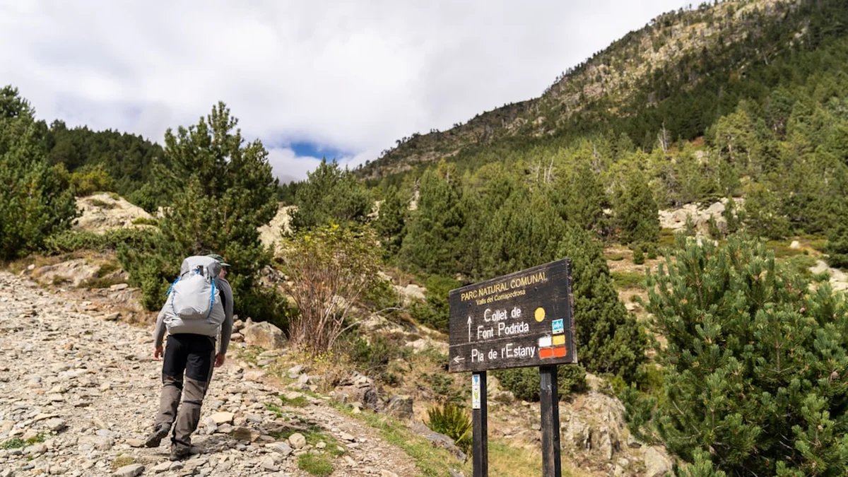
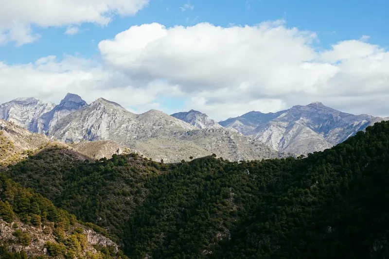
The GR3 Trail is a masterclass in geographical transition. It begins in the southern reaches of the Prebaetic System, where the limestone crags of the Sierra de Segura provide a dramatic, vertical introduction to the trek. Here, the landscape is defined by deep river canyons, turquoise reservoirs, and dense forests of Aleppo and black pine. As the trail progresses north and west, the verticality of the mountains gives way to the undulating "meseta"—the high central plateau of Spain. This transition is not merely physical but atmospheric; the air becomes drier, the light more intense, and the sense of space almost overwhelming. The route is designed to connect isolated mountain villages, many of which appear frozen in the era of the Reconquista, with their stone fortresses and narrow, winding streets designed to provide shade from the relentless Iberian sun.
Walking the GR3 is an exercise in solitude. Unlike the more popular coastal routes, you may go days without seeing another hiker. The rhythm of the trail is dictated by the availability of water and the distance between villages. You will traverse "dehesas"—ancient oak parklands where Iberian pigs roam—and cross "cañadas reales," the historic migratory paths used for centuries by shepherds moving their flocks between summer and winter pastures. The geology is equally varied, ranging from the karst formations of the southern sierras to the red clay soils and granite outcrops of the central plains. This is a landscape that requires the walker to be self-sufficient and observant, as the trail markings (the red and white stripes of a Gran Recorrido) can sometimes be weathered or obscured by the very wilderness they seek to navigate.
The emotional core of the GR3 lies in its silence. In a world that is increasingly connected and noisy, the vast stretches of the Albacete and Castile-La Mancha hinterlands offer a rare opportunity for reflection. The scale of the 595-kilometre journey allows for a total immersion in the environment. You will witness the slow change of vegetation as you climb from 500 metres to nearly 2,000 metres, and you will experience the legendary hospitality of rural Spain, where a tired walker is often greeted with genuine curiosity and warmth. This is not just a hike; it is a pilgrimage through the soul of the Spanish interior, challenging your legs with its climbs and rewarding your spirit with its timeless beauty.
History and Cultural Context
The GR3 Trail follows a corridor that has been a crossroads of civilisations for millennia. Long before it was formalised as a hiking route, these paths were used by Roman legionaries, Moorish caliphates, and Christian knights. The starting point near Yeste is dominated by its 13th-century castle, a fortress that once stood on the volatile frontier between the Kingdom of Castile and the Moorish Kingdom of Granada. The architecture of the region—a blend of Gothic, Mudéjar, and Renaissance styles—tells the story of a land that was fought over for centuries. As you walk, you will encounter "atalayas" (watchtowers) perched on distant ridges, remnants of a sophisticated medieval signalling system that once protected these valleys from invasion.
Crucial to the identity of the GR3 are the "Cañadas Reales." These are the royal sheep-droving tracks that were protected by the "Mesta," a powerful association of sheep owners established in the 13th century. For hundreds of years, millions of Merino sheep were moved along these wide, grassy corridors, shaping the ecology and the economy of the Spanish heartland. Walking the GR3 means walking in the footsteps of these nomadic shepherds. The trail also passes through areas of significant Roman influence, where ancient bridges still span seasonal rivers and the remains of villas lie hidden beneath olive groves. The cultural heritage is not just found in the monuments, but in the "pueblos" themselves, where the local dialects, culinary traditions (such as "gazpacho manchego" and "migas"), and the slow pace of life reflect a deep-seated connection to the land.
In the 20th century, many of these regions suffered from "exodo rural" (rural exodus), as younger generations moved to cities like Madrid and Valencia. The GR3 serves as a vital link to these "emptied" lands, encouraging sustainable tourism that supports local economies. By walking this trail, you are participating in the preservation of a way of life that is increasingly fragile. The trail is a living museum, where every stone wall and irrigation channel has a story to tell about the resilience of the people who have inhabited this beautiful, harsh environment for generations.
Want more background? Read extended notes on history and cultural context → Learn more
Seasonal Highlights and Weather Reality
Timing is the most critical factor when planning a 600-kilometre trek across Spain. The interior of the peninsula is known for its "clima continental"—extreme temperatures that can swing from freezing to scorching within a few weeks. The ideal windows are Spring (April to June) and Autumn (September to October). During these months, the temperatures are generally mild, ranging from 10°C at night to 25°C during the day, providing the most comfortable conditions for high-mileage days.
Spring is arguably the most beautiful time to walk the GR3. The "meseta," which can be a parched brown for much of the year, erupts in a carpet of wildflowers—poppies, lavender, and rockrose. The rivers are full from the winter snowmelt in the sierras, and the air is filled with the scent of blossoming almond and cherry trees. However, Spring can also bring "tormentas" (thunderstorms), particularly in the afternoons, which can turn the clay paths into heavy mud. Autumn offers a different but equally compelling palette. The vineyards of the central plains turn deep shades of gold and crimson, and the heat of the summer begins to fade, replaced by crisp mornings and clear, stable skies. This is also the season of the harvest, and the villages are often alive with local festivals.
Summer (July and August) should be avoided by all but the most heat-hardened walkers. Temperatures regularly exceed 40°C, and shade is non-existent on the long stretches of the plateau. Water sources that are reliable in Spring often dry up completely in August, making the logistics of a 30-day trek dangerous. Conversely, Winter (November to March) brings the risk of heavy snow in the Sierra de Segura and biting winds across the meseta. While the lower sections remain walkable, the high passes can become treacherous, and many small-town guesthouses close for the season. For a successful crossing, the temperate stability of the shoulder seasons is essential.
Recommended Itinerary
30-Day GR3 Trail Itinerary
Days 1–5: The Sierra de Segura Gateway
- Distance: 95 km
- Elevation: 3,200 m gain
- Key Waypoints: Yeste, Rio Mundo Valley, Riópar, Siles
- The journey begins with a steep ascent from Yeste into the heart of the Segura mountains.
- Visit the "Nacimiento del Río Mundo," a spectacular waterfall bursting from a cave wall.
- Terrain is rugged, with limestone paths and dense pine forests.
- Expect significant vertical gain as you cross the high ridges separating Albacete from Jaén.
Days 6–10: The Transition to the High Plateau
- Distance: 105 km
- Elevation: 2,100 m gain
- Key Waypoints: Alcaraz, Vianos, Robledo
- The trail leaves the high peaks and enters the Sierra de Alcaraz.
- Alcaraz is a highlight, with its stunning Renaissance Plaza Mayor and twin towers.
- The landscape begins to open up into wide valleys and rolling hills.
- Walking becomes faster as the gradients level out, though the distances between water sources increase.
Days 11–15: The Heart of La Mancha
- Distance: 110 km
- Elevation: 1,200 m gain
- Key Waypoints: El Bonillo, Munera, Villarrobledo
- This is the classic Quixotic landscape—vast horizons, windmills, and endless vineyards.
- The path follows ancient "cañadas" (sheep tracks) across the flat meseta.
- Navigation requires focus as the landscape can be repetitive; GPS is essential here.
- Villarrobledo offers a chance to resupply in a larger town known for its tinajas (giant clay wine jars).
Days 16–20: The Canyons and River Valleys
- Distance: 90 km
- Elevation: 2,500 m gain
- Key Waypoints: Ruidera Lakes, Ossa de Montiel, Argamasilla de Alba
- The trail passes the Lagunas de Ruidera, a series of fifteen interconnected lakes forming a turquoise oasis in the dry plains.
- Explore the Cave of Montesinos, famously mentioned in Miguel de Cervantes' Don Quixote.
- The terrain becomes more broken, with small canyons and river crossings.
- Wildlife sightings are common here, including eagles and Iberian ibex.
Days 21–25: The Western Sierras
- Distance: 100 km
- Elevation: 3,500 m gain
- Key Waypoints: Puerto Lápice, Consuegra, Los Yébenes
- The trail climbs back into the mountains, specifically the Montes de Toledo.
- Consuegra provides one of the most iconic views in Spain: a row of white windmills standing guard next to a medieval castle.
- The climbs are short but steep, testing tired legs after three weeks on the trail.
- The vegetation shifts to Mediterranean scrub—cistus, rosemary, and holm oak.
Days 26–30: The Final Approach
- Distance: 95 km
- Elevation: 2,500 m gain
- Key Waypoints: San Pablo de los Montes, Hontanar, Navahermosa
- The final stretch traverses the rugged heart of the Montes de Toledo.
- This is one of the wildest sections of the trail, with very few inhabitants and vast estates.
- The trail concludes in the foothills, offering views back toward the high peaks and forward toward the Tagus River valley.
- Finish the journey with a sense of immense achievement, having crossed the central spine of Spain.
Important Notes:
- This is a long-distance trek; rest days should be factored in every 7–10 days.
- Water management is the primary challenge; always carry at least 3 litres.
- Accommodation in smaller villages may require calling ahead to ensure someone is there to open the "hostal."
- The trail is marked with red and white paint, but these can be faded; always carry digital and paper maps.
- Siesta culture is real—shops in small villages will close between 14:00 and 17:00.
Planning and Bookings
Book Your Trip
Everything you need to plan your journey
Accommodation
Find places to stay near Madrid
Flights
Search flights to Madrid
Essential Preparation
The GR3 is not a trail for the casual weekend hiker. It requires a high level of physical fitness and, more importantly, the ability to manage logistics in a region where English is rarely spoken and services are sparse. Before starting, you should be comfortable walking 20–25 kilometres per day with a 10–12 kilogram pack for multiple consecutive days. Training should include significant elevation work to prepare for the 15,000 metres of total gain.
Logistically, the trail begins near Yeste. The most common approach is to fly into Madrid (MAD) and take a long-distance bus (ALSA or similar) to Hellín or Albacete, followed by a local bus or taxi to Yeste. Because the trail is linear and nearly 600 kilometres long, you must plan your return transport from the finish point (near Navahermosa/Toledo) back to Madrid. It is highly recommended to learn basic Spanish phrases related to food, water, and accommodation, as this will significantly improve your experience in the rural "pueblos."
Trail Accommodation
Accommodation on the GR3 is a mix of small-town "pensiones," "hostales," and the occasional "refugio" (mountain shelter). In the larger towns like Alcaraz or Villarrobledo, you will find comfortable hotels. In the smaller villages, you may be staying in a "Casa Rural" (rural guesthouse).
Accommodation Types:
- Hostales/Pensiones: Basic, clean rooms, usually with a shared or private bathroom. Costs range from €25 to €50 per night.
- Casas Rurales: Often beautifully restored stone houses. These are more expensive (€60–€100) but offer a high level of comfort and local character.
- Refugios: In the Sierra de Segura, there are a few basic mountain shelters. Some are "guardados" (staffed with meals) in peak season, while others are "vivacs" (unstaffed stone huts).
- Wild Camping: Technically restricted in many parts of Spain, especially in National Parks. However, in the "España Vaciada," it is often tolerated if you are discreet, set up at dusk, leave at dawn, and follow strict Leave No Trace principles. Always check local provincial regulations.
What's Provided: Most paid accommodation provides bedding and towels. In "refugios," you will need your own sleeping bag. WiFi is common in towns but non-existent in the mountains.
Required Gear
- Footwear: High-quality trekking boots or heavy-duty trail runners. The terrain is rocky and abrasive; ensure they are well broken-in.
- Pack: A 50–60 litre backpack with a high-quality suspension system. A rain cover is essential.
- Navigation: A dedicated GPS device or a smartphone with offline maps (e.g., Gaia GPS, Wikiloc). Carry a power bank (20,000mAh) as charging opportunities can be 48 hours apart.
- Clothing: A layering system is vital. Include a moisture-wicking base layer, a fleece or down mid-layer, and a high-quality waterproof/breathable shell.
- Sun Protection: A wide-brimmed hat, high-SPF sunscreen, and polarised sunglasses. The Iberian sun is intense, even in April.
- Emergency Gear: A basic first aid kit (focus on blister care), a multi-tool, and an emergency whistle.
What to Bring
- Water Treatment: A lightweight filter (e.g., Sawyer Squeeze) or purification tablets. While tap water in villages is safe, you will often need to draw from springs (fuentes) or streams.
- Food: Carry at least 2 days of emergency rations (dehydrated meals, nuts, energy bars). While you pass through villages, shops may be closed for siesta or local holidays.
- Cooking System: A lightweight stove (Jetboil or MSR Pocket Rocket) and a small fuel canister. Note: Gas canisters can be hard to find in small villages; buy them in Madrid or Albacete.
- Toiletries: Biodegradable soap, a quick-dry towel, and a "trowel" for waste management in the wild.
- Cash: Many small village bars and guesthouses do not accept credit cards. Carry at least €200–€300 in small denominations.
Permits
For the majority of the GR3 Trail, no formal permits are required for individual walkers. The trail passes through public land, livestock routes, and regional parks that are open to the public. However, there are specific regulations you must be aware of to ensure a legal and hassle-free journey.
Regional Park Regulations: When passing through protected areas like the Calares del Mundo y de la Sima Natural Park or the Cabañeros National Park (near the end of the route), strict rules apply. You must stay on the marked trails. In National Parks, wild camping is strictly prohibited, and you must stay in designated accommodation or campsites. If you are travelling in a large organised group (usually more than 10 people), you may need to notify the regional environmental office (Consejería de Desarrollo Sostenible) in Albacete or Toledo.
Hunting Season: This is a critical "permit" of a different kind. Much of the land the GR3 crosses is private hunting estate ("coto de caza"). Hunting season typically runs from October to February. During this time, it is essential to stay on the marked GR3 path. If you see signs saying "Montería" or "Cacería," it means an active hunt is taking place. Usually, the GR3 is kept clear, but it is wise to wear high-visibility clothing during the autumn months.
Fire Restrictions: From June 1st to September 30th, lighting any fire (including camping stoves in some areas) is strictly prohibited across most of rural Spain due to the extreme risk of forest fires. During this period, you should rely on cold food or only use stoves in designated picnic areas with stone pits.
Other Activities in the Area
If you have extra time or want to take a "zero day" (rest day), the regions surrounding the GR3 offer several world-class attractions:
- Toledo: Located near the end of the trail, this UNESCO World Heritage city is the "City of Three Cultures." Spend a day exploring its cathedral, synagogues, and mosques.
- Albacete Knife Museums: The city of Albacete is world-famous for its traditional cutlery. The Museo de la Cuchillería is a fascinating stop for those interested in traditional crafts.
- Wine Tasting in Valdepeñas: Just off the trail route, this region produces some of Spain’s most famous red wines. Many "bodegas" offer tours and tastings.
- Bird Watching in Cabañeros: Known as the "Spanish Serengeti," this National Park is one of the best places in Europe to see the Iberian Imperial Eagle and the Black Vulture.
- Starlight Tourism: The Sierra de Segura and the Montes de Toledo are certified Starlight Destinations. The lack of light pollution makes for some of the best stargazing in Europe.
Safety and Conditions
Heat and Hydration: The single greatest danger on the GR3 is heatstroke and dehydration. On the meseta, there can be 20-kilometre stretches with no shade and no water. You must monitor your hydration levels constantly. If you stop sweating or feel dizzy, find shade immediately and rest. Always carry more water than you think you need.
Livestock Guardian Dogs: As you cross the "cañadas" and "dehesas," you will encounter large flocks of sheep or goats protected by Mastines (Spanish Mastiffs). These dogs are bred to protect the flock from wolves and can be very intimidating. If you encounter them, do not run. Walk slowly, keep your distance from the flock, and do not make eye contact or aggressive gestures. Usually, they will bark until you have passed their "territory."
Flash Floods: In the limestone canyons of the Sierra de Segura, sudden afternoon thunderstorms in Spring can cause dry riverbeds (arroyos) to fill with water in minutes. Never camp in a dry riverbed, and be cautious of crossing deep water after heavy rain.
Isolation: Many sections of the GR3 are extremely remote. Mobile phone signal is inconsistent. It is highly recommended to carry a Satellite Messenger (like a Garmin inReach or Zoleo) so you can contact emergency services (112) if you suffer an injury in a "dead zone."
Insects and Snakes: While not a major threat, be aware of the Processionary Caterpillar in pine forests during Spring (their hairs are highly irritating) and the Lataste's Viper in rocky areas. Wear long trousers and watch where you step.
Side Trips and Points of Interest
The Source of the Rio Mundo (Los Chorros): A short detour from the main trail near Riópar. The river emerges from a massive cave in a cliff face, falling 80 metres into a series of pools. After heavy rain, a phenomenon called "El Reventón" occurs, where the water pressure inside the cave system causes a massive, explosive increase in the waterfall's flow.
The Windmills of Consuegra: While the trail passes through the town, it is worth spending several hours on the "Calderico" ridge. These twelve windmills are among the best-preserved in Spain and offer the quintessential "Don Quixote" experience. One of the windmills, "Bolero," is still functional and occasionally used for demonstrations.
Alcaraz Renaissance Architecture: Take time to explore the Calle Mayor in Alcaraz. The work of architect Andrés de Vandelvira is visible everywhere, and the town feels like a film set from the 16th century. The view from the ruins of the San Ignacio castle over the surrounding mountains is spectacular at sunset.
The Peñarrubia Reservoir: Near the start of the trail, this turquoise lake offers a chance for a swim in the early stages of the trek. The surrounding limestone cliffs are popular with rock climbers and offer great vantage points for spotting griffon vultures.
Leave No Trace
The GR3 passes through some of the most pristine and least-visited parts of Spain. Maintaining this wilderness character is the responsibility of every walker. The "España Vaciada" is a fragile ecosystem where water is scarce and fire is a constant threat.
Core Principles for the GR3:
- Fire Safety: Never light an open fire. Use a contained gas stove only in safe areas, and be aware of seasonal bans. A single spark can devastate thousands of hectares of dehesa.
- Waste Management: Pack out all trash, including organic waste like orange peels or apple cores, which decompose slowly in the arid climate. Use a trowel to bury human waste at least 20 centimetres deep and 60 metres from any water source.
- Respect Private Property: Much of the trail crosses private estates. Stay on the marked path, close all gates behind you, and do not disturb livestock.
- Water Conservation: Do not use soap (even biodegradable) directly in streams or village fountains. Collect water and wash at least 30 metres away from the source.
- Protect Heritage: Do not remove stones from ancient walls or "atalayas." These structures are part of the historical record of the region.