
GR247: Bosques del Sur - The Southern Forests Trail
The GR247, also known as the "Bosques del Sur" or Southern Forests Trail, is a monumental long-distance walking route traversing the vast and ancient forests of the Sierra de Cazorla, Segura y Las Villas Natural Park in Andalusia, Spain. This challenging trek offers an immersive journey through one of Europe's most significant Mediterranean forest ecosystems, a landscape rich in biodiversity, history, and dramatic natural beauty. Spanning an impressive 568 kilometres and demanding an elevation gain of approximately 18,000 metres, the GR247 is designed for experienced hikers seeking a profound connection with nature and a true test of endurance.
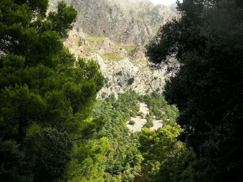
The trail winds through a mosaic of pine forests, oak woodlands, and scrubland, revealing hidden valleys, crystal-clear rivers, and panoramic mountain vistas. It passes through remote villages, ancient shepherd tracks, and areas steeped in the history of charcoal burning and traditional forest management. The GR247 is not merely a walk; it is an expedition into the heart of a wild and untamed landscape, offering solitude, spectacular scenery, and a deep appreciation for the resilience of nature.
- Distance: 568 km one-way
- Duration: 27–30 days
- Season: Spring (April–June) and Autumn (September–October)
- Difficulty: Challenging
- Highest point: Varies significantly, with numerous ascents and descents over 1,500 metres
- Accommodation: Rural guesthouses, refuges, and wild camping (where permitted)
- Direction: Typically walked from north to south, but can be done in sections or reverse
Overview
The GR247 is a true wilderness experience, a circular or linear route (depending on interpretation and access points) that circumnavigates or traverses the extensive forested massifs of the Sierra de Cazorla, Segura y Las Villas. This park is the largest protected area in Andalusia and a vital ecological corridor, home to a remarkable array of flora and fauna, including Iberian ibex, wild boar, deer, golden eagles, and even the elusive Iberian lynx. The trail's design ensures a deep immersion into these diverse forest types, from the towering black pines (Pinus nigra) that dominate the higher altitudes to the holm oaks (Quercus ilex) and gall oaks (Quercus faginea) found in the lower valleys.
The sheer scale of the GR247 means it offers a profound sense of isolation and self-reliance. Hikers will encounter long stretches of trail with no facilities, requiring meticulous planning and carrying of supplies. The terrain is varied, ranging from well-maintained forest tracks and ancient mule paths to rugged, rocky ascents and descents that demand careful navigation and sure-footedness. Elevation changes are constant and significant, with numerous climbs and descents that contribute to the substantial total elevation gain. This is a trail that rewards physical and mental fortitude with unparalleled natural beauty and a genuine escape from the modern world.
The trail is marked with the characteristic red and white stripes of the Gran Recorrido (GR) system, but its remoteness and complexity mean that supplementary navigation tools (map, compass, GPS) are essential. The GR247 is not a casual stroll; it is an expedition for those who relish the challenge of long-distance trekking in wild, mountainous environments. The changing seasons paint the landscape in different hues, with spring bringing a riot of wildflowers and autumn a spectacular display of autumnal colours, making both periods ideal for experiencing the full majesty of the Southern Forests.
History and Cultural Context
The forests of the Sierra de Cazorla, Segura y Las Villas have been shaped by human activity for millennia. Archaeological evidence points to prehistoric settlements, and later, Roman and Moorish influences are evident in the remnants of ancient tracks, fortifications, and agricultural terraces. For centuries, these forests were a vital resource for local communities, providing timber for construction, fuel for charcoal production, and grazing land for livestock.
The practice of charcoal burning was particularly significant, with vast areas cleared to produce charcoal for smelting and domestic use. Evidence of old charcoal kilns can still be found scattered throughout the park, silent testaments to a demanding way of life. The trails themselves often follow ancient shepherd routes, connecting remote pastures and villages, and were also used for the transport of goods and timber.
In the 20th century, a greater awareness of the ecological importance of these forests led to their designation as a protected area. The establishment of the Sierra de Cazorla, Segura y Las Villas Natural Park in 1986 was a crucial step in preserving this unique landscape and its biodiversity. The creation of the GR247 trail system represents a modern effort to allow people to experience and appreciate these natural and cultural heritage sites, while also promoting sustainable tourism that respects the delicate balance of the ecosystem.
The trail's route often passes through or near villages that retain a strong connection to their rural past, offering glimpses into traditional Andalusian life. The history of the land is etched into the landscape, from the ancient trees themselves to the remnants of human endeavour that dot the terrain.
Seasonal Highlights and Weather Reality
The GR247 is best experienced during the spring and autumn months, offering a balance of pleasant temperatures and stunning natural displays.
Spring (April–June): This is a spectacular time to hike the GR247. The forests come alive with vibrant green foliage, and a profusion of wildflowers carpets the meadows and forest floor. Temperatures are generally mild, making for comfortable hiking days. Rivers and streams are usually full, and the landscape is at its most lush. However, spring can also bring unpredictable weather, including occasional heavy rainfall and cooler temperatures at higher altitudes, with snow still possible on the highest peaks in early spring.
Summer (July–August): Summers in Andalusia can be extremely hot, with temperatures frequently exceeding 30°C, and often reaching 40°C or higher. While the higher altitudes of the park offer some respite, hiking during the midday heat is strongly discouraged and can be dangerous. Water sources may also be reduced. If hiking in summer, early morning starts and late afternoon finishes are essential, with long breaks during the hottest part of the day. Wild camping may be more restricted due to fire risk.
Autumn (September–October): Autumn is another prime season for the GR247. The intense summer heat subsides, and the forests transform into a breathtaking palette of reds, oranges, and yellows. The air is crisp and clear, offering excellent visibility for panoramic views. Temperatures are generally cool and pleasant for hiking. This is an ideal time for photography and enjoying the changing colours of the landscape. As with spring, late autumn can bring cooler weather and increased chances of rain.
Winter (November–March): Winters can be cold, with frost and snow common at higher elevations. Some sections of the trail may become impassable due to snow and ice, particularly on north-facing slopes and higher passes. While beautiful in its own way, with a dusting of snow on the peaks, winter hiking requires advanced winter mountaineering skills, appropriate equipment (crampons, ice axe), and a thorough understanding of avalanche risks. Many rural accommodations may be closed during the winter months.
Recommended Itinerary
GR247: Bosques del Sur - A Sample 28-Day Itinerary
This itinerary is a suggestion and can be adapted based on fitness, pace, and desired stops. It assumes a north-to-south progression, starting near Pontones.
Day 1: Pontones to La Tejerina
- Distance: 20 km
- Elevation gain: 800 m
- Time: 6–7 hours
- Start in Pontones, a picturesque village.
- Ascend through pine forests towards the higher ridges.
- Pass remnants of old charcoal kilns.
- Arrive at La Tejerina, a small hamlet with potential accommodation or camping.
Day 2: La Tejerina to Segura de la Sierra
- Distance: 22 km
- Elevation gain: 700 m
- Time: 7–8 hours
- Continue through varied forest types.
- Pass through areas with significant ibex populations.
- Descend towards the historic town of Segura de la Sierra, with its impressive castle.
- Opportunity for resupply and rest.
Day 3: Segura de la Sierra to Arroyo Frío
- Distance: 18 km
- Elevation gain: 500 m
- Time: 5–6 hours
- Follow ancient tracks and forest paths.
- Pass through dense oak woodlands.
- Arrive at Arroyo Frío, a popular tourist area with amenities.
Day 4: Arroyo Frío to La Iruela
- Distance: 25 km
- Elevation gain: 900 m
- Time: 8–9 hours
- A challenging day with significant ascent.
- Traverse high ridges offering expansive views of the park.
- Descend towards the charming village of La Iruela, near Cazorla.
Day 5: La Iruela to Cazorla Town
- Distance: 15 km
- Elevation gain: 400 m
- Time: 4–5 hours
- Shorter day allowing exploration of Cazorla town and its castle.
- The trail passes through olive groves and pine forests.
- Cazorla is a major hub with full services.
Day 6: Cazorla Town to Refugio de la Umbria
- Distance: 23 km
- Elevation gain: 800 m
- Time: 7–8 hours
- Begin the ascent back into the heart of the park.
- Enter more remote and wilder forest sections.
- Reach the Refugio de la Umbria (check availability and booking).
Day 7: Refugio de la Umbria to Puerto de las Palomas
- Distance: 20 km
- Elevation gain: 700 m
- Time: 6–7 hours
- Continue through high mountain terrain.
- Pass through areas known for their diverse birdlife.
- Camp or find basic shelter near Puerto de las Palomas.
Day 8: Puerto de las Palomas to El Fontanar
- Distance: 25 km
- Elevation gain: 900 m
- Time: 8–9 hours
- A demanding day with significant ascents and descents.
- Traverse remote forest tracks.
- Arrive at El Fontanar, a small rural settlement.
Day 9: El Fontanar to Vadillo-Castril
- Distance: 22 km
- Elevation gain: 600 m
- Time: 7–8 hours
- Descend into valleys and cross rivers.
- Pass through areas of mixed forest.
- Reach the village of Vadillo-Castril.
Day 10: Vadillo-Castril to La Losa
- Distance: 20 km
- Elevation gain: 700 m
- Time: 6–7 hours
- Ascend again into higher forested areas.
- Enjoy solitude and the sounds of nature.
- Reach La Losa, a remote location with potential for wild camping.
Day 11: La Losa to La Sierra (near Hornos)
- Distance: 25 km
- Elevation gain: 900 m
- Time: 8–9 hours
- A long and challenging day through rugged terrain.
- Pass through areas of ancient pine forests.
- Aim for a location near Hornos, a beautiful white village.
Day 12: La Sierra to Hornos de Segura
- Distance: 15 km
- Elevation gain: 400 m
- Time: 4–5 hours
- Shorter day to explore Hornos and its surroundings.
- The trail offers stunning views over the surrounding landscape.
Day 13: Hornos de Segura to La Aliseda
- Distance: 23 km
- Elevation gain: 800 m
- Time: 7–8 hours
- Continue through the Segura mountain range.
- Pass through areas of mixed deciduous and coniferous forests.
- Reach La Aliseda, a rural area with limited facilities.
Day 14: La Aliseda to El Aljibe
- Distance: 20 km
- Elevation gain: 700 m
- Time: 6–7 hours
- A day of steady climbing and descending.
- Experience the vastness of the protected park.
- Arrive at El Aljibe, a remote location.
Day 15: El Aljibe to La Alquería
- Distance: 25 km
- Elevation gain: 900 m
- Time: 8–9 hours
- One of the more remote sections of the trail.
- Requires careful navigation and self-sufficiency.
- Reach La Alquería, a small rural settlement.
Day 16: La Alquería to El Campillo
- Distance: 22 km
- Elevation gain: 600 m
- Time: 7–8 hours
- Continue through varied forest landscapes.
- Pass through areas with historical significance.
- Arrive at El Campillo.
Day 17: El Campillo to La Venta
- Distance: 20 km
- Elevation gain: 700 m
- Time: 6–7 hours
- Ascend towards higher elevations.
- Enjoy panoramic views of the park.
- Reach La Venta, a rural stopover.
Day 18: La Venta to La Sierra (near Santiago de la Espada)
- Distance: 25 km
- Elevation gain: 900 m
- Time: 8–9 hours
- A long and demanding day through remote wilderness.
- Requires good fitness and navigation skills.
- Aim for a location near Santiago de la Espada.
Day 19: La Sierra to Santiago de la Espada
- Distance: 15 km
- Elevation gain: 400 m
- Time: 4–5 hours
- Shorter day to explore Santiago de la Espada.
- This town offers services and a chance to rest.
Day 20: Santiago de la Espada to La Almenara
- Distance: 23 km
- Elevation gain: 800 m
- Time: 7–8 hours
- Continue through the northern reaches of the park.
- Pass through areas of mixed forest and open scrubland.
- Reach La Almenara.
Day 21: La Almenara to El Pinar
- Distance: 20 km
- Elevation gain: 700 m
- Time: 6–7 hours
- A day of steady progress through forested terrain.
- Enjoy the tranquility of the wilderness.
- Arrive at El Pinar.
Day 22: El Pinar to La Alcarria
- Distance: 25 km
- Elevation gain: 900 m
- Time: 8–9 hours
- A challenging day with significant elevation changes.
- Traverse remote and wild landscapes.
- Reach La Alcarria.
Day 23: La Alcarria to La Venta de la Inés
- Distance: 22 km
- Elevation gain: 600 m
- Time: 7–8 hours
- Continue through the diverse forest ecosystems.
- Pass through areas of historical interest.
- Arrive at La Venta de la Inés.
Day 24: La Venta de la Inés to El Chorro
- Distance: 20 km
- Elevation gain: 700 m
- Time: 6–7 hours
- Ascend towards higher ridges.
- Enjoy expansive views of the park.
- Reach El Chorro.
Day 25: El Chorro to La Cañada de la Cruz
- Distance: 25 km
- Elevation gain: 900 m
- Time: 8–9 hours
- A long and demanding day through remote wilderness.
- Requires good fitness and navigation skills.
- Aim for La Cañada de la Cruz.
Day 26: La Cañada de la Cruz to La Venta del Peral
- Distance: 22 km
- Elevation gain: 600 m
- Time: 7–8 hours
- Continue through the northern reaches of the park.
- Pass through areas of mixed forest and open scrubland.
- Reach La Venta del Peral.
Day 27: La Venta del Peral to Pontones (return)
- Distance: 20 km
- Elevation gain: 700 m
- Time: 6–7 hours
- Final day of the trek, returning towards the starting point.
- Reflect on the journey through the Southern Forests.
- Arrive back in Pontones.
Day 28: Rest and Departure from Pontones
- A day to rest, recover, and arrange onward travel.
- Pontones offers basic amenities and a peaceful end to the expedition.
Important Notes:
- This itinerary is a guideline; actual distances and times can vary based on specific route choices and conditions.
- Wild camping is permitted in designated areas, but always check local regulations and fire risk warnings.
- Water sources can be scarce in summer; carry sufficient water and a purification method.
- Resupply points are infrequent; plan your food and supplies carefully.
- Navigation is crucial; always carry a map, compass, and GPS device.
- The trail is marked with GR red and white blazes, but these can be infrequent or obscured in places.
Planning and Bookings
Book Your Trip
Everything you need to plan your journey
Accommodation
Find places to stay near Jaén
Flights
Search flights to Jaén
Essential Preparation
The GR247 is a serious undertaking that requires meticulous planning. Given its length and remoteness, hikers must be self-sufficient and well-prepared. Key preparation includes:
- Fitness: A high level of cardiovascular fitness and muscular endurance is essential. Regular training with a weighted pack, including hill work, is highly recommended. The cumulative elevation gain is substantial, and daily distances can be long.
- Navigation Skills: Proficiency in map reading, compass use, and GPS navigation is non-negotiable. The trail is marked, but markings can be infrequent, damaged, or obscured, especially in remote sections or during adverse weather. Offline map applications on a smartphone are also invaluable.
- Logistics: The nearest major airport is Federico García Lorca Granada-Jaén Airport (GRX). From Granada, you can take a bus or train to Jaén. From Jaén, local buses or taxis can take you to Pontones, a common starting point. Road conditions to Pontones are generally good, and parking is available. For multi-day treks, consider arranging transport for luggage drops or pick-ups if not carrying everything.
- Base Town/City Information: Jaén is the closest major city to the northern section of the trail. It offers a full range of services, including accommodation, restaurants, supermarkets, and outdoor gear shops. Pontones and Segura de la Sierra are smaller villages that offer basic amenities and are good starting or stopping points. Cazorla is a larger town with more extensive services.
- Communication: Mobile phone signal is intermittent to non-existent in many parts of the park. Consider carrying a satellite communication device (e.g., Personal Locator Beacon - PLB) for emergencies.
Trail Accommodation
Accommodation options on the GR247 are varied and require careful planning:
- Rural Guesthouses (Casas Rurales) and Hotels: Available in larger towns and villages such as Pontones, Segura de la Sierra, Arroyo Frío, La Iruela, and Cazorla. These offer comfortable rooms, meals, and a chance to resupply. Booking in advance is highly recommended, especially during peak seasons.
- Refuges: There are a few mountain refuges (e.g., Refugio de la Umbria) along or near the trail. These are often basic but provide shelter and sometimes meals. Availability can be limited, and booking is essential.
- Campsites: Designated campsites are scarce within the park. Wild camping is generally permitted in undeveloped areas away from villages and water sources, but always check current regulations and fire risk levels, which can change frequently. Respect the environment and leave no trace.
- Wild Camping: This is often the most practical option for long-distance trekkers on remote sections. Ensure you camp discreetly, away from trails and water sources, and pack out all rubbish. Be aware of local restrictions, especially during dry periods when fire bans are in effect.
Booking Requirements: For guesthouses and refuges, advance booking is strongly advised, particularly during spring and autumn. For wild camping, no booking is required, but adherence to Leave No Trace principles is paramount.
Facilities Provided: Varies greatly. Guesthouses and hotels offer full amenities. Refuges typically provide basic shelter, sometimes with shared dormitories and communal cooking areas. Wild camping offers no facilities.
What's NOT Provided: Food, cooking equipment, sleeping bags (unless specified by accommodation), and toiletries are generally not provided in refuges or for wild camping. Always carry your own supplies.
Seasonal Availability: Most rural accommodations operate year-round, but some may have reduced hours or closures during the off-season (winter). Wild camping is possible year-round, but winter conditions can make it challenging and potentially dangerous.
Costs: Guesthouses and hotels range from €40-€100+ per night. Refuges are typically €15-€30 per night. Wild camping is free but requires carrying all necessary gear.
Required Gear
- Sturdy Hiking Boots: Waterproof, broken-in boots with good ankle support are essential for varied terrain.
- Backpack: A comfortable, well-fitting backpack of 60-75 litres capacity, with a rain cover.
- Waterproof Outerwear: A high-quality waterproof and breathable jacket and trousers are vital for unpredictable mountain weather.
- Warm Layers: Fleece or down jacket, thermal base layers (merino wool or synthetic), and warm hat and gloves. Temperatures can drop significantly at higher altitudes, even in summer.
- Navigation Tools: Detailed topographic maps of the Sierra de Cazorla, Segura y Las Villas Natural Park, a reliable compass, and a GPS device or smartphone with offline maps and navigation apps. A power bank for electronic devices is highly recommended.
- Head Torch: With spare batteries, for early starts, late finishes, or navigating in refuges/campsites.
- First-Aid Kit: Comprehensive kit including blister treatment, pain relievers, antiseptic wipes, bandages, and any personal medications.
- Sun Protection: High SPF sunscreen, sunglasses, and a wide-brimmed hat. The sun can be intense, especially at higher altitudes.
- Trekking Poles: Highly recommended for stability on ascents and descents, and to reduce strain on joints.
- Emergency Shelter: A lightweight emergency bivvy bag or space blanket.
- Water Filter or Purification Tablets: Essential for treating water from natural sources.
What to Bring
- Food: Sufficient non-perishable food for the duration between resupply points. This includes high-energy meals, snacks (nuts, dried fruit, energy bars), and breakfast items. Plan for at least 3-5 days of food between resupply opportunities.
- Water Bottles/Bladder: Capacity for at least 2-3 litres of water per person.
- Cooking Equipment: Lightweight camping stove, fuel, pot, utensils, mug, and lighter/matches.
- Toiletries: Biodegradable soap, toothbrush, toothpaste, toilet paper, hand sanitiser, and any personal hygiene items.
- Repair Kit: Duct tape, cordage, needle and thread, safety pins for gear repairs.
- Insect Repellent: Especially important during warmer months.
- Small Towel: Quick-drying microfibre towel.
- Personal Items: Camera, book, journal, identification, and cash (for villages with limited card facilities).
- Trash Bags: To pack out all rubbish.
Permits
For general hiking on the GR247 trail itself, no specific permits are typically required for day hikers or long-distance trekkers. The trail is part of the public network of hiking routes within the Sierra de Cazorla, Segura y Las Villas Natural Park.
However, there are important regulations to be aware of:
- Wild Camping: While generally permitted in undeveloped areas, regulations can change, especially during periods of high fire risk. Always check the latest park rules and fire warnings with the park authorities or local tourist information offices before planning to wild camp. Designated camping areas may exist in some parts of the park.
- Campfires: Campfires are strictly prohibited in most areas of the park, particularly during the dry summer months, due to the high risk of wildfires. Always use a portable camping stove for cooking.
- Access to Specific Areas: Certain sensitive ecological zones or areas with specific conservation efforts might have restricted access. Always adhere to signage and park ranger instructions.
- Hunting and Fishing: These activities require specific licences and are subject to strict regulations and seasons.
Booking Accommodation: While no permit is needed for the trail, booking accommodation in rural guesthouses, hotels, or refuges in advance is highly recommended, especially during the popular spring and autumn seasons. This ensures availability and avoids disappointment.
Park Information: It is advisable to obtain detailed maps and information from the official park information centres upon arrival in the region. They can provide the most up-to-date information on trail conditions, weather, and any specific regulations in place.
Other Activities in the Area
The Sierra de Cazorla, Segura y Las Villas Natural Park offers a wealth of activities beyond hiking:
- Wildlife Watching: The park is renowned for its rich biodiversity. Guided tours are available to spot Iberian ibex, wild boar, deer, and a variety of bird species, including golden eagles and vultures. The chance of seeing an Iberian lynx, though rare, is a significant draw for many visitors.
- Birdwatching: The park is a haven for ornithologists, with numerous species to observe in their natural habitat.
- Photography: The dramatic landscapes, diverse flora, and abundant wildlife provide endless opportunities for stunning photography.
- Stargazing: The park's remote location and low light pollution make it an excellent spot for observing the night sky. Several areas have been designated as Starlight Reserves.
- Cultural Tourism: Explore the charming white villages (pueblos blancos) such as Cazorla, Segura de la Sierra, and Hornos de Segura, with their historic castles, churches, and traditional architecture.
- Water Sports: The reservoirs within the park, such as Embalse del Tranco, offer opportunities for kayaking, canoeing, and swimming during the warmer months.
- Rock Climbing: Several areas within the park are suitable for rock climbing, with routes catering to various skill levels.
- Horse Riding: Guided horse riding excursions can be arranged to explore different parts of the park.
Safety and Conditions
Pre-Departure Checks:
- Weather Forecast: Always check the latest weather forecast for the Sierra de Cazorla, Segura y Las Villas region before and during your trek. Mountain weather can change rapidly and unexpectedly. MetService or local Spanish meteorological services are good resources.
- Park Alerts: Consult the official website of the Sierra de Cazorla, Segura y Las Villas Natural Park for any alerts regarding trail closures, fire restrictions, or other important information.
- Route Conditions: If possible, inquire locally about current trail conditions, especially after periods of heavy rain or snow, which can affect accessibility and safety.
Terrain and Navigation Hazards:
- Varied Terrain: The trail includes steep ascents and descents, rocky paths, loose scree, and potentially slippery sections, especially after rain. Sturdy footwear and trekking poles are essential.
- Navigation: As mentioned, reliable navigation skills and equipment are paramount. Do not rely solely on trail markings.
- Remoteness: Many sections of the GR247 are very remote, with limited or no mobile phone signal. Ensure you have a plan for emergencies, including a satellite communication device if possible.
Weather Hazards:
- Heat: Summer temperatures can be extreme. Hike during the cooler parts of the day, carry ample water, and know your limits.
- Cold and Snow: Higher altitudes can experience cold temperatures, frost, and snow, particularly in spring and autumn. Be prepared for winter conditions if hiking outside of the summer months.
- Rain and Storms: Heavy rainfall can lead to flash floods in valleys and make river crossings dangerous. Thunderstorms can occur rapidly in the mountains. Seek shelter away from exposed ridges and tall trees during storms.
Wildlife:
- Iberian Ibex and Wild Boar: While generally not aggressive, maintain a respectful distance. Do not attempt to feed any wildlife.
- Snakes: Venomous snakes, such as vipers, are present. Be aware of your surroundings, especially when stepping over logs or rocks. Wear sturdy boots.
- Insects: Ticks and mosquitoes can be present, particularly in warmer months. Use insect repellent and check yourself for ticks regularly.
Water Sources: Water is generally available from streams and springs, but it is crucial to treat all water before drinking to avoid waterborne illnesses. Carry a reliable water filter or purification tablets.
Emergency Procedures: Know the emergency contact numbers for the region (112 in Spain). Inform someone of your planned route and expected return time. Carry a fully charged mobile phone and a satellite communication device if possible.
Side Trips and Points of Interest
The GR247 offers numerous opportunities for exploration beyond the main trail:
Cazorla Castle (Castillo de la Yedra): Located in Cazorla town, this impressive castle offers panoramic views and a glimpse into the region's history. The trail passes close to Cazorla, making it an accessible detour.
Segura de la Sierra Castle: Perched dramatically on a hilltop, this Moorish castle offers spectacular vistas over the surrounding valleys and is a significant historical landmark. The GR247 passes through Segura de la Sierra.
Embalse del Tranco: This large reservoir offers a change of scenery from the forests. Activities like kayaking and boat trips are available, and the surrounding area provides opportunities for shorter walks and wildlife spotting.
Mirador del Puerto de las Palomas: A viewpoint offering expansive panoramas of the surrounding mountain ranges and forests. This is a great spot for photography and appreciating the scale of the park.
Ancient Charcoal Kilns: Scattered throughout the park are numerous remnants of old charcoal kilns, providing a tangible link to the historical use of the forests. Many of these are located directly along the GR247 route.
Iberian Ibex Colonies: The park is home to a large population of Iberian ibex. While often seen from the trail, specific viewpoints or guided tours can increase the chances of observing these magnificent animals.
Río Borosa: While not directly on the GR247, the Río Borosa offers one of the most popular hiking routes in the park, featuring stunning waterfalls, clear pools, and lush vegetation. It can be accessed as a significant detour from the main GR route.
White Villages: Exploring the charming white villages (pueblos blancos) such as Hornos de Segura, Santiago de la Espada, and Pontones offers a cultural immersion into the traditional Andalusian way of life.
Leave No Trace
The GR247 traverses a vital and sensitive natural park, home to unique ecosystems and rare wildlife. Adhering to Leave No Trace principles is crucial to preserving this environment for future generations.
Plan Ahead and Prepare: Research the trail, understand regulations, and be prepared for self-sufficiency. Know the weather forecast and fire risk status.
Travel and Camp on Durable Surfaces: Stick to marked trails to avoid damaging fragile vegetation. When camping, choose established sites or durable surfaces away from water sources and trails. Avoid trampling vegetation.
Dispose of Waste Properly: Pack out everything you pack in, including all food scraps, wrappers, and toilet paper. Use designated waste bins in villages or carry all rubbish with you. Use designated toilets where available; otherwise, dig catholes at least 60 metres away from water, trails, and campsites.
Leave What You Find: Do not remove plants, rocks, or any natural or cultural objects. Leave them for others to enjoy and for the ecosystem to thrive.
Minimize Campfire Impacts: Campfires are generally prohibited in the park due to high fire risk. Use a portable stove for cooking. If a campfire is permitted in a specific designated area, keep it small and use existing fire rings.
Respect Wildlife: Observe wildlife from a distance. Never feed animals, as this can disrupt their natural behaviours and diets. Store food securely to prevent attracting animals.
Be Considerate of Other Visitors: Keep noise levels down, especially in remote areas. Yield to other hikers and be courteous. Respect the peace and tranquility of the natural environment.
By following these principles, you help ensure that the GR247 remains a wild and beautiful place for all to experience.
Useful Links
- Andalucia.org - Sierra de Cazorla, Segura y Las Villas Natural Park
- <a href="https://www.juntadeandalucia.es/medioambiente/site/portalweb/m%3Bjsessionid=03333333333333333333333333333333333333333333333333333333333333333333333333333333333333333333333333333333333333333333333333333333333333333333333333333333333333333333333333333333333333333333333333333333333333333333333333333333333333333333333333333333333333333333333333333333333333333333333333333333333333333333333333333333333333333333333333333333333333333333333333333333333333333333333333333333333333333333333333333333333333333333333333333333333333333333333333333333333333333333333333333333333333333333333333333333333333333333333333333333333333333333333333333333333333333333333333333333333333333333333333333333333333333333333333333333333333333333333333333333333333333333333333333333333333333333333333333333333333333333333333333333333333333333333333333333333333333333333333333333333333333333333333333333333333333333333333333333333333333333333333333333333333333333333333333333333333333333333333333333333333333333333333333333333333333333333333333333333333333333333333333333333333333333333333333333333333333333333333333333333333333333333333333333333333333333333333333333333333333333333333333333333333333333333333333333333333333333333333333333333333333333333333333333333333333333333333333333333333333333333333333333333333333333333333333333333333333333333333333333333333333333333333333333333333333333333333333333333333333333333333333333333333333333333333333333333333333333333333333333333333333333333333333333333333333333333333333333333333333333333333333333333333333333333333333333333333333333333333333333333333333333333333333333333333333333333333333333333333333333333333333333333333333333333333333333333333333333333333333333333333333333333333333333333333333333333333333333333333333333333333333333333333333333333333333333333333333333333333333333333333333333333333333333333333333333333333333333333333333333333333333333333333333333333333333333333333333333333333333333333333333333333333333333333333333333333333333333333333333333333333333333333333333333333333333333333333333333333333333333333333333333333333333333333333333333333333333333333333333333333333333333333333333333333333333333333333333333333333333333333333333333333333333333333333333333333333333333333333333333333333333333333333333333333333333333333333333333333333333333333333333333333333333333333333333333333333333333333333333333333333333333333333333333333333333333333333333333333333333333333333333333333333333333333333333333333333333333333333333333333333333333333333333333333333333333333333333333333333333333333333333333333333333333333333333333333333333333333333333333333333333333333333333333333333333333333333333333333333333333333333333333333333333333333333333333333333333333333333333333333333333333333333333333333333333333333333333333333333333333333333333333333333333333333333333333333333333333333333333333333333333333333333333333333333333333333333333333333333333333333333333333333333333333333333333333333333333333333333333333333333333333333333333333333333333333333333333333333333333333333333333333333333333333333333333333333333333333333333333333333333333333333333333333333333333333333333333333333333333333333333333333333333333333333333333333333333333333333333333333333333333333333333333333333333333333333333333333333333333333333333333333333333333333333333333333333333333333333333333333333333333333333333333333333333333333333333333333333333333333333333333333333333333333333333333333333333333333333333333333333333333333333333333333333333333333333333333333333333333333333333333333333333333333333333333333333333333333333333333333333333333333333333333333333333333333333333333333333333333333333333333333333333333333333333333333333333333333333333333333333333333333333333333333333333333333333333333333333333333333333333333333333333333333333333333333333333333333333333333333333333333333333333333333333333333333333333333333333333333333333333333333333333333333333333333333333333333333333333333333333333333333333333333333333333333333333333333333333333333333333333333333333333333333333333333333333333333333333333333333333333333333333333333333333333333333333333333333333333333333333333333333333333333333333333333333333333333333333333333333333333333333333333333333333333333333333333333333333333333333333333333333333333333333333333333333333333333333333333333333333333333333333333333333333333333333333333333333333333333333333333333333333333333333333333333333333333333333333333333333333333333333333333333333333333333333333333333333333333333333333333333333333333333333333333333333333333333333333333333333333333333333333333333333333333333333333333333333333333333333333333333333333333333333333333333333333333333333333333333333333333333333333333333333333333333333333333333333333333333333333333333333333333333333333333333333333333333333333333333333333333333333333333333333333333333333333333333333333333333333333333333333333333333333333333333333333333333333333333333333333333333333333333333333333333333333333333333333333333333333333333333333333333333333333333333333333333333333333333333333333333333333333333333333333333333333333333333333333333333333333333333333333333333333333333333333333333333333333333333333333333333333333333333333333333333333333333333333333333333333333333333333333333333333333333333333333333333333333333333333333333333333333333333333333333333333333333333333333333333333333333333333333333333333333333333333333333333333333333333333333333333333333333333333333333333333333333333333333333333333333333333333333333333333333333333333333333333333333333333333333333333333333333333333333333333333333333333333333333333333333333333333333333333333333333333333333333333333333333333333333333333333333333333333333333333333333333333333333333333333333333333333333333333333333333333333333333333333333333333333333333333333333333333333333333333333333333333333333333333333333333333333333333333333333333333333333333333333333333333333333333333333333333333333333333333333333333333333333333333333333333333333333333333333333333333333333333333333333333333333333333333333333333333333333333333333333333333333333333333333333333333333333333333333333333333333333333333333333333333333333333333333333333333333333333333333333333333333333333333333333333333333333333333333333333333333333333333333333333333333333333333333333333333333333333333333333333333333333333333333333333333333333333333333333333333333333333333333333333333333333333333333333333333333333333333333333333333333333333333333333333333333333333333333333333333333333333333333333333333333333333333333333333333333333333333333333333333333333333333333333333333333333333333333333333333333333333333333333333333333333333333333333333333333333333333333333333333333333333333333333333333333333333333333333333333333333333333333333333333333333333333333333333333333333333333333333333333333333333333333333333333333333333333333333333333333333333333333333333333333333333333333333333333333333333333333333333333333333333333333333333333333333333333333333333333333333333333333333333333333333333333333333333333333333333333333333333333333333333333333333333333333333333333333333333333333333333333333333333333333333333333333333333333333333333333333333333333333333333333333333333333333333333333333333333333333333333333333333333333333333333333333333333333333333333333333333333333333333333333333333333333333333333333333333333333333333333333333333333333333333333333333333333333333333333333333333333333333333333333333333333333333333333333333333333333333333333333333333333333333333333333333333333333333333333333333333333333333333333333333333333333333333333333333333333333333333333333333333333333333333333333333333333333333333333333333333333333333333333333333333333333333333333333333333333333333333333333333333333333333333333333333333333333333