France — Le Havre
Walk France's GR21, the Alabaster Coast Path, a 190km moderate route along Normandy's dramatic white chalk cliffs. This 9-12 day coastal traverse offers stunning panoramas of the English Channel, plunging vertically into turquoise waters. Hike from Le Havre, a UNESCO site, through varied terrain with breathtaking sea views.
Distance: 190.0 km
Elevation Gain: 6000 m
Difficulty: Moderate
Duration: 9-12 days
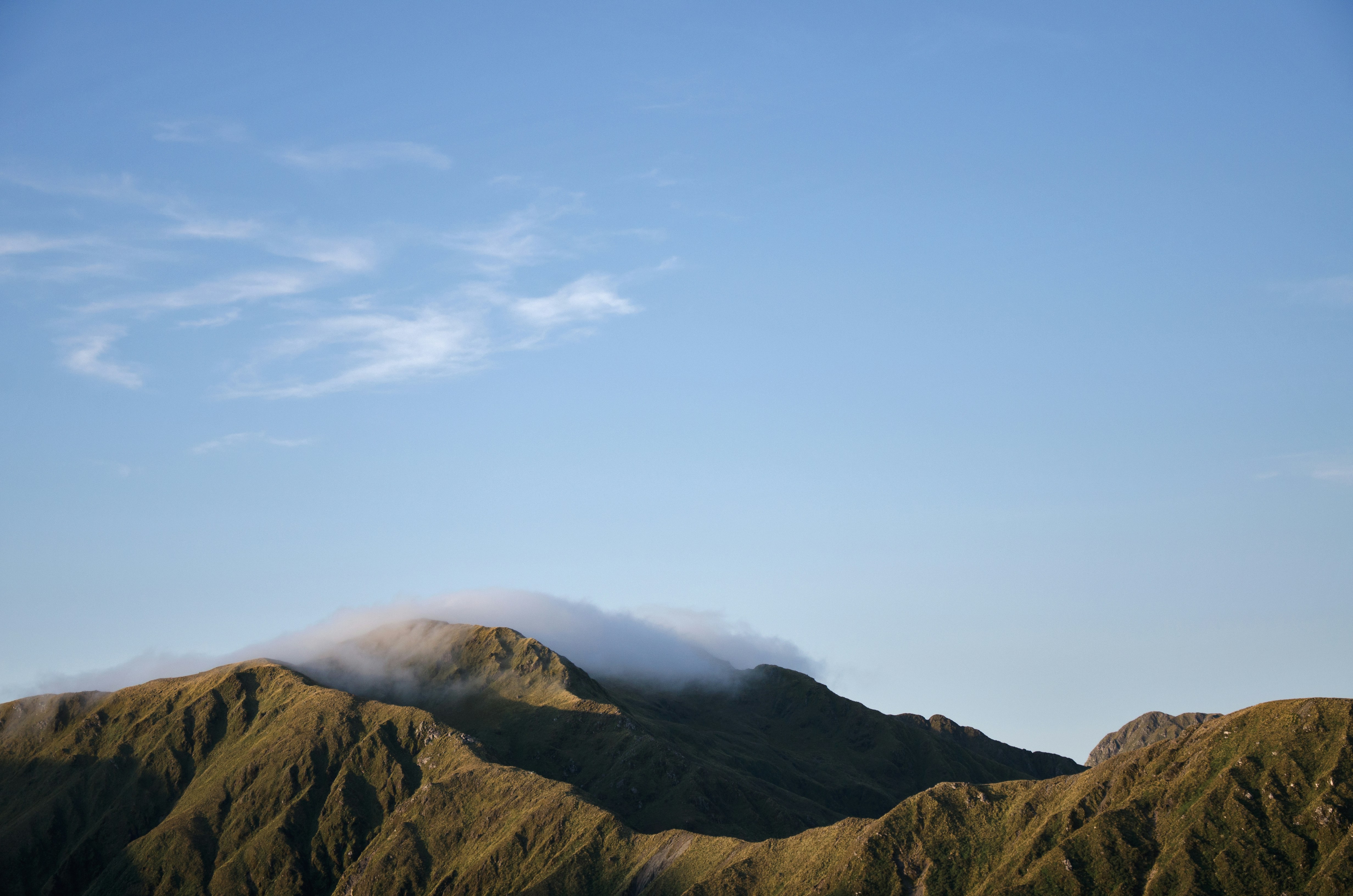
The GR21, also known as the "Sentier de la Côte d'Albâtre" (Alabaster Coast Path), is one of France's most visually arresting long-distance hiking routes. Stretching approximately 190 kilometres along the coastline of the Seine-Maritime department in Normandy, this trail offers a dramatic journey atop towering white chalk cliffs that plunge vertically into the turquoise and emerald waters of the English Channel. Starting from the port city of Le Havre—a UNESCO World Heritage site renowned for its modernist architecture—and concluding in the historic seaside resort of Le Tréport, the GR21 weaves through a landscape defined by "valleuses" (hanging valleys), pebble beaches, and iconic coastal towns that inspired the birth of Impressionism. In 2020, it was officially voted France's favourite long-distance trail (Mon GR préféré), a testament to its unique blend of raw maritime power, pastoral French charm, and accessible yet challenging terrain.
The GR21 is a masterclass in coastal geology and atmospheric light. The trail follows the "Pays de Caux" plateau, a vast limestone tableland that ends abruptly in the famous Alabaster Cliffs. These cliffs, reaching heights of over 100 metres, are composed of white chalk interspersed with horizontal bands of black flint. The constant erosion by wind and sea creates a dynamic landscape where the path itself must occasionally be moved inland to account for the "recul du trait de côte" (coastal retreat). For the hiker, this means a journey of constant contrast: one moment you are walking through high-altitude maritime meadows with sweeping views of the horizon, and the next you are descending a steep "valleuse" to reach a secluded pebble beach or a bustling fishing harbour.
The terrain is deceptively demanding. While the maximum elevation never exceeds 130 metres above sea level, the cumulative gain of 6,000 metres tells the true story of the trail. The plateau is dissected by dozens of small valleys. Every few kilometres, the trail drops to sea level only to climb immediately back to the cliff tops. This "sawtooth" profile tests the endurance of even seasoned walkers, particularly when carrying a full multi-day pack. However, the rewards are immense. The trail passes through legendary locations such as Étretat, with its natural arches and "needle" rock formations, and Fécamp, a town steeped in the history of cod fishing and Benedictine monks.
Culturally, the GR21 is a walk through the history of French leisure and art. In the 19th century, these shores became the playground of the Parisian elite, leading to the construction of ornate "Belle Époque" villas that still line the seafronts of towns like Veules-les-Roses and Mers-les-Bains. The unique quality of the light here—often a soft, pearlescent grey or a brilliant, sharp blue—captured the imagination of painters like Claude Monet and Eugène Boudin. Walking the GR21 is, in many ways, walking through a living gallery of Impressionist masterpieces. Whether you are watching the sunset over the Porte d'Aval in Étretat or navigating the narrow streets of Dieppe, the connection between the landscape and the art it inspired is palpable and profound.
The origins of the GR21 are rooted in the "Sentier des Douaniers" (Customs Officers' Path). Created during the French Revolution and expanded under Napoleon, these coastal paths were designed to allow customs officers to patrol the shoreline on foot, day and night, to combat smuggling and monitor potential maritime invasions. The officers needed a clear view of every cove and "valleuse" where contraband might be landed. Today's hikers follow in the footsteps of these patrols, benefiting from the strategic vantage points they established centuries ago. The path fell into disuse with the advent of modern surveillance technology but was revitalised in the 20th century as part of France's extensive "Grande Randonnée" (GR) network, managed by the Fédération Française de la Randonnée Pédestre (FFRandonnée).
The region's history is also deeply tied to the sea. For centuries, towns like Fécamp and Dieppe were the epicentres of the French fishing industry. Fécamp, in particular, was the home port for the "Terre-Neuvas"—fishermen who undertook perilous months-long voyages to the Grand Banks of Newfoundland to hunt for cod. This maritime heritage is visible in the sturdy architecture of the harbours, the votive offerings in coastal chapels, and the local gastronomy. Furthermore, the GR21 traverses ground that saw significant action during World War II. The Alabaster Coast was a key component of Hitler's "Atlantic Wall," and hikers will frequently encounter the remains of concrete bunkers and gun emplacements built by the occupying German forces. The tragic Dieppe Raid of 1942 (Operation Jubilee) is commemorated throughout the town of Dieppe, serving as a somber reminder of the coast's strategic importance.
Beyond conflict and commerce, the GR21 is a celebration of the "Pays de Caux" rural identity. Inland from the cliffs, the trail passes through traditional Norman farmsteads known as "clos-masures." These are unique agricultural ensembles where farm buildings and orchards are surrounded by a rectangular earthen bank planted with tall beech trees to protect the crops and livestock from the fierce maritime winds. This traditional land management system has shaped the Norman countryside for over a thousand years and provides a tranquil, pastoral counterpoint to the dramatic coastal scenery.
Want more background? Read extended notes on history and cultural context → Learn more
The GR21 is best experienced from late spring to early autumn, though the maritime climate of Normandy ensures that weather is always a factor. Unlike the Mediterranean south, Normandy is characterised by its variability; it is not uncommon to experience "four seasons in one day."
Spring (May to June): This is arguably the most beautiful time to hike. The clifftop meadows are carpeted in wildflowers, and the inland sections through the Pays de Caux are vibrant green. Temperatures are mild (12–18°C), making for comfortable walking. However, spring can also bring the "crachin normand"—a fine, persistent drizzle that can last for hours. Visibility can be limited by sea mists, which add a mystical quality to the cliffs but require careful navigation.
Summer (July to August): This is the peak tourist season. The weather is generally at its most stable, with temperatures ranging from 20°C to 25°C, though heatwaves can occasionally push it higher. The sea is at its warmest for those brave enough to swim from the pebble beaches. The downside is the crowd, particularly in hotspots like Étretat and Veules-les-Roses. Accommodation must be booked well in advance during these months.
Autumn (September to October): September is a "golden month" on the GR21. The summer crowds have dispersed, the sea remains relatively warm, and the light takes on a crisp, clear quality. The autumn colours in the beech forests and orchards are spectacular. By October, the risk of Atlantic storms increases, and the wind on the cliff tops can become punishingly strong.
Winter (November to April): While the trail remains open, winter hiking on the GR21 is for the hardy. Frequent gales, heavy rain, and short daylight hours make it a challenging prospect. Many seasonal gîtes and campsites close during this period. However, for those seeking solitude and the raw power of a winter sea battering the chalk cliffs, it can be a deeply atmospheric experience. Proper waterproof and windproof gear is non-negotiable.
Day 1: Le Havre to Octeville-sur-Mer
Day 2: Octeville-sur-Mer to Étretat
Day 3: Étretat to Fécamp
Day 4: Fécamp to Saint-Pierre-en-Port
Day 5: Saint-Pierre-en-Port to Saint-Valery-en-Caux
Day 6: Saint-Valery-en-Caux to Veules-les-Roses
Day 7: Veules-les-Roses to Saint-Aubin-sur-Mer
Day 8: Saint-Aubin-sur-Mer to Dieppe
Day 9: Dieppe to Le Tréport
Important Notes:
The GR21 requires a moderate level of fitness. While the paths are generally well-maintained, the constant "up and down" nature of the trail can be taxing on the knees and calves. Training on hilly terrain with a weighted pack is highly recommended. Logistics are relatively straightforward: Le Havre is easily accessible by train from Paris (Gare Saint-Lazare), taking approximately 2 hours. At the northern end, Le Tréport also has a railway station with connections back to Paris or towards Amiens.
Language is a consideration; while staff in major tourist hubs like Étretat or Dieppe will speak English, a basic grasp of French is invaluable for booking gîtes, ordering in local boulangeries, and interacting with residents in smaller villages. It is also essential to carry a physical map (IGN Top 25 series) or a reliable offline GPS app, as cliff erosion occasionally forces local diversions that may not be perfectly marked.
The GR21 offers a diverse range of accommodation, from budget-friendly campsites to luxury hotels. Because the trail passes through many towns, you are rarely far from a bed.
Types of Accommodation:
Booking Requirements:
One of the great advantages of hiking in France is the "liberté de circulation" on public footpaths. No permits are required to walk the GR21, and there are no trail fees. The path is maintained by volunteers from the FFRandonnée and local authorities.
Access and Regulations:
Transport Logistics:


Precisely traced GPX for the Gr21, ready for your GPS or favourite mapping app.
Normandy is a region rich in culture and gastronomy. Consider adding these experiences to your trip:
Cliff Erosion and Rockfalls: This is the primary safety concern on the GR21. The chalk cliffs are extremely unstable. Never walk near the edge of the cliffs, even for a photograph; sections can collapse without warning. Similarly, if you descend to the beach, avoid sitting or walking directly at the base of the cliffs. Rockfalls are frequent and can be fatal. Always follow the official GR21 markings, as they are regularly moved inland to bypass dangerous sections.
Tides: While the GR21 mostly stays on top of the cliffs, some hikers choose to walk sections on the beach. This is only possible at low tide. The tide comes in very quickly against the vertical cliffs, and there are many sections with no escape routes. If you plan to walk on the pebbles, you MUST consult a tide table (horaire des marées) and ensure you have a wide window of safety. Sea mists can also roll in rapidly, disorienting walkers on the beach.
Weather Extremes: The cliff tops are completely exposed. In high winds, walking can be dangerous, especially near the edge. In summer, the white chalk reflects heat and UV rays intensely; heatstroke and severe sunburn are genuine risks. Always carry adequate water, as there is no shade on the plateau sections.
Hunting Season: In France, hunting season typically runs from September to February. While the GR21 is a popular trail, it passes through rural areas where hunting occurs. Wear bright colours (high-visibility vests are a good idea) if hiking during this period, especially on Thursdays and weekends.
Emergency Contacts:
Varengeville-sur-Mer: Located just west of Dieppe, this village is often cited as one of the most beautiful in France. The church of Saint-Valery sits precariously on the cliff edge, and its cemetery contains the grave of painter Georges Braque, featuring a stunning stained-glass window he designed. The nearby "Parc du Bois des Moutiers" is a magnificent garden designed by Gertrude Jekyll.
Cap Fagnet: Located just north of Fécamp, this is the highest point on the Alabaster Coast. It offers a 360-degree view of the sea and the town. It is also home to a well-preserved radar station and bunkers from the Atlantic Wall, providing a stark historical perspective on the landscape.
Mers-les-Bains: Technically just across the river from Le Tréport, this town is famous for its "Quartier Balnéaire." It features rows of incredibly colourful, ornate seaside villas from the late 19th century, each with intricate wooden balconies and ceramic decorations. It is one of the best-preserved examples of Belle Époque seaside architecture in Europe.
The Valleuse of Senneville: For those wanting to see the geology up close, the descent into the Valleuse de Senneville (near Fécamp) is spectacular. It shows the perfect "V" shape of these dry valleys and provides access to a very quiet, wild section of the coast away from the main tourist hubs.
The Alabaster Coast is a fragile environment under constant pressure from erosion and tourism. As a hiker, your impact can be significant. The chalk grasslands on the cliff tops are home to rare orchids and nesting seabirds like fulmars and peregrine falcons.
Guidelines for the GR21: