GR20 - Southern Half: Corsica's Mountain Traverse
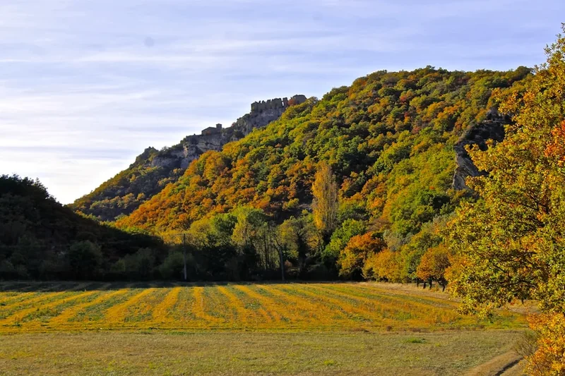
The GR20, often cited as one of Europe's most challenging long-distance hiking trails, traverses the rugged spine of Corsica, France. This description focuses on the southern half of the GR20, a demanding 90 km section that winds through dramatic granite peaks, deep glacial valleys, and ancient forests. Starting from Vizzavona, the southern half presents a relentless series of ascents and descents, testing the endurance and technical skill of even experienced hikers. It is a journey through a wild, untamed landscape, where the raw beauty of the Mediterranean's most mountainous island is on full display. This section is renowned for its steep, rocky terrain, exposed ridges, and the sheer scale of its alpine environment, offering a profound sense of accomplishment upon completion.
- Distance: 90.0 km (Southern Half)
- Duration: 7–9 days
- Season: June to September (weather dependent)
- Difficulty: Very Challenging
- Highest point: Monte Incudine (2,147 m)
- Accommodation: Refuges, bivouac shelters, and designated camping areas
- Start: Vizzavona
- End: Conca
Overview
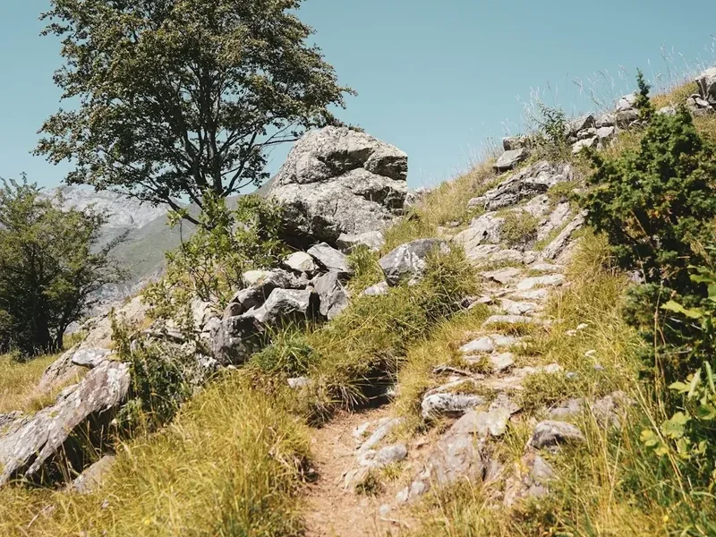
The southern half of the GR20 is a true test of mountain fortitude. Unlike its northern counterpart, which is often considered more technically demanding with its scrambling and via ferrata sections, the southern GR20 is characterised by its relentless elevation changes and the sheer physical exertion required. Hikers will encounter steep, scree-covered slopes, narrow goat tracks clinging to cliff faces, and long, arduous ascents to high mountain passes. The landscape is a breathtaking panorama of Corsican wilderness: jagged granite peaks pierce the sky, deep valleys carved by ancient glaciers plunge below, and fragrant maquis shrubland blankets the lower slopes. The air is often filled with the scent of wild herbs, and the only sounds are the wind, the bleating of sheep, and the distant calls of birds of prey.
This section of the GR20 is not for the faint-hearted. It demands a high level of fitness, excellent navigation skills, and a robust mental attitude. The days are long, often starting before dawn to make the most of cooler temperatures and to avoid the midday sun, which can be intense even at higher altitudes. The terrain underfoot is consistently rough, requiring careful foot placement and sturdy hiking boots. While there are fewer technical climbing sections compared to the north, the sheer exposure on some ridges and the steepness of the descents can be intimidating. However, for those who persevere, the rewards are immense: unparalleled views, a profound connection with nature, and the deep satisfaction of conquering one of Europe's most iconic trails.
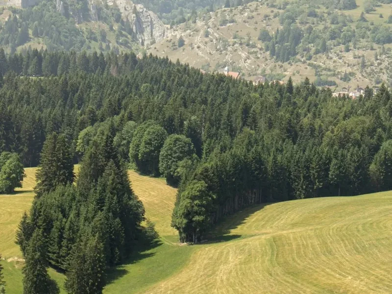
The trail passes through a variety of microclimates and ecosystems. Lower down, the maquis, a dense, aromatic scrubland, dominates, giving way to pine forests as elevation increases. Higher up, the landscape becomes more alpine, with rocky outcrops, sparse vegetation, and the occasional snow patch lingering into early summer. The refuges and bivouac sites offer essential respite, providing basic accommodation and a chance to share experiences with fellow hikers from around the globe. The camaraderie forged on the GR20 is a significant part of its appeal, with hikers supporting each other through the challenges and celebrating successes together.
History and Cultural Context
Corsica, known as the "Mountain in the Sea," has a long and rich history of human habitation, with its rugged terrain shaping its culture and way of life. For centuries, the island's inhabitants have navigated its challenging interior, using ancient tracks and paths to connect villages, herd livestock, and trade goods. The GR20, while a relatively modern concept as a marked long-distance trail, follows in the footsteps of these historical routes, many of which were originally used by shepherds and hunters.
The GR20 trail itself was conceived in the 1970s by the French Alpine Club (Club Alpin Français - CAF) and the Corsican Regional Natural Park (Parc Naturel Régional de Corse - PNRC). The aim was to create a marked route that would showcase the island's spectacular mountain scenery and promote hiking tourism. The trail was officially opened in 1972, though it has undergone numerous modifications and improvements over the years to enhance safety and accessibility, while still retaining its wild character. The trail's development was a significant undertaking, involving the marking of routes, the construction of refuges, and the establishment of camping areas.
The southern half of the GR20, in particular, traverses areas that have historically been used for transhumance – the seasonal movement of livestock between different grazing areas. You will still see shepherds tending their flocks in some of the higher pastures, a testament to the enduring connection between the Corsican people and their mountainous environment. The trail also passes near ancient shepherd's huts and stone shelters, remnants of a bygone era. The cultural significance of the GR20 extends beyond its hiking appeal; it is a vital part of Corsica's identity, offering a unique way to experience the island's natural beauty and its deep-rooted traditions.
Seasonal Highlights and Weather Reality
The GR20 is a seasonal trail, with the prime hiking window typically running from June to September. Outside these months, conditions can be significantly more challenging and dangerous.
June: The start of the season. Snow can still linger at higher elevations, particularly on north-facing slopes and in shaded gullies. Water sources are generally abundant. The maquis is in bloom, offering a fragrant and colourful experience. Days are long, providing ample daylight for hiking. However, early June can still see unpredictable weather, including late snowfalls or storms.
July and August: Peak season. The weather is generally hot and dry, with long, sunny days. This is the most popular time to hike the GR20, meaning refuges and campsites can be crowded. Water sources may become scarcer in some areas, requiring careful planning. The heat can be intense, especially during the midday sun, making early starts and late finishes essential. Thunderstorms are common in the afternoons, often developing rapidly and bringing heavy rain, lightning, and strong winds.
September: The weather often begins to cool, and the crowds start to thin. The autumn colours begin to appear in the forests, offering a different kind of beauty. The risk of thunderstorms may decrease, but unpredictable weather can still occur. Water sources are usually reliable. September is often considered an ideal month for hiking the GR20, offering a good balance of favourable weather and fewer people.
October and beyond: The season officially closes at the end of September, and refuges begin to shut down. Snowfall becomes increasingly likely from October onwards, making the trail impassable without winter mountaineering equipment and expertise. Attempting the GR20 outside the official season is strongly discouraged and extremely dangerous.
Weather Considerations: Corsican mountain weather is notoriously unpredictable. Even in summer, conditions can change rapidly. Hikers must be prepared for all eventualities, including strong winds, heavy rain, fog, and sudden temperature drops, especially at higher altitudes. Hypothermia is a risk even in summer if caught out in severe weather.
Recommended Itinerary
7-Day GR20 Southern Half Itinerary (Vizzavona to Conca)
Day 1: Vizzavona to Refuge de Prati
- Distance: 14.0 km
- Elevation gain: 1,200 m
- Elevation loss: 600 m
- Time: 6–8 hours
- Start at Vizzavona train station
- Ascend through dense forests of beech and pine
- Pass the Cascade de Vizzavona
- Climb towards the Bocca di Vizzavona
- Continue ascent towards the plateau of Prati
- Arrive at Refuge de Prati (1,820 m)
- Camping available near the refuge
Day 2: Refuge de Prati to Refuge d'Usciolu
- Distance: 10.0 km
- Elevation gain: 700 m
- Elevation loss: 500 m
- Time: 5–7 hours
- Traverse high mountain pastures and rocky terrain
- Pass the imposing Monte Incudine (2,147 m) – optional detour for summit views
- Enjoy panoramic views of the southern Corsican mountains
- Descend towards the Refuge d'Usciolu (1,750 m)
- Camping available near the refuge
Day 3: Refuge d'Usciolu to Refuge de Manganu
- Distance: 12.0 km
- Elevation gain: 600 m
- Elevation loss: 800 m
- Time: 5–7 hours
- Steep descent from Usciolu
- Cross the Bocca di Verde
- Enter a more forested landscape
- Arrive at Refuge de Manganu (1,500 m)
- Camping available near the refuge
Day 4: Refuge de Manganu to Refuge de Petra Piana
- Distance: 10.0 km
- Elevation gain: 900 m
- Elevation loss: 500 m
- Time: 5–7 hours
- Challenging ascent towards the high ridges
- Pass through rocky, exposed sections
- Spectacular views of the surrounding peaks
- Arrive at Refuge de Petra Piana (1,840 m)
- Camping available near the refuge
Day 5: Refuge de Petra Piana to Refuge de l'Onda
- Distance: 10.0 km
- Elevation gain: 500 m
- Elevation loss: 900 m
- Time: 5–6 hours
- Descend from Petra Piana
- Pass through varied terrain, including forests and rocky outcrops
- Arrive at Refuge de l'Onda (1,430 m)
- Camping available near the refuge
Day 6: Refuge de l'Onda to Refuge de Bavella
- Distance: 15.0 km
- Elevation gain: 800 m
- Elevation loss: 700 m
- Time: 6–8 hours
- A long and demanding day
- Ascend towards the dramatic Bavella massif
- Pass through the iconic Aiguilles de Bavella (Bavella Needles)
- Arrive at Refuge de Bavella (1,218 m)
- Camping available near the refuge
Day 7: Refuge de Bavella to Conca
- Distance: 10.0 km
- Elevation gain: 300 m
- Elevation loss: 800 m
- Time: 3–4 hours
- Final descent towards the coast
- Pass through maquis shrubland
- Arrive in the village of Conca, marking the end of the southern GR20
- Celebratory meal and transport options from Conca
Important Notes:
- This itinerary is a suggestion and can be adapted based on fitness levels and weather conditions.
- Refuges offer basic accommodation (dormitories) and often have a small shop selling snacks and drinks. Booking in advance is highly recommended, especially during peak season.
- Camping is permitted only in designated areas near refuges.
- Water sources can be unreliable, especially in late summer. Always carry sufficient water and a purification method.
- The terrain is consistently rough and rocky; sturdy hiking boots are essential.
- Be prepared for rapid weather changes.
Planning and Bookings
Book Your Trip
Everything you need to plan your journey
Accommodation
Find places to stay near Porto-Vecchio
Flights
Search flights to Porto-Vecchio
Essential Preparation
The GR20 is a serious undertaking that requires meticulous planning. Begin your preparations months in advance, especially if you intend to hike during the peak season (July-August). Key logistical considerations include booking accommodation, arranging transport to and from the trailheads, and ensuring you have the correct gear. Corsica's mountainous terrain means that travel between trail points can be time-consuming. The nearest major airport is Ajaccio (AJA) or Bastia (BIA). From these airports, you can take buses or hire cars to reach Vizzavona (start of the southern half) and Conca (end of the southern half). Public transport can be infrequent, so consider pre-booking transfers or car hire. For those starting from Vizzavona, the train station is a convenient access point. For the end point in Conca, onward transport to Ajaccio or Bastia will be necessary.
Trail Accommodation
Accommodation on the GR20 southern half consists of refuges, bivouac shelters, and designated camping areas. Refuges are managed by the Parc Naturel Régional de Corse and offer basic dormitory-style sleeping arrangements. They typically have a common area, and some offer meals (breakfast and dinner) for an additional cost. Booking refuges in advance is strongly advised, particularly during July and August, as they have limited capacity and are often fully booked. Bivouac shelters are more rudimentary, often just a stone structure offering basic protection from the elements. Designated camping areas are usually located near the refuges, allowing hikers to pitch their own tents. These sites often have access to water and toilet facilities.
Refuge Facilities:
- Bunk beds with mattresses (sleeping bags required)
- Common dining area
- Toilets (often basic pit toilets)
- Access to water (stream water, treatment recommended)
- Some refuges offer hot showers (may be limited or require payment)
- Some refuges have a small shop selling basic provisions, drinks, and sometimes camping gas.
What Refuges Don't Provide:
- Pillows or bedding (bring your own sleeping bag liner or lightweight sleeping bag)
- Cooking equipment (pots, pans, utensils) – unless you plan to self-cater and cook outside
- Food (unless you pre-book meals)
- Electricity for charging devices (some refuges may have limited charging points, but do not rely on them)
- WiFi or mobile signal (very limited and unreliable)
Booking Requirements:
- Bookings for refuges can be made via the PNRC website or by contacting individual refuges directly.
- Peak season (July-August) requires booking months in advance.
- Costs vary but expect approximately €15-€25 per night for a dormitory bed and €5-€10 for a camping spot. Meals are extra.
Required Gear
- Sturdy Hiking Boots: Waterproof, broken-in boots with good ankle support are essential due to the rocky and uneven terrain.
- Backpack: A 45-65 litre backpack with a good hip belt and rain cover.
- Waterproof Jacket and Trousers: Essential for protection against rain and wind, which can change rapidly.
- Warm Layers: Fleece jacket, thermal base layers, and a warm hat and gloves. Temperatures can drop significantly at night and at higher altitudes.
- Sleeping Bag: A 3-season sleeping bag (rated to around 0°C comfort) is recommended, as refuges are unheated. A sleeping bag liner can add warmth and keep your sleeping bag cleaner.
- Head Torch: With spare batteries, for navigating in refuges and during early morning or late evening hikes.
- First-Aid Kit: Comprehensive kit including blister treatment, pain relievers, antiseptic wipes, bandages, and any personal medications.
- Navigation Tools: Detailed maps of the GR20, a compass, and a GPS device or smartphone with offline maps. While the trail is generally well-marked, navigation can be challenging in poor visibility.
- Sun Protection: High SPF sunscreen, sunglasses, and a wide-brimmed hat.
- Trekking Poles: Highly recommended for stability on descents and ascents, and to reduce strain on knees.
What to Bring
- Food: Carry enough high-energy, lightweight food for the days between refuges. This includes breakfast, lunch, snacks, and dinner if you are not pre-booking meals. Dried meals, nuts, dried fruit, energy bars, and jerky are good options.
- Water Bottles/Bladder: Carry at least 2-3 litres of water capacity per person.
- Water Purification: A water filter, purification tablets, or a UV steriliser is essential, as water sources can be contaminated.
- Toiletries: Biodegradable soap, toothbrush, toothpaste, toilet paper, hand sanitiser, and any personal hygiene items.
- Quick-dry Towel: Lightweight and fast-drying.
- Repair Kit: Duct tape, safety pins, needle and thread for gear repairs.
- Cash: Euros are essential, as credit card facilities are rare, especially in smaller refuges and villages.
- Mobile Phone: For emergencies, though signal is very limited. Consider a power bank to keep it charged.
- Personal Locator Beacon (PLB) or Satellite Messenger: Highly recommended for emergency communication in remote areas.
- Insect Repellent: Especially for mosquitoes and biting flies, though less of an issue than sandflies in New Zealand.
Permits
Unlike some other major European long-distance trails, the GR20 does not require a formal permit to hike. However, access to the trail and its facilities is managed through booking systems for accommodation and camping. The Parc Naturel Régional de Corse (PNRC) oversees the management of the refuges and camping areas along the trail.
Accommodation Bookings:
- Refuges: It is highly recommended to book your stay in the refuges in advance, especially if you plan to hike during the peak season (July and August). Bookings can typically be made online through the PNRC website or by contacting individual refuges directly. Failure to book can result in being turned away, especially during busy periods.
- Camping: Designated camping areas are usually located near the refuges. While often less strictly controlled than refuge bookings, it is still advisable to check with the refuge guardian upon arrival to confirm availability and any associated fees.
Fees:
- There is no fee to simply walk the GR20.
- Fees apply for staying in refuges or camping in designated areas. These fees vary but are generally reasonable for the services provided. Expect to pay approximately €15-€25 per night for a dormitory bed in a refuge and €5-€10 for a camping spot.
- Meals at refuges are an additional cost, typically around €15-€20 for dinner and €8-€10 for breakfast.
Seasonality: The GR20 is a seasonal trail. The official season for the refuges and services typically runs from early June to late September. Outside of this period, refuges may be closed, and services will be unavailable, making the trail significantly more challenging and potentially dangerous due to snow and ice.
Important Note: While no specific permit is required to walk the trail, respecting the rules and regulations set by the PNRC regarding accommodation and camping is crucial for the preservation of the environment and the enjoyment of all hikers.
Other Activities in the Area
Beyond the GR20 itself, Corsica offers a wealth of activities for those looking to extend their stay or explore the island further:
- Coastal Hiking: Corsica boasts stunning coastal paths, such as the Sentier des Douaniers (Customs Officers' Trail) in the Scandola Nature Reserve or the trails around the Cap Corse peninsula, offering dramatic sea views and beautiful beaches.
- Beach Relaxation: The southern coast, particularly around Porto-Vecchio and Bonifacio, features some of the most beautiful beaches in the Mediterranean, with crystal-clear turquoise waters and white sandy shores.
- Water Sports: Activities like swimming, snorkelling, diving, kayaking, and paddleboarding are popular along the coast. Boat trips to explore hidden coves and sea caves are also readily available.
- Cultural Exploration: Visit historic towns like Ajaccio (birthplace of Napoleon Bonaparte), Bastia with its charming old port, and the fortified town of Bonifacio perched dramatically on limestone cliffs. Explore ancient stone villages in the interior.
- Gastronomy: Corsican cuisine is a delight, featuring local specialities such as charcuterie (including coppa, lonzu, and figatellu), cheeses (like brocciu), wild boar dishes, and delicious pastries and cakes. Enjoy local wines and the famous Corsican liqueur, Cap Corse.
- Canyoning and Via Ferrata: For adrenaline seekers, Corsica offers excellent opportunities for canyoning in its mountain rivers and via ferrata routes, particularly in the Bavella region.
- Scuba Diving: The clear waters around Corsica are ideal for diving, with numerous dive sites offering a chance to see diverse marine life and underwater landscapes.
Safety and Conditions
Pre-Trip Checks:
- Weather Forecast: Always check the latest mountain weather forecast for Corsica before and during your hike. Conditions can change rapidly, with thunderstorms being a common occurrence, especially in the afternoons during summer. Websites like Météo-France Corse provide detailed forecasts.
- Trail Conditions: While the GR20 is generally well-marked, sections can be affected by snow (early season), rockfalls, or landslides. Check with local authorities or refuge guardians for any specific alerts or closures.
- Water Sources: In late summer, some water sources may dry up. Plan your water refills carefully and always carry a water purification method (filter, tablets, or UV steriliser).
On-Trail Safety:
- Navigation: While the trail is marked with red and white paint flashes and cairns, it is essential to carry a map and compass and know how to use them. Visibility can drop dramatically in fog or storms, making navigation difficult.
- Physical Fitness: The GR20 is a very demanding trail. Ensure you are adequately fit and have trained for long days of hiking over steep, rocky terrain.
- Hypothermia: Even in summer, temperatures at higher altitudes can drop significantly, and sudden storms can lead to hypothermia. Carry warm, waterproof layers and know the signs and treatment of hypothermia.
- Falls and Injuries: The terrain is often rough and exposed. Take your time, wear appropriate footwear, and use trekking poles for stability. Be aware of loose rocks and scree.
- Heatstroke: During July and August, the midday sun can be intense. Start your hikes early, take breaks in the shade, and stay well-hydrated.
- Emergency Contacts: Know the emergency numbers for France (112). Consider carrying a Personal Locator Beacon (PLB) or satellite messenger for reliable communication in areas with no mobile signal.
- Respect Wildlife: While large predators are absent, be aware of snakes (though generally not aggressive) and respect the local fauna.
Refuge Etiquette: Follow the rules and guidelines set by the refuge guardians. This includes respecting quiet hours, keeping communal areas clean, and conserving water and resources.
Side Trips and Points of Interest
Monte Incudine: The highest peak in the southern GR20, reaching 2,147 metres. A challenging but rewarding detour from the main trail between Refuge de Prati and Refuge d'Usciolu. The summit offers spectacular 360-degree views across the rugged Corsican landscape, stretching as far as the coast on a clear day.
Aiguilles de Bavella: The dramatic granite spires of the Bavella massif are a highlight of the southern GR20. The trail passes through this stunning landscape, offering incredible photographic opportunities. Several short, steep hikes lead to viewpoints offering even more dramatic perspectives of these iconic rock formations.
Cascade de Vizzavona: Located near the start of the southern GR20 in Vizzavona, this beautiful waterfall is a refreshing stop and a picturesque introduction to the natural beauty of Corsica's interior.
Lac de Melo and Lac de Capitello: While slightly off the main GR20 route and requiring a significant detour (often from the northern section or as a separate day trip from Corte), these two stunning glacial lakes are among Corsica's most beautiful natural attractions. They are accessible via challenging hiking trails and offer breathtaking alpine scenery.
Shepherd's Huts (Caseddi): Throughout the southern GR20, you will encounter ancient stone shepherd's huts, known as "caseddi." These offer a glimpse into the traditional way of life in the Corsican mountains and are often used as emergency shelters.
Leave No Trace
The GR20 traverses a pristine and fragile mountain environment. Adhering to Leave No Trace principles is paramount to preserving its beauty and ecological integrity for future generations. The Corsican mountains are a vital habitat for unique flora and fauna, and the trail's popularity means that responsible behaviour is essential.
Your responsibility as a hiker:
- Pack It In, Pack It Out: Carry out all litter, including food scraps, wrappers, and any other waste. Do not bury or burn trash.
- Stay on the Trail: Stick to the marked path to avoid damaging fragile vegetation, preventing erosion, and protecting sensitive habitats. The Corsican maquis and alpine meadows are easily damaged.
- Dispose of Waste Properly: Use designated toilets at refuges and campsites. If no facilities are available, dig a cathole at least 60 metres away from water sources, trails, and campsites. Pack out all toilet paper.
- Leave What You Find: Do not take rocks, plants, or any other natural objects. Leave them for others to enjoy and for the ecosystem to thrive.
- Minimise Campfire Impacts: Campfires are generally prohibited on the GR20 due to fire risk and environmental impact. Use a lightweight stove for cooking. If a fire is absolutely necessary and permitted, use existing fire rings and ensure it is completely extinguished.
- Respect Wildlife: Observe wildlife from a distance and never feed animals. Feeding can alter their natural behaviour and diet, leading to health problems.
- Be Considerate of Other Visitors: Keep noise levels down, especially in refuges and camping areas. Yield to uphill hikers.
By following these principles, you contribute to the conservation of Corsica's magnificent mountain wilderness.