France — Corte
Corsica's GR20, a 180km traverse across its granite spine, is Europe's most demanding long-distance walk. This 15-day route, known locally as "Fra li Monti," plunges through rugged highlands and across exposed ridges, offering immense natural beauty and profound physical exertion. Expect steep ascents, technical scrambles, and breathtaking panoramas on this legendary French trail.
Distance: 180.0 km
Elevation Gain: 12000 m
Difficulty: Very Challenging
Duration: 15 days
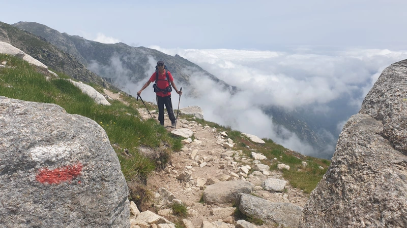
The GR20 is widely regarded as the most difficult and spectacular long-distance trail in Europe. Stretching approximately 180 kilometres along the jagged granite spine of Corsica, this legendary route—known in the local Corsican language as the "Fra li Monti" (Across the Mountains)—is a journey of immense physical demand and profound natural beauty. It bisects the Mediterranean island from Calenzana in the northwest to Conca in the southeast, traversing a landscape that feels more like the high Alps than a coastal island. With over 12,000 metres of cumulative elevation gain, the trail is a relentless sequence of steep ascents, technical rock scrambles, and knee-shattering descents through some of the most rugged terrain on the continent. This is not a walk for the casual hiker; it is a high-altitude endurance test that rewards the prepared with views of turquoise glacial lakes, ancient pine forests, and the shimmering Mediterranean Sea visible from 2,000-metre ridges.
The GR20 is a trail of two distinct halves, separated by the mountain village of Vizzavona. The Northern section (Stages 1–9) is the stuff of hiking legend: a brutal, technical, and breathtakingly beautiful stretch of trail where the path often disappears into fields of granite boulders and steep slabs. Here, hikers must frequently use their hands for balance as they navigate narrow ridges and steep couloirs. The terrain is dominated by crystalline rock, glacial cirques, and the iconic Laricio pines that cling to the wind-swept slopes. This section includes the ascent toward Monte Cinto, the highest peak in Corsica, and the crossing of the high plateaus where snow can linger well into June.
The Southern section (Stages 10–15), while slightly lower in average elevation and less technically demanding, is by no means "easy." It offers a different kind of beauty, characterized by lush forests, rolling alpine meadows (pozzines), and the dramatic limestone-like needles of the Aiguilles de Bavella. The heat becomes a more significant factor in the south as the trail descends toward the Mediterranean scrubland known as the maquis. Throughout the entire journey, the scent of this maquis—a fragrant blend of rosemary, wild mint, lavender, and myrtle—follows the hiker, a sensory reminder that despite the alpine surroundings, you are in the heart of the Mediterranean.
Logistically, the GR20 is managed by the Parc Naturel Régional de Corse (PNRC). To protect the fragile island ecosystem, wild camping is strictly prohibited. Hikers must stay at the official refuges or in designated camping areas immediately adjacent to them. This creates a unique social atmosphere; every evening, a diverse international community of trekkers gathers to share stories, local Corsican cheese, and the occasional glass of Pietra (the local chestnut beer) before collapsing into bunks or tents. The GR20 is more than just a hike; it is a rite of passage for mountain lovers, a test of mental fortitude, and a deep immersion into the wild, uncompromising heart of Corsica.
The GR20 was not "discovered" so much as it was synthesised from centuries of Corsican mountain tradition. For generations, the paths that now form the trail were used by shepherds for transhumance—the seasonal movement of livestock between lowland winter pastures and high-altitude summer grazing lands. These "bergeries" (shepherd huts) still dot the landscape, and many continue to produce the famous Corsican brocciu cheese using traditional methods. The mountains were also a place of refuge and resistance throughout Corsica's turbulent history, providing a stronghold for those opposing various waves of Mediterranean invaders.
The modern concept of the GR20 as a continuous long-distance trek was the brainchild of Michel Fabrikant, a French mountaineer and writer. In the late 1960s, Fabrikant explored the island's interior, mapping out a route that would link the existing shepherd paths into a single, cohesive traverse of the mountain spine. His vision was realised in 1972 with the official inauguration of the trail. Since then, it has grown from an obscure challenge for elite climbers into a world-renowned trekking destination. Despite its popularity, the trail has resisted over-development; the refuges remain basic, the terrain remains raw, and the sense of isolation in the high mountains is as potent today as it was fifty years ago.
Walking the GR20 is also an encounter with the unique Corsican identity. The island has a distinct language, culture, and history that is fiercely protected by its inhabitants. Hikers will notice the bilingual signs (French and Corsican) and the Moor's Head symbol—the national emblem of Corsica—displayed proudly throughout the villages. Respecting the local environment and traditions is paramount; the mountains are the ancestral home of the Corsican people, and the trail is a privilege to walk.
Want more background? Read extended notes on history and cultural context → Learn more
The window for successfully completing the GR20 is relatively narrow, dictated by the presence of snow in the spring and the onset of autumn storms. The official season for the refuges typically runs from late May or early June through to the end of September. Outside of this window, the trail becomes a serious mountaineering undertaking requiring ice axes, crampons, and advanced winter navigation skills.
June: This is arguably the most beautiful month to hike. The days are long, the wildflowers are in full bloom, and the mountain streams are rushing with snowmelt. However, "névés" (patches of hard-packed snow) often persist on the high passes and northern slopes, particularly in the Cirque de la Solitude area or the Monte Cinto variant. Hikers in early June should be prepared for cold nights and the possibility of needing micro-spikes.
July and August: These are the busiest months. The weather is generally stable, but the heat can be oppressive, especially on the lower sections and the southern half of the trail. Afternoon thunderstorms (orages) are a significant hazard; they develop rapidly and can bring violent lightning and torrential rain to the ridges. Hikers during this period typically start their days at 5:00 AM to reach the next refuge before the midday heat and the afternoon storm risk.
September: A favourite for experienced trekkers. The crowds thin out, the temperatures become more manageable, and the light has a crisp, golden quality. The risk of snow is low, though the first autumn storms can bring wind and rain. By late September, some refuges may begin to wind down their services, so self-sufficiency becomes more important.
October to May: The "off-season." Most refuges are unstaffed, though a winter room is usually left open for emergency shelter. Snow covers the majority of the northern stages, and the trail markings are often buried. This period is strictly for expert alpinists only.
Day 1: Calenzana to Ortu di u Piobbu
Day 2: Ortu di u Piobbu to Carozzu
Day 3: Carozzu to Asco Stagnu
Day 4: Asco Stagnu to Tighjettu (via Monte Cinto)
Day 5: Tighjettu to Ciottulu di i Mori
Day 6: Ciottulu di i Mori to Manganu
Day 7: Manganu to Petra Piana
Day 8: Petra Piana to L'Onda
Day 9: L'Onda to Vizzavona
Day 10: Vizzavona to Capanelle
Day 11: Capanelle to Prati
Day 12: Prati to Usciolu
Day 13: Usciolu to Matalza
Day 14: Matalza to Asinao (via Monte Incudine)
Day 15: Asinao to Conca (via Alpine Variant)
The GR20 requires a level of physical preparation far beyond a standard hiking trip. You should be comfortable walking 6–9 hours a day for two weeks, often carrying a 12–15 kg pack. Training should focus on weighted hill climbs and, crucially, technical footwork on uneven terrain. Many hikers find that their "trail legs" only arrive after Day 4, which is unfortunately after the most difficult stages have already been completed.
Logistically, you need to decide on your direction. North to South (Calenzana to Conca) is the traditional route and puts the hardest terrain first while your legs are fresh. South to North (Conca to Calenzana) allows you to build fitness on gentler terrain before hitting the technical northern stages. Most hikers fly into Calvi (for the North) or Bastia/Figari (for the South). Public transport in Corsica is limited; the train connects Bastia, Ajaccio, and Calvi, stopping at Vizzavona (the trail's midpoint). For the trailheads in Calenzana and Conca, you will likely need to rely on local buses or private shuttles.
Accommodation on the GR20 is managed by the PNRC. There are three main options at each stage: staying in the refuge dormitory, renting a pre-pitched tent, or pitching your own tent in the designated area. Wild camping is strictly illegal throughout the regional park to prevent forest fires and protect the environment.
Refuge Facilities:
Booking Requirements:
There is no "permit" required to walk the GR20 in the sense of a restricted entry quota. However, the requirement to stay in official accommodation acts as a de facto permit system. Because wild camping is prohibited, your ability to walk the trail is limited by the availability of refuge beds or tent spaces.
Booking Strategy:
Cancellations and Changes: The PNRC system is notoriously rigid. Refunds are rarely given for weather-related cancellations unless the trail is officially closed by the authorities. If you fall behind schedule, you may lose your bookings for subsequent nights. This is why many hikers prefer to carry their own lightweight tent—it offers more flexibility if you need to stop early or push further, provided you still stay within the designated refuge boundaries.


Precisely traced GPX for the Gr20 Corsica, ready for your GPS or favourite mapping app.
Corsica is often called the "Island of Beauty," and it would be a shame to leave immediately after finishing the trail. Consider these activities to round out your trip:
The "Orage" (Thunderstorm): This is the single greatest weather hazard on the GR20. In July and August, heat builds up in the valleys during the morning, leading to violent thunderstorms in the mid-to-late afternoon. If you are caught on a high ridge or a metal-assisted section (like the Spasimata bridge) during a lightning storm, the danger is extreme. The golden rule of the GR20 is to start early and be off the high ridges by 2:00 PM.
Terrain and Technicality: The GR20 is not a "path" in the traditional sense for much of its northern half. It is a route marked on rock. You will encounter steep slabs, loose scree, and sections where you must use your hands. Vertigo can be an issue for some hikers, particularly on the "Arête des Statues" or the Cirque de la Solitude replacement route. Always check the weather forecast at the refuge before leaving; granite becomes incredibly slippery when wet.
Dehydration and Heatstroke: In the summer, temperatures can exceed 30°C even at altitude. Water sources between refuges can dry up. Carry at least 3 litres of water and refill at every opportunity. Electrolyte powders are highly recommended to combat salt loss from heavy sweating.
Emergency Procedures: Cell phone signal is spotty at best, usually only available on high ridges or near villages like Vizzavona. In an emergency, the European emergency number is 112. If you cannot call, you must rely on passing hikers to carry a message to the nearest refuge. The PGHM (Peloton de Gendarmerie de Haute Montagne) is responsible for mountain rescues in Corsica, which are often conducted by helicopter.
Monte Cinto (2,706 m): The highest point in Corsica. While the standard GR20 route now passes over the "Pointe des Éboulis" nearby, many hikers choose to drop their packs and scramble the final 100 metres to the true summit. On a clear day, you can see the entire island and even the mountains of Italy and France.
Lac de Nino: Located on Stage 6, this is perhaps the most photographed spot on the trail. The lake is surrounded by "pozzines"—deep, water-filled holes in a vibrant green peat meadow. It is a surreal, alpine oasis where wild horses, cows, and pigs often graze freely. It is the perfect place for a long lunch break.
The Aiguilles de Bavella: These "needles" are the highlight of the southern section. The standard GR20 route goes around them, but the "Alpine Variant" (marked with double yellow stripes) takes you right through the heart of the spires. It involves some easy scrambling but offers the most dramatic scenery in the south.
Cascades des Anglais: Located near Vizzavona, these beautiful waterfalls and rock pools are a popular spot for a refreshing dip. They are easily accessible and provide a rare moment of "resort-like" relaxation in the middle of a grueling trek.
Bergerie de Vallone: Not a side trip, but a point of interest. This private shepherd's hut near Tighjettu offers a more authentic experience than the state-run refuges. Their evening meals, often featuring local veal or wild boar, are legendary among GR20 veterans.
The GR20 passes through the Parc Naturel Régional de Corse, a protected area home to rare species like the Corsican Mouflon (a wild sheep) and the Bearded Vulture. With thousands of hikers traversing the trail each year, the environmental impact is significant. Adhering to Leave No Trace principles is essential for the trail's survival.
Fire Risk: Corsica is extremely prone to devastating forest fires. Never light an open fire. Smoking should be done with extreme caution, and cigarette butts must never be discarded on the trail. In dry years, even the use of camping stoves may be restricted to specific areas.
Waste Management: Pack out everything you pack in. This includes "organic" waste like orange peels or banana skins, which decompose very slowly in the thin alpine soil and can be harmful to local wildlife. Use the bins provided at refuges, but be aware that these must often be emptied by helicopter or mule, so minimising your waste is the best policy.
Water Protection: When swimming in rock pools or lakes (like Lac de Nino), do not use sunscreen or soap beforehand. The chemicals are toxic to the fragile aquatic ecosystems. If you need to wash, do so at the refuges using biodegradable soap, at least 30 metres away from any water source.
Respect Wildlife: Do not feed the animals. The "wild" pigs and foxes near refuges have become habituated to humans and can become aggressive or destructive to gear in their search for food. Keep your food sealed and inside your tent or refuge.