GR11 Trail - The Great Traverse of the Spanish Pyrenees
The GR11, also known as the Senda Pirenaica, is one of Europe's most demanding and visually spectacular long-distance trekking routes. Stretching approximately 840 kilometres across the entire width of northern Spain, the trail provides a continuous mountain traverse from the Atlantic Ocean at Cape Higuer to the Mediterranean Sea at Cape Creus. This is not merely a walk; it is an epic journey through the heart of the Pyrenees, crossing high alpine passes, lush Basque valleys, the rugged granite heart of Aragon, and the sun-drenched hills of Catalonia. With a staggering cumulative elevation gain of approximately 39,000 metres, the GR11 is widely considered more challenging than its French counterpart, the GR10, due to its higher average altitude and more rugged, southern-slope terrain.
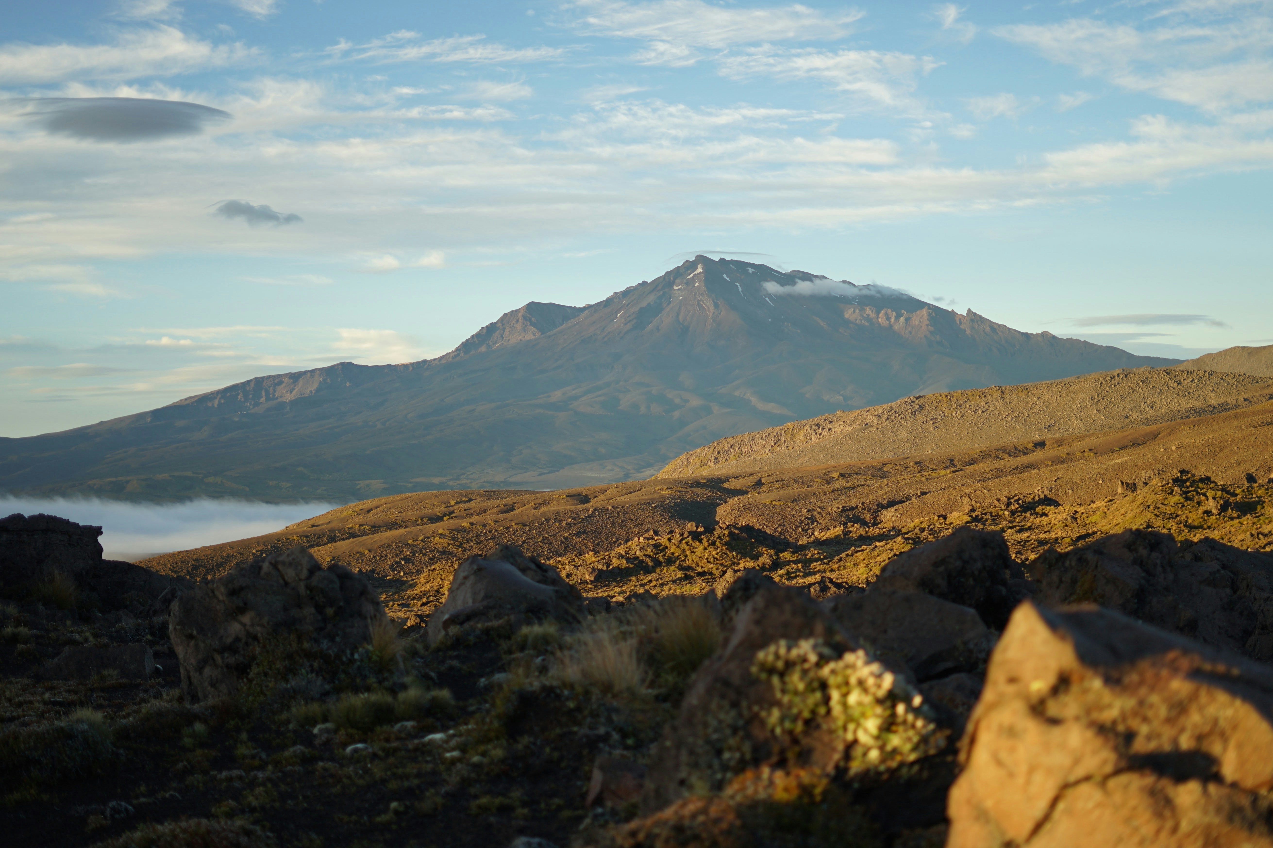
The trail is a masterclass in geographical diversity. Walkers begin in the humid, green rolling hills of the Basque Country, where the Atlantic influence brings frequent mist and verdant pastures. As the route moves eastward into Navarre and Aragon, the landscape transforms into a high-altitude wilderness of limestone massifs, glacial cirques, and turquoise tarns (ibones). The central section passes through the Ordesa y Monte Perdido National Park and the Posets-Maladeta Natural Park, home to the highest peaks in the range. Finally, the trail descends through the volcanic landscapes of Garrotxa and the Mediterranean scrubland of the Albera Massif before reaching the rocky cliffs of the Costa Brava. For those seeking a true thru-hiking challenge that combines physical rigour with deep cultural immersion, the GR11 stands as the ultimate European mountain pilgrimage.
- Distance: 840.0 km
- Total Elevation Gain: 39,000 m
- Duration: 40–50 days
- Difficulty: Challenging (High-altitude terrain, significant daily ascent)
- Best Time: June to September (Summer months)
- Highest Point: Paso de los Caballos / Collado de Tebarray (approx. 2,700 m)
- Start Point: Hondarribia (Cabo Higuer), Gipuzkoa
- End Point: El Port de la Selva (Cap de Creus), Girona
- Markings: Red and white blazes (GR standard)
Overview
The GR11 is a trail of contrasts and endurance. Unlike many coastal or lowland trails, the Senda Pirenaica stays consistently high, frequently crossing passes (collados) exceeding 2,500 metres. This means that even in the height of summer, hikers must be prepared for alpine conditions, including lingering snowfields in June and violent afternoon thunderstorms in August. The route is traditionally walked from West to East, following the prevailing weather patterns and allowing hikers to build their "mountain legs" in the slightly lower Basque mountains before tackling the formidable central Pyrenees of Aragon.
The trail is divided into roughly 45 to 47 stages, though fit hikers often combine sections or take rest days in the many historic mountain villages that the trail intersects. These villages—such as Isaba, Sallent de Gállego, Benasque, and Vielha—provide essential resupply points and a glimpse into the unique Pyrenean culture, where Romanesque architecture and ancient pastoral traditions still thrive. The hospitality in the "Refugios" (mountain huts) is a hallmark of the experience, offering communal meals and a shared sense of purpose among hikers from around the globe.
Physically, the GR11 is relentless. A typical day involves a steep climb of 800 to 1,200 metres in the morning to reach a pass, followed by an equally steep descent into a new valley for the evening. The terrain varies from soft forest tracks and grassy meadows to technical scree slopes and boulder fields. Navigation requires constant attention, as the red and white markings can be obscured by fog or lost in rocky sections. However, the reward for this effort is unparalleled: the sight of the Brecha de Rolando, the towering walls of the Ordesa Canyon, the granite spires of Aigüestortes, and the eventual, emotional sight of the Mediterranean blue after weeks in the high peaks.
History and Cultural Context
The Pyrenees have served as both a barrier and a bridge between the Iberian Peninsula and the rest of Europe for millennia. The GR11 follows many paths that were originally forged by shepherds, smugglers, and pilgrims. For centuries, the "transhumance"—the seasonal movement of livestock between summer mountain pastures and winter valleys—dictated the rhythm of life here. Many of the stone-paved paths and "hospitales" (ancient inns) encountered on the trail are remnants of this pastoral history.
The formalisation of the GR11 as a continuous long-distance route began in the late 1970s and early 1980s, spearheaded by the FEDME (Spanish Federation for Mountain and Climbing Sports). The goal was to create a Spanish equivalent to the French GR10, showcasing the unique landscapes and biodiversity of the southern Pyrenean slopes. Unlike the French side, which is often greener and more forested, the Spanish side is generally sunnier, more rugged, and features more dramatic limestone formations, particularly in the central sector.
Culturally, the trail traverses four distinct regions: the Basque Country (Euskadi), Navarre, Aragon, and Catalonia. Each region brings its own language (Euskera, Aragonese, and Catalan alongside Spanish), distinct culinary specialities, and architectural styles. Hikers will pass through the heart of the Kingdom of Aragon, see the influence of the Camino de Santiago in Navarre, and witness the fierce regional pride of Catalonia. The trail also touches on the history of the Spanish Civil War, as these mountains were the site of desperate escapes and guerrilla resistance. Today, the GR11 is a symbol of trans-Pyrenean cooperation and a vital artery for sustainable mountain tourism in some of Spain's most remote rural areas.
Want more background? Read extended notes on history and cultural context → Learn more
Seasonal Highlights and Weather Reality
The window for completing a full thru-hike of the GR11 is relatively narrow due to the high altitude of the central passes. For most hikers, the season runs from mid-June to late September. Outside of this window, heavy snow makes many sections impassable without advanced mountaineering equipment and skills.
June: This is the month of transition. The valleys are bursting with wildflowers and the waterfalls are at their most powerful due to snowmelt. However, many passes above 2,300 metres will still hold significant snow. Hikers in June must carry an ice axe and crampons (or micro-spikes) and be proficient in self-arrest. The weather can be unpredictable, with late-season snowstorms possible.
July and August: This is the peak season. The snow has mostly cleared from the main trail, and the mountain huts are fully operational. These months offer the most stable weather, but they also bring the heat. In the lower sections of the Basque Country and Catalonia, temperatures can exceed 30°C. In the high mountains, the primary threat is the "tormenta"—violent afternoon thunderstorms that develop rapidly. Hikers should aim to cross high passes before 2:00 PM to avoid being caught on exposed ridges during lightning strikes.
September: Many experienced hikers consider this the best time for the GR11. The crowds of August have thinned, the air is crisp and clear, and the autumn colours begin to touch the beech and birch forests. The weather is generally more stable than in mid-summer, though the days are shorter and the nights at high-altitude campsites or huts can drop below freezing. By late September, the first dustings of winter snow often appear on the highest peaks, signalling the end of the trekking season.
Winter (October to May): The GR11 becomes a serious winter mountaineering undertaking. Many huts close or leave only a basic winter shelter open. Navigation becomes extremely difficult as trail markings are buried under metres of snow. Only those with extensive winter experience and avalanche training should attempt sections of the trail during this time.
Recommended Itinerary
The 45-Day Senda Pirenaica Traverse
Stage 1: The Basque Country (Days 1–7)
- Route: Cabo Higuer (Hondarribia) to Isaba
- Distance: Approx. 130 km
- Key Waypoints: Bera, Elizondo, Puerto de Ibañeta, Ochagavía
- Terrain: Rolling green hills, Atlantic forests, and the first limestone outcrops of Navarre
- Highlights: Starting at the lighthouse at Cape Higuer; the historic pass of Roncesvalles (shared with the Camino de Santiago); the beautiful stone villages of the Baztan Valley
- Note: Often misty and humid; lower elevations but significant cumulative gain
Stage 2: Western Aragon and Ordesa (Days 8–16)
- Route: Isaba to Goriz Hut
- Distance: Approx. 140 km
- Key Waypoints: Zuriza, Candanchú, Sallent de Gállego, Panticosa, Bujaruelo
- Terrain: High alpine limestone, glacial valleys, and dramatic canyons
- Highlights: The Selva de Oza; the transition into the high Pyrenees; the spectacular Ordesa Canyon (a UNESCO World Heritage site); staying at the iconic Goriz Hut beneath Monte Perdido
- Note: This section contains some of the most famous scenery in the entire range
Stage 3: The Central High Pyrenees (Days 17–25)
- Route: Goriz Hut to Vielha
- Distance: Approx. 120 km
- Key Waypoints: Añisclo Canyon, Pineta Valley, Parzán, Benasque, Hospital de Benasque
- Terrain: Rugged granite massifs, high passes (Collado de Añisclo), and the highest peaks (Aneto and Posets nearby)
- Highlights: The descent into the Pineta Valley; the remote and wild Gistain Valley; the bustling mountain town of Benasque; crossing into Catalonia via the Mulleres pass or the Vielha tunnel route
- Note: The most physically demanding section with the highest average altitude
Stage 4: Aigüestortes and the Catalan Lakes (Days 26–34)
- Route: Vielha to Puigcerdà
- Distance: Approx. 160 km
- Key Waypoints: Sant Maurici, Espot, La Guingueta d'Àneu, Tavascan, Areu, Andorra (Arinsal/Encamp)
- Terrain: A landscape defined by hundreds of glacial lakes and jagged granite needles
- Highlights: Aigüestortes i Estany de Sant Maurici National Park; the "Encantats" peaks; the remote border country of the Pica d'Estats; traversing the high valleys of Andorra
- Note: Excellent hut system but requires careful booking in the National Park
Stage 5: The Eastern Pyrenees and Garrotxa (Days 35–41)
- Route: Puigcerdà to Setcases
- Distance: Approx. 110 km
- Key Waypoints: Planoles, Nuria, Ulldeter
- Terrain: Softer, rounded peaks (The "Pyrenees of Light") and deep forested valleys
- Highlights: The high-altitude sanctuary of Vall de Núria (accessible only by rack railway or foot); the ascent of Costabona; the transition from alpine to Mediterranean flora
- Note: Still high (Nuria is at 1,964 m), but the terrain becomes less technical
Stage 6: The Mediterranean Finish (Days 42–45)
- Route: Setcases to Cap de Creus
- Distance: Approx. 140 km
- Key Waypoints: Beget, Albanyà, La Jonquera, Requesens, El Port de la Selva
- Terrain: Volcanic hills, cork oak forests, and finally, the rocky Mediterranean coast
- Highlights: The medieval village of Beget; the Albera mountains; the monastery of Sant Pere de Rodes; the final descent to the sea at Cap de Creus
- Note: Can be very hot; water sources become scarcer; the "Tramuntana" wind can be fierce
Important Notes:
- The itinerary is flexible; many hikers take 50 days to allow for rest and weather delays
- Resupply is possible every 3–4 days in villages
- Wild camping is permitted in many areas but strictly regulated in National Parks
- Always have a "Plan B" for high passes in case of bad weather
Planning and Bookings
Book Your Trip
Everything you need to plan your journey
Accommodation
Find places to stay near Barcelona
Flights
Search flights to Barcelona
Essential Preparation
The GR11 is a serious undertaking that requires significant physical and logistical preparation. Fitness is the most critical factor; you should be comfortable walking 20–25 kilometres a day with 1,000 metres of ascent while carrying a 10–12 kg pack. Training should focus on weighted hill climbs and back-to-back hiking days to toughen the feet and joints.
Logistically, you must decide whether to walk the entire trail in one go or in sections. For a full thru-hike, starting in the West (Hondarribia) is recommended to allow for acclimatisation. Base cities for the start include San Sebastian or Biarritz. For the central sections, Benasque and Jaca are excellent hubs. You will need to coordinate your start date with the snow conditions—starting too early (May) will result in being blocked by snow in the high Aragon passes by week three.
Trail Accommodation
The GR11 offers a mix of "Refugios" (staffed mountain huts), "Refugios libres" (unstaffed basic shelters), hostals in villages, and camping.
Staffed Refugios: These are generally open from mid-June to mid-September. They provide a bunk in a communal room, dinner, and breakfast.
- Facilities: Mattresses, blankets (usually), toilets, showers (often paid/limited), and communal dining.
- Booking: Essential in July and August, especially in Ordesa and Aigüestortes. Many can be booked through the "Refugios de Aragón" or "Federació d'Entitats Excursionistes de Catalunya" websites.
- Costs: Approximately €40–€60 for half-board (dinner, bed, breakfast). Discounts apply for Alpine Club members (UIAA).
- What's NOT provided: Towels, toiletries, earplugs (essential for dorms), and charging points are often limited or solar-powered.
Unstaffed Shelters: These are basic stone huts with no facilities other than a roof and sometimes a wooden platform. They are free and cannot be booked. Use them as emergency backups or for a more rugged experience.
Camping: Wild camping is generally allowed above the treeline (usually 1,500 m or 2,000 m depending on the region) from sunset to sunrise. However, in National Parks like Ordesa and Aigüestortes, it is either strictly forbidden or only allowed in very specific zones near huts. Always check local regulations.
Required Gear
- Footwear: High-quality trekking boots or trail runners with excellent grip (Vibram soles recommended). Ensure they are well broken-in.
- Backpack: 40–55 litres with a comfortable harness and rain cover. Keep total weight under 12 kg if possible.
- Clothing: Layering system is key. Merino wool base layers, a fleece or down mid-layer, and a high-quality waterproof/breathable shell (Gore-Tex).
- Navigation: GPS device or smartphone with offline maps (Gaia GPS, Wikiloc, or Komoot). Physical maps (Editorial Alpina 1:25,000 or 1:40,000) are highly recommended as backups.
- Safety Gear: Emergency whistle, space blanket, first aid kit (focus on blister care), and a multi-tool.
- Sleeping: A lightweight sleeping bag (comfort rating 0°C to 5°C) and a silk liner for huts. If camping, a lightweight tent and insulated mat.
What to Bring
- Water Treatment: A filter (Sawyer Squeeze or Katadyn BeFree) or purification tablets. While water is plentiful, many areas have high livestock density.
- Food: Carry 2–3 days of emergency rations (dehydrated meals, nuts, energy bars). Most hikers buy fresh food in villages every few days.
- Sun Protection: High SPF sunscreen, lip balm with UV protection, polarized sunglasses, and a wide-brimmed hat. The alpine sun is intense.
- Toiletries: Biodegradable soap, travel towel, toothbrush, and hand sanitiser.
- Power: A high-capacity power bank (10,000–20,000 mAh) to keep navigation devices charged between villages.
- Cash: Many remote huts do not accept credit cards. Carry enough Euros to cover several days of hut stays and meals.
Permits
One of the great advantages of the GR11 is that no overarching permit is required to walk the trail. It is a public right of way. However, there are specific regulations you must follow, particularly regarding overnight stays in protected areas.
National Park Regulations:
- Ordesa y Monte Perdido: Camping is strictly regulated. You may only "bivouac" (set up at sunset, take down at sunrise) above 2,100 metres in certain areas, or stay at the Goriz Hut. During peak season, the bus from Torla to the meadow is mandatory as private cars are restricted.
- Aigüestortes i Estany de Sant Maurici: Wild camping is strictly prohibited throughout the park. You must stay in the designated staffed refugios. These book out months in advance for July and August.
Hut Bookings: While not a "permit," booking your spot in the refugios is essential for a smooth trip. In the Central Pyrenees, the huts are often the only legal or practical place to stay. Use the centralised booking portals for the Aragon and Catalonia regions. If you arrive at a full hut without a booking, they are legally required to provide emergency shelter (often on a dining room floor), but this is uncomfortable and should be avoided.
Fishing and Hunting: If you plan to fish in the mountain lakes (ibones), you must obtain a regional license for Navarre, Aragon, or Catalonia. Hunting is strictly regulated and generally occurs in the autumn; hikers should wear bright colours if walking during hunting season in the lower valleys.
Other Activities in the Area
The Pyrenees offer a wealth of experiences beyond the GR11 trail itself. If you have extra time or want to take a "zero day," consider these options:
- Summiting Aneto: At 3,404 metres, Aneto is the highest peak in the Pyrenees. From the GR11 near Benasque, you can take a two-day detour to climb it. Note: This requires crossing a glacier and necessitates an ice axe and crampons.
- Canyoning in Sierra de Guara: Located just south of the main Pyrenean axis, this area offers some of the best canyoning in Europe, with turquoise water and spectacular limestone gorges.
- Romanesque Art Tour: The Vall de Boí (near the trail in Catalonia) is home to a group of nine early Romanesque churches, designated as a UNESCO World Heritage site. Their architecture and murals are breathtaking.
- Andorra Shopping and Spas: The trail passes directly through Andorra. Take a break in Andorra la Vella for duty-free shopping or visit Caldea, one of Europe's largest thermal spa complexes.
- Wine Tasting: As you reach the Mediterranean end of the trail in the Empordà region, visit local vineyards to sample excellent Catalan wines and olive oils.
- Bird Watching: The Pyrenees are one of the best places in Europe to see large raptors, including the Lammergeier (Bearded Vulture), Griffon Vulture, and Golden Eagle.
Safety and Conditions
Weather Awareness: The Pyrenees are notorious for rapid weather changes. A sunny morning can turn into a dangerous storm by mid-afternoon. Always check the forecast (AEMET is the Spanish national weather service) before setting out. If you see dark, towering cumulus clouds forming, seek lower ground immediately. Avoid high passes and ridges during thunderstorms.
Terrain Hazards: The GR11 involves significant amounts of "scree" (loose rock) and boulder hopping. This is hard on the ankles and knees. Trekking poles are highly recommended to improve stability and reduce impact. In early summer, steep snow slopes are the primary hazard; do not attempt to cross them without the proper equipment and knowledge of how to use it.
Water and Hydration: While there are many streams, the Pyrenees are heavily grazed by cattle and sheep. Water should always be treated. In the eastern sections (Catalonia), water sources can dry up in late summer, so carry extra capacity (at least 3 litres).
Navigation: While the trail is marked with red and white blazes, these can be sparse in rocky areas or hidden by snow and fog. Always carry a GPS with offline maps and know how to use a map and compass. Getting lost in a high-altitude cirque as night falls is a serious survival situation.
Emergency Services: The emergency number in Spain is 112. Mountain rescue (GREIM) is highly professional but should only be called in genuine emergencies. Mobile phone coverage is non-existent in many deep valleys and high passes; carrying a satellite messenger (like a Garmin inReach) is a wise investment for solo thru-hikers.
Side Trips and Points of Interest
Monte Perdido (3,355 m): Accessible from the Goriz Hut, this is the third-highest peak in the Pyrenees. The "Escupidera" (the final slope) is famous for being dangerous in icy conditions, but in late summer, it is a challenging but non-technical scramble for fit hikers.
The Brecha de Rolando: A massive natural gap in the cliff walls of the Cirque de Gavarnie, located on the border between Spain and France. It is a short but steep detour from the GR11 near Goriz and offers one of the most iconic views in the entire mountain range.
Cola de Caballo Waterfall: Located at the head of the Ordesa Valley, this "Horse's Tail" waterfall is a spectacular sight. The GR11 passes nearby, but taking the "Senda de los Cazadores" (Hunter's Path) provides a stunning aerial view of the entire canyon.
Estany de Sant Maurici: This lake, with the twin peaks of Els Encantats reflecting in its waters, is the postcard image of the Catalan Pyrenees. The GR11 passes right along its shores, making it an ideal spot for a long lunch break.
Sant Pere de Rodes: On the final day of the trail, this former Benedictine monastery sits high above the Mediterranean. The views of the coast from its ruins are the perfect reward for 800 kilometres of walking.
Leave No Trace
The Pyrenees are a fragile ecosystem under increasing pressure from climate change and tourism. As a GR11 hiker, you have a responsibility to minimise your impact on this magnificent landscape.
Core Principles for the GR11:
- Pack it in, pack it out: This includes all trash, even organic waste like orange peels or apple cores, which decompose slowly in the thin alpine air and can harm local wildlife.
- Respect the "Bivouac" rules: If camping, set up your tent at dusk and take it down at dawn. Avoid camping near fragile lake margins or in meadows filled with wildflowers.
- Manage human waste: Use the toilets in huts and villages whenever possible. If you must go on the trail, dig a "cathole" at least 15 cm deep and 60 metres away from water sources. Pack out your toilet paper in a sealed bag.
- Keep wildlife wild: Never feed marmots, foxes, or birds. Store your food securely at night to avoid attracting animals to your campsite.
- Stick to the path: In alpine meadows, "social trails" can cause significant erosion. Stay on the marked GR11 route to protect the thin topsoil.
- No fires: Wildfires are a massive risk in Spain, especially in the drier eastern Pyrenees. Use a lightweight camping stove for cooking and never light an open fire.