GR10: The Great Traverse of the Pyrenees
The GR10 (Grande Randonnée 10) is one of Europe’s most iconic and demanding long-distance trekking routes, offering a complete horizontal traverse of the French Pyrenees. Stretching approximately 866 kilometres from the crashing Atlantic surf of Hendaye in the west to the sun-drenched Mediterranean shores of Banyuls-sur-Mer in the east, this trail is a monumental undertaking of physical endurance and mental fortitude. Unlike the high-altitude HRP (Haute Randonnée Pyrénéenne) which stays on the crest, the GR10 weaves through the valleys and over the passes, plunging into mountain villages and climbing back into alpine wilderness with relentless regularity. This "yo-yo" profile results in a staggering total elevation gain of approximately 55,000 metres—the equivalent of climbing Mount Everest from sea level more than six times. For the thru-hiker, the GR10 is more than a walk; it is a two-month immersion into the distinct cultures of the Pays Basque, Béarn, Bigorre, Ariège, and Catalonia, all while navigating some of the most spectacular mountain scenery in Western Europe.
- Distance: 866 km one-way
- Duration: 45–60 days
- Season: June to September (high passes often snow-bound until late June)
- Accommodation: Gîtes d'étape, mountain refuges, and wild camping (where permitted)
- Highest point: Hourquette d'Ossoue (2,734 m)
- Total Elevation Gain: 55,000 m
- Direction: Traditionally West to East (Hendaye to Banyuls-sur-Mer)
Overview
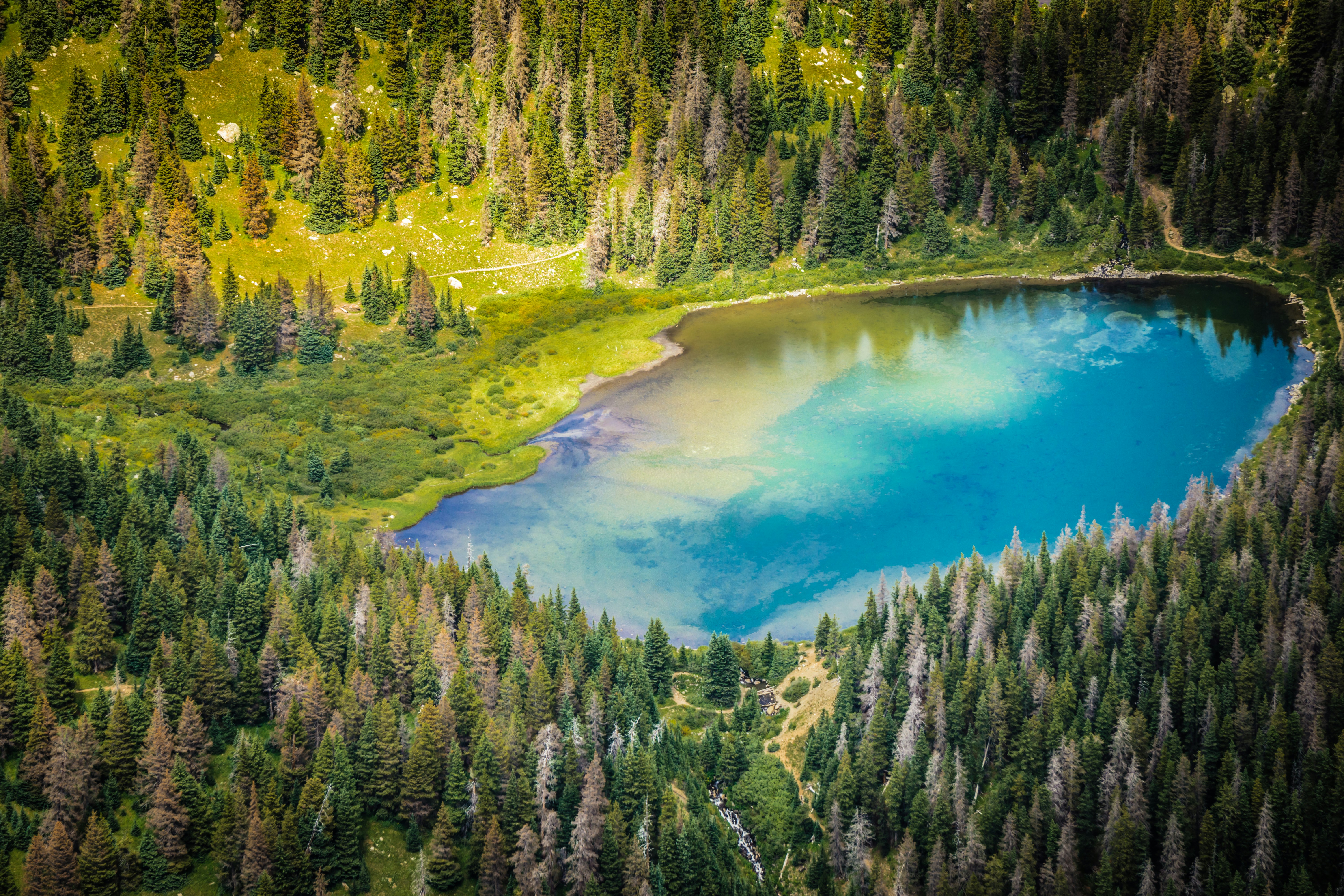
The GR10 is a trail defined by its verticality. While many long-distance trails follow ridges or plateaus, the GR10 is famous for its daily cycle of descending into a valley for supplies or a bed, only to climb 1,000 metres or more back over a col the following morning. This constant movement between the high alpine zone and the lush, inhabited valleys provides a unique trekking experience where wild nature and pastoral culture are inextricably linked. You will transition from limestone peaks and glacial cirques to ancient beech forests, fern-covered hillsides, and medieval stone villages within a single day's march.
The journey is typically divided into several distinct geographical and cultural regions. It begins in the Basque Country (Pays Basque), where the mountains are lower but the gradients are surprisingly steep, and the Atlantic influence brings frequent mist and rain. As you move east into the Béarn and Bigorre regions, the landscape transforms into the "High Pyrenees," home to the range's most famous peaks like the Vignemale and the Pic du Midi d'Ossau. Here, the trail reaches its highest altitudes, crossing rugged granite passes and skirting turquoise glacial lakes. The central section through the Ariège is widely considered the most challenging; the terrain is wilder, the path is often narrower and more overgrown, and the sense of isolation is profound. Finally, the trail enters the Pyrénées-Orientales, where the air becomes drier, the vegetation shifts to Mediterranean scrub and cork oaks, and the iconic silhouette of Le Canigou signals the final descent to the sea.
Walking the GR10 requires a high level of fitness and a deep appreciation for the slow pace of mountain travel. It is not a trail for those in a hurry. The rewards are found in the shifting light on the granite walls of the Cirque de Gavarnie, the taste of fresh sheep’s cheese (Ossau-Iraty) purchased directly from a shepherd, and the profound sense of accomplishment that comes from crossing an entire mountain range on foot. Whether you tackle it in one continuous push or in sections over several years, the GR10 remains a benchmark for European trekking.
History and Cultural Context
The GR10 is a cornerstone of the French "Grande Randonnée" network, a system of long-distance paths conceived in the mid-20th century to encourage the exploration of the French countryside. The concept was pioneered by Jean Loiseau, who founded the Comité National des Sentiers de Grande Randonnée in 1947. The GR10 itself was developed throughout the 1960s and 1970s, linking existing shepherd paths, Roman roads, and old smuggling routes into a continuous traverse. Unlike the Spanish GR11, which was developed later, the GR10 was designed to stay within French territory, showcasing the diversity of the northern slopes of the Pyrenees.
Culturally, the trail is a tapestry of distinct identities. In the west, the Basque people have inhabited these mountains for millennia, maintaining a language (Euskara) and traditions that pre-date the Indo-European migration. Their white-washed houses with red or green shutters are a hallmark of the first week of the trek. Moving east, the pastoral traditions of the Béarn and Ariège remain strong. You will frequently encounter "transhumance"—the seasonal movement of livestock to high summer pastures. The sound of cowbells and the sight of "cabanes" (shepherd huts) are constant companions. In the east, the Catalan influence takes over, with its own unique language, flag, and architectural style, culminating in the coastal vineyards of the Mediterranean.
The Pyrenees have also served as a historical barrier and a refuge. During World War II, these mountains were crossed by thousands of people escaping occupied France via "Chemins de la Liberté" (Freedom Trails). Many sections of the GR10 overlap with these historic escape routes, adding a layer of somber historical significance to the physical challenge of the hike. Today, the trail is maintained by dedicated volunteers from the FFRandonnée (Fédération Française de la Randonnée Pédestre), ensuring that the red-and-white blazes remain a reliable guide for modern adventurers.
Want more background? Read extended notes on history and cultural context → Learn more
Seasonal Highlights and Weather Reality
The window for a full thru-hike of the GR10 is relatively narrow, dictated by the presence of snow on the high passes. Most hikers begin in June and aim to finish by September. However, weather in the Pyrenees is notoriously fickle and can change with startling speed.
June: This is the month of "névés" (lingering snow patches). While the lower Basque hills are lush and green, the high passes in the central Pyrenees (above 2,000 metres) often require an ice axe and crampons until late June or even early July. The days are long, and the wildflowers are at their peak, but hikers must be prepared for cold temperatures and difficult navigation in snow-covered sections.
July and August: This is the peak season. The snow has mostly melted, and all mountain refuges are fully operational. However, these months bring two major challenges: heat and thunderstorms. Temperatures in the valleys can exceed 30°C, making the long climbs punishing. Afternoon thunderstorms ("orages") are common and can be violent, with heavy rain, hail, and lightning. Hikers are advised to start early and aim to be over the day's highest pass by midday.
September: Many experienced hikers consider this the best time to be on the GR10. The summer crowds have thinned, the air is crisp and clear, and the autumn colours begin to touch the beech forests. The risk of thunderstorms decreases, though the days are shorter and the nights become significantly colder. By late September, the first dustings of winter snow can appear on the high peaks, and some refuges begin to close or move to winter mode.
Winter (October to May): The GR10 is not a hiking trail in winter; it is a serious mountaineering and ski-touring undertaking. High avalanche risk, buried trail markings, and extreme cold make it impassable for standard trekking. Only the lowest sections in the Basque Country or the Mediterranean coast remain accessible to hikers during these months.
Recommended Itinerary
The 50-Day GR10 Traverse
Stage 1: The Basque Country (Hendaye to Saint-Jean-Pied-de-Port)
- Distance: ~120 km
- Duration: 6–7 days
- Key Waypoints: Hendaye, Sare, Ainhoa, Bidarray, Saint-Étienne-de-Baïgorry
- Character: Rolling green hills, steep grassy ridges, and Atlantic mists. The elevation is lower (max ~1,000 m), but the constant short, sharp climbs are a "wake-up call" for the legs.
- Highlights: The summit of La Rhune and the medieval streets of Saint-Jean-Pied-de-Port.
Stage 2: The Béarn and High Aspe Valley (Saint-Jean-Pied-de-Port to Lescun)
- Distance: ~100 km
- Duration: 5–6 days
- Key Waypoints: Iraty, Logibar, Sainte-Engrâce, Lescun
- Character: Transitioning into the limestone Pyrenees. The terrain becomes more rugged, and the first truly alpine vistas appear.
- Highlights: The Holzarté footbridge (suspended 150 m above a gorge) and the "Cirque de Lescun" with its dolomitic limestone spires.
Stage 3: The High Pyrenees (Lescun to Cauterets)
- Distance: ~90 km
- Duration: 5–6 days
- Key Waypoints: Gabas, Gourette, Arrens-Marsous, Cauterets
- Character: This is the heart of the range. You will cross high granite passes and enter the Parc National des Pyrénées.
- Highlights: Views of the Pic du Midi d'Ossau and the descent into the elegant spa town of Cauterets.
Stage 4: The Bigorre and Gavarnie (Cauterets to Bagnères-de-Luchon)
- Distance: ~130 km
- Duration: 7–8 days
- Key Waypoints: Luz-Saint-Sauveur, Gavarnie, Saint-Lary-Soulan, Loudenvielle
- Character: Home to the highest point of the trail (Hourquette d'Ossoue). The scenery is world-class, featuring massive glacial cirques and high-altitude lakes.
- Highlights: The Cirque de Gavarnie (a UNESCO World Heritage site) and the Réserve Naturelle de Néouvielle.
Stage 5: The Wild Ariège (Bagnères-de-Luchon to Mérens-les-Vals)
- Distance: ~180 km
- Duration: 10–12 days
- Key Waypoints: Fos, Eylie, Aunac, Guzet-neige, Siguer
- Character: The most remote and physically demanding section. The path is often steep, rocky, and less maintained. Resupply points are fewer and further between.
- Highlights: The Étang de Lers and the rugged beauty of the Mont Valier area.
Stage 6: The Pyrénées-Orientales and Catalonia (Mérens-les-Vals to Banyuls-sur-Mer)
- Distance: ~240 km
- Duration: 12–14 days
- Key Waypoints: Les Bouillouses, Planès, Py, Mantet, Arles-sur-Tech, Banyuls
- Character: The landscape becomes drier and more Mediterranean. The final challenge is the massif of Le Canigou before the long descent through vineyards to the sea.
- Highlights: The high plateau of Cerdagne, the summit of Le Canigou, and the first sight of the Mediterranean.
Important Notes:
- The itinerary is highly flexible; most hikers adjust based on weather and fatigue.
- Resupply is possible every 2–4 days in valley villages.
- Water is generally abundant but must be treated due to livestock.
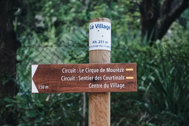
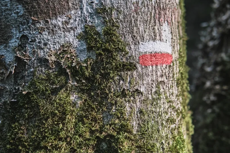
- The red-and-white blazes are generally excellent, but a map and compass/GPS are essential for mist or snow.
Planning and Bookings
Book Your Trip
Everything you need to plan your journey
Accommodation
Find places to stay near Toulouse
Flights
Search flights to Toulouse
Essential Preparation
Planning a GR10 thru-hike requires significant logistical coordination. Unlike a shorter trail, you cannot carry all your food from the start. You must identify resupply points (supermarkets, small village épiceries, or post offices for bounce boxes). Fitness is the most critical preparation; you should be comfortable walking 15–25 kilometres per day with 1,000+ metres of elevation gain for multiple consecutive days. Training with a weighted pack is essential.
Logistically, the trail is well-served by public transport at the ends. Biarritz (BIQ) is the nearest airport for the western trailhead at Hendaye, with easy train connections. For the eastern end at Banyuls-sur-Mer, trains run regularly to Perpignan and onwards to Barcelona or Paris. Toulouse serves as a central hub for those wishing to start or end in the middle of the range.
Trail Accommodation
The GR10 offers a variety of accommodation options, allowing for different styles of trekking, from "civilised" hut-to-hut hiking to rugged wild camping.
Gîtes d'étape: Located in villages, these are specifically designed for hikers. They offer dormitory-style beds, hot showers, and often a "demi-pension" (half-board) option including dinner and breakfast. Costs typically range from €40 to €60 for half-board. Booking is highly recommended in July and August.
Refuges: These are high-altitude mountain huts, often managed by the CAF (Club Alpin Français). They are more basic than gîtes but provide essential shelter in the high mountains. Facilities include dormitories, common dining areas, and basic toilets. Some have hot showers (for a fee), while others are more primitive. Booking is essential as they have limited capacity.
Camping and Bivouacking: Wild camping (bivouacking) is generally permitted along the GR10, but with strict rules. In the Parc National des Pyrénées, you may only pitch a tent between 7:00 PM and 9:00 AM and must be at least one hour's walk from a road or park boundary. Outside the National Park, rules vary by commune, but the "sunset to sunrise" rule is a good standard to follow. Many gîtes and refuges also allow camping on their grounds for a small fee, giving you access to their facilities.
Required Gear
- Footwear: High-quality trekking boots with good ankle support and a stiff sole for rocky terrain. Ensure they are well broken-in before starting.
- Backpack: A 50–65 litre pack is standard for a thru-hike. It must have a robust harness system to manage the weight of food and water.
- Rain Gear: A high-end waterproof jacket (Gore-Tex or similar) and overtrousers. Pyrenean storms are intense.
- Navigation: Topographic maps (IGN 1:25,000 are the gold standard), a compass, and a GPS device or smartphone with offline maps (e.g., Gaia GPS or AllTrails).
- Sleeping System: A lightweight 3-season sleeping bag (comfort rating 0°C to 5°C) and a sleeping mat if camping. Even in summer, high-altitude nights are cold.
- Trekking Poles: Highly recommended to save your knees during the 55,000 metres of descent.
What to Bring
- Water Treatment: A filter (e.g., Sawyer Squeeze) or purification tablets. While mountain streams look clear, the presence of sheep and cattle makes treatment mandatory.
- Sun Protection: High SPF sunscreen, a wide-brimmed hat, and category 3 or 4 sunglasses. The alpine sun is fierce.
- Clothing Layers: Merino wool base layers, a fleece or down mid-layer, and quick-drying trekking trousers. Avoid cotton.
- First Aid: Blister kits (Compeed), antiseptic wipes, painkillers, and any personal medications.
- Power: A large capacity power bank (20,000mAh) to keep your navigation devices charged between villages.
- Food: Always carry at least 2 days of emergency rations. High-calorie, lightweight options like nuts, dried fruit, and dehydrated meals are best.
Permits
One of the great joys of the GR10 is the lack of a formal permit system for the trail itself. There is no "thru-hiker permit" required to walk from the Atlantic to the Mediterranean, and there are no daily quotas for the trail. This allows for a high degree of spontaneity and flexibility in your itinerary.
National Park Regulations: While no permit is needed to enter the Parc National des Pyrénées, you must adhere to strict regulations designed to protect the environment. These include no fires, no dogs (even on a lead) in the core zone, and the specific bivouac hours mentioned in the accommodation section. Rangers do patrol these areas, and fines for non-compliance are common.
Accommodation Bookings: While not a "permit," booking your beds in advance is the closest you will come to a mandatory requirement during the peak months of July and August. Popular refuges like the Refuge d'Oulettes de Gaube or the Refuge de Bayssellance can book out months in advance. If you are not carrying a tent, your itinerary will be strictly dictated by hut availability.
Fishing and Hunting: If you plan to fish in the mountain lakes, you must purchase a French fishing licence (carte de pêche), which can be bought online or in local tabacs. Hunting is strictly regulated and generally occurs in the autumn; hikers should be aware of local hunting zones during this time.
Other Activities in the Area
The Pyrenees offer a wealth of experiences beyond the trail. If you have extra time or need a rest day, consider these options:
- Thermal Spas: The Pyrenees are famous for their natural hot springs. Towns like Cauterets, Luz-Saint-Sauveur, and Ax-les-Thermes have elegant thermal baths where you can soak your tired muscles in mineral-rich waters.
- Canyoning and Rafting: The steep valleys of the Béarn and Ariège offer some of Europe’s best white-water sports. Professional guides in towns like Argelès-Gazost can take you into spectacular gorges.
- The Little Yellow Train (Le Petit Train Jaune): In the Pyrénées-Orientales, this historic narrow-gauge railway climbs from Villefranche-de-Conflent to Latour-de-Carol, offering stunning views of the Cerdagne plateau.
- Gastronomy Tours: Each valley has its own culinary specialities. Don't miss the chance to visit a "fromagerie" to see how mountain cheese is made, or enjoy a "Garbure" (a thick Pyrenean vegetable and meat soup) in a local auberge.
- Paragliding: The thermal currents of the Pyrenees make it a world-class destination for paragliding. Tandem flights are available in many locations, including Loudenvielle and Accous.
Safety and Conditions
Weather Awareness: The most significant objective hazard on the GR10 is the weather. Afternoon thunderstorms are a daily possibility in summer. These are not merely rain showers; they involve intense lightning and rapid temperature drops. Always check the "Météo France" mountain forecast (Météo Montagne) before setting out. If a storm is predicted, ensure you are off the high ridges and passes by early afternoon.
Navigation: While the GR10 is generally well-marked with red-and-white stripes, markings can be obscured by fog, snow, or overgrown vegetation (especially in the Ariège). In the Basque Country, sea mists (brouillard) can reduce visibility to a few metres in minutes. Never rely solely on trail markings; always have a map and compass and know how to use them.
Livestock and Guard Dogs: You will frequently walk through active grazing lands. You may encounter "Patous"—large white Great Pyrenees dogs used to protect sheep from wolves and bears. These dogs are not pets; they are working animals. If you encounter a flock guarded by a Patou, do not approach the sheep. Walk in a wide circle around the flock, keep your trekking poles down, and speak in a calm, low voice. Do not try to pet the dog or feed it.
Terrain: The GR10 is a rugged mountain trail. Expect loose scree, steep grassy slopes that are slippery when wet, and occasional easy scrambling. The descent from the Hourquette d'Ossoue towards Gavarnie, for example, involves navigating rocky terrain that requires steady footing. Ensure your first aid kit includes supplies for sprains and strains.
Emergency Services: The universal emergency number in France is 112. However, mobile signal is non-existent in many deep valleys and high passes. Carrying a Personal Locator Beacon (PLB) or a satellite messenger (like a Garmin inReach) is highly recommended for thru-hikers.
Side Trips and Points of Interest
Pic du Midi d'Ossau: While the GR10 doesn't summit this iconic volcanic tooth, the trail provides some of the best views of it from the Col d'Ayous. A popular side trip is to spend an extra night at the Refuge d'Ayous to watch the sunset reflect the peak in the surrounding lakes.
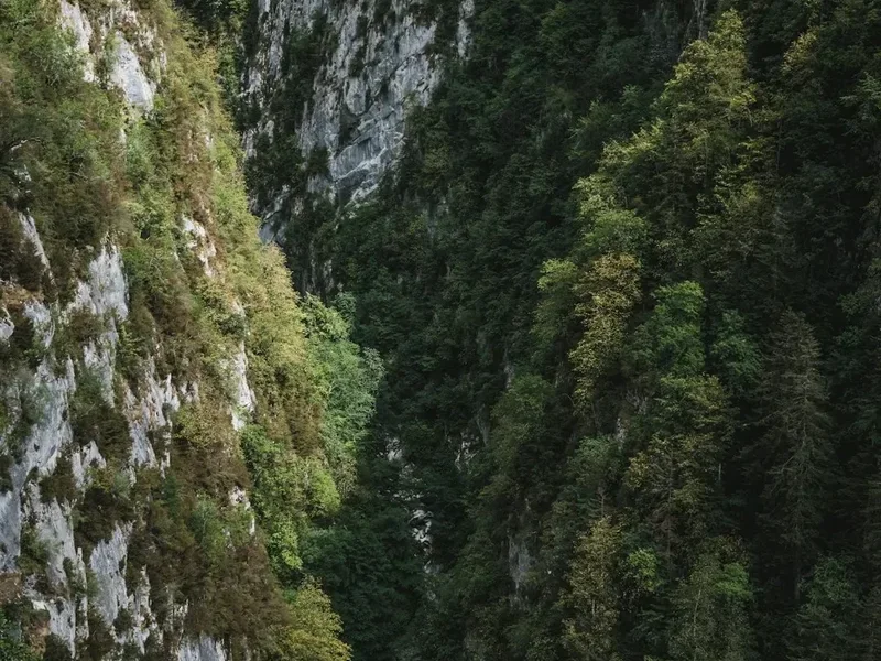
Cirque de Gavarnie: This is perhaps the most famous sight in the Pyrenees. A massive limestone amphitheatre with walls rising 1,500 metres, it features the Grande Cascade, one of Europe’s highest waterfalls. The GR10 passes right through the heart of this area, but taking a half-day to walk to the base of the falls is a must.
Vignemale and the Glacier d'Ossoue: The GR10 passes beneath the Vignemale (3,298 m), the highest peak in the French Pyrenees. The Refuge de Bayssellance, located on the trail, is the highest guarded refuge in the range and serves as the base for those wishing to summit the peak (requires mountaineering gear and skills).
Le Canigou: The "Sacred Mountain of the Catalans." The GR10 skirts the flanks of this massive peak. Many hikers take a detour to the summit (2,784 m) for a legendary view that, on clear days, stretches from the Mediterranean coast to the high peaks of the central Pyrenees.
Lourdes: While not on the trail, the pilgrimage city of Lourdes is easily accessible by bus or train from Cauterets or Luz-Saint-Sauveur. It offers a fascinating, if crowded, cultural experience and a chance for a "rest day" in a major town.
Leave No Trace
The Pyrenees are a fragile ecosystem under increasing pressure from climate change and tourism. As a GR10 hiker, you have a responsibility to minimise your impact on this ancient landscape.
Waste Management: There is no rubbish collection in the mountains. You must pack out everything you pack in, including organic waste like orange peels and banana skins, which decompose very slowly at high altitudes. For human waste, use the toilets at refuges whenever possible. If you must go on the trail, dig a "cathole" at least 15 cm deep and at least 60 metres from any water source. Pack out your toilet paper in a sealed bag.
Water Protection: Do not use soap (even biodegradable soap) directly in lakes or streams. Carry water 60 metres away from the source for washing. The Pyrenean Desman, a rare aquatic mammal, and various endemic amphibians rely on pristine water quality.
Wildlife Respect: The Pyrenees are home to rare species like the Lammergeier (Bearded Vulture), the Izard (Pyrenean Chamois), and the Marmot. Observe wildlife from a distance. Never feed animals, as this habituates them to humans and can lead to their death. In the National Park, keep noise to a minimum to avoid disturbing nesting birds.
Flora: Stay on the marked path. The alpine tundra and peat bogs you cross are extremely sensitive to trampling. A single shortcut across a switchback can initiate erosion that takes decades to repair.