Gornergrat Trail - The Ultimate Matterhorn Panorama
The Gornergrat Trail is arguably Switzerland's most iconic day hike, offering a continuous, front-row seat to the world’s most recognisable mountain: the Matterhorn. Located in the Valais Alps above the car-free village of Zermatt, this 11.6-kilometre descent (or ascent) traverses a high-alpine landscape of staggering beauty. Starting at the Gornergrat ridge at an altitude of 3,089 metres, the trail winds through a kingdom of rock, ice, and alpine meadows, providing panoramic views of 29 peaks exceeding 4,000 metres, including the Monte Rosa massif and the sprawling Gorner Glacier. Unlike many alpine routes that hide their rewards until the summit, the Gornergrat Trail delivers immediate, high-impact visual drama from the first step, making it a bucket-list experience for hikers visiting the Swiss Alps.
- Distance: 11.6 km (one-way descent from Gornergrat to Zermatt)
- Duration: 4–5 hours
- Elevation Gain: 785 m (if hiking up); Elevation Loss: 1,469 m (if hiking down)
- Difficulty: Moderate (technically straightforward but demanding on knees during descent)
- Highest Point: Gornergrat Kulm (3,089 m)
- Best Time: Late June to September (snow-dependent)
- Trailhead Access: Gornergrat Bahn cogwheel railway from Zermatt
Overview
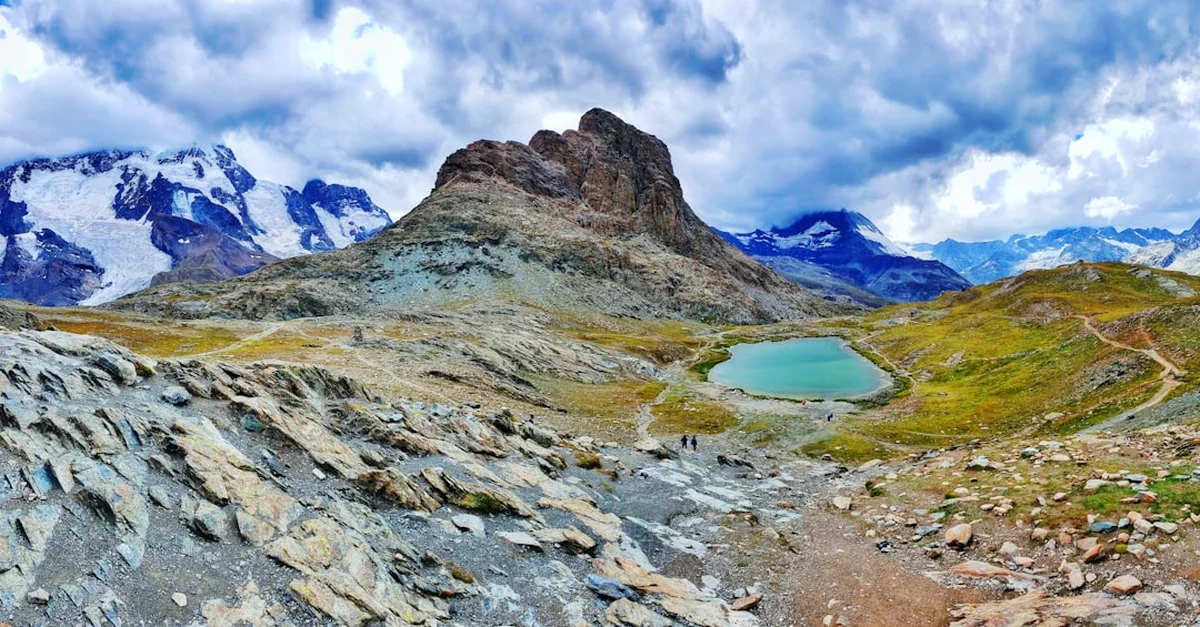
The Gornergrat Trail is a masterclass in alpine geography. While many visitors choose to take the historic Gornergrat Bahn cogwheel railway both up and down, those who choose to walk the route experience a profound transition through Switzerland’s vertical climatic zones. The journey begins in the "nival" zone—a world of perpetual snow and bare rock—and descends through alpine tundra, past crystal-clear glacial lakes, and finally into the fragrant larch and Swiss stone pine forests that shelter the village of Zermatt. The trail is well-marked with the classic yellow and white-red-white Swiss hiking indicators, ensuring that even those new to alpine trekking can navigate with confidence.
The primary draw of the trail is its proximity to the Gorner Glacier, the second-largest glacier system in the Alps. As you descend from the Gornergrat station, the glacier’s massive rivers of ice, punctuated by deep blue crevasses and lateral moraines, feel close enough to touch. The silence of the high mountains is occasionally broken by the distant rumble of shifting ice or the whistle of a marmot. The Matterhorn (4,478 m) remains a constant companion, its jagged, four-sided pyramid shifting in perspective as you move lower into the valley. On a clear day, the reflection of this "Mountain of Mountains" in the still waters of the Riffelsee is a sight that has defined Swiss tourism for over a century.
Physically, the trail is classified as moderate. While the path is generally wide and stable, the sheer amount of descent (nearly 1,500 metres if walking all the way to Zermatt) requires sturdy footwear and, ideally, trekking poles to protect the joints. The air at 3,000 metres is noticeably thinner, and hikers should be prepared for the physiological effects of altitude, even when walking downhill. The beauty of this trail lies in its flexibility; because the railway runs parallel to the path with multiple intermediate stations (Rotenboden, Riffelberg, Riffelalp), hikers can choose to walk only the most scenic sections and hop back on the train whenever they wish.
History and Cultural Context
The history of the Gornergrat Trail is inextricably linked to the golden age of mountaineering and the birth of Swiss alpine tourism. Before the late 19th century, the Gornergrat was the domain of local shepherds and the earliest mountain explorers. The landscape changed forever in 1898 with the opening of the Gornergrat Bahn. This was a feat of extraordinary engineering: the world’s first fully electric cogwheel railway. It allowed tourists to reach the high-altitude ridge without the arduous multi-day trek previously required, transforming Zermatt from a remote farming hamlet into a world-class destination.
The trail itself follows routes that have been used for generations. The lower sections around Riffelalp and Riffelberg were historically used for "Alpabzug"—the seasonal movement of cattle to high summer pastures. You will still see traditional stone-walled huts (gadmer) and small chapels along the route, such as the Brother Klaus Chapel at Riffelberg, which serves as a reminder of the deep spiritual connection the local Valaisan people have with their mountains. The region is also a cornerstone of mountaineering history; the Gornergrat provides the best vantage point to see the routes taken by Edward Whymper and his ill-fated party during the first ascent of the Matterhorn in 1865.
Today, the area is part of a carefully managed protected zone. The Zermatt authorities and the Burgergemeinde (civic community) work tirelessly to balance the high volume of international tourism with the preservation of the fragile alpine ecosystem. Walking the trail today is not just a physical exercise but a journey through a landscape that has been shaped by both the slow grind of glaciers and the ambitious spirit of Swiss pioneers. The Kulmhotel Gornergrat, located at the trailhead, is the highest hotel in Europe and has hosted scientists, astronomers, and royalty for over a century, further cementing the ridge's status as a pinnacle of Swiss cultural heritage.
Want more background? Read extended notes on history and cultural context → Learn more
Seasonal Highlights and Weather Reality
The Gornergrat Trail is a high-altitude environment where winter can return at any moment, even in the height of summer. The primary hiking season runs from late June to late September. Outside of these months, the upper sections of the trail are typically buried under several metres of snow, transforming the route into a winter wonderland suitable only for snowshoeing or skiing.
Spring (June to early July): This is the season of the "Alpine Spring." As the snow melts, the meadows explode into colour. Hikers can see rare alpine flora such as the deep blue Gentian, the bright yellow Alpine Pasqueflower, and, if they are lucky, the elusive Edelweiss. The waterfalls are at their most powerful during this time as the glaciers begin their seasonal melt. However, the highest sections of the trail near Gornergrat may still have lingering snow patches that require careful navigation.
Summer (July to August): This is the peak season. The weather is generally stable, with warm days and cool nights. This is the best time for the iconic Riffelsee reflection, as the lake is completely ice-free. However, summer also brings the risk of afternoon thunderstorms. In the Alps, these storms can develop rapidly, bringing lightning and sudden temperature drops. Hikers should aim to start early to be off the highest ridges by mid-afternoon.
Autumn (September to October): Many locals consider September the finest month for hiking. The air is crisp and exceptionally clear, providing the sharpest views of the surrounding peaks. The larch forests in the lower sections begin to turn a brilliant golden orange, creating a stunning contrast against the white glaciers and blue sky. By October, the first heavy snowfalls usually arrive, effectively closing the full trail for the season.
Weather Reality: At 3,000 metres, the temperature is typically 10–15 degrees Celsius cooler than in Zermatt village. Wind chill can make it feel significantly colder. It is not uncommon to experience "four seasons in one day," where a sun-drenched morning is followed by a sleet shower or thick fog. Always check the local MeteoSwiss forecast and the live webcams at Gornergrat before departing.
Recommended Itinerary
Gornergrat to Zermatt Descent Itinerary
Early Morning: The Ascent and the Summit
- Start: Zermatt Gornergrat Bahn station (1,605 m)
- Activity: Take the 33-minute cogwheel train journey to Gornergrat Kulm (3,089 m)
- Key Waypoint: Gornergrat Observatory and Viewing Platform
- Spend 30–45 minutes at the summit to acclimatise and take in the 360-degree panorama
- Observe the Monte Rosa (4,634 m), the Liskamm, and the twin peaks of Castor and Pollux
- Look down at the Gorner Glacier, the second largest in the Alps
Morning: Gornergrat to Rotenboden
- Distance: 2.5 km
- Elevation Loss: 274 m
- Time: 1 hour
- The trail begins behind the hotel, descending steeply over rocky, high-alpine terrain
- Follow signs for "Rotenboden" and "Riffelsee"
- This section is barren and dramatic, with the Matterhorn directly in front of you
- Arrive at Rotenboden station, the gateway to the lakes
Midday: Rotenboden to Riffelberg
- Distance: 3 km
- Elevation Loss: 233 m
- Time: 1–1.5 hours
- Key Waypoint: Riffelsee (2,757 m)
- Pause at the Riffelsee for the classic Matterhorn reflection photo (best before the wind picks up)
- Continue past the smaller "Lower Riffelsee" for a quieter experience
- The terrain transitions from rock to alpine meadows; look for marmots in the boulder fields
- Arrive at Riffelberg (2,582 m), a perfect spot for a packed lunch or a meal at the mountain restaurant
Afternoon: Riffelberg to Riffelalp
- Distance: 3.5 km
- Elevation Loss: 360 m
- Time: 1 hour
- The trail enters the "Arvenwald"—ancient Swiss stone pine and larch forests
- The path becomes softer underfoot with pine needles and soil
- Pass through the Riffelbord, where you might see Blacknose sheep grazing
- Arrive at Riffelalp (2,222 m), home to the highest tram in Europe and luxury mountain lodges
Late Afternoon: Riffelalp to Zermatt
- Distance: 2.6 km
- Elevation Loss: 617 m
- Time: 1–1.5 hours
- The final descent is the steepest, winding through dense forest
- Cross the Findelbach river via a sturdy bridge
- The trail emerges at the southern end of Zermatt village near the Forest Fun Park
- Finish: Zermatt Village (1,605 m) for a well-earned celebratory drink
Important Notes:
- The itinerary can be shortened by taking the train from any intermediate station (Rotenboden, Riffelberg, or Riffelalp)
- If hiking in reverse (Zermatt to Gornergrat), add 2–3 hours to the total time and prepare for a strenuous 1,469 m climb
- The trail is well-signposted with yellow diamond markers and "Gornergrat" destination signs
- Always check the last train time if you plan to use the railway for any portion of the trip
Planning and Bookings
Book Your Trip
Everything you need to plan your journey
Accommodation
Find places to stay near Zermatt
Flights
Search flights to Zermatt
Essential Preparation
The most critical aspect of planning the Gornergrat Trail is understanding the logistics of Zermatt. Zermatt is a car-free village. If you are travelling by car, you must park in the large multi-storey car park in the nearby village of Täsch and take the shuttle train (running every 20 minutes) into Zermatt. From the Zermatt train station, the Gornergrat Bahn station is located directly across the street.
Physical preparation is also key. While the trail is a descent, walking downhill for 1,500 metres is taxing on the quadriceps and knees. If you have joint issues, consider walking only from Gornergrat to Riffelberg and taking the train for the remainder. Acclimatisation is another factor; the air at 3,000 metres contains significantly less oxygen. Spend at least one day in Zermatt (1,600 m) before attempting the hike to minimise the risk of altitude headaches or fatigue.
Trail Accommodation
This is a day hike requiring no overnight accommodation on the trail itself. Most hikers base themselves in Zermatt, which offers hundreds of hotels, hostels, and apartments. However, for those seeking a unique alpine experience, there are several high-altitude options along the route:
- 3100 Kulmhotel Gornergrat: Located at the very top of the trail. It is the highest hotel in the Swiss Alps. Booking is essential months in advance. Facilities include a restaurant, observatory, and rooms with mountain views.
- Riffelhaus 1853: Located at Riffelberg. A historic hotel offering a spa and outdoor whirlpool with Matterhorn views.
- Riffelalp Resort 2222m: A luxury five-star resort located in the forest section of the trail.
Note: There are no public campsites or wild camping allowed anywhere on the Gornergrat massif. Swiss law strictly prohibits wild camping in wildlife protection areas and high-alpine zones around Zermatt. Violators face heavy fines.
Required Gear
- Hiking Boots: Sturdy, mid-to-high cut boots with a Vibram-style sole are essential. The upper sections are rocky and can be slippery when wet.
- Trekking Poles: Highly recommended for the long descent to save your knees and provide stability on loose scree.
- Layered Clothing: A moisture-wicking base layer, a fleece or down mid-layer, and a high-quality waterproof/windproof shell. Temperatures at the top can be near freezing even in July.
- Sun Protection: High-factor sunscreen (SPF 50+), UV-rated sunglasses, and a wide-brimmed hat. The UV radiation at 3,000 metres is intense, even on cloudy days.
- Navigation: A physical map (available at the Zermatt tourism office) or an offline GPS app like SwitzerlandMobility.
What to Bring
- Water: At least 2 litres per person. While there are restaurants at the train stations, there are no natural water fountains on the upper trail.
- High-Energy Snacks: Nuts, dried fruit, chocolate, or energy bars to maintain blood sugar levels at altitude.
- First Aid Kit: Include blister plasters (Compeed), antiseptic wipes, and ibuprofen for altitude-related headaches.
- Swiss Francs (CHF) or Credit Card: For the train ticket and any refreshments at mountain huts. Most mountain restaurants accept cards, but small cash is useful.
- Camera/Smartphone: With extra battery capacity, as cold temperatures can drain batteries quickly.
Permits
No specific hiking permits are required to walk the Gornergrat Trail. The mountains are free to access for everyone. However, you will need to budget for the Gornergrat Bahn cogwheel railway, which is the primary means of reaching the trailhead. The railway operates on a "yield management" pricing system, meaning prices can vary based on the season.
Railway Costs (Approximate):
- Standard Return Ticket (Zermatt – Gornergrat): CHF 95–126 depending on the month.
- One-Way Ticket (Zermatt – Gornergrat): Approximately CHF 50–63.
- Discounts: Holders of the Swiss Travel Pass or the Half Fare Card receive a 50% discount on the Gornergrat Bahn. Children under 9 travel for free with a Junior Travelcard.
The Peak2Peak Ticket: If you plan to visit both the Gornergrat and the Matterhorn Glacier Paradise in a single day, this combined ticket offers better value. It allows you to take the railway up to Gornergrat, hike, and then use the cable car system to reach the other side of the valley.
Booking Strategy: During the peak summer months (July and August), the trains can become very crowded. It is advisable to purchase your ticket online in advance or at the station the day before. You do not need to book a specific time slot for the train; tickets are generally valid for the entire day. If you want a seat on the right-hand side of the train (which offers the best Matterhorn views on the way up), arrive at the station at least 20 minutes before departure.
Other Activities in the Area
Zermatt is a hub for alpine adventure, and there is much to do beyond the Gornergrat Trail:
- Matterhorn Glacier Paradise: Take the highest cable car in Europe to 3,883 metres. Visit the Glacier Palace, an ice cavern carved 15 metres below the surface of the glacier, and enjoy the 360-degree viewing platform.
- The Five Lakes Walk (5-Seenweg): A popular, easier hike starting from Blauherd that visits five beautiful alpine lakes, three of which offer Matterhorn reflections.
- Matterhorn Museum - Zermatlantis: Located in the village centre, this underground museum tells the dramatic story of the first ascent of the Matterhorn and the development of Zermatt.
- Gorner Gorge: A 15-minute walk from the village, this spectacular gorge features wooden walkways suspended over turquoise glacial waters and ancient rock formations.
- Paragliding: For the ultimate view, take a tandem paragliding flight from Rothorn or Riffelberg, soaring past the north face of the Matterhorn.
- Zermatt Village Stroll: Explore the "Hinterdorf" (old village) with its 30 traditional sun-blackened larch-wood barns and stores dating back to the 16th century.
Safety and Conditions
While the Gornergrat Trail is well-maintained, the alpine environment demands respect. Safety should be your primary concern when heading into the high mountains.
Altitude Sickness: The trail starts at over 3,000 metres. Symptoms of Acute Mountain Sickness (AMS) include headache, nausea, and dizziness. If you feel unwell, the best cure is to descend immediately. The Gornergrat Bahn makes this easy, as you are never more than an hour's walk from a station. Drink plenty of water and avoid alcohol the night before your hike.
Weather Changes: The weather in the Valais Alps can change in minutes. Fog can roll in rapidly, reducing visibility to a few metres. If visibility drops, stay on the marked trail. The Swiss marking system is excellent; if you haven't seen a marker (yellow or white-red-white) for 5–10 minutes, you may have wandered off-course. Retrace your steps to the last known marker.
Terrain Hazards: The upper section of the trail consists of loose rock and scree. Take care with your footing to avoid ankle sprains. In early summer, snow patches can be icy; walk slowly and use trekking poles for balance. Do not attempt to walk onto the Gorner Glacier itself without a professional mountain guide and proper crevasse rescue equipment; the ice is constantly moving and extremely dangerous.
Emergency Contacts:
- General Emergency: 112
- Air Glaciers (Mountain Rescue): 1415
- Zermatt Tourism Office: +41 (0)27 966 81 00
Side Trips and Points of Interest
The Riffelsee: This is the undisputed highlight of the trail. Located just a 10-minute walk from the Rotenboden station, this small alpine tarn provides the perfect mirror for the Matterhorn. For the best photos, arrive before 9:00 AM when the water is most likely to be still. If the main lake is crowded, follow the path for another 5 minutes to the "Unterer Riffelsee" (Lower Riffelsee), which is often much quieter.
Riffelhorn (2,928 m): For experienced hikers or climbers, the Riffelhorn is a popular side trip. It is a jagged peak located between Rotenboden and the Gorner Glacier. While the standard route involves some light scrambling, the views from the top looking directly down onto the glacier are unparalleled. Note: This is significantly more difficult than the main trail and should only be attempted by those comfortable with heights.
The Gorner Glacier Moraine: Near the Rotenboden section, you can take a short detour toward the edge of the lateral moraine. This provides a staggering perspective on the sheer volume of the ice and the power of glacial erosion. You can see the distinct "medial moraines"—dark stripes of rock debris carried in the middle of the ice flow.
Alpine Wildlife: The Gornergrat area is one of the best places in Switzerland to spot alpine wildlife. Marmots are common in the meadows between Riffelberg and Riffelalp; listen for their high-pitched warning whistles. You may also see the Valais Blacknose sheep, famous for their shaggy white wool and black faces. In the higher, rockier sections, keep an eye out for the Alpine Ibex (Steinbock), which can often be seen perched on seemingly impossible cliffs.
Leave No Trace
The Swiss Alps are a fragile ecosystem under increasing pressure from climate change and high tourism volumes. As a hiker, it is your responsibility to minimise your impact on this pristine environment.
- Pack it in, pack it out: There are no rubbish bins on the trail. Carry all your waste, including organic matter like orange peels or banana skins, back to Zermatt. Organic waste decomposes very slowly at high altitudes and can be harmful to local wildlife.
- Stay on the path: Alpine plants are incredibly slow-growing. A single footstep can destroy a plant that has taken years to establish. Stick to the marked trails to prevent soil erosion and protect the flora.
- Respect the wildlife: Observe marmots and ibex from a distance. Never feed them, as this disrupts their natural foraging habits and can make them dependent on humans.
- No Wild Camping: As mentioned, wild camping is strictly prohibited. Use the established hotels or return to the valley.
- Water Protection: Do not use soaps or detergents in alpine lakes like the Riffelsee. These ecosystems are nutrient-poor, and even small amounts of chemicals can cause significant damage.