Gorges du Verdon Trail - The Grand Canyon of Europe
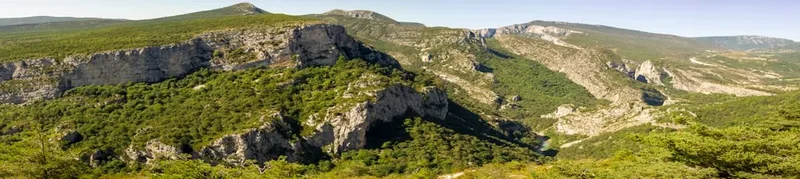
The Gorges du Verdon Trail is a spectacular journey through the heart of Provence, traversing what is widely considered the most beautiful river canyon in Europe. Carved over millennia by the turquoise waters of the Verdon River, the gorge reaches depths of up to 700 metres, creating a dramatic landscape of sheer limestone cliffs, hidden emerald pools, and ancient oak forests. This 90-kilometre multi-day route, often following sections of the GR4 and local trail networks, offers hikers a profound immersion into a vertical world where the scent of wild thyme and lavender mingles with the cool, damp air of the canyon floor. Starting and ending in the historic gateway town of Castellane, the trail challenges the spirit with significant elevation changes and rewards the eyes with vistas that rival the great canyons of the American West. It is a trek that demands physical resilience, careful navigation of technical sections, and a deep appreciation for the raw power of geological time.
- Distance: 90.0 km (loop or point-to-point variations)
- Duration: 4–6 days
- Season: May–June or September–October (avoiding the extreme heat of July and August)
- Accommodation: Gîtes d'étape, mountain refuges, and valley campsites
- Highest point: Signal de l'Ancien (1,999 m) or various ridgeline summits depending on route
- Elevation Gain: Approximately 3,000 m total
- Difficulty: Challenging (requires fitness, sure-footedness, and lack of vertigo)
- Closest City: Castellane (access via Nice)
Overview
The Gorges du Verdon is a geological masterpiece located in the Alpes-de-Haute-Provence region of southeastern France. Often referred to as the "Grand Canyon of Europe," the gorge is approximately 25 kilometres long and up to 700 metres deep. The trail experience is defined by its extreme contrasts: one moment you are standing on a sun-drenched limestone plateau with 360-degree views of the Pre-Alps, and the next you are descending into the humid, shaded depths of the canyon where the river roars through narrow passages like the Styx. The water itself is a startling shade of turquoise-green, a result of glacial flour and fluoride minerals suspended in the flow, creating a visual spectacle against the stark white cliffs.
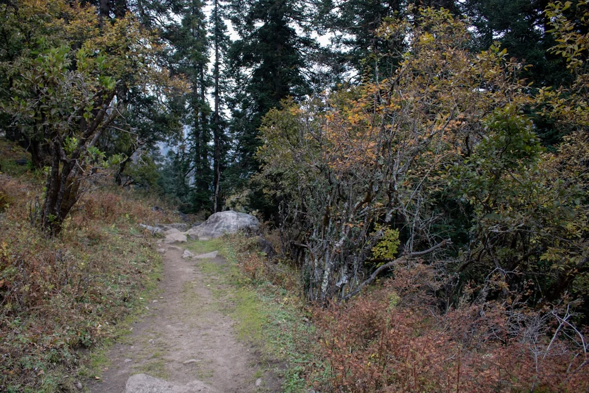
Walking the Gorges du Verdon is not a simple stroll; it is a technical and physical undertaking. The route involves steep descents on loose scree, long climbs through Mediterranean scrubland (maquis), and famous sections like the Sentier Martel, which features dark tunnels and steep metal ladders. The trail requires hikers to be self-sufficient between villages, managing their water carefully in a landscape where the porous limestone swallows surface water, leaving the high ridges bone-dry even when the river is visible hundreds of metres below. The sense of scale here is humbling; the cliffs are so vast that the Griffon vultures circling above—reintroduced to the area in the 1990s—appear as mere specks against the sky despite their nearly three-metre wingspans.
Beyond the physical challenge, the trail offers a cultural journey through the "Haute-Provence" lifestyle. You will pass through medieval villages like Rougon, perched like an eagle's nest above the Point Sublime, and Moustiers-Sainte-Marie, famous for its ceramics and the golden star suspended between two cliffs. The trail provides a unique perspective on how human habitation has adapted to this rugged terrain over centuries, from ancient Roman roads to the modern engineering of the EDF dams that regulate the river's flow. For those seeking a trek that combines world-class geology, technical hiking, and the refined charm of the French countryside, the Gorges du Verdon Trail is an unparalleled destination.
History and Cultural Context
The geological history of the Gorges du Verdon begins in the Triassic period, approximately 250 million years ago, when this part of France was covered by a warm, shallow sea. Over millions of years, layers of limestone and coral built up, eventually being thrust upwards by the collision of the African and European plates that formed the Alps. The Verdon River began its work of erosion during the Quaternary period, cutting through the uplifted limestone layers as the land continued to rise. The result is the dramatic "clue" or canyon structure seen today, where the river has sliced through the rock with surgical precision.
For centuries, the depths of the canyon remained a mystery to the local population. While the plateaus were used for grazing sheep and the villages were built on defensible heights, the canyon floor was considered a dangerous, inaccessible place. It wasn't until 1905 that the first complete exploration of the canyon was undertaken by Édouard-Alfred Martel, the father of modern speleology. Armed with canvas boats and heavy equipment, Martel and his team navigated the treacherous waters and narrow passages, proving that the gorge could be traversed. The most famous hiking path in the canyon, the Sentier Martel, is named in his honour and follows much of the route his expedition mapped. Before Martel, the only people to venture into the depths were "les cueilleurs de buis" (boxwood cutters) who used ropes to descend the cliffs to harvest the hard wood used for making boules and tool handles.
Today, the region is part of the Parc Naturel Régional du Verdon, established in 1997 to protect the unique biodiversity and landscape. The cultural heritage of the area is deeply tied to the "transhumance"—the seasonal movement of livestock—and the production of lavender, honey, and truffles. As you walk, you will see the remnants of this pastoral history in the dry-stone walls and abandoned shepherd huts (cabanes) that dot the landscape. The trail is not just a path through nature; it is a walk through the living history of a resilient Provencal culture that has thrived in the shadow of these great cliffs for generations.
Want more background? Read extended notes on history and cultural context → Learn more
Seasonal Highlights and Weather Reality
Timing is everything when planning a trek in the Gorges du Verdon. The Mediterranean climate brings hot, dry summers and cool, wet winters, but the microclimate within the canyon can create surprising variations. The best windows for hiking are late spring (May to June) and early autumn (September to October).
Spring (May–June): This is arguably the most beautiful time to visit. The wildflowers are in full bloom, including wild orchids and the vibrant yellow broom. The river is usually at its highest flow due to snowmelt from the Alps, making the turquoise colour particularly intense. Temperatures are pleasant for hiking (18°C to 25°C), though evening thunderstorms are common. This is also the best time to see the Griffon vultures during their most active nesting period.
Summer (July–August): Hiking the full trail in mid-summer is generally discouraged for all but the most heat-tolerant individuals. Temperatures on the limestone plateaus can frequently exceed 35°C, and the lack of shade and water sources makes heat exhaustion a significant risk. Furthermore, the area becomes extremely crowded with day tourists, and the "Sentier Martel" can feel like a busy motorway. If you must hike in summer, start at dawn and be finished by midday.
Autumn (September–October): As the summer crowds dissipate, the gorge regains its sense of wilderness. The air becomes crisp and clear, providing the best visibility for the high-altitude viewpoints. The autumn colours of the oak and beech forests provide a stunning contrast to the white limestone. Temperatures are ideal for long days on the trail (15°C to 22°C), though the days are shorter, requiring better pace management.
Winter (November–April): The trail becomes a different beast in winter. While the lower canyon rarely sees heavy snow, the high ridges and plateaus can be covered in ice and snow, making the steep descents and ladders extremely dangerous. Many gîtes and campsites close during this period, and the lack of sun in the deep canyon makes it a cold, damp environment. Winter hiking is only recommended for experienced trekkers with appropriate cold-weather gear and navigation skills.
Recommended Itinerary
5-Day Gorges du Verdon Loop
Day 1: Castellane to Chasteuil
- Distance: 15 km
- Elevation gain: 650 m
- Time: 5–6 hours
- Depart from the historic centre of Castellane, following the GR4 trail
- Steady climb towards the Cadières de Brandis, spectacular rock formations resembling giant chairs
- Traverse the high plateau with views back towards the Verdon valley and the Lac de Castillon
- Descend through oak forests to the tiny, picturesque hamlet of Chasteuil
- Stay in a local gîte or small campsite; this day serves as an excellent warm-up for the steeper terrain ahead
Day 2: Chasteuil to Rougon
- Distance: 17 km
- Elevation gain: 800 m
- Time: 6–7 hours
- Follow the ridgeline trail with constant views of the narrowing gorge
- Pass through the abandoned village of Encastel, a haunting reminder of the region's rural exodus
- Ascend to the Signal de l'Ancien for a 360-degree panorama of the Pre-Alps
- Long descent into the village of Rougon, perched high above the entrance to the Grand Canyon
- Rougon is famous for its "Point Sublime" viewpoint and is the best place to spot vultures at sunset
Day 3: Rougon to La Palud-sur-Verdon (via Sentier Martel)
- Distance: 16 km
- Elevation gain: 700 m (including many short, steep sections)
- Time: 7–8 hours
- Descend from Rougon to the "Point Sublime" and enter the canyon floor
- Follow the legendary Sentier Martel, the most technical and famous section of the trail
- Navigate the Tunnel du Baou (670 m long, pitch black—torch required) and the Tunnel des Trescaïre
- Climb the Brèche Imbert: 252 metal steps on a steep ladder system descending a cliff face
- Walk alongside the roaring river at the "Styx" and "Le Maugué" passages
- Final steep climb out of the canyon to reach the village of La Palud-sur-Verdon, the climbing capital of the region
Day 4: La Palud-sur-Verdon to Chalet de la Maline and Sentier de l'Imbut
- Distance: 14 km
- Elevation gain: 600 m
- Time: 6–7 hours
- Short walk or shuttle to the Chalet de la Maline, a historic refuge perched on the canyon rim
- Descend the steep, zig-zagging path to the riverbed
- Follow the Sentier de l'Imbut, often considered even more beautiful and rugged than the Martel
- Pass the "Passerelle de l'Estellier," a suspension bridge over the turquoise water
- Explore the "Vire d'Etroite," a narrow ledge carved into the cliff (not for those with vertigo)
- Reach the "Imbut" (the funnel), where the Verdon River disappears underground beneath massive boulders
- Return climb to the rim via the "Sentier des Cavaliers" and overnight at a nearby gîte
Day 5: Chalet de la Maline to Moustiers-Sainte-Marie
- Distance: 18 km
- Elevation gain: 450 m
- Time: 6–7 hours
- Follow the GR4 along the Roman road and high plateaus overlooking the Lac de Sainte-Croix
- Traverse fields of wild lavender and thyme with the scent of Provence in the air
- Gradual descent with the turquoise expanse of the lake growing larger in the distance
- Arrive in Moustiers-Sainte-Marie, one of the "Most Beautiful Villages of France"
- Celebrate the finish beneath the famous star of Moustiers and explore the narrow, waterfall-lined streets
- Optional: Take a bus or pre-arranged shuttle back to Castellane to complete the loop
Important Notes:
- The Sentier Martel and Sentier de l'Imbut are linear; logistics for shuttles or return loops must be planned
- Water is scarce on the plateaus; carry at least 3 litres per person
- The tunnels on Day 3 are mandatory and require a reliable headlamp
- Check the EDF (Électricité de France) water release schedule; the river level can rise rapidly if the dams are opened
- The Brèche Imbert ladders are one-way (descending) in peak season to manage traffic
Planning and Bookings
Book Your Trip
Everything you need to plan your journey
Accommodation
Find places to stay near Castellane
Flights
Search flights to Castellane
Essential Preparation
The Gorges du Verdon Trail requires a higher level of logistical planning than many other European treks due to the scarcity of water and the specific nature of the terrain. Fitness is paramount; while the total elevation gain of 3,000 metres over five days may seem manageable, the "Verdon Metre" is notoriously difficult. Trails are often composed of loose limestone scree, steep steps, and technical ledges that require constant focus and engage different muscle groups than flat walking. Hikers should be comfortable with heights and basic scrambling.
Logistically, Castellane is your primary hub. It is well-connected to Nice via the "Bus de la Pagne" or regional coaches. If you are driving, Castellane has several long-term parking options. It is highly recommended to spend a night in Castellane before starting to finalise gear and check local weather reports at the Maison du Parc. Booking accommodation in advance is essential, especially during the shoulder seasons of May, June, and September, as the limited gîtes d'étape fill up months in advance with organised trekking groups.
Trail Accommodation
Accommodation along the Gorges du Verdon Trail is a mix of traditional mountain refuges, village gîtes d'étape, and valley campsites. There is no "wild camping" allowed within the National Park boundaries, and this rule is strictly enforced to prevent forest fires and protect the environment.
Gîtes d'Étape and Refuges: These are the most popular options. They typically offer dormitory-style sleeping (4–12 people per room) and "demi-pension" (half-board), which includes a multi-course Provencal dinner and breakfast. Notable stops include the Chalet de la Maline (run by the CAF - Club Alpin Français) and various gîtes in Rougon and La Palud. Expect to pay between €50 and €70 for half-board. Facilities usually include hot showers (sometimes metered), drying areas, and common rooms. Electricity is available for charging devices, but WiFi is often non-existent or very weak.
Campsites: For those carrying their own gear, there are excellent campsites in Castellane, Chasteuil, and La Palud. These range from basic municipal sites to "four-star" establishments with swimming pools. Camping costs roughly €15–€25 per night for a tent and two people. Note that many campsites are located in the valley, which may require a detour from the high-level ridgeline trails.
Booking: Most gîtes can be booked via email or phone. During the peak of the shoulder season, you should aim to book at least 3–4 months in advance. If a gîte is full, La Palud-sur-Verdon has several small hotels and chambres d'hôtes (B&Bs) as alternatives.
Required Gear
- Hiking Boots: Sturdy, high-cut boots with a stiff sole (Vibram or similar) are essential. The limestone rock is sharp and the scree slopes are unstable; ankle support is non-negotiable.
- Headlamp: A high-quality headlamp with at least 200 lumens is mandatory for the tunnels on the Sentier Martel. Bring spare batteries or a power bank.
- Backpack: A 35–50L pack with a good suspension system and rain cover.
- Navigation: IGN Map 3442OT (Gorges du Verdon) is the gold standard. A GPS or offline map app (like Gaia or AllTrails) is helpful, but don't rely solely on electronics as the deep canyon can interfere with satellite signals.
- Clothing: Moisture-wicking base layers, a lightweight fleece or down jacket for cool evenings, and a high-quality waterproof shell. Even in Provence, mountain storms can be violent.
- Sun Protection: High-factor sunscreen, a wide-brimmed hat, and UV-rated sunglasses. The white limestone reflects an immense amount of glare.
- First Aid: Blister kits (Compeed), antiseptic wipes, rehydration salts, and any personal medications.
What to Bring
- Water Capacity: You must be able to carry at least 3 litres of water. Many sections of the trail have zero water sources for 6–7 hours. A combination of a 2L bladder and a 1L hard bottle is recommended.
- Water Treatment: While you should fill up at gîtes, a lightweight filter (like a Sawyer Squeeze) or purification tablets are useful for emergencies, though river water should be a last resort due to upstream agricultural runoff.
- Food/Snacks: High-energy snacks (nuts, dried fruit, saucisson, local cheese). While you can buy lunch supplies in Castellane and La Palud, there are no shops between these points.
- Trekking Poles: Highly recommended for the steep descents and to save your knees on the Brèche Imbert and other ladder sections.
- Cash: Many small gîtes and village cafés do not accept credit cards. Carry at least €200–€300 in cash for the duration of the trek.
- Lightweight Towel: For use in gîtes and the occasional (very cold) dip in the river.
- Earplugs: Essential for sleeping in crowded dormitories.
Permits
Currently, there is no formal "permit" required to hike the Gorges du Verdon Trail for individuals or small groups. However, the area is strictly regulated by the Parc Naturel Régional du Verdon, and hikers must adhere to specific rules to ensure the trail remains open and the environment protected.
Key Regulations:
- No Wild Camping: Bivouacking or wild camping is strictly prohibited throughout the canyon and on the surrounding plateaus. This is primarily a fire prevention measure, as the region is highly susceptible to forest fires in summer. You must stay in designated campsites or gîtes.
- Fire Ban: Open fires are strictly forbidden at all times. Even the use of camping stoves may be restricted during periods of extreme fire risk (check local "Préfecture" notices).
- Group Size: Organised groups of more than 10 people may need to register with the Park authorities.
- River Access: Certain parts of the river are protected zones where swimming or launching watercraft is prohibited to protect the nesting sites of rare birds and fish species.
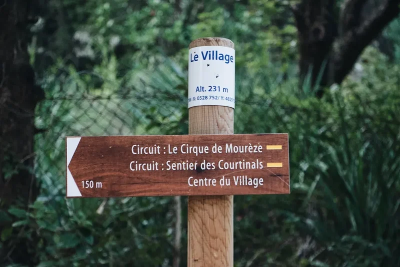
Shuttle Services: While not a permit, the "Navette des Gorges" (Gorge Shuttle) is a vital part of the logistics. During the summer and shoulder seasons, this bus connects the Point Sublime, La Palud, and the Chalet de la Maline. Using this service helps reduce traffic on the narrow "Route des Crêtes" and is often the only way to return to your starting point if you are doing day-hike sections of the main trail. Tickets can be purchased on the bus or at the tourist office in La Palud.
Other Activities in the Area
The Verdon region is a world-class destination for outdoor enthusiasts. If you have extra days, consider these activities:
- Rock Climbing: La Palud-sur-Verdon is legendary in the climbing world. With over 1,500 routes on immaculate limestone, it offers everything from beginner slabs to multi-pitch "big wall" routes on the Escalès cliff. Local guides are available for all levels.
- Canyoning and Aquatic Trekking: Explore the side canyons or the main river in a way that hiking doesn't allow. Aquatic trekking involves floating down the rapids in a thick wetsuit and helmet—a thrilling way to see the "Styx" from water level.
- Kayaking and Pedaloes: At the western end of the gorge, where the river enters the Lac de Sainte-Croix, you can rent kayaks or electric boats to explore the first few kilometres of the canyon from the water. This is a much more relaxed way to experience the scale of the cliffs.
- The Route des Crêtes: For those with a car (or very strong cycling legs), this 23-kilometre loop road from La Palud offers 14 spectacular viewpoints (belvédères) looking directly down into the canyon. It is the best way to see the sheer verticality of the Escalès cliffs.
- Moustiers-Sainte-Marie Exploration: Spend a full day in this village. Hike up to the Notre-Dame de Beauvoir chapel, visit the Faïence (ceramics) Museum, and enjoy the local gastronomy, including honey-glazed lamb and lavender ice cream.
Safety and Conditions
The Verdon River and EDF Dams: This is the most critical safety factor. The flow of the Verdon is regulated by several upstream dams managed by EDF. On "release days" (usually Tuesdays and Fridays in summer, but variable), the water level can rise significantly and the current becomes very powerful. While this is great for rafters, it can make certain river-level trail sections dangerous. Always check the flow schedule at the Maison du Parc or local tourist offices before heading into the canyon floor.
Heat and Hydration: The combination of Mediterranean sun and white limestone creates an oven-like effect. Heatstroke is a genuine risk. Hikers have died in the Verdon due to dehydration. You must carry more water than you think you need and use electrolytes. Avoid hiking during the hottest part of the day (12:00–16:00) if the temperature exceeds 30°C.
Vertigo and Technical Sections: The Sentier Martel and Sentier de l'Imbut feature sections with significant exposure. The Brèche Imbert ladders are steep and can be intimidating for those with a fear of heights. Some ledges are narrow with 100-metre drops directly to the river. If you suffer from severe vertigo, these sections may not be suitable for you. Always maintain three points of contact on ladders and use the handrails provided.
Flash Floods and Storms: Provencal thunderstorms are notoriously sudden and violent. If a storm is forecast, avoid the canyon floor and the high, exposed ridges. Lightning is a major hazard on the plateaus, and heavy rain can turn dry gullies into torrents within minutes, making river crossings impossible.
Tunnels: The tunnels on the Sentier Martel are not just dark; they are often wet and slippery with uneven floors. A headlamp is essential—using a phone torch is insufficient and dangerous as it leaves you with only one hand free for balance. Watch your head, as the ceiling height varies.
Emergency Contacts: The European emergency number is 112. Be aware that mobile signal is non-existent in much of the canyon. You may need to climb to a ridgeline or return to a village to make a call. Carrying a whistle and a small signal mirror is a wise precaution.
Side Trips and Points of Interest
The Styx: Named after the river in Greek mythology that formed the boundary between Earth and the Underworld, this is a section where the Verdon narrows significantly between two sheer walls. The water here is deep, swirling, and a haunting shade of green. It is one of the most atmospheric spots in the entire canyon and a highlight of the Sentier Martel.
The Tunnels (Baou and Trescaïre): These tunnels were originally carved in the early 20th century as part of a failed hydroelectric project. Walking through the 670-metre Tunnel du Baou is a surreal experience; halfway through, there are "windows" cut into the rock offering framed views of the river far below. The darkness and the sound of dripping water create a unique subterranean interlude to the hike.
Point Sublime: Located near the village of Rougon, this is perhaps the most famous viewpoint in the region. It marks the spot where the Verdon River enters the narrowest part of the canyon. From here, you can see the "Samson's Pillar," a massive limestone monolith that guards the entrance to the gorge. It is also the primary release point for the Griffon vultures, which can often be seen catching thermals just metres from the observation deck.
The Imbut and the Baou Beni: At the end of the Sentier de l'Imbut, the river disappears into a chaotic jumble of massive white boulders. Beyond this lies the "Baou Beni" (the Blessed Cliff), a hidden sanctuary of emerald water and mossy rocks that feels like a lost world. It is a place of profound silence and beauty, accessible only to those who complete the challenging Imbut trail.
Cadières de Brandis: These "chairs" are massive dolomitic limestone pillars that dominate the skyline above Castellane. A side trip to their base offers some of the best geological photography in the Pre-Alps and a chance to see the transition from alpine to Mediterranean flora.
Leave No Trace
The Gorges du Verdon is a fragile ecosystem under immense pressure from tourism. As a hiker, you are a guest in a protected natural space that is home to rare species like the Lanza's alpine salamander and the Egyptian vulture. Following Leave No Trace principles is not just a suggestion; it is a requirement for the continued preservation of this landscape.
Your responsibility as a walker:
- Pack it in, pack it out: This includes all organic waste like orange peels and apple cores, which decompose very slowly in the arid Mediterranean climate and can harm local wildlife.
- Respect the silence: The canyon walls act as a natural amphitheatre. Loud voices or music can disturb nesting birds and ruin the experience for other hikers.
- Stay on the path: Erosion is a major issue on the steep limestone slopes. Cutting switchbacks destroys vegetation and leads to trail failure.
- Water protection: Do not use soaps or detergents in the river or side streams. Even "biodegradable" soaps can be toxic to aquatic life in small pools.
- Human waste: Use the toilets in villages and gîtes. If you must go on the trail, use a "cat hole" at least 60 metres from any water source and pack out your toilet paper.
- Flora and Fauna: Do not pick wildflowers or disturb the rocks. Many of the plants in the Verdon are endemic and found nowhere else on Earth.
By walking with respect, you ensure that the "Grand Canyon of Europe" remains a wild and spectacular place for the next generation of explorers.