Giants Cup Trail - A Journey Through the Dragon’s Foothills
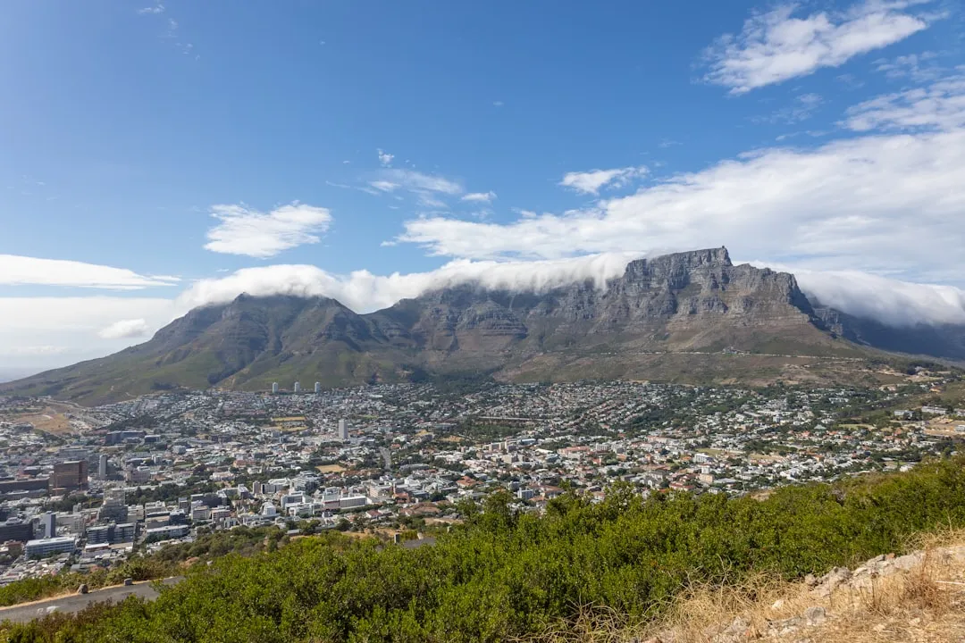
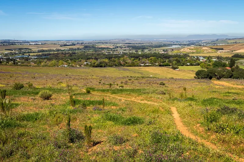
The Giants Cup Trail is South Africa’s premier mountain hiking experience, traversing 68 kilometres of the spectacular Maloti-Drakensberg Park, a UNESCO World Heritage Site. Located in the southern reaches of the KwaZulu-Natal Drakensberg, this four-day trek winds through the "Little Berg"—the lower sandstone plateau that sits beneath the towering basalt ramparts of the main escarpment. Unlike the high-altitude traverses that require extreme mountaineering skills, the Giants Cup Trail offers a more accessible but no less dramatic immersion into one of the world’s most ancient and biologically diverse mountain ranges. The route runs from the base of the legendary Sani Pass in the north to the remote Bushman’s Nek valley in the south, providing hikers with a continuous, well-marked path through rolling grasslands, crystalline mountain streams, and hidden valleys filled with protea savannah.
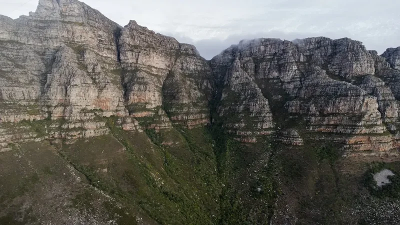
Walking the Giants Cup is an exercise in scale and perspective. To your west, the Great Escarpment rises like a jagged wall of dark basalt, often capped with snow in winter or shrouded in dramatic thunderclouds in summer. To your east, the landscape tumbles away into the green, undulating hills of the KwaZulu-Natal Midlands. This is a landscape defined by its geology—the golden Clarens Sandstone formations have been carved by wind and water into fantastic shapes, creating caves that once sheltered the San people, the original inhabitants of these mountains. Today, the trail serves as a sanctuary for rare wildlife, including the endangered Bearded Vulture (Lammergeier) and the majestic Eland, Africa’s largest antelope. For those seeking a multi-day wilderness experience that balances physical challenge with profound natural beauty, the Giants Cup Trail remains the definitive South African mountain walk.
- Distance: 68.0 km one-way
- Duration: 4 days
- Season: Year-round (Best: April–May and September–October)
- Accommodation: Five overnight huts (Pholela, Mzimkhulwana, Winterhoek, Swiman, Bushman's Nek)
- Highest point: Approximately 1,950 metres
- Difficulty: Moderate (requires good fitness but no technical climbing)
- Direction: North to South (Sani Pass to Bushman's Nek)
Overview
The Giants Cup Trail is often described as the "gentle giant" of the Drakensberg. While the "High Berg" is famous for its brutal climbs and thin air, the Giants Cup stays predominantly between 1,600 and 2,000 metres above sea level. This elevation provides a perfect "Goldilocks" zone for hiking: high enough to offer crisp alpine air and expansive vistas, but low enough to avoid the debilitating effects of extreme altitude and the most severe mountain weather. The trail is meticulously designed to showcase the diversity of the southern Drakensberg, moving through distinct ecological zones that change with every ridge crossed. One moment you are walking through a forest of ancient Yellowwood trees in a sheltered kloof, and the next you are emerging onto a windswept ridge covered in hardy alpine fynbos and ericas.
The name "Giants Cup" refers to the distinctive shape of the valley between the peaks of the southern Berg, which resembles a massive chalice when viewed from certain angles. Throughout the 68-kilometre journey, the trail crosses numerous river systems, including the Pholela, Mzimkhulwana, and Mzimkulu rivers. These waters are legendary for their clarity and purity, often forming deep, emerald-green pools that provide the ultimate reward for a hot day’s hiking. The trail is not a loop; it is a linear journey that creates a genuine sense of progression. Each day feels like a new chapter in a story, moving from the bustling gateway of Sani Pass into increasingly remote and silent wilderness areas where the only sounds are the wind in the grass and the occasional cry of a Jackal Buzzard.
Physically, the trail is classified as moderate. While the total elevation gain is 1,600 metres, it is spread across the four days, meaning there are few "soul-crushing" ascents. However, the terrain is rugged. Hikers must contend with rocky paths, slippery river crossings, and the famous Drakensberg "ups and downs" that can test even seasoned legs. The trail is well-marked with yellow painted footprints on rocks, but a basic ability to read a map and navigate in misty conditions is essential. This is a wilderness area where weather can change in minutes, transforming a sunny afternoon into a freezing, misty landscape where visibility drops to a few metres. It is this unpredictability that gives the Giants Cup its edge—it is a managed trail, but it never feels tamed.
History and Cultural Context
The history of the Giants Cup Trail is inextricably linked to the San people (Bushmen), who inhabited these mountains for thousands of years. The Drakensberg, or "uKhahlamba" (Barrier of Spears) in isiZulu, contains one of the highest concentrations of rock art in the world. As you walk the trail, you are passing through a landscape that was once a rich hunting ground. The sandstone overhangs and caves along the route served as both homes and spiritual cathedrals for the San. Their paintings, created using ochre, blood, and plant juices, depict eland, hunters, and complex shamanic rituals. While the trail itself does not enter the most sensitive archaeological sites to protect them, several caves near the route contain visible art that serves as a haunting reminder of a culture that was eventually displaced by the arrival of pastoralists and colonial settlers.
In the 19th century, the southern Drakensberg became a frontier zone. European settlers moved into the Underberg and Himeville areas, establishing sheep and cattle farms. This led to inevitable conflict with the San, who viewed the settlers' livestock as fair game in a landscape where their traditional prey was being depleted. The "Bushman’s Nek" pass, where the trail concludes, was a primary route for San raiding parties returning to the mountains. Later, the area became significant during the Anglo-Zulu and Anglo-Boer wars, with the rugged terrain providing a natural fortress. The Sani Pass, the trail's starting point, began as a simple bridle path used by traders on donkeys to move goods between the Colony of Natal and the mountain kingdom of Basutoland (now Lesotho).
The Giants Cup Trail as a formal hiking route was established in the late 1970s by the Natal Parks Board (now Ezemvelo KZN Wildlife). It was designed to provide a world-class multi-day experience that would encourage conservation through sustainable tourism. By creating a designated path with overnight huts, the authorities were able to manage the human impact on this fragile ecosystem while allowing people to experience its majesty. In 2000, the area was designated as part of the Maloti-Drakensberg Transfrontier Conservation Area, recognising its global importance for biodiversity and cultural heritage. Today, walking the trail is not just a physical exercise; it is a walk through time, where the geological, archaeological, and colonial histories of South Africa converge.
Want more background? Read extended notes on history and cultural context → Learn more
Seasonal Highlights and Weather Reality
The Drakensberg is a land of climatic extremes, and choosing the right season is critical for a successful Giants Cup experience. The most popular times are the shoulder seasons: autumn (April to May) and spring (September to October). During autumn, the summer rains have ceased, the air is exceptionally clear, and the grasslands turn a beautiful golden hue. The temperatures are mild during the day and crisp at night, making for perfect hiking conditions. Spring brings a different magic; the mountains erupt in wildflowers, and the first summer rains turn the landscape a vibrant, electric green. However, spring can also bring "Berg Winds"—hot, dry gusts from the interior that increase fire risk and can make hiking strenuous.
Summer (November to March) is the season of the Great African Thunderstorm. While the landscape is at its most lush and the waterfalls are in full flow, hikers must be prepared for rain almost every afternoon. These storms are spectacular but dangerous; they bring intense lightning and can cause rivers to rise rapidly. It is essential to start your day early in summer to reach the safety of the hut before the mid-afternoon deluge. Temperatures can reach 30°C, and the humidity in the valleys can be high. Conversely, winter (June to August) is the season of fire and ice. The days are often cloudless and warm, but temperatures plummet below freezing as soon as the sun sets. Snow is common on the high peaks and occasionally falls on the trail itself. Winter hikers must be prepared for sub-zero nights and the possibility of being snowed in, though the lack of rain makes for very stable walking conditions.
Regardless of the season, the "Drakensberg Mist" is a constant factor. A clear morning can be swallowed by a thick, wet fog in less than thirty minutes. This mist can disorientate hikers and makes the trail markers difficult to see. Navigation skills and a good waterproof jacket are non-negotiable year-round. The weather here is not something to be fought; it is something to be respected and planned for. Always check the local forecast at the Ezemvelo KZN Wildlife offices before setting out, and be prepared to wait out a storm if necessary.
Recommended Itinerary
4-Day Giants Cup Trail Itinerary
Day 1: Sani Pass to Pholela Hut
- Distance: 13.3 km
- Elevation gain: 420 m
- Time: 4–5 hours
- Start at the Sani Pass Hotel trailhead (ensure permits are signed)
- The trail begins with a steady climb onto the sandstone plateau
- Pass through Protea savannah with views of the Sani Pass road winding into Lesotho
- Cross the Gididi River (usually a simple rock hop)
- Arrive at Pholela Hut, situated near the Pholela River
- The hut is located in a beautiful valley with excellent swimming holes nearby
- This is a relatively gentle introduction to the trail, allowing hikers to find their rhythm
Day 2: Pholela Hut to Mzimkhulwana Hut
- Distance: 15.1 km
- Elevation gain: 580 m
- Time: 5–6 hours
- Climb out of the Pholela valley towards the "Tortoise Rocks" formations
- Cross the ridge into the Mzimkhulwana valley
- Pass through sections of indigenous forest in the sheltered kloofs
- The trail follows the contour of the mountain, offering constant views of the main escarpment
- Arrive at Mzimkhulwana Hut, which overlooks a large dam and the river
- This section is famous for its birdlife; keep an eye out for the Ground Woodpecker and various sunbirds
- The descent into the valley is steep and can be slippery after rain
Day 3: Mzimkhulwana Hut to Winterhoek Hut
- Distance: 16.6 km
- Elevation gain: 450 m
- Time: 6–7 hours
- A day of river crossings and rolling grasslands
- The trail crosses the Mzimkhulwana River and climbs towards the "Garden Castle" area
- Pass through the "Black Lake" area, a unique high-altitude wetland
- Spectacular views of the Rhino Peak (3,051 m) towering above the trail
- Arrive at Winterhoek Hut, a remote and quiet location
- This is often considered the most scenic day of the trail due to the proximity of the high peaks
- The path can be overgrown in summer, so long trousers or gaiters are recommended
Day 4: Winterhoek Hut to Bushman’s Nek
- Distance: 23.0 km
- Elevation gain: 150 m (mostly descent)
- Time: 7–9 hours
- The longest day of the trail, requiring an early start
- The trail passes through the Swiman area and heads south towards the Lesotho border
- Cross the Mzimkulu River, the largest river on the route (can be challenging in high flow)
- Final stretch through the wide, grassy plains of the Bushman’s Nek valley
- Finish at the Bushman’s Nek office to sign out
- Arrange transport back to Underberg or Sani Pass from this point
- Though long, the terrain is flatter than previous days, allowing for a good pace
Important Notes:
- The itinerary can be extended to 5 days by staying at Swiman Hut between Winterhoek and Bushman's Nek
- Water is generally available from streams, but treatment is advised near agricultural areas
- The trail is one-way; shuttle services are available in Underberg to return you to your vehicle
- Always sign the mountain register at each hut for safety tracking
- Cell phone reception is intermittent and should not be relied upon for emergencies
Planning and Bookings
Book Your Trip
Everything you need to plan your journey
Accommodation
Find places to stay near Underberg
Flights
Search flights to Underberg
Essential Preparation
The Giants Cup Trail requires careful logistical planning, primarily because it is a linear route. Most hikers base themselves in the town of Underberg or Himeville the night before starting. These towns offer full amenities, including supermarkets, outdoor stores, and pharmacies. You will need to arrange a shuttle or a two-car drop-off system: leave one vehicle at the Bushman’s Nek finish point and drive the other to the Sani Pass Hotel start point. Several local operators in Underberg provide reliable hiker shuttle services for a fee.
Fitness is a key requirement. While not a technical climb, carrying a 15–20 kg pack over 15+ kilometres of mountain terrain for four consecutive days is physically demanding. Ensure you have completed several day hikes with a weighted pack in the weeks leading up to the trip. Additionally, familiarise yourself with basic first aid, particularly for blisters, sprains, and dehydration. The Drakensberg is remote, and help can be several hours away.
Trail Accommodation
Accommodation on the Giants Cup Trail consists of five designated overnight huts managed by Ezemvelo KZN Wildlife. These are: Pholela, Mzimkhulwana, Winterhoek, Swiman, and Bushman's Nek. During the standard 4-day itinerary, you will typically use three of these.
Hut Facilities:
- Basic bunk beds with thin mattresses (sleeping bags and pillows required)
- Enclosed communal kitchen/living area
- Outdoor braai (barbecue) pits (wood is not provided; hikers must use gas stoves for cooking)
- Cold water showers and flush toilets (water is piped from mountain streams)
- No electricity or charging points
- Basic solar lighting is present in some huts but often unreliable; bring a head torch
What Huts Don't Provide:
- Bedding, blankets, or pillows
- Cooking utensils, pots, or cutlery
- Food or snacks
- Toilet paper or toiletries
- Heating (huts can be extremely cold in winter)
Booking Requirements:
- Bookings must be made through the Ezemvelo KZN Wildlife central reservations office or their online portal
- It is advisable to book at least 3–6 months in advance, especially for peak periods (April, May, September, October)
- Cost is approximately R150–R250 per person per night (subject to annual increases)
- A wilderness permit is included in your hut booking
Required Gear
- Hiking boots: High-cut with good ankle support and waterproof lining (essential for river crossings and mud)
- Backpack: 50–70 litre capacity with a waterproof rain cover
- Waterproof jacket: High-quality breathable hardshell (Gore-Tex or similar) to withstand heavy storms
- Sleeping bag: 3-season (comfort rating 0°C) for most of the year; 4-season (-5°C or lower) for winter
- Navigation: Topographic map (1:50,000 scale) and a compass or GPS device
- Head torch: With spare batteries (essential for hut life and emergency night movement)
- First aid kit: Including blister pads, antiseptic, rehydration salts, and any personal medication
- Gaiters: Highly recommended to protect against ticks, snakes, and wet grass
What to Bring
- Food: Lightweight, high-calorie dehydrated meals, nuts, dried fruit, and energy bars (no food available on trail)
- Cooking system: Lightweight gas stove and sufficient fuel canisters (meths/spirit stoves are less effective at altitude)
- Water treatment: Purification tablets or a lightweight filter (while mountain water is generally clean, runoff from Lesotho can contaminate some streams)
- Clothing: Moisture-wicking base layers (merino wool is best), a fleece or down mid-layer, and lightweight hiking trousers (avoid denim)
- Sun protection: SPF 50+ sunscreen, lip balm, wide-brimmed hat, and polarised sunglasses
- Personal items: Biodegradable soap, small towel, toothbrush, and a trowel for LNT toileting if caught between huts
- Emergency gear: A whistle, a space blanket, and a multi-tool
Permits
Access to the Giants Cup Trail is strictly controlled to prevent overcrowding and protect the environment. A permit is mandatory for every hiker. When you book your overnight huts through Ezemvelo KZN Wildlife, your permit is automatically generated as part of your reservation. You must carry a printed copy of your booking confirmation at all times, as rangers do perform spot checks on the trail.
Permit Procedures:
- Mountain Register: This is the most critical safety step. Before starting at Sani Pass, you must sign the mountain register. You must also sign the register at every hut you stay in and finally sign out at the Bushman’s Nek office. This allows rescue teams to narrow down your location in the event of an emergency.
- Group Size: The maximum group size is generally 12 people to minimise impact on the huts and the trail. Solo hiking is permitted but strongly discouraged due to the remote nature of the terrain and weather risks.
- Day Permits: If you only intend to walk a small section of the trail as a day hike, you can purchase a day permit at the Sani Pass Hotel office or the Cobham Nature Reserve office.
Costs and Fees:
- Hut fees (which include the permit) are paid at the time of booking.
- Community Levies: A small daily conservation levy is often added to the booking fee to support local community projects and park maintenance.
- International Visitors: There is currently no tiered pricing for international vs. local hikers, making the Giants Cup exceptionally good value for foreign travellers.
Other Activities in the Area
The Southern Drakensberg is a hub for outdoor enthusiasts. Consider adding these experiences to your itinerary:
- Sani Pass 4x4 Tour: If you have an extra day, take a guided 4x4 tour up the Sani Pass into Lesotho. You’ll visit the "Highest Pub in Africa" (2,874 m) and experience the dramatic change in culture and landscape on the Lesotho plateau.
- Fly Fishing: The Underberg area is world-renowned for trout fishing. Many local lodges offer day passes for the pristine rivers and dams in the foothills.
- Rock Art Tours: Visit the Main Caves at Giant’s Castle (a short drive away) for a guided tour of some of the best-preserved San rock art in the country.
- Horse Trekking: Several operators in the Bushman’s Nek and Underberg areas offer horse rides ranging from one hour to multi-day expeditions into the mountains.
- Mountain Biking: The Underberg region hosts several major MTB races. There are numerous dedicated trails for all skill levels in the pine plantations and foothills.
Safety and Conditions
Weather Hazards: The greatest danger on the Giants Cup Trail is the weather. Hypothermia is a genuine risk, even in summer, if you are caught in a storm without proper waterproof gear. Lightning is a major threat during summer afternoons; if a storm approaches, move off high ridges, avoid standing near lone trees or water, and crouch low to the ground. In winter, the risk shifts to extreme cold and snow. Always check the "Berg Forecast" before setting out.
River Crossings: The trail crosses several significant rivers. After heavy rain, these can become impassable torrents. Never attempt to cross a river if the water is above knee-height or moving too fast. It is better to wait a few hours for the level to drop (Drakensberg rivers rise and fall quickly) or to turn back to the previous hut.
Wildlife and Pests:
- Snakes: The Puff Adder and Berg Adder are present. They are well-camouflaged and slow to move. Watch where you step, especially in long grass or rocky outcrops.
- Ticks: Tick-bite fever is a possibility. Wear gaiters and check your body for ticks every evening at the hut.
- Baboons: While generally shy, baboons can become aggressive if they associate humans with food. Never feed them and keep your food securely packed inside the huts.
Emergency Protocol: In the event of a serious injury, one person should stay with the patient while another (or two) heads to the nearest hut or trailhead to raise the alarm. Carry a whistle (6 blasts for distress) and a mirror for signalling. Mountain Rescue South Africa (MSAR) operates in the area, but evacuations are often conducted by helicopter and are highly dependent on weather conditions. Ensure your travel insurance covers mountain rescue.
Side Trips and Points of Interest
The Tortoise Rocks: Located on Day 2, these massive sandstone boulders have been weathered into shapes that remarkably resemble giant tortoises. They provide an excellent spot for a mid-morning break and offer panoramic views of the Pholela valley. The area around the rocks is also a great place to look for the Cape Rockjumper, a bird endemic to the high-altitude rocky slopes of South Africa.
Mzimkhulwana Dam: Situated right next to the Mzimkhulwana Hut, this dam is a haven for waterfowl. In the early morning, the water is often perfectly still, reflecting the peaks of the Garden Castle. It’s a peaceful spot for photography or birdwatching. The dam is also home to otters, which can occasionally be seen swimming near the reed beds at dusk.
Rhino Peak: While the Giants Cup Trail doesn't summit Rhino Peak, the mountain dominates the skyline on Day 3. For very fit hikers with an extra day, a side trip from the Winterhoek area up the Mashai Pass to the summit of Rhino Peak (3,051 m) offers one of the best views in the entire Drakensberg range. This is a strenuous 8–10 hour return trip and should only be attempted in clear weather.
Langalibalele Pass: Near the start of the trail, this pass has significant historical weight. It was the site of a 1873 skirmish between the British colonial forces and the Hlubi people. The lower sections of the pass are accessible from the trail and offer a glimpse into the rugged terrain that defined the colonial frontier.
Leave No Trace
The Maloti-Drakensberg Park is a fragile wilderness. With increasing numbers of hikers, the "Leave No Trace" principles are essential to ensure the trail remains pristine for future generations. The Drakensberg is particularly susceptible to erosion and fire damage.
Core Principles for the Giants Cup:
- Fire Prevention: Open fires are strictly prohibited on the trail and at the huts. The Drakensberg grasslands are highly flammable, and runaway veld fires cause catastrophic damage every year. Use only gas stoves for cooking.
- Waste Management: Pack out everything you pack in. This includes organic waste like orange peels and apple cores, which do not decompose quickly in the thin mountain air and can be harmful to local wildlife.
- Water Protection: Do not use soap or detergent directly in the streams. Even biodegradable soap can disrupt the delicate aquatic ecosystems. Wash yourself and your dishes at least 30 metres away from the water source.
- Stay on the Path: Avoid taking shortcuts on switchbacks. This creates "social trails" that lead to severe soil erosion during the heavy summer rains.
- Respect the Silence: The Drakensberg is a place of solitude. Avoid loud music or shouting, which can disturb both the wildlife and your fellow hikers.