Gastlosen Tour - A Swiss Alpine Gem
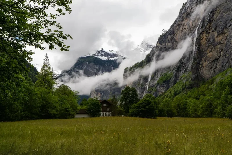
The Gastlosen Tour is a spectacular multi-day hike in the Swiss Alps, renowned for its dramatic limestone peaks, lush alpine meadows, and breathtaking panoramic views. This challenging yet rewarding trek circles the iconic Gastlosen massif, a range often described as the "Swiss Dolomites" due to its jagged, imposing spires. The trail offers a true alpine experience, traversing high mountain passes, crossing remote valleys, and passing by traditional Swiss mountain huts (Berghütten). It's a journey that immerses you in the raw beauty of the pre-Alps, offering a sense of wildness and solitude that is increasingly rare.
- Distance: Approximately 25 km (main loop)
- Elevation Gain: Approximately 1500 m
- Duration: 2 days (recommended for a comfortable experience)
- Difficulty: Moderate to Challenging (due to elevation changes and some exposed sections)
- Season: Mid-June to October (snow-free conditions)
- Closest City: Bulle, Switzerland
- Trailhead Access: Jaun Pass (Pass Jaun)
- Permits: No permits required for hiking
Overview
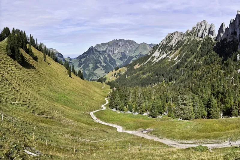
The Gastlosen Tour is a circular route that showcases the unique geological formations and diverse landscapes of the Gruyère region in the canton of Fribourg. Unlike the higher, glaciated peaks of the Bernese Oberland, the Gastlosen are characterised by their striking grey limestone cliffs, which rise dramatically from verdant pastures and dense forests. The tour is typically undertaken over two days, allowing ample time to appreciate the scenery and enjoy the hospitality of the mountain huts.
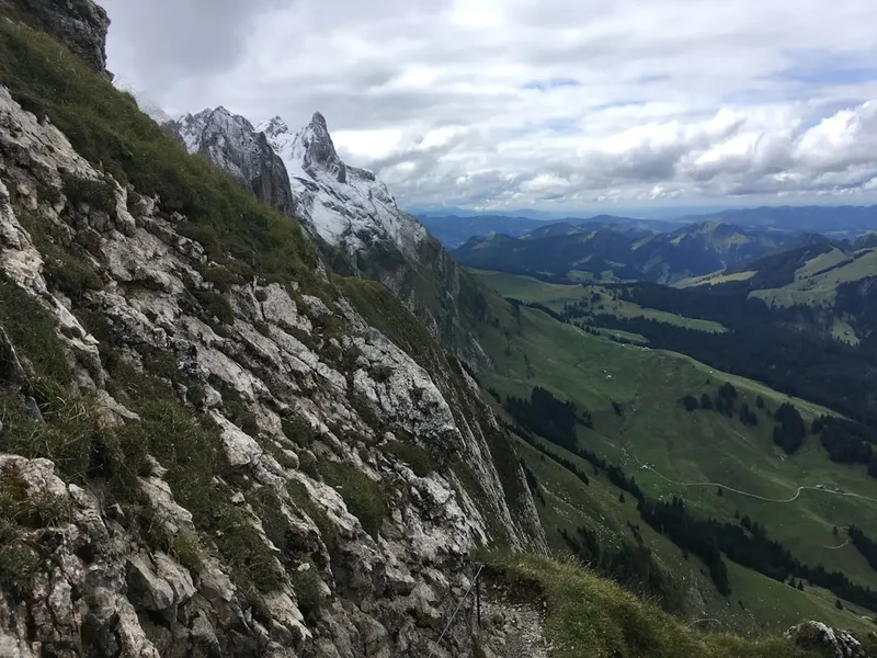
The trail begins and ends at the Jaun Pass, a scenic mountain road connecting the cantons of Fribourg and Bern. From the pass, the route ascends through alpine meadows dotted with wildflowers in summer, offering increasingly spectacular views of the Gastlosen massif. The path winds its way around the base and over the shoulders of these impressive peaks, often following narrow ridges and traversing scree slopes. Key highlights include the impressive rock formations, the panoramic vistas from high passes like the Oberberg Pass, and the charming mountain huts that provide essential rest stops and overnight accommodation.
The terrain is varied, ranging from well-maintained hiking paths to more rugged, rocky sections that require surefootedness and a good head for heights. While not technically demanding in terms of climbing, the sustained ascents and descents, combined with the altitude, make it a physically demanding hike. The sense of remoteness and the sheer scale of the rock formations create an unforgettable hiking experience, making the Gastlosen Tour a must-do for any serious hiker visiting Switzerland.
History and Cultural Context
The Gastlosen massif has long been a significant landmark for local communities, serving as a natural boundary and a source of resources. Historically, the area was used for alpine farming, with shepherds and farmers tending their livestock in the high pastures during the summer months. The traditional mountain huts (Berghütten) that dot the landscape today are a testament to this long-standing agricultural heritage, providing shelter and sustenance for those working the land and, more recently, for hikers exploring the region.
The geological history of the Gastlosen is equally fascinating. These mountains are part of the Helvetic nappes, a series of rock formations that were thrust over younger rock layers during the Alpine orogeny. The limestone itself was formed in ancient seas, and its subsequent uplift and erosion have sculpted the dramatic spires and cliffs that define the massif. The unique geological makeup has also influenced the local flora and fauna, with specific plant species adapted to the calcareous soils.
In more recent times, the Gastlosen have become a popular destination for hikers and climbers. The development of marked trails and the establishment of comfortable mountain huts have made the area accessible to a wider audience. The tour gained prominence as a recognised hiking route in the latter half of the 20th century, as Switzerland increasingly promoted its natural landscapes for tourism. Today, the Gastlosen Tour is a celebrated part of the Fribourg Alps hiking network, offering a blend of natural beauty, geological wonder, and cultural tradition.
Seasonal Highlights and Weather Reality
The Gastlosen Tour is a summer and early autumn hike. The optimal period for undertaking this trek is from mid-June to mid-October, provided there is no significant early or late snowfall.
Late June to August: This is peak summer. The alpine meadows are typically carpeted with a vibrant array of wildflowers, creating a stunning visual spectacle. The days are long, offering ample daylight for hiking. However, this is also the busiest period, and mountain huts may be crowded. Weather can be unpredictable, with the possibility of afternoon thunderstorms, which are common in the Alps during summer. Temperatures at higher elevations can still be cool, especially in the mornings and evenings.
September: This month often offers some of the most stable and pleasant weather for hiking. The crowds begin to thin, and the autumn colours start to appear in the lower valleys, adding another layer of beauty to the landscape. The air is crisp, and visibility is often excellent, providing superb panoramic views. However, the nights become colder, and there is an increased risk of early snowfalls, particularly towards the end of the month.
October: Early October can still be a good time to hike, especially if the weather remains mild. However, the risk of snow increases significantly, and some mountain huts may begin to close for the season. Daylight hours are shorter, and temperatures will be considerably colder. It is crucial to check weather forecasts and snow conditions very carefully before planning a hike in October.
Weather Considerations: The Alps are known for their rapidly changing weather. Even in summer, hikers can experience sunshine, rain, fog, and even snow within a single day. The Gastlosen massif, with its exposed ridges and high passes, is particularly susceptible to sudden weather shifts. It is essential to be prepared for all conditions, regardless of the season.
Recommended Itinerary
2-Day Gastlosen Tour Itinerary
Day 1: Jaun Pass to Gastlosen Hut (Chalet du Soldat)
- Distance: Approximately 12 km
- Elevation Gain: Approximately 800 m
- Time: 4–5 hours
- Start at Jaun Pass (Pass Jaun), easily accessible by car or public transport.
- Follow signs for the Gastlosen Tour, initially ascending through forests.
- Emerge into open alpine meadows with increasingly dramatic views of the Gastlosen peaks.
- The trail climbs steadily towards the Oberberg Pass.
- Enjoy panoramic vistas from the Oberberg Pass, a key viewpoint of the massif.
- Descend slightly towards the Chalet du Soldat (Gastlosen Hut), a charming mountain hut situated in a picturesque location.
- Settle in for the night, enjoy a traditional Swiss meal, and soak in the alpine atmosphere.
- This day focuses on gaining elevation and getting your first close-up views of the iconic rock formations.
Day 2: Gastlosen Hut (Chalet du Soldat) to Jaun Pass
- Distance: Approximately 13 km
- Elevation Gain: Approximately 700 m (with significant ups and downs)
- Time: 5–6 hours
- Depart from the Gastlosen Hut after breakfast.
- The trail continues to circle the Gastlosen massif, offering different perspectives.
- Ascend towards the Col de la Jaman or a similar high point, depending on the exact route variation chosen.
- Traverse sections with exposed paths and scree slopes, requiring careful footing.
- Pass through more alpine pastures and potentially some rocky terrain.
- The route gradually descends back towards the Jaun Pass.
- Enjoy final views of the surrounding pre-Alps as you make your way back to the starting point.
- The descent can be steep in places, so take your time.
- Arrive back at Jaun Pass, completing the circular tour.
- This day offers a more rugged and varied experience, with sustained ascents and descents.
Important Notes:
- Hut bookings are essential, especially during peak season.
- Carry sufficient water, as reliable sources can be scarce between huts.
- Be prepared for changeable mountain weather.
- Sturdy hiking boots are a must.
- The trail can be challenging in places; a good level of fitness is required.
Planning and Bookings
Book Your Trip
Everything you need to plan your journey
Accommodation
Find places to stay near Bulle
Flights
Search flights to Bulle
Essential Preparation
The Gastlosen Tour is a well-established hiking route, but proper preparation is key to a safe and enjoyable experience. The closest major town is Bulle, which serves as a good base for logistical arrangements before and after the hike. Bulle offers a range of accommodation options, from budget hotels to more comfortable establishments, as well as supermarkets for stocking up on supplies and outdoor gear shops.
Access to the trailhead at Jaun Pass (Pass Jaun) is straightforward. It can be reached by car via well-maintained roads from Bulle (approximately 30 minutes). Public transport is also an option: take a train to Bulle and then a bus service that runs regularly to Jaun Pass. Parking is available at the pass, though it can be busy during peak season.
Given the moderate to challenging nature of the hike, a good level of physical fitness is essential. This includes the ability to hike for several hours with significant elevation gain and loss, carrying a backpack. Familiarity with hiking on uneven terrain and rocky paths is also beneficial.
Trail Accommodation
The Gastlosen Tour typically involves an overnight stay in a mountain hut (Berghütte). The most common and recommended hut for this route is the Chalet du Soldat (Gastlosen Hut).
Chalet du Soldat (Gastlosen Hut):
- Booking Requirements: Reservations are highly recommended, especially during the summer months (July and August) and on weekends. Bookings can usually be made directly via the hut's website or by telephone.
- Facilities Provided: Dormitory-style sleeping quarters with mattresses and blankets. A communal dining area where meals are served. Basic toilet facilities. Access to water (treatment recommended). Some huts may offer limited charging facilities for electronic devices, but this should not be relied upon.
- What's NOT Provided: Sleeping bags are usually required (though some huts may provide sheets or blankets, it's best to bring your own). Personal toiletries. Cooking equipment. Food and drinks (these are available for purchase at the hut).
- Seasonal Availability: The hut is typically open from mid-June to mid-October, depending on snow conditions and demand. It's crucial to check the hut's specific opening and closing dates for the year you plan to visit.
- Costs: Prices vary but expect to pay approximately CHF 60-80 per person per night for half-board (dinner and breakfast). Dormitory beds are generally more affordable than private rooms if available.
Alternative Accommodation: While the Chalet du Soldat is the primary hut for the Gastlosen Tour, other nearby huts or guesthouses might be available, though they may require route adjustments. It is advisable to stick to the standard two-day itinerary for the most straightforward experience.
Required Gear
- Hiking Boots: Sturdy, waterproof hiking boots with good ankle support are essential. Ensure they are well broken-in to prevent blisters.
- Waterproof Jacket: A breathable, waterproof and windproof jacket (e.g., Gore-Tex) is crucial for protection against sudden rain and wind.
- Waterproof Overtrousers: Essential for keeping your lower body dry during wet weather.
- Backpack: A comfortable daypack (25-35 litres) for Day 1 and a slightly larger backpack (35-45 litres) if staying overnight, to carry essentials, extra clothing, food, and water. A rain cover for the backpack is highly recommended.
- Warm Layers: A fleece jacket or insulated mid-layer, and a warm hat (beanie) and gloves are necessary, as temperatures can drop significantly at higher altitudes, even in summer.
- Navigation Tools: A detailed hiking map of the area (e.g., SwissTopo 1:25,000 scale), a compass, and a GPS device or smartphone with offline maps are recommended. Familiarity with map reading is important.
- Head Torch: With spare batteries, useful for early starts or late finishes, and for navigating around the hut at night.
- First-Aid Kit: Including blister plasters, bandages, antiseptic wipes, pain relievers, and any personal medications.
- Sun Protection: High SPF sunscreen, sunglasses, and a wide-brimmed hat or cap, as the sun can be intense at altitude.
What to Bring
- Food: While huts provide meals, it's wise to carry high-energy snacks such as trail mix, energy bars, dried fruit, and nuts for consumption during the hike.
- Water: Carry at least 1.5-2 litres of water per person. Refill opportunities may be limited between huts, so plan accordingly. Water purification tablets or a filter are a good backup.
- Toiletries: Biodegradable soap, toothbrush, toothpaste, a small quick-drying towel, and any personal hygiene items.
- Personal Items: Mobile phone (for emergencies, though reception can be patchy), power bank for charging devices, camera, and a small amount of cash (some huts may not accept cards).
- Trekking Poles: Highly recommended for reducing strain on knees during ascents and descents, especially on rocky or steep terrain.
- Insect Repellent: While not as notorious as in some other alpine regions, biting insects can be present, especially near water sources or in the evenings.
- Duct Tape: A small roll can be incredibly useful for emergency repairs to gear.
Permits
The Gastlosen Tour is a public hiking trail and does not require any specific permits for access or passage. The trails are maintained by local authorities and hiking associations, and the mountain huts operate independently or under concession.
However, it is crucial to note the following regarding access and usage:
- Hut Bookings: As mentioned in the "Trail Accommodation" section, booking your overnight stay at the Chalet du Soldat (Gastlosen Hut) is essential, especially during the peak hiking season (July-September) and on weekends. Failure to book can result in being turned away, as huts have limited capacity.
- National Park Regulations: While the Gastlosen Tour is not within a strictly regulated national park like some other Swiss hiking areas, general principles of responsible outdoor behaviour apply. This includes respecting the environment, staying on marked trails, and adhering to any local signage or guidelines.
- Private Land: Parts of the route may cross private land used for alpine farming. Hikers are expected to respect these areas, close gates behind them if applicable, and avoid disturbing livestock.
The simplicity of not requiring permits makes the Gastlosen Tour an accessible and appealing option for many hikers. The primary requirement is to ensure you have secured accommodation if planning an overnight stay.
Other Activities in the Area
The region surrounding the Gastlosen offers a variety of activities for those looking to extend their stay or explore beyond the hiking trail:
- Exploring Bulle: The main town in the Gruyère region, Bulle is famous for its cheese. Visit the Gruyère Castle and the Maison du Gruyère cheese dairy to learn about the production of this world-renowned cheese. The town also offers charming streets, local shops, and restaurants.
- Via Ferrata: For the more adventurous, there are Via Ferrata routes in the vicinity, offering a thrilling way to experience the rock faces of the Alps. The Via Ferrata of Moléson, near Bulle, is a popular choice.
- Cycling: The roads around Jaun Pass and the Gruyère region are popular with cyclists, offering scenic routes with challenging climbs and descents.
- Paragliding: The open terrain and thermal conditions in the pre-Alps make it a good area for paragliding. Tandem flights can be arranged for those wanting to experience the landscape from above.
- Lake Gruyère: This artificial lake offers opportunities for watersports, boat trips, and relaxing by the water.
- Other Hiking Trails: The Fribourg Alps are crisscrossed with numerous hiking trails of varying difficulty, allowing for further exploration of the diverse landscapes.
Safety and Conditions
Pre-Hike Checks:
- Weather Forecast: Always check the latest weather forecast for the Jaun Pass and surrounding mountain regions before you set off. Websites like MeteoSwiss or local weather services provide detailed mountain forecasts. Be prepared for rapid changes.
- Trail Conditions: While the main Gastlosen Tour is generally well-maintained, early or late season snow can make sections impassable or hazardous. Check with local tourist information or the mountain hut directly for current trail conditions.
- Emergency Contacts: Save emergency numbers in your phone: 112 (European emergency number), 144 (ambulance), 117 (police), 1414 (REGA - Swiss Air Rescue).
On the Trail:
- Navigation: While the trail is marked, always carry a map and compass and know how to use them. Do not rely solely on GPS devices or phone apps, as batteries can die and signal can be lost.
- Terrain: Be aware that some sections of the trail can be steep, rocky, and exposed. Maintain a steady pace, watch your footing, and do not take unnecessary risks, especially in poor visibility or wet conditions.
- Altitude: The Gastlosen Tour reaches moderate altitudes (around 2000 metres). While altitude sickness is less common at these elevations than in the high Alps, be aware of its symptoms (headache, nausea, dizziness) and descend if they occur.
- Water: Carry sufficient water. Refill opportunities may be limited, and stream water should ideally be treated or filtered.
- Communication: Mobile phone reception can be patchy in mountainous areas. Inform someone of your hiking plans, including your intended route and expected return time. Consider carrying a personal locator beacon (PLB) for remote areas.
- Wildlife: While large predators are rare, be aware of farm animals in pastures and respect their space.
Mountain Hut Safety: Follow the rules and guidelines of the mountain huts. Be considerate of other guests, especially regarding noise levels and shared facilities. Ensure you have adequate lighting for navigating around the hut at night.
Travel Insurance: It is highly recommended to have travel insurance that covers hiking and potential mountain rescue or medical evacuation.
Side Trips and Points of Interest
Oberberg Pass: This is a significant viewpoint on Day 1 of the tour. From the pass, you are treated to a spectacular, unobstructed panorama of the entire Gastlosen massif. It's an ideal spot for photography and to appreciate the scale and unique geology of the rock formations.
Chalet du Soldat (Gastlosen Hut): Beyond being a place to rest, the hut itself is a point of interest. Its location is incredibly scenic, nestled amidst alpine meadows with the imposing Gastlosen peaks as a backdrop. The atmosphere in a traditional Swiss mountain hut is a unique experience in itself.
Geological Formations: The entire Gastlosen massif is a point of interest. The jagged limestone spires, sheer cliffs, and dramatic rock formations are a result of millions of years of geological processes. Take time to observe the different rock layers and erosion patterns.
Alpine Flora and Fauna: Depending on the season, the alpine meadows are rich with wildflowers. Keep an eye out for various species of gentians, edelweiss (though rare), alpine roses, and other mountain flora. You might also spot marmots, chamois, or various bird species.
Variations to the Route: While the standard two-day tour is highly recommended, experienced hikers with good navigation skills might explore minor variations or extensions. However, it's crucial to consult detailed maps and local advice before deviating from the marked trails.
Leave No Trace
The Gastlosen Tour traverses a beautiful and sensitive alpine environment. Practising Leave No Trace principles ensures that this natural beauty is preserved for future generations and that the impact of hikers is minimised.
Plan Ahead and Prepare: Research the trail, understand its challenges, and be prepared for all weather conditions. Book accommodation in advance to avoid disappointment and overcrowding.
Travel and Camp on Durable Surfaces: Stick to marked trails. Avoid cutting switchbacks, as this causes erosion. If camping were permitted (which it generally is not on this route, except in designated areas if applicable), you would camp on durable surfaces like rock, gravel, or dry grass, at least 70 metres from water sources.
Dispose of Waste Properly: Pack out everything you pack in. This includes all food scraps, wrappers, and any other litter. Use the toilet facilities provided at mountain huts. If no facilities are available, dig a cathole at least 15 cm deep and 60 metres from water, trails, and campsites, and bury human waste. Pack out used toilet paper.
Leave What You Find: Do not pick wildflowers, disturb rocks, or remove any natural or cultural objects. Let others enjoy the natural beauty as you found it.
Minimise Campfire Impacts: Campfires are generally not permitted on this route, especially at higher altitudes and near huts. If they were allowed in specific designated areas, use existing fire rings and keep fires small.
Respect Wildlife: Observe wildlife from a distance. Never feed animals, as this can disrupt their natural behaviours and diets, and can be harmful to their health. Store food securely to prevent attracting animals.
Be Considerate of Other Visitors: Keep noise levels down, especially in huts and natural areas. Yield to other hikers on narrow trails. Respect the peaceful nature of the alpine environment.