Franz Josef Glacier Valley Walk - A Journey into the Heart of Kā Roimata o Hine Hukatere
The Franz Josef Glacier Valley Walk offers a profound encounter with one of the most dynamic and powerful natural features in the Southern Hemisphere. Known in Te Reo Māori as Kā Roimata o Hine Hukatere ('The Tears of Hine Hukatere'), the Franz Josef Glacier is a 12-kilometre-long temperate maritime glacier located within the Te Wāhipounamu South West New Zealand World Heritage Area. This walk is not merely a stroll to a viewpoint; it is a journey through a landscape in constant flux, where the raw power of ice, water, and tectonic movement is visible in every scoured rock and braided river channel. Unlike many glaciers globally that require arduous multi-day treks to access, Franz Josef descends from the high peaks of the Southern Alps / Kā Tiritiri o te Moana into a lush, temperate rainforest, terminating just a few hundred metres above sea level. This accessibility makes it a world-class destination for those seeking to witness the effects of glaciation firsthand.
- Distance: 5.4 km return
- Duration: 1.5 - 2 hours
- Season: All year round (subject to weather and river conditions)
- Difficulty: Easy (mostly flat, though the riverbed section is rocky and uneven)
- Highest point: Approximately 250 m
- Closest Town: Franz Josef / Waiau (5 km from the trailhead)
- Access: Glacier Access Road, south of Franz Josef village
Overview
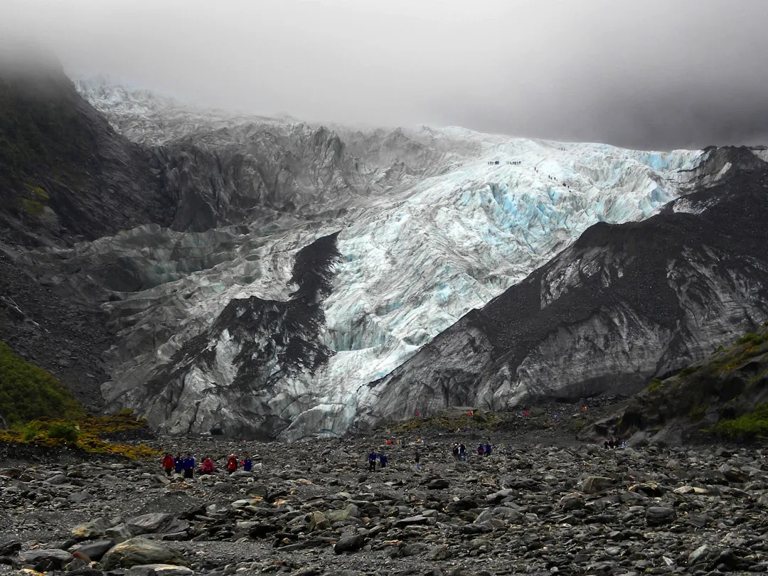
The Franz Josef Glacier Valley Walk is a masterclass in geological storytelling. The trail begins in a dense, emerald-green rainforest, where ancient kamahi and rātā trees are draped in epiphytic ferns and thick carpets of moss. As you emerge from the forest canopy, the landscape opens into the vast, grey expanse of the Waiho River valley. This is a "proglacial" environment—a zone recently vacated by retreating ice—where the ground is composed of terminal and lateral moraines, crushed schist, and silt-laden glacial meltwater. The scale of the valley is humbling; the towering walls of the Southern Alps rise precipitously on either side, scarred by the passage of ice that, only a century ago, filled the entire valley to a height of several hundred metres.
The walk follows the path of the retreating ice. Because the glacier is exceptionally sensitive to climatic changes, its terminal face can advance or retreat by several metres in a single day. In recent decades, the retreat has been dramatic, meaning the walk today is longer than it was twenty years ago, and the viewpoint is further from the ice. However, the journey remains spectacular. You will pass massive waterfalls cascading down vertical rock faces—most notably the Trident Falls—and cross numerous small streams that feed into the main Waiho River. The final viewpoint provides a safe but awe-inspiring perspective of the glacier's terminal face, where the blue-tinged ice meets the grey riverbed, and the sheer scale of the icefall above becomes apparent.
This is a landscape defined by the elements. The West Coast of New Zealand is one of the wettest places on Earth, receiving over 5,000 mm of rainfall annually. This precipitation is what fuels the glacier; heavy snow in the "neve" (the high-altitude collection area) is compressed into ice and pushed down the valley by gravity. When it rains here, the valley transforms. Small trickles become thundering torrents, and the Waiho River can rise with terrifying speed. Consequently, the walk is subject to daily safety assessments by the Department of Conservation (DOC). Despite its "easy" rating, the environment is high-risk, and walkers must respect all barriers and signage designed to protect them from rockfall and sudden flooding.
History and Cultural Context
The cultural significance of the Franz Josef Glacier is deeply rooted in the traditions of Ngāi Tahu, the iwi (tribe) that holds manawhenua (territorial authority) over this region. To Māori, the glacier is known as Kā Roimata o Hine Hukatere. According to oral tradition, a fearless young woman named Hine Hukatere loved climbing in the mountains. She persuaded her lover, Wawe, to join her. Tragically, Wawe was swept away by an avalanche and killed. Hine Hukatere was heartbroken, and her immense grief caused her to weep uncontrollably. The gods, pitying her, froze her flowing tears into the great river of ice that remains today. This legend imbues the landscape with a sense of spiritual weight, reminding visitors that the glacier is more than a geological curiosity—it is a place of ancestral connection and story.
European history in the valley began in the mid-19th century. The glacier was first sighted by Europeans from the sea in 1859 by the crew of the ship Mary Louisa. However, it was the German explorer and geologist Julius von Haast who, in 1865, named it "Franz Josef" in honour of the Emperor of the Austro-Hungarian Empire. Haast was struck by the anomaly of a glacier terminating so close to the sea amidst subtropical vegetation. In the late 1800s and early 1900s, the glacier became a focal point for early New Zealand tourism. The Graham brothers, Alec and Peter, were legendary mountain guides who established the first formal guiding services in the valley, leading Victorian-era tourists onto the ice in long skirts and heavy woollen coats, using steps cut by hand with ice axes.
Throughout the 20th century, the glacier served as a vital laboratory for glaciologists. It is one of the fastest-moving glaciers in the world, sometimes flowing at rates of up to four metres per day. This rapid movement, combined with its sensitivity to temperature and snowfall, has made it a "canary in the coal mine" for climate change. The history of the walk itself is one of constant adaptation; as the glacier has retreated and the riverbed has shifted, the Department of Conservation has had to repeatedly relocate the track and viewpoints to ensure public safety while maintaining access to this magnificent natural wonder.
Want more background? Read extended notes on history and cultural context → Learn more
Seasonal Highlights and Weather Reality
The Franz Josef Glacier Valley Walk is open year-round, but the experience varies significantly depending on the season and, more importantly, the immediate weather conditions. The West Coast does not have a "dry season"; rain is a constant possibility, and visitors should be prepared for wet weather regardless of the month. However, the character of the valley shifts with the turning of the year.
Winter (June to August): Many locals consider winter the best time to visit. While temperatures are cooler (ranging from 2°C to 12°C), winter often brings long periods of settled, high-pressure weather. These "bluebird" days offer the clearest views of the glacier and the surrounding peaks, with the crisp air making the blue of the ice appear even more vibrant. Snow may occasionally fall on the valley floor, though it rarely lingers. The surrounding mountains are heavily laden with snow, providing a stunning backdrop for photography.
Spring (September to November): This is a season of transition and high water volume. As the snow begins to melt in the high country and spring rains arrive, the waterfalls in the valley—such as the Trident Falls—reach their peak flow. The rainforest section of the walk is particularly lush during this time, with new growth appearing on the ferns and mosses. However, spring can also be the most volatile season for weather, with frequent storms that may lead to temporary track closures due to river flooding.
Summer (December to February): Summer brings the warmest temperatures (15°C to 22°C) and the longest daylight hours. This is the peak tourist season, and the trail can be quite busy. The glacier's retreat is often most visible in summer as the warmer air increases the rate of melting at the terminal face. While the weather is warmer, summer also brings the notorious West Coast sandflies, which are most active on calm, humid days. Heavy tropical-origin rainstorms are also common in summer, which can cause the Waiho River to rise rapidly.
Autumn (March to May): Autumn often provides stable weather similar to winter but with milder temperatures. The light in the valley becomes softer and more golden, which is excellent for photography. The crowds of mid-summer begin to thin, offering a more solitary experience. Like spring, autumn is a time when the rainforest is exceptionally vibrant after the summer rains.
Weather Reality: Regardless of the season, the "Glacier Valley" weather is unpredictable. It is common to experience "four seasons in one day." The most critical factor is rainfall; if there has been heavy rain in the previous 24 hours, the track may be closed or restricted. Always check the daily status at the Westland Tai Poutini National Park Visitor Centre before heading to the trailhead.
Recommended Itinerary
Franz Josef Glacier Valley Route Progression
Phase 1: The Rainforest Approach (Trailhead to Sentinel Rock Turn-off)
- Distance: 1.2 km
- Time: 20 minutes
- The journey begins at the car park at the end of Glacier Access Road.
- The first section is a well-graded gravel path that winds through ancient podocarp rainforest.
- Look for the massive rātā trees and the delicate "kidney ferns" (Raurenga) that carpet the forest floor.
- The air here is cool and damp, smelling of earth and wet stone.
- This section is almost entirely flat and provides a gentle warm-up.
- You will pass several information panels detailing the history of the glacier's retreat.
Phase 2: The Valley Floor and Riverbed (Sentinel Rock to the Viewpoint)
- Distance: 1.5 km
- Time: 30–40 minutes
- As you leave the forest, the track transitions onto the rocky bed of the Waiho River.
- The terrain becomes more uneven, consisting of loose stones, gravel, and larger boulders.
- The path is marked by poles; it is essential to follow these, as the river channels can shift overnight.
- You will cross several small streams via footbridges or stepping stones.
- To your left, the Trident Falls cascade down the steep valley walls—a spectacular sight, especially after rain.
- The scale of the valley walls becomes apparent here, with the polished schist showing the "striations" (scratches) left by the glacier as it ground past.
Phase 3: The Final Ascent and Glacier Viewpoint
- Distance: 0.5 km
- Time: 15 minutes
- The final section involves a short, steady climb onto a stable moraine ridge.
- This is the only significant elevation gain on the walk (approximately 100 m).
- The track leads to a fenced safety barrier that offers the best available view of the glacier's terminal face.
- From here, you can see the "icefall"—the frozen cascade of ice tumbling down from the upper neve.
- Listen closely; you may hear the "groaning" of the ice or the distant thunder of a rockfall.
- Take time to appreciate the blue hues of the ice, caused by the density of the crystals absorbing all colours of the spectrum except blue.
Phase 4: The Return Journey via Sentinel Rock
- Distance: 2.7 km
- Time: 45 minutes
- Retrace your steps back down the valley floor.
- On the way back, take the short 10-minute detour up to Sentinel Rock.
- Sentinel Rock is a "roche moutonnée"—a knob of bedrock that was smoothed and shaped by the glacier.
- The view from the top of Sentinel Rock provides a fantastic "before and after" perspective, showing how much the glacier has retreated since the early 1900s.
- Continue back through the rainforest to the car park.
Important Notes:
- The track is subject to change. DOC staff frequently move the markers to account for river shifts.
- Never cross the safety barriers at the final viewpoint. The area beyond is highly unstable due to rockfall and ice collapse.
- The total return time is approximately 1.5 to 2 hours, but allow extra time for photography and reading the interpretive signs.
- There are no toilets on the track; use the facilities at the car park before starting.
Planning and Bookings
Book Your Trip
Everything you need to plan your journey
Accommodation
Find places to stay near Franz Josef
Flights
Search flights to Franz Josef
Essential Preparation
The Franz Josef Glacier Valley Walk is a day hike that requires no bookings or fees, making it one of the most accessible high-value experiences in New Zealand. However, "easy" access does not mean "no preparation." The primary logistical hub is the village of Franz Josef / Waiau, located 5 km north of the trailhead. This small, vibrant town is geared entirely toward glacier tourism and provides all the necessary services for walkers.
Logistics and Transport:
- By Car: Most visitors arrive via State Highway 6. The drive from Hokitika takes approximately 2 hours, while the drive from Wanaka takes about 4 to 5 hours. The Glacier Access Road is well-signposted just south of the village.
- Shuttles: For those without a vehicle, several local operators run regular shuttle services from the village to the trailhead car park. These usually run every hour during the peak season.
- Walking/Cycling: A dedicated walking and cycling track (the Te Ara a Waiau Walkway) connects the village to the glacier car park. This adds about 4 km (one way) to your journey and is a beautiful way to see the forest.
- Fitness: The walk is suitable for people of all ages and moderate fitness levels. The main challenge is the uneven footing on the riverbed section. If you have weak ankles, sturdy footwear is highly recommended.
Trail Accommodation
This is a day hike requiring no overnight accommodation on the trail itself. Camping is strictly prohibited within the glacier valley due to the high risk of flooding and rockfall. However, the nearby village of Franz Josef / Waiau offers a wide range of accommodation to suit all budgets.
Accommodation Options in Franz Josef Village:
- Backpackers and Hostels: Several high-quality hostels offer dorm beds and private rooms, often including communal kitchens and hot tubs (perfect for after the walk).
- Motels and Hotels: A variety of mid-range motels and luxury hotels are available. It is highly recommended to book in advance during the summer months (December–February).
- Holiday Parks: There are two major holiday parks in the village offering powered sites for campervans, tent sites, and basic cabins.
- Department of Conservation Campsites: The nearest DOC campsite is at Otto/MacDonalds on the shores of Lake Mapourika, about 15 minutes north of the village. This is a beautiful, low-cost option but has basic facilities (long-drop toilets and cold water).
Required Gear
While the walk is short, the West Coast environment demands respect. Do not be fooled by sunny skies at the trailhead; the weather can change in minutes.
- Footwear: Sturdy walking shoes or hiking boots with good grip. The riverbed section is rocky, slippery when wet, and requires stable footing. Avoid flip-flops or smooth-soled fashion sneakers.
- Rain Jacket: A high-quality waterproof jacket is essential. The West Coast is famous for its sudden, heavy downpours. A "breathable" waterproof layer (like Gore-Tex) is best.
- Warm Layers: Even in summer, the wind blowing off the glacier (the "katabatic wind") can be very cold. Bring a fleece or woollen mid-layer.
- Sun Protection: The New Zealand sun is exceptionally strong due to low pollution and a thin ozone layer. Wear a hat, sunglasses, and SPF 50+ sunscreen, even on cloudy days.
- Mobile Phone: For photography and emergencies. Note that signal can be patchy in the deep valley but is generally available at the car park and the main viewpoints.
What to Bring
Since the walk is only 2 hours, you do not need to carry a heavy pack, but these items will make your journey more comfortable:
- Water: Bring at least 1 litre of water per person. While there is plenty of water in the valley, the glacial meltwater is full of "rock flour" (fine silt) and is not suitable for drinking without heavy filtration.
- Snacks: High-energy snacks like nuts, chocolate, or fruit. There are no food outlets at the trailhead.
- Insect Repellent: Essential for warding off the persistent West Coast sandflies. Look for repellents containing DEET or Picaridin.
- Camera/Binoculars: The scale of the glacier is best appreciated with binoculars, which allow you to see the deep blue crevasses and the texture of the icefall.
- Personal Medications: Especially if you suffer from allergies or asthma, as the forest can be high in pollen and the air near the glacier is very dry.
- Small First Aid Kit: Including plasters (band-aids) for blisters and antiseptic wipes.
Permits
No permits or bookings are required to walk the Franz Josef Glacier Valley Walk. Access to the Westland Tai Poutini National Park is free for all visitors. This is part of New Zealand's commitment to ensuring that its most spectacular natural heritage remains accessible to everyone.
Key Information:
- Entry Fees: None.
- Parking: Free parking is available at the Glacier Access Road end. However, during peak summer periods (10:00 AM to 3:00 PM), the car park can fill up quickly. Arriving early or late in the day is recommended.
- Commercial Guiding: If you wish to walk *on* the ice, you must book a heli-hike with a licensed commercial operator. Walking onto the glacier from the valley floor is no longer possible due to the retreat of the ice and the instability of the terminal face. These tours require permits, which are handled by the tour operators.
- Drone Use: The use of drones is strictly prohibited in the National Park without a specific concession from the Department of Conservation. This is to protect the privacy of other walkers, the safety of the frequent helicopter flights in the area, and the natural quiet of the wilderness.
- Dogs: Dogs and other pets are not permitted in the National Park to protect the native birdlife, including the rare Rowi kiwi which lives in the surrounding forests.
Daily Status Checks: While no permit is needed, the track is frequently closed due to "Force Majeure" events (flooding, rockfall, or landslides). Before you drive to the trailhead, it is highly recommended to check the "Track Status" board at the DOC Visitor Centre in the village or check the official DOC website. If the "Track Closed" sign is up, do not attempt to enter the valley; the risks are genuine and potentially fatal.
Other Activities in the Area
The Franz Josef region is a hub for outdoor adventure and relaxation. Consider these activities to round out your visit:
- Heli-Hike Adventures: The only way to actually stand on the glacier. A short helicopter flight takes you onto the upper ice, where professional guides lead you through ice caves and crevasses. This is a premium experience but offers an unparalleled perspective on the glacier.
- Glacier Hot Pools: Located in the heart of the village, these pools are fed by local spring water and nestled in lush rainforest. They are the perfect way to soothe muscles after a day of walking.
- Lake Mapourika Kayaking: Just north of the village, this stunning lake offers mirror-like reflections of the Southern Alps. Guided kayak tours explore the Okarito Kiwi Sanctuary on the far shore.
- Okarito Lagoon: A 25-minute drive from Franz Josef, this is New Zealand's largest unmodified wetland. It is a haven for birdlife, including the Kotuku (Great White Heron). You can explore by kayak or take a guided boat tour.
- Skydive Franz Josef: For the ultimate adrenaline rush, skydive from up to 6,096 m, offering views of the glaciers, the mountains, and the Tasman Sea simultaneously.
- The Terrace Walk: A short, easy night walk near the village where you can see glowworms in the forest banks.
- West Coast Wildlife Centre: Located in the village, this is the best place to see the Rowi kiwi (the rarest kiwi species) and the Tuatara in a controlled environment.
Safety and Conditions
The Reality of a Dynamic Environment: The Franz Josef Glacier Valley is one of the most hazardous tracks managed by the Department of Conservation. This is not due to the difficulty of the walking, but the volatility of the landscape. You are entering a zone of active geological change.
Rockfall and Ice Collapse: The valley walls are composed of fractured schist that has been weakened by the pressure of the glacier. As the ice retreats, it leaves these walls unsupported, leading to frequent rockfalls. Similarly, the terminal face of the glacier is a wall of unstable ice that can collapse without warning. Never cross the safety barriers. People have been killed by ice collapses and rockfalls after ignoring these signs.
Flash Flooding: The Waiho River is a "braided" river that can change its course in minutes. Heavy rain in the mountains—even if it is not raining at the car park—can cause the river to surge. If you notice the water level rising or the water becoming significantly muddier, leave the valley floor immediately. Do not attempt to cross any water that is more than knee-deep or flowing swiftly.
Weather Awareness:
- Check the MetService mountain forecast for "Westland National Park" before heading out.
- Be aware of "Wind Chill." The wind coming off the glacier is significantly colder than the air in the village.
- In the event of heavy rain, the track will likely be closed. Respect these closures; they are based on real-time monitoring of river levels.
Sandflies: While not a safety "hazard" in the traditional sense, sandflies can make your experience miserable if you are unprepared. They do not carry diseases in New Zealand, but their bites are itchy and can become infected if scratched. Apply repellent before you leave your vehicle.
Emergency Services: There is no permanent rescue base at the trailhead. In an emergency, dial 111. However, be aware that mobile coverage is unreliable once you are deep in the valley. If you are walking alone, always tell someone your intentions and expected return time.
Side Trips and Points of Interest
Sentinel Rock: This is the most important side trip in the valley. A short, 10-minute climb from the main track leads to the top of this impressive rock formation. In 1909, the glacier's ice was level with the top of this rock. Today, the ice is kilometres away. The interpretive panels here provide a sobering look at the reality of glacial retreat and offer a panoramic view of the entire lower valley.
Peter's Pool: Located just a short walk from the main car park (on the Douglas Walk loop), this small "kettle lake" was formed by the melting of a large block of ice left behind by the retreating glacier. On a calm day, the pool provides a perfect mirror reflection of the glacier and the mountains. It is an easy, 20-minute return walk and is wheelchair accessible.
The Douglas Walk: This 1-hour loop track starts near the main car park and takes you through a succession of forest types, from the "pioneer" lichens and mosses on the newest moraines to the ancient podocarp forest on the older terraces. It is a great way to understand how the forest "reclaims" the land once the ice has gone.
Trident Falls: While you cannot walk to the base of these falls due to safety restrictions, they are a prominent feature of the valley walk. These three-tiered falls are particularly spectacular after rain and provide a sense of the immense volume of water moving through this landscape.
Waiho River Braids: Take a moment to observe the river itself. The grey colour comes from "glacial flour"—fine particles of rock ground down by the glacier. The river is constantly shifting its path, creating a complex network of channels that is a classic example of a braided river system.
Leave No Trace
The Westland Tai Poutini National Park is a pristine wilderness area. With thousands of visitors each year, it is vital that every walker follows the Leave No Trace principles to preserve the valley for future generations.
Your Responsibility:
- Pack it in, Pack it out: There are no rubbish bins on the trail. Take all your litter, including organic waste like fruit peels and nut shells, back to the village for disposal. Organic waste can attract pests and takes a long time to decompose in the cold glacial environment.
- Stay on the Track: The "pioneer" plants (lichens and mosses) that grow on the recently vacated riverbed are extremely fragile. Stepping on them can destroy years of growth and delay the natural reforestation of the valley.
- Respect Wildlife: You may see the Kea (the world's only alpine parrot) in the car park or on the trail. Never feed them. Feeding Kea makes them dependent on humans, leads to poor health, and encourages dangerous behaviour around vehicles.
- Toileting: Use the toilets at the car park before you start. If you are caught short, ensure you are at least 50 metres away from any water source and bury waste deeply. However, given the short duration of the walk, this should be avoidable.
- Water Purity: Do not use soaps or detergents in the streams. Even biodegradable soaps can harm the delicate aquatic life in the glacial meltwater.
- Take Only Photos: Do not remove rocks, plants, or any other natural features from the valley. The schist rocks are beautiful, but they belong in the landscape.