Fjordland Coastal Route - The Untamed Edge of the World
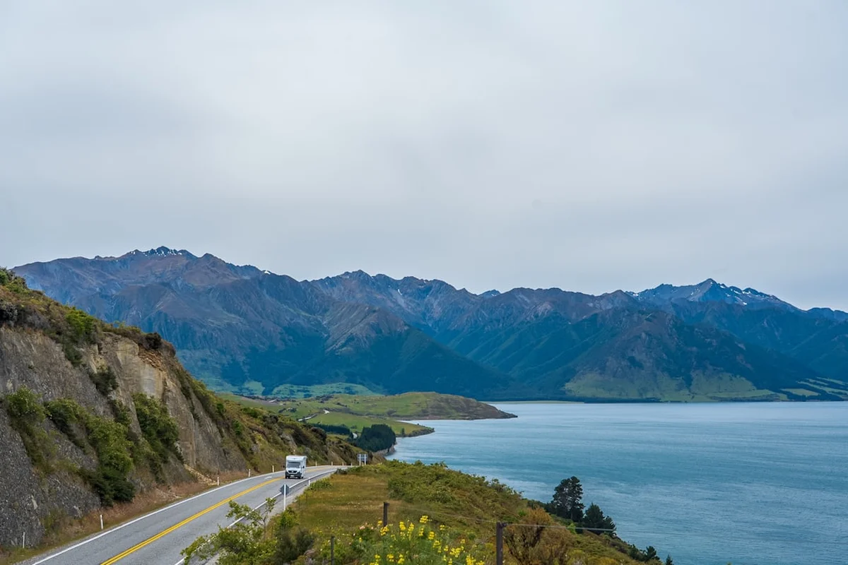
The Fjordland Coastal Route is a premier wilderness expedition that traverses the rugged, salt-sprayed fringes of New Zealand’s largest national park. Spanning 60.0 kilometres of ancient temperate rainforest, secluded granite coves, and dramatic ridgelines, this 3-to-4-day journey offers a raw and visceral connection to the Fiordland landscape. Unlike the more manicured Great Walks, the Coastal Route provides a sense of profound isolation, where the rhythm of the day is dictated by the tides of the Tasman Sea and the unpredictable weather systems of the Roaring Forties. Starting with a boat journey across the deep, mysterious waters of Lake Manapouri, walkers are deposited at the very edge of the wilderness, far from road noise and cellular signals. This is a track for those who seek the silence of the bush, the roar of the ocean, and the challenge of navigating one of the most pristine ecosystems remaining on Earth.
- Distance: 60.0 km total
- Duration: 3–4 days
- Season: November to April (optimal conditions; winter travel requires advanced navigation and survival skills)
- Accommodation: Backcountry huts and designated wilderness campsites
- Elevation Gain: 500 m (predominantly coastal with undulating forest terrain)
- Difficulty: Moderate (requires good fitness and experience with muddy, root-filled tracks)
- Access: Boat transport from Pearl Harbour, Manapouri is essential for trailhead access
Overview
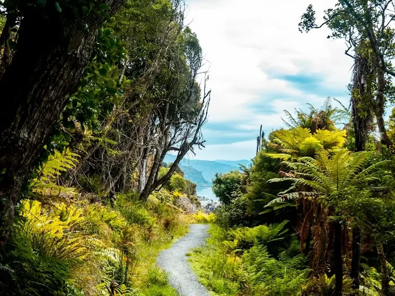
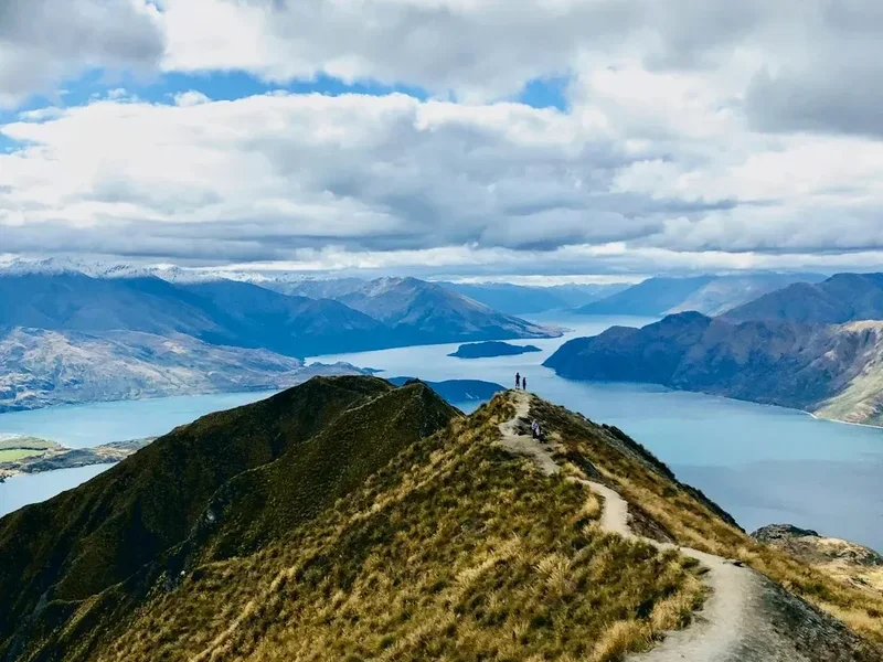
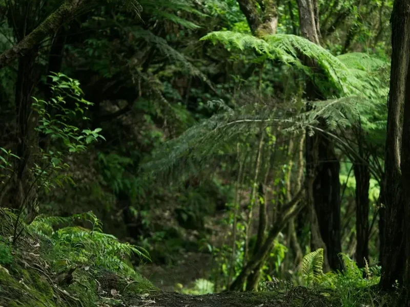
The Fjordland Coastal Route is a masterclass in ecological diversity, transitioning seamlessly from the towering podocarp forests of the interior to the wind-stunted "goblin forests" that cling to the coastal cliffs. While the total elevation gain of 500 metres may suggest a flat journey, the reality of the terrain is far more engaging. The path winds through a labyrinth of massive tree roots, crosses crystal-clear mountain streams, and traverses sandy beaches where the only footprints are likely to be your own or those of the local birdlife. The geology of the region is dominated by ancient gneiss and granite, carved by successive glaciations into the deep fiords and steep-sided valleys that define the South West New Zealand World Heritage Area (Te Wāhipounamu).
Water is the defining element of this route. Fiordland is one of the wettest places on the planet, receiving upwards of 7,000 mm of rainfall annually in certain sectors. This constant moisture fuels a prehistoric landscape where every surface is draped in a thick carpet of emerald moss, and epiphytic ferns grow high in the canopy of Rimu and Miro trees. When the rain falls—as it frequently does—the forest transforms into a shimmering, silver world of temporary waterfalls and rising mists. Conversely, on the rare days when the sun breaks through, the coastal vistas across the Tasman Sea are nothing short of breathtaking, with the deep blue of the ocean contrasting against the stark white of the granite peaks.
The route is designed for walkers who appreciate the subtleties of the bush. It is not a journey of constant alpine passes, but rather one of intimate encounters with nature. You might find yourself sharing a beach with a New Zealand fur seal (kekeno) or watching the inquisitive South Island robin (toutouwai) hop around your boots at a rest stop. The isolation of the Fjordland Coastal Route ensures that the human impact remains minimal, preserving a sense of discovery that is increasingly rare in the modern world. It is a journey that demands physical resilience and a spirit of adventure, rewarding the prepared walker with a deep sense of peace and a renewed respect for the power of the natural world.
History and Cultural Context
The history of the Fjordland Coastal Route is a tapestry of Māori voyaging, European exploration, and the rugged industry of early settlers. For centuries, Ngāi Tahu Māori utilised the coastal fringes of Fiordland as seasonal bases for gathering kai moana (seafood) and hunting the now-extinct moa. The region was also a vital source of pounamu (greenstone), which was highly prized for its strength and spiritual significance. The coastal routes were treacherous, requiring intimate knowledge of the tides and weather patterns, and the land remains deeply sacred to Ngāi Tahu as part of their ancestral heritage.
European contact began in the late 18th century, with Captain James Cook charting the coastline during his second voyage in 1773. Cook’s descriptions of the "dreadful" and "mountainous" terrain did little to deter the sealers and whalers who followed in the early 1800s. These hardy individuals established temporary camps in the sheltered coves along the route, leaving behind remnants of stone hearths and rusted ironwork that can still be found by the observant walker. The mid-19th century brought surveyors and explorers, such as Quintin MacKinnon and Donald Sutherland, who sought to map the interior and find overland routes to the fiords. Their efforts were often hampered by the impenetrable bush and the relentless rain, yet their legacy is preserved in the names of the landmarks and peaks that surround the track.
In the 20th century, the focus shifted from exploitation to preservation. The establishment of Fiordland National Park in 1952 marked a turning point, ensuring that the unique biodiversity of the coastal route would be protected for future generations. Today, the track is managed by the Department of Conservation (DOC), which maintains the delicate balance between providing access to this spectacular wilderness and protecting its fragile ecosystems. Walking the Fjordland Coastal Route is, in many ways, a walk through time, where the stories of the past are whispered in the wind that blows off the Tasman Sea.
Want more background? Read extended notes on history and cultural context → Learn more
Seasonal Highlights and Weather Reality
The Fjordland Coastal Route is best experienced during the southern hemisphere’s late spring, summer, and early autumn (November to April). During this window, the days are long, and the temperatures are generally mild, ranging from 10°C to 20°C. However, walkers must be prepared for the "Fiordland Factor"—the reality that extreme weather can occur at any time of year. Snow is possible on the higher ridges even in mid-summer, and heavy rain is a constant possibility.
Spring (November to December) is a time of vibrant growth. The forest is alive with the calls of nesting birds, and the alpine flowers begin to bloom in the clearings. This is also the time when the waterfalls are at their most powerful, fed by the last of the winter snowmelt. Summer (January to February) offers the most stable weather and the warmest temperatures, making the coastal sections particularly enjoyable. However, this is also the peak season for sandflies, which can be a significant nuisance in sheltered areas. Autumn (March to April) brings cooler, crisper air and a change in the light that is a dream for photographers. The sandfly population begins to dwindle, and the forest takes on a quiet, contemplative atmosphere.
Winter (May to October) transforms the route into a challenging environment suitable only for expert backcountry travellers. Many of the smaller streams can become impassable after heavy rain, and the track can be obscured by snow or fallen debris. The Department of Conservation often removes bridges on certain sections to prevent damage from avalanches or floods, and the huts operate with limited facilities. For most walkers, the winter months are a time to plan and prepare for the following season, rather than to venture onto the track.
Recommended Itinerary
4-Day Fjordland Coastal Route Itinerary
Day 1: Pearl Harbour to Hope Arm Hut
- Distance: 12.0 km
- Elevation gain: 150 m
- Time: 4–5 hours
- Begin with a pre-booked boat transfer from Pearl Harbour, Manapouri, across the lake to the Stockyard Cove trailhead.
- The track starts with a gentle climb through mature beech and podocarp forest.
- Pass through the "Gnome Forest," a section of stunted trees covered in thick, hanging lichens.
- Arrive at Hope Arm Hut, situated on a beautiful sandy beach overlooking Lake Manapouri.
- Spend the afternoon exploring the shoreline or swimming in the cool, clear lake waters.
- The hut provides a social atmosphere and a chance to meet fellow walkers before heading deeper into the coastal wilderness.
Day 2: Hope Arm Hut to Snowball Creek Campsite
- Distance: 16.0 km
- Elevation gain: 200 m
- Time: 6–7 hours
- The track leaves the lake behind and heads towards the coast, following the line of the Garnet Burn stream.
- Expect muddy sections and numerous small stream crossings—waterproof boots are essential.
- The forest transitions into a denser, more tropical-feeling rainforest with large tree ferns and nikau palms.
- Reach the coast at Snowball Creek, where the forest meets the sea in a dramatic display of granite cliffs and crashing waves.
- Camp at the designated wilderness site near the creek mouth, listening to the sound of the Tasman Sea.
- This is a long day that requires steady pacing and careful footwork over slippery roots.
Day 3: Snowball Creek to West Arm Coastal Section
- Distance: 18.0 km
- Elevation gain: 100 m
- Time: 7–8 hours
- This is the most spectacular and demanding day of the route, following the rugged coastline.
- The track undulates along the cliff tops, offering expansive views of the ocean and hidden sea caves.
- Several sections require timing with the tides to cross small beaches safely—consult your tide chart.
- Pass through "The Cathedral," a grove of ancient Rimu trees that have survived centuries of coastal storms.
- Arrive at the West Arm coastal camp or continue to the nearby shelter depending on weather conditions.
- The sense of isolation here is absolute, with the vast expanse of the Tasman Sea stretching to the horizon.
Day 4: West Arm to Pickup Point
- Distance: 14.0 km
- Elevation gain: 50 m
- Time: 5–6 hours
- The final leg turns back inland, following a well-defined track through the lush forest of the West Arm.
- The terrain is flatter and easier underfoot, allowing for a faster pace.
- Pass several impressive waterfalls that cascade down the granite walls of the valley.
- Reach the designated boat pickup point at the West Arm of Lake Manapouri.
- Board the return boat for a scenic journey back to Pearl Harbour, reflecting on the journey through the coastal wilderness.
- Ensure you arrive at the pickup point at least 30 minutes before your scheduled departure.
Important Notes:
- Boat transfers must be booked in advance and are weather-dependent.
- Tide charts are essential for Day 3; some beach sections are impassable at high tide.
- The track can be extremely muddy after rain; gaiters are highly recommended.
- There is no cellular coverage on the entire route; carry a Personal Locator Beacon (PLB).
- All waste must be carried out; there are no rubbish facilities on the track.
Planning and Bookings
Book Your Trip
Everything you need to plan your journey
Accommodation
Find places to stay near Te Anau
Flights
Search flights to Te Anau
Essential Preparation
The Fjordland Coastal Route requires meticulous planning, primarily due to the logistical challenge of boat transport. Unlike many other tracks in New Zealand, you cannot simply drive to the trailhead. You must coordinate your arrival at Pearl Harbour in Manapouri with a pre-booked water taxi or ferry service. It is recommended to arrive in Te Anau or Manapouri at least one day before your hike to finalise gear and check the latest weather and track conditions at the Fiordland National Park Visitor Centre.
Fitness is a key consideration. While the elevation gain is modest, the "Fiordland miles" are hard-earned. The track is often narrow, muddy, and obstructed by roots or fallen trees. You should be comfortable carrying a full multi-day pack (12–15 kg) for up to 8 hours a day over uneven ground. Training on similar terrain with a weighted pack is the best way to prepare your legs and core for the demands of the route.
Trail Accommodation
Accommodation on the Fjordland Coastal Route is a mix of Department of Conservation (DOC) huts and wilderness campsites. Because this is not a Great Walk, the facilities are more basic, and a "first-come, first-served" policy generally applies for the huts, though you must possess a valid Backcountry Hut Pass or hut tickets.
Hut Facilities (e.g., Hope Arm Hut):
- Basic bunk beds with mattresses (no bedding provided).
- A wood-burning stove for heating (firewood is usually provided, but you may need to chop it).
- A communal table and benches.
- Rainwater tanks (treatment is recommended).
- Long-drop (composting) toilets located a short distance from the hut.
- No gas cooking facilities; you must bring your own stove and fuel.
- No lighting or electricity; bring a head torch and spare batteries.
Wilderness Campsites:
- Cleared areas for tents, often near water sources.
- No facilities provided; you must follow Leave No Trace principles for waste disposal.
- Ensure your tent is high-quality and capable of withstanding heavy rain and wind.
Costs: Standard DOC hut tickets are approximately NZ$10–$20 per night, or you can use a Backcountry Hut Pass (NZ$160 for an annual pass). Camping is generally free or requires a nominal fee in certain areas.
Required Gear
- Footwear: Sturdy, waterproof tramping boots with excellent grip. The terrain is slippery and often wet.
- Gaiters: Essential for keeping mud and debris out of your boots and protecting your legs from scratchy undergrowth.
- Rain Gear: A high-quality, breathable waterproof jacket (Gore-Tex or similar) and waterproof overtrousers. Do not skimp on this.
- Pack: A 50–65 litre tramping pack with a waterproof liner or rain cover.
- Sleeping Bag: A 3-season sleeping bag (comfort rating to 0°C) is sufficient for the summer months.
- Navigation: Topographic maps (NZTopo50 series), a compass, and a GPS device or offline mapping app.
- Safety: A Personal Locator Beacon (PLB) is non-negotiable in this remote area.
- Lighting: A reliable head torch with extra batteries.
What to Bring
- Food: Lightweight, high-calorie dehydrated meals, porridge, nuts, dried fruit, and chocolate. Bring one extra day’s worth of food in case of weather delays.
- Cooking: A lightweight gas or multi-fuel stove, fuel canisters, a pot, and a lighter/matches (kept in a waterproof bag).
- Water Treatment: A filter, UV purifier, or chlorine dioxide tablets. While the water looks clean, Giardia can be present.
- Personal Hygiene: Biodegradable soap, a small towel, toothbrush, and hand sanitiser.
- Sun and Bug Protection: SPF 50+ sunscreen, a wide-brimmed hat, and high-strength insect repellent (DEET or Picaridin) for the sandflies.
- First Aid: A comprehensive kit including blister pads, antiseptic cream, bandages, and any personal medications.
- Clothing: Merino or synthetic base layers (no cotton!), a fleece or down mid-layer, and spare socks.
Permits
Currently, no specific "walking permit" is required to hike the Fjordland Coastal Route. However, this does not mean you can simply show up. The regulatory requirements focus on accommodation and transport, which act as a de facto permit system. Because the track is located within Fiordland National Park, you must adhere to all Department of Conservation regulations regarding backcountry travel.
Hut and Camping Requirements:
- You must purchase Backcountry Hut Tickets or a Backcountry Hut Pass before starting your journey. These can be bought at the DOC Visitor Centre in Te Anau or online.
- During the peak season, some huts may require booking through the DOC website to manage numbers, although many remain on a first-come, first-served basis. Always check the latest status on the DOC website.
- If you plan to camp, you must stay in designated areas or ensure you are at least 500 metres away from the main track and any hut.
Transport Bookings:
- The boat transfer from Manapouri to the trailhead is the most critical "permit" you will need. These services have limited capacity and must be booked weeks or even months in advance during the summer.
- Ensure you have a confirmed return booking. If you miss your boat, you may be stranded, as there is no road access out of the West Arm or Stockyard Cove.
International Visitors: Please note that differential pricing may apply for certain facilities in New Zealand National Parks. While the Coastal Route is currently exempt from the higher Great Walk fees, it is important to check for any recent policy changes before your arrival.
Other Activities in the Area
The region surrounding Manapouri and Te Anau is a gateway to some of the most spectacular landscapes in the Southern Hemisphere. Consider adding these experiences to your itinerary:
- Doubtful Sound Wilderness Cruise: Often called the "Sound of Silence," Doubtful Sound is three times longer and ten times larger than Milford Sound. Tours depart from Manapouri and involve a boat trip across the lake and a bus journey over Wilmot Pass.
- Te Anau Glowworm Caves: Take a boat across Lake Te Anau to explore a subterranean world of rushing water and thousands of glittering glowworms.
- Kayaking on Lake Manapouri: Rent a kayak or join a guided tour to explore the many islands and hidden beaches of what is often described as New Zealand’s most beautiful lake.
- The Kepler Track: If you have more energy, this 60 km Great Walk starts near Te Anau and offers incredible alpine ridgeline views.
- Scenic Flights: A helicopter or fixed-wing flight over Fiordland provides a perspective on the scale of the mountains and fiords that is impossible to gain from the ground.
- Fishing: The rivers and lakes around Te Anau are world-renowned for brown and rainbow trout fishing. Ensure you have the correct licenses.
Safety and Conditions
The Fiordland Environment: Fiordland is a beautiful but unforgiving environment. The weather can change from blue skies to a torrential downpour in less than an hour. Hypothermia is a real risk, even in summer, if you become wet and exposed to the wind. Always carry high-quality waterproof layers and a warm hat and gloves, regardless of the forecast.
River and Stream Crossings: The Fjordland Coastal Route involves several stream crossings. In normal conditions, these are straightforward. However, after heavy rain, these streams can rise rapidly and become dangerous torrents. If a stream looks too deep or fast to cross safely, wait for the water level to drop (which often happens quickly once the rain stops) or turn back. Never attempt to cross a flooded river.
Tidal Awareness: The coastal section of the track includes areas where you must walk along the beach. Some of these sections are cut off at high tide. You must carry a current tide chart and plan your day to ensure you reach these points during low or falling tides. Getting trapped by the tide against a granite cliff is a life-threatening situation.
Communication and Emergencies: There is no mobile phone coverage on the track. A Personal Locator Beacon (PLB) is the only reliable way to signal for help in an emergency. You can hire PLBs from the Fiordland National Park Visitor Centre in Te Anau. Always leave your intentions with a trusted contact or use the DOC intentions system.
Sandflies: While not a direct safety threat, sandflies can cause significant distress and allergic reactions in some people. They are most active in calm, damp conditions and near water. Use a strong repellent and wear long sleeves and trousers when stationary.
Side Trips and Points of Interest
The Monument: A steep but rewarding side trip from the Hope Arm track. This distinctive rock formation offers a 360-degree view of Lake Manapouri, the Waiau River, and the surrounding mountains. It requires a bit of a scramble, so only attempt it in dry conditions.
Stockyard Cove Waterfalls: Near the start of the track, a short detour leads to a series of beautiful waterfalls hidden in the deep forest. It is a perfect spot for a final photo before the boat pickup.
Garnet Burn Beach: A secluded beach where the Garnet Burn stream meets the lake. The sand here contains tiny, naturally occurring garnets, giving it a unique reddish hue in the right light.
The West Arm Power Station: While not a natural feature, the Manapouri Power Station is an engineering marvel. Located deep underground at the West Arm, it uses the 178-metre drop between Lake Manapouri and the sea at Doubtful Sound to generate electricity. Tours are sometimes available and provide a fascinating contrast to the wilderness experience.
Leave No Trace
The Fjordland Coastal Route passes through a fragile and pristine ecosystem. It is our collective responsibility to ensure that we leave no impact on this landscape. Please strictly adhere to the seven principles of Leave No Trace:
- Plan Ahead and Prepare: Know the regulations and special concerns for the area. Prepare for extreme weather, hazards, and emergencies.
- Travel and Camp on Durable Surfaces: Stay on the marked track. In the backcountry, camp only in designated sites or on durable ground like sand or gravel.
- Dispose of Waste Properly: Pack it in, pack it out. Carry out all rubbish, including food scraps and organic waste. Use the provided toilets; if none are available, bury human waste in a hole 15–20 cm deep, at least 50 metres from water.
- Leave What You Find: Preserve the past: examine, but do not touch, cultural or historic structures and artefacts. Leave rocks, plants, and other natural objects as you find them.
- Minimise Campfire Impacts: Use a lightweight stove for cooking. Fires are generally prohibited in Fiordland National Park due to the risk of forest fires and the damage to the soil.
- Respect Wildlife: Observe wildlife from a distance. Do not follow or approach them. Never feed animals, as it damages their health and alters natural behaviours.
- Be Considerate of Other Visitors: Respect other visitors and protect the quality of their experience. Let nature's sounds prevail; avoid loud voices and noises.