Fjallbacka Archipelago Trail - A Journey Through Sweden's Granite Heart
The Fjallbacka Archipelago Trail is a breathtaking coastal odyssey located in the heart of the Bohuslän province on Sweden's rugged west coast. This 10.0-kilometre route offers an immersive experience into a landscape defined by smooth, pink-hued granite cliffs, deep-blue Skagerrak waters, and a history that intertwines ancient Viking heritage with modern literary fame. Starting from the picturesque fishing village of Fjällbacka—famed as the setting for Camilla Läckberg’s crime novels and the summer retreat of Hollywood legend Ingrid Bergman—the trail ascends the dramatic Vetteberget mountain before winding through the mystical Kungsklyftan (The King’s Cleft). This is not merely a walk; it is a sensory exploration of the Swedish "Skärgård" (archipelago), where the scent of salt spray meets the resilient flora of the North Sea coast. The trail is designed to showcase the geological marvels of the region while providing panoramic vistas of thousands of islands that dot the horizon like scattered jewels. Whether you are navigating the narrow, boulder-strewn passages of the cleft or standing atop the windswept plateau of the mountain, the Fjallbacka Archipelago Trail delivers a profound sense of connection to the wild, maritime spirit of Scandinavia.
- Distance: 10.0 km loop
- Duration: 4–6 hours
- Difficulty: Moderate (includes steep stairs and uneven rocky terrain)
- Highest Point: Vetteberget (74 metres above sea level)
- Trailhead: Fjällbacka Harbour (58.5953, 11.2867)
- Best Time: May to September for optimal weather and daylight
- Access: Public bus from Gothenburg or car via the E6 motorway
- Permits: None required (protected by Allemansrätten)
Overview
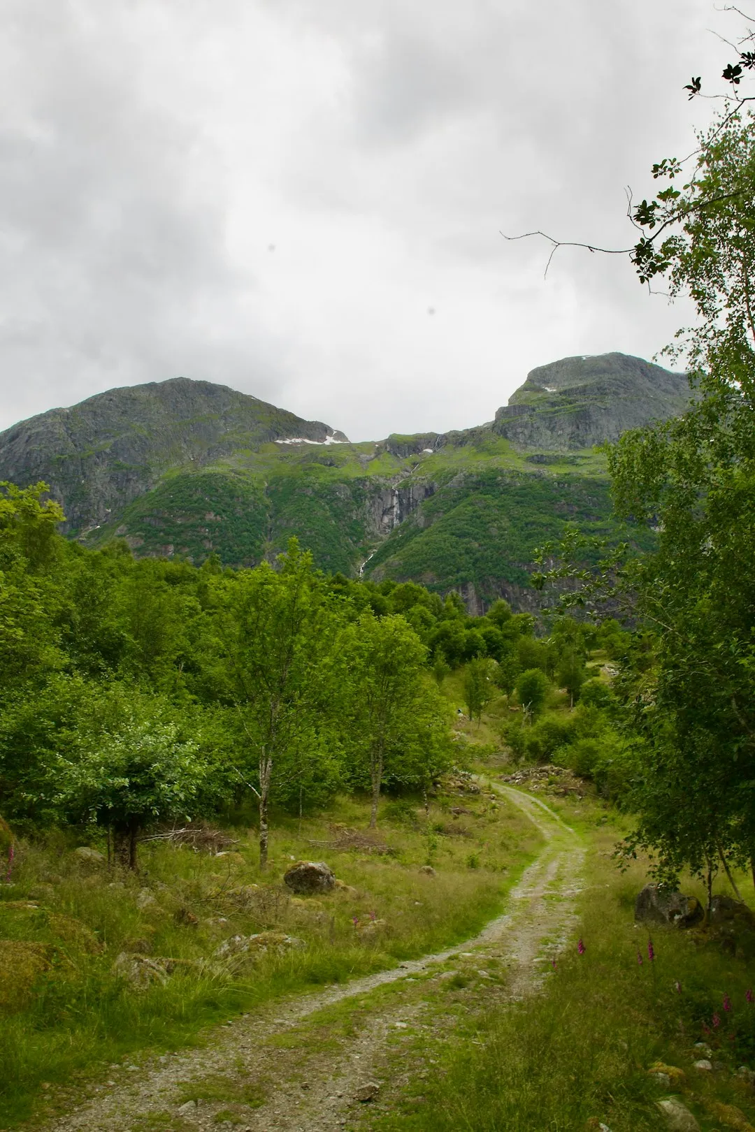
The Fjallbacka Archipelago Trail is a masterclass in coastal diversity, packing an extraordinary range of environments into a manageable 10-kilometre loop. The journey begins in the quintessential Swedish harbour of Fjällbacka, where red-painted wooden boathouses line the waterfront. From here, the trail immediately challenges the hiker with a steep ascent into the Vetteberget, a massive granite monolith that looms over the village. The geological story of this trail is written in the stone; the Bohus granite, formed nearly 900 million years ago, has been polished smooth by retreating glaciers from the last Ice Age, creating the distinctive rounded "whale-back" formations that characterise the region.
One of the most iconic features of the trail is the Kungsklyftan, a narrow canyon split into the side of the mountain. Named after King Oscar II who visited in 1887, the cleft is famous for the massive boulders wedged precariously between its vertical walls—a sight that served as the filming location for the "Wolf’s Cleft" in the film adaptation of Astrid Lindgren’s Ronja the Robber’s Daughter. Beyond the cleft, the trail transitions from dramatic verticality to the horizontal expanse of the coastal heathlands. Here, the path weaves through patches of heather, juniper bushes, and resilient wildflowers that cling to the thin soil between the rocks.
The trail is meticulously marked, yet it retains a wild character. Hikers must navigate natural stone staircases, wooden boardwalks over boggy patches, and open granite plateaus where the "path" is simply a series of painted markers on the stone. The elevation gain of 100 metres may seem modest on paper, but the constant undulation and technical footing make this a rewarding physical endeavour. The reward is constant: every turn reveals a new perspective of the archipelago, from the inner sheltered islands to the outer, treeless skerries where the North Sea begins in earnest. This trail captures the essence of the Swedish west coast—a place where the land and sea are in a constant, beautiful struggle.
History and Cultural Context
The history of the Fjallbacka Archipelago Trail is inextricably linked to the sea and the stone. For centuries, Fjällbacka was a humble fishing village, its fortunes rising and falling with the "herring periods"—massive cyclical migrations of fish that brought sudden wealth to the region. During the great herring boom of the 18th and 19th centuries, the village transformed into a bustling industrial hub for fish processing and oil production. Walking the trail today, one can still see the remnants of this maritime heritage in the architecture of the harbour and the stories of the families who have lived here for generations.
In the late 19th century, the region found a new industry: stone masonry. The very granite that hikers walk upon was once a highly sought-after export. Swedish stonemasons were world-renowned, and Bohus granite was shipped across the globe to pave the streets of Berlin, London, and Paris. The trail passes near old quarry sites where the marks of chisels and drills are still visible in the rock faces, serving as a silent monument to the back-breaking labour of the "stenhuggare" (stone cutters) who shaped the modern world from these cliffs.
In the 20th century, Fjällbacka gained international recognition through its association with Ingrid Bergman. The three-time Academy Award winner spent almost every summer from 1958 until her death in 1982 on the nearby island of Dannholmen. She was a frequent sight in the village, often seen shopping for groceries or walking the local paths. A statue of her now stands in the square that bears her name, overlooking the harbour where the trail begins. More recently, the trail has become a pilgrimage site for fans of "Nordic Noir." Camilla Läckberg, one of Sweden’s most successful crime novelists, was born here and set her Fjällbacka Murders series in the village. The trail often features in her descriptions, with the dark, brooding atmosphere of the Kungsklyftan providing the perfect backdrop for her atmospheric mysteries. This blend of ancient geology, industrial grit, and modern celebrity culture gives the trail a depth that few other coastal walks can match.
Want more background? Read extended notes on history and cultural context → Learn more
Seasonal Highlights and Weather Reality
The Fjallbacka Archipelago Trail is a seasonal chameleon, offering vastly different experiences depending on the time of year. The peak season runs from late May to early September, coinciding with the Swedish summer. During this period, the region enjoys the "Midnight Sun" effect—while not as pronounced as in the Arctic Circle, the twilight lingers until nearly midnight in June, allowing for incredibly long hiking days. The weather is generally mild, with temperatures ranging from 15°C to 25°C, though the coastal breeze can make it feel cooler.
Spring (May and early June) is perhaps the most beautiful time to visit. The coastal flora is in full bloom, with sea pinks (Armeria maritima) carpeting the crevices in the granite and the air filled with the calls of returning migratory seabirds. The trail is less crowded than in the height of summer, and the clarity of the air provides exceptional views of the distant Weather Islands. However, spring can also bring "sea mist"—a thick fog that rolls in from the Skagerrak, reducing visibility to a few metres and making the granite rocks dangerously slippery.
Autumn (September and October) brings a dramatic shift in colour and atmosphere. The heather turns a deep purple, and the deciduous trees in the sheltered valleys transition to vibrant oranges and reds. This is also the start of the lobster season (late September), a major cultural event in Bohuslän. The weather becomes more unpredictable, with frequent Atlantic depressions bringing strong winds and heavy rain. For the experienced hiker, the sight of a storm-tossed North Sea crashing against the granite cliffs is a spectacle of raw power, but it requires high-quality waterproof gear and careful footwork.
Winter (November to April) transforms the trail into a harsh, icy environment. While the archipelago rarely sees deep snow due to the salt air, the granite becomes coated in "black ice," making the steep sections of Vetteberget and the Kungsklyftan extremely hazardous. Most local facilities in Fjällbacka close during the winter months, and the short daylight hours (only 6 hours of light in December) limit hiking opportunities. Only those with experience in icy coastal conditions and proper traction devices (crampons or micro-spikes) should attempt the trail in winter.
Recommended Itinerary
Fjallbacka Archipelago Trail Day Hike
Early Morning: Harbour Start and Village Immersion
- Start at Ingrid Bergmans Torg (Ingrid Bergman Square) in Fjällbacka harbour.
- Spend 30 minutes exploring the waterfront and the historic "Sälsholmen" boathouses.
- Fill water bottles at the public facilities near the tourist information centre.
- Follow the signs marked "Kungsklyftan/Vetteberget" leading away from the water towards the base of the cliffs.
- The trail begins with a series of well-maintained wooden stairs that quickly elevate you above the rooftops.
Mid-Morning: The Ascent and Kungsklyftan
- Enter the Kungsklyftan (The King’s Cleft). This is a 200-metre long passage between vertical granite walls.
- Navigate the uneven floor of the cleft; be mindful of the massive boulders wedged overhead.
- Exit the cleft and follow the blue-marked trail as it zigzags up the southern face of Vetteberget.
- Reach the summit plateau (74 metres). This is the highest point of the trail and offers a 360-degree view of the archipelago.
- Locate the large stone cairns (kummel) which have served as navigational markers for sailors for centuries.
- Distance covered: 2.5 km.
Midday: The Coastal Plateau and Northern Loop
- Continue north across the granite plateau, following the painted blue circles on the rock.
- The terrain here is open and windswept; the path winds through small valleys filled with dwarf birch and juniper.
- Pass through the "Stenhuggarstigen" (Stone Mason’s Path) section, where you can see evidence of historical quarrying.
- Find a sheltered spot among the rocks for a traditional Swedish "fika" (coffee and snack break) while overlooking the sea.
- The trail descends gradually towards the northern outskirts of the village, passing through a small forested area.
- Distance covered: 6.0 km.
Afternoon: Shoreline Return and Galärbacken
- The trail meets the coastline north of the village. Follow the shoreline path heading south.
- Pass by small, secluded swimming coves—perfect for a quick dip in the refreshing Skagerrak if the weather permits.
- Ascend Galärbacken, a small hill with historical significance related to the Swedish navy’s galley ships.
- The path winds back into the village through narrow alleys lined with traditional 19th-century captain’s houses.
- Finish the loop back at the harbour.
- Total distance: 10.0 km.
- Celebrate the completion of the trail with a fresh shrimp sandwich (räksmörgås) at one of the harbour-side cafés.
Important Notes:
- The trail is a loop, but it can be walked in either direction; clockwise is recommended for the best views.
- The Kungsklyftan section can be very slippery after rain; use the handrails where provided.
- There are no toilets or water points once you leave the village area.
- Mobile phone reception is excellent throughout the trail.
- The granite can be very reflective; high-quality sunglasses are essential even on overcast days.
Planning and Bookings
Book Your Trip
Everything you need to plan your journey
Accommodation
Find places to stay near Gothenburg
Flights
Search flights to Gothenburg
Essential Preparation
The Fjallbacka Archipelago Trail is a moderate hike that requires a reasonable level of fitness, primarily due to the steep stairs and the uneven, rocky nature of the granite plateaus. While the distance is short, the terrain is "technical" in places, meaning you will be stepping over cracks, navigating boulders, and climbing steep gradients. Preparation should focus on footwear and weather readiness. There is no need to book the trail itself, as it is open to the public year-round.
Logistically, Gothenburg (Göteborg) is the primary gateway. From Gothenburg Landvetter Airport (GOT), you can take the Flygbussarna shuttle to the city centre. From the Nils Ericson Terminal, Bus 841 (operated by Västtrafik) runs directly to Fjällbacka, taking approximately 2.5 hours. If driving, the E6 motorway north from Gothenburg is a fast, well-maintained route; take the exit for Tanumshede/Fjällbacka. Parking in Fjällbacka can be extremely difficult during July; it is recommended to use the long-term parking lots on the outskirts of the village and walk the 10 minutes to the harbour.
Trail Accommodation
As the Fjallbacka Archipelago Trail is a 10-kilometre loop, it is typically completed as a day hike. There are no huts or campsites directly on the trail route. However, Fjällbacka and the surrounding Tanum Municipality offer a variety of accommodation options for those wishing to stay overnight.
Accommodation Options:
- Stora Hotellet Bryggan: A historic, high-end hotel located directly on the harbour. It offers themed rooms and excellent dining.
- Fjällbacka Backpackers: A more budget-friendly hostel option located within walking distance of the trailhead.
- Badholmens Vandrarhem: A unique hostel located on a small island in the harbour, accessible by a short bridge.
- Camping: The nearest official campsite is Fjällbacka Camping, located about 2 kilometres from the village centre. It offers spots for tents, caravans, and small cabins.
Booking Requirements:
- During the peak months of July and August, accommodation in Fjällbacka must be booked several months in advance.
- Outside of the summer season, availability is much higher, though some smaller guesthouses may close for the winter.
- Costs vary significantly: Hostels start around 400 SEK per night, while hotels can exceed 2,500 SEK during peak season.
Required Gear
- Hiking Boots or Shoes: Essential. You need footwear with excellent grip (Vibram soles or similar) to handle the smooth granite, which becomes like ice when wet. Ankle support is recommended for the uneven sections.
- Windproof Jacket: The archipelago is notoriously windy. A lightweight, breathable windbreaker or hardshell is necessary even in summer.
- Layered Clothing: Use the "three-layer principle." A moisture-wicking base layer (merino wool or synthetic), an insulating mid-layer (fleece), and a protective outer shell.
- Sun Protection: The sun reflects intensely off the granite and the water. Bring a hat, high-SPF sunscreen, and polarised sunglasses.
- Small Daypack: A 15–25 litre pack is sufficient for this distance.
- First Aid Kit: Include blister plasters (Compeed), antiseptic wipes, and basic bandages. The granite can be abrasive if you slip.
What to Bring
- Water: Bring at least 1.5 litres per person. There are no natural springs or taps on the trail once you leave the village.
- Fika Supplies: Hiking in Sweden is incomplete without "fika." Bring a thermos of coffee or tea and some cinnamon buns (kanelbullar) or fruit.
- Snacks: High-energy snacks like nuts, dried fruit, or chocolate to maintain energy on the steep climbs.
- Map and Compass: While the trail is well-marked with blue paint, a physical map or a downloaded offline map (such as AllTrails or Naturkartan) is a vital backup.
- Power Bank: To ensure your phone remains charged for navigation and photography.
- Swimwear and Lightweight Towel: If hiking in summer, the coastal sections offer tempting opportunities for a swim in the sea.
- Trash Bag: To carry out all your waste, including organic matter like fruit peels.
Permits
One of the greatest joys of hiking in Sweden is the lack of bureaucratic hurdles. No permits, fees, or registrations are required to walk the Fjallbacka Archipelago Trail. This freedom is granted by Allemansrätten, or the "Right of Public Access," a unique constitutional right that allows everyone to roam freely in the Swedish countryside, provided they follow the principle of "do not disturb, do not destroy."
Understanding Allemansrätten on the Trail:
- Access: You are permitted to walk on the trail, even where it passes through what might appear to be private land, as long as you stay away from the "hemfridszon" (the immediate area around a private dwelling).
- Camping: While Allemansrätten generally allows for one night of wild camping, this is restricted in many parts of the Fjällbacka archipelago due to its status as a nature conservation area. Camping is not permitted on Vetteberget or within the village limits. Use the official campsite nearby.
- Fires: Making open fires on the granite rocks is strictly prohibited. The heat causes the ancient stone to crack and shatter, causing irreparable geological damage. Use a portable camping stove if necessary, but only in designated areas.
- Foraging: You are allowed to pick wild berries and mushrooms, but you must not pick protected wildflowers or damage trees and shrubs.
Local Regulations: While no permit is needed for the hike, if you plan to engage in other activities like recreational fishing in the sea, no license is required for hand-held gear. However, there are strict rules regarding the size and quantity of certain species, particularly lobster and trout. Always check the current regulations at the local tourist office if you plan to do more than just hike.
Other Activities in the Area
Fjällbacka is a hub for coastal adventure. Consider these activities to complement your hike:
- Väderöarna (The Weather Islands) Boat Trip: Take a 35-minute boat ride to Sweden's most westerly island group. These islands offer world-class birdwatching, a unique microclimate, and some of the best seafood in the country. The boat departs regularly from the Fjällbacka harbour.
- Sea Kayaking: The sheltered inner archipelago is a paradise for paddlers. Several outfitters in the village offer kayak rentals and guided tours. Paddling through the narrow channels between the islands provides a completely different perspective of the granite cliffs you just hiked.
- Seafood Safaris: Join a local fisherman on a "Lobster Safari" (in autumn) or a "Crayfish Safari" (in summer). You’ll help haul the traps and learn about the sustainable fishing practices of the Bohuslän coast, usually followed by a traditional seafood feast.
- Vitlycke Museum and Tanum Rock Carvings: Located just 15 minutes inland by car, this UNESCO World Heritage site features thousands of Bronze Age rock carvings (petroglyphs). It is one of the most important archaeological sites in Europe and provides a fascinating look at the people who lived on this coast 3,000 years ago.
- Island Hopping: Use the local ferry system to visit nearby islands like Hamburgö, which is just a few minutes away by a free cable ferry and offers its own set of beautiful walking paths and swimming spots.
Safety and Conditions
Pre-Departure Checks:
- Check the local forecast on SMHI (Swedish Meteorological and Hydrological Institute). Pay close attention to wind speeds and "sea smoke" (fog) warnings.
- Ensure your footwear is in good condition; the granite terrain is unforgiving on worn-out soles.
- Inform someone of your intended route and expected return time, even though the trail is close to the village.
- Check for any local "Naturvårdsverket" (Environmental Protection Agency) alerts regarding trail maintenance or temporary closures.
Terrain Hazards: The primary danger on the Fjallbacka Archipelago Trail is the granite itself. When dry, the stone provides excellent friction. However, when wet—even from light drizzle or sea spray—it becomes incredibly slick. The Kungsklyftan section involves navigating large, uneven stones where a fall could result in a sprained ankle or worse. The summit of Vetteberget is an open plateau with no railings; in high winds, stay well back from the cliff edges. The wooden stairs can also become slippery with algae or frost; always use the handrails.
Weather Volatility: The weather on the Swedish west coast can change with startling speed. A sunny morning can transform into a gale-force storm within an hour. Hypothermia is a genuine risk, even in summer, if you get wet and are exposed to the constant coastal wind. Always carry a waterproof layer, regardless of the forecast.
Ticks and Lyme Disease: Like much of coastal Sweden, the tall grasses and heather along the trail are home to ticks (fästingar). Some ticks in this region carry Lyme disease or TBE (Tick-borne encephalitis). Wear long trousers when walking through vegetation, use insect repellent, and perform a thorough "tick check" on your body after the hike.
Emergency Services: In the event of a serious accident, the emergency number in Sweden is 112. Because the trail is close to the village, mountain rescue is generally not required, but the local ambulance or sea rescue (Sjöräddningssällskapet) can be dispatched if needed. Mobile coverage is excellent, but remember that cold temperatures can drain phone batteries quickly.
Side Trips and Points of Interest
Kungsklyftan (The King’s Cleft): This is the undisputed highlight of the trail. The cleft was formed by a tectonic fault that was later widened by glacial meltwater. As you walk through, look up to see the "hanging boulders"—massive rocks that fell during the post-glacial period and became wedged between the narrow walls. The atmosphere inside is cool and damp, even on the hottest summer days, with mosses and ferns thriving in the permanent shade. It is a place of profound geological power and cinematic history.
Vetteberget Summit: The plateau at the top of Vetteberget is more than just a viewpoint; it is a historical site. For centuries, this was the location of a "vårdkase"—a signal fire that was lit to warn the population of approaching enemy ships. Today, the summit is marked by several large Bronze Age stone cairns. The view from the top encompasses the entire Fjällbacka archipelago, and on a clear day, you can see the lighthouse on the Weather Islands, nearly 15 kilometres out to sea.
Galärbacken (The Galley Hill): Located on the southern loop of the trail, this hill offers a quieter, more reflective viewpoint. It is named after the galleys (warships) that were stationed here during the 18th-century wars between Sweden and Denmark-Norway. The hill provides a perfect vantage point to watch the boats navigating the narrow "Fjällbackafjorden" and to appreciate the strategic importance of this sheltered harbour.
The Stone Mason’s Path: On the northern section of the trail, you will pass through areas where the granite has been clearly worked by human hands. Look for the "plug and feather" marks—rows of small holes where masons inserted wedges to split the stone. These sites are a poignant reminder of the industry that once dominated the coast and the thousands of men who spent their lives shaping the very ground you are walking on.
Sälsholmen: While technically at the start/end of the trail in the harbour, this cluster of historic boathouses is a must-see. Many of these structures date back to the 19th century and are still used by local fishermen. The contrast between the weathered grey wood, the bright red Falu paint, and the pink granite cliffs behind them is the quintessential image of Bohuslän.
Leave No Trace
The Fjallbacka Archipelago Trail passes through a landscape that is both ancient and fragile. The thin soil on the granite plateaus takes centuries to accumulate, and the specialised plants that grow here are easily damaged. As a hiker, you are a guest in this ecosystem, and it is your responsibility to ensure that your presence leaves no lasting impact.
Principles for the Archipelago:
- Stick to the Stone: When walking on the plateaus, try to stay on the bare granite rather than stepping on patches of moss or heather. The granite is indestructible; the vegetation is not.
- Waste Management: There are no bins on the trail. Pack out every piece of litter, including "biodegradable" items like orange peels or banana skins, which decompose very slowly in the cool, salty coastal air.
- Protect the Geology: Never move stones to build new cairns. The existing cairns are often historical markers or navigational aids; adding to them or creating new ones confuses other hikers and disturbs the natural aesthetic.
- Respect the Wildlife: The archipelago is a vital breeding ground for seabirds. During the nesting season (April to July), stay on the marked trails and keep noise to a minimum. If you see a bird acting distressed, you are likely too close to a nest; move away quietly.
- Sanitation: Use the public toilets in the village before you start. If you are caught short on the trail, ensure you are at least 50 metres from any water source or path, and bury all human waste and toilet paper deeply. Better yet, carry a "wag bag" and pack it out.
- No Fires: As mentioned, never build a fire on the granite. The scars left by cracked stone last for millennia.
By following these principles, you help preserve the "wild" feeling of the Fjallbacka Archipelago Trail for the next generation of explorers. The goal is to leave the trail exactly as you found it—or better.