Argentina — El Chalten
Circumnavigate South America's premier alpine landscape on the Fitz Roy Trek in Argentina. This demanding 55km, 4-day route through Los Glaciares National Park offers unparalleled panoramas of iconic granite spires. Starting and ending in El Chaltén, the "Hiking Capital," this challenging traverse winds through glacial valleys and across rugged ridges, showcasing pristine wilderness and breathtaking mountain views.
Distance: 55.0 km
Elevation Gain: 1100 m
Difficulty: Challenging
Duration: 4 days
The Fitz Roy Trek, often referred to as the "Mount Fitz Roy Loop" or the "Chaltén Traverse," is South America’s premier alpine hiking experience. Located within the northern sector of Los Glaciares National Park in Argentina’s Santa Cruz Province, this 55-kilometre journey circumnavigates the most iconic granite spires on Earth. Unlike many remote wilderness treks, this route begins and ends in the charming mountain village of El Chaltén, the self-proclaimed "Hiking Capital of Argentina." The trek weaves through ancient southern beech forests, crosses glacial meltwater streams of impossible clarity, and climbs to high-altitude viewpoints where the sheer vertical walls of Monte Fitz Roy (3,405 metres) and Cerro Torre (3,128 metres) dominate the skyline. This is a landscape of extremes, where the South Patagonian Ice Field breathes cold air across the Andes, creating a microclimate famous for its ferocious winds and rapidly shifting weather. For hikers, it offers a rare combination of accessible trailheads and world-class rugged beauty, making it a mandatory pilgrimage for those seeking the raw essence of Patagonia.
The Fitz Roy Trek is a masterclass in geological drama. While the total elevation gain of 1,100 metres might seem modest over four days, the statistics belies the physical reality of the terrain. The route is defined by "Patagonian flats"—long stretches of undulating forest trails—interrupted by brutally steep, rocky climbs that ascend directly up glacial moraines. The most famous of these is the final kilometre to Laguna de los Tres, which gains 400 metres of elevation in a single, lung-bursting push over loose scree and granite boulders. However, the reward is arguably the most famous view in the Southern Hemisphere: the three-pronged granite massif of Fitz Roy rising vertically above a turquoise glacial lake.
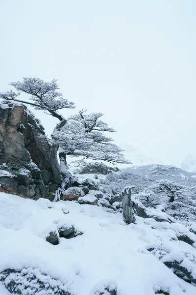
The trek is unique because it transitions through several distinct ecological zones. You begin in the arid Patagonian steppe, where the wind-whipped grasses transition into dense forests of Lenga (Nothofagus pumilio) and Ñire (Nothofagus antarctica). These trees, stunted and twisted by the relentless prevailing westerlies, create a "goblin forest" atmosphere, draped in "old man’s beard" lichen. As you climb higher, the forest thins, giving way to high alpine tundra and eventually the raw, exposed rock and ice of the glacial basins. The presence of the South Patagonian Ice Field—the world's third-largest continental ice mass—is felt everywhere, from the icebergs floating in Laguna Torre to the permanent glaciers clinging to the mountain flanks.
What sets the Fitz Roy Trek apart from its Chilean counterpart, the "W" Trek in Torres del Paine, is its sense of freedom. There are no mandatory booking systems for campsites, no high fees for entry (currently), and the trails are managed with a philosophy of minimal intervention. This allows for a more spontaneous experience, though it requires hikers to be more self-sufficient. The proximity to El Chaltén means you can tailor the trek to your fitness level, but to truly experience the magic of the "Golden Hour"—when the granite peaks turn a fiery orange at sunrise—spending nights in the wilderness camps is essential. This is a journey into the heart of a landscape that has inspired explorers, climbers, and dreamers for centuries.
The human history of the Fitz Roy region is as layered as the sedimentary rock found in its valleys. For thousands of years, the area was the ancestral home of the Aonikenk people, also known as the Tehuelche. They were nomadic hunter-gatherers who followed the seasonal migrations of guanacos across the steppe. To the Aonikenk, the massive peak we now call Fitz Roy was known as "Chaltén," which translates to "smoking mountain." This name was not a reference to volcanic activity—the mountain is granite, not volcanic—but rather to the near-constant cap of clouds that clings to its summit, resembling a plume of smoke. The mountain held deep spiritual significance, appearing in Tehuelche mythology as a sacred pillar of the world.
European contact began in the 19th century. In 1877, the Argentine explorer Francisco "Perito" Moreno reached the shores of Lake Viedma. He renamed the peak "Mount Fitz Roy" in honour of Robert FitzRoy, the captain of the HMS Beagle who had surveyed the Patagonian coast decades earlier (and who famously travelled with Charles Darwin). Moreno chose to honour FitzRoy despite the captain never having seen the mountain, a decision that remains a point of historical debate today, as the local community has reclaimed the name "El Chaltén" for the town and the mountain's traditional identity.
The 20th century saw the region become a global focal point for extreme mountaineering. The sheer granite walls were considered "impossible" until the post-WWII era. In 1952, French climbers Lionel Terray and Guido Magnone completed the first ascent of Fitz Roy, a feat that remains one of the most respected achievements in climbing history. Later, in 1970, the controversial "Compressor Route" on Cerro Torre by Cesare Maestri sparked a decades-long debate about climbing ethics and the use of permanent bolts. Today, El Chaltén is a vibrant hub where the ghosts of legendary climbers mingle with modern trekkers. The town itself was only founded in 1985, making it one of Argentina's youngest settlements, established primarily to secure the border during a territorial dispute with Chile. Since then, it has evolved from a remote military outpost into a world-class trekking destination, all while maintaining a fierce commitment to environmental preservation and its rugged, frontier spirit.
Want more background? Read extended notes on history and cultural context → Learn more
Patagonia does not have weather; it has "conditions." The region is located in the "Furious Fifties" latitudes, where nothing stands between the Andes and the moisture-laden winds of the Pacific Ocean. Consequently, weather can cycle through all four seasons in a single hour. Understanding the seasonal nuances is critical for a successful trek.
Summer (December to February): This is the peak trekking season. Days are long, with daylight lasting until 10:00 PM, providing ample time for long distances. Temperatures are mild, ranging from 10°C to 20°C during the day, though they can drop to near freezing at night. However, this is also the windiest season. Gusts exceeding 100 km/h are common, capable of flattening tents and making high-altitude passes dangerous. This is when the trails are busiest, and campsites like Poincenot can feel crowded.
Autumn (March to April): Many experienced hikers consider this the "Golden Season." The wind begins to die down, and the Lenga forests turn a spectacular palette of deep reds, oranges, and golds. The air is crisp and clear, often providing the best visibility for the peaks. While nights are colder and there is a higher chance of early snow, the lack of crowds and the stunning colours make it a photographer’s dream. By late April, many services in El Chaltén begin to close for the winter.
Spring (October to November): The landscape wakes up in a burst of green, and wildflowers like the red Notro (firebush) begin to bloom. The weather is highly unpredictable, with frequent rain and lingering snow on the higher trails. However, the mountains are at their most dramatic, heavily laden with winter ice and snow. This is a great time for those seeking solitude before the summer rush.
Winter (May to September): The Fitz Roy Trek becomes a serious winter expedition. Most trails are buried in snow, and daylight is scarce. Temperatures frequently drop to -15°C. Only experienced winter hikers with snowshoes or crampons and high-quality four-season gear should attempt the route. Many trail markers are obscured, and the town of El Chaltén enters a deep hibernation with very few shops or hostels remaining open.
Day 1: El Chaltén to Campamento Poincenot
Day 2: Laguna de los Tres and Piedras Blancas Glacier
Day 3: Campamento Poincenot to Campamento De Agostini (via Lagunas Madre y Hija)
Day 4: Laguna Torre to El Chaltén
Important Notes:
The Fitz Roy Trek is unique among world-class multi-day hikes because it requires very little advance booking, but significant logistical preparation. Your primary base will be El Chaltén. You should plan to arrive in town at least one day before your trek to check weather forecasts, rent any missing gear, and register with the National Park office. Physical fitness is important; while much of the trail is moderate, the steep climbs to viewpoints require good cardiovascular health and stable knees for the descents.
Logistically, you will likely fly into El Calafate (FTE). From there, regular buses run the 215-kilometre route to El Chaltén (approximately 3 hours). It is wise to book your bus tickets a few days in advance during the peak months of January and February. El Chaltén has several supermarkets, but selection can be limited and prices are higher than in larger cities. If you have specific dietary requirements or high-end dehydrated meals, buy them in Buenos Aires or El Calafate before arriving.
Accommodation on the Fitz Roy Trek consists of designated wilderness campsites managed by Los Glaciares National Park (APN). Unlike the Chilean parks, these are currently free of charge and do not require reservations.
Campsite Facilities:
What is NOT Provided:
Note on El Chaltén: For the nights before and after your trek, El Chaltén offers a wide range of accommodation from luxury hotels to budget hostels. During peak season (January), these book out months in advance.
As of the current season, there is no fee to enter the northern sector of Los Glaciares National Park for trekking, and no specific "permit" is required to hike the Fitz Roy Trek. This makes it one of the most accessible world-class treks in existence. However, there are several administrative and regulatory steps you must follow to ensure the park remains protected and you remain safe.
Registration and Regulations:
Future Changes: There have been ongoing discussions by the Argentine government regarding the implementation of an entry fee for the El Chaltén sector, similar to the fee charged at the Perito Moreno Glacier. Always check the official APN website or the visitor centre upon arrival for the most up-to-date information regarding fees or new permit requirements.


Precisely traced GPX for the Fitz Roy Trek, ready for your GPS or favourite mapping app.
El Chaltén is a paradise for outdoor enthusiasts, and many visitors stay for a week or more to explore the surrounding wilderness:
The Patagonian Wind: The single greatest safety hazard in the Fitz Roy region is the wind. It is not uncommon for gusts to reach 120 km/h. These winds can cause "whiteout" conditions by blowing dust or snow, and they can make walking on exposed ridges dangerous. If the wind is too strong, stay in the forested areas and avoid high viewpoints like Laguna de los Tres.
Water Safety: While the glacial meltwater is generally pristine, the increase in trekking numbers has led to concerns about water-borne parasites near campsites. Always collect water upstream from camps and use a filter or purification tablets. Never wash dishes or yourself directly in the streams; carry water at least 20 metres away from the source.
Navigation: The main trails are well-marked with yellow and white stakes and wooden signs. However, in bad weather or snow, visibility can drop to a few metres. Always carry an offline map (such as Maps.me or Gaia GPS) and a physical map. If you lose the trail, do not wander; backtrack to the last known marker.
Hypothermia: Even in mid-summer, the combination of rain, wind, and cold temperatures can lead to hypothermia. Always carry your waterproof layers, even on a sunny day. Avoid cotton clothing, which loses all insulating properties when wet; stick to wool or synthetic materials.
Emergency Services: There is a small medical clinic in El Chaltén for minor injuries. For serious emergencies, the nearest major hospital is in El Calafate. Search and rescue (SAR) is coordinated by the National Park rangers and the Comisión de Auxilio (volunteer rescue team). Be aware that rescues can be delayed for days by bad weather. Carrying a Satellite Messenger (like a Garmin inReach) is highly recommended for solo hikers.
Loma del Pliegue Tumbado: Often overlooked, this is arguably the best viewpoint in the park. It is a separate day hike (or an extension) that climbs to a 1,500-metre ridge. From the summit, you can see both the Fitz Roy massif and the Cerro Torre massif simultaneously, along with a vast expanse of Lake Viedma. It provides a unique "top-down" perspective on the glacial valleys.
Piedra del Fraile: Located on private land just outside the park boundary (a small fee is required), this area offers a different angle of the north face of Fitz Roy. It was the base camp for many early expeditions and offers a more rugged, less-travelled experience.
Chorrillo del Salto: An easy 3 km walk from town leads to this beautiful 20-metre waterfall. It’s a perfect "rest day" activity or a short walk if you arrive in town late in the afternoon.
Mirador Maestri: For those staying at Campamento De Agostini, this 2 km trail follows the ridge above Laguna Torre. It is named after the climber Cesare Maestri and offers a spectacular view of the Glaciar Torre and the "Ice Mushroom" that often forms on the summit of Cerro Torre.
Los Glaciares National Park is a fragile ecosystem under increasing pressure from global tourism. The "Leave No Trace" principles are not just suggestions; they are essential for the survival of this wilderness. The soil is thin, and the vegetation grows incredibly slowly due to the harsh climate. A single footstep off-trail can destroy plants that took years to grow.
Key Principles for Fitz Roy: