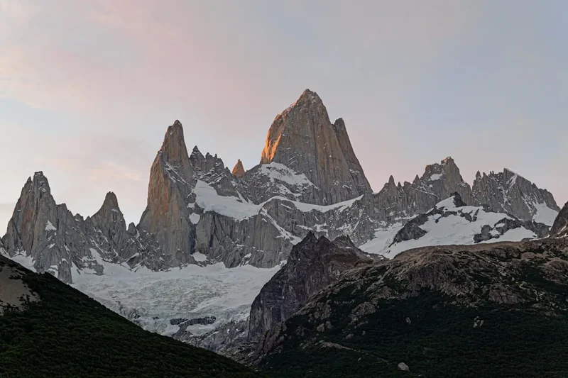
Fitz Roy Laguna de los Tres - The Crown Jewel of Patagonia
The trek to Laguna de los Tres is arguably the most iconic day hike in South America, a 21.4-kilometre pilgrimage to the base of the legendary Mount Fitz Roy. Located in the northern sector of Los Glaciares National Park in Argentina, this trail offers a sensory overload of Patagonian grandeur. The journey takes hikers through ancient southern beech forests, across crystal-clear glacial streams, and up a punishing final ascent to reach a turquoise lagoon perched directly beneath the sheer granite walls of the Fitz Roy massif. Standing at 3,405 metres, the jagged silhouette of Cerro Chaltén (the indigenous name for Fitz Roy) dominates the skyline, often shrouded in a crown of lenticular clouds that gave rise to the myth that the mountain was a volcano.
This is a challenging trek that demands physical stamina and mental fortitude, particularly during the final kilometre where the trail gains 400 metres of elevation over a steep, rocky moraine. However, the reward is a panoramic view that has graced the covers of countless mountaineering journals and travel magazines. It is a landscape defined by the raw power of ice and wind, where the Southern Patagonian Ice Field—the world's third-largest continental ice mass—exerts its influence on every gust of air and every drop of water. For many, this hike is the primary reason for visiting El Chaltén, the "Hiking Capital of Argentina," and it remains a bucket-list experience for trekkers from across the globe.
- Distance: 21.4 km (round trip from El Chaltén or point-to-point from El Pilar)
- Duration: 8–10 hours
- Season: October–April (Peak season January and February)
- Highest point: Laguna de los Tres (1,170 m)
- Elevation Gain: 1,200 m total cumulative gain
- Difficulty: Challenging (due to the final steep ascent and total distance)
- Trailhead: El Chaltén (Avenida San Martín) or Hostería El Pilar
Overview
The Laguna de los Tres trail is a masterclass in Patagonian geography. While many hikers choose to start and end their journey in the village of El Chaltén, a popular and highly recommended variation is to begin at the Hostería El Pilar (accessible by a short shuttle bus or taxi) and walk back to town. This point-to-point route ensures you never see the same scenery twice and includes a spectacular view of the Piedras Blancas Glacier, a hanging glacier that spills down the eastern flanks of the Fitz Roy range. The path is exceptionally well-marked, maintained by the Administración de Parques Nacionales (APN), and requires no technical climbing skills, though trekking poles are highly recommended for the descent.
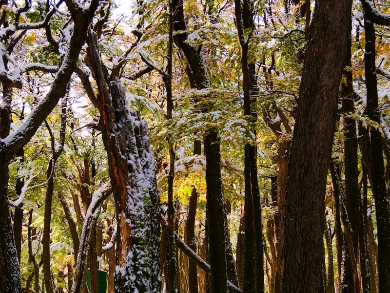
The first two-thirds of the hike are deceptively gentle. From the El Pilar trailhead, the path meanders through dense forests of Lenga (Nothofagus pumilio) and Ñire (Nothofagus antarctica) trees. These deciduous beeches turn a fiery palette of red and orange in late April, creating a stark contrast against the granite spires. The trail follows the Blanco River, where the water is so pure it can be drunk directly from the source. As you progress, the forest occasionally opens up to reveal the massive granite teeth of the massif: Fitz Roy, Poincenot, Saint-Exupéry, Mermoz, and Guillaumet. Each peak has its own storied history in the annals of alpine climbing, and seeing them from the valley floor provides a humbling sense of scale.
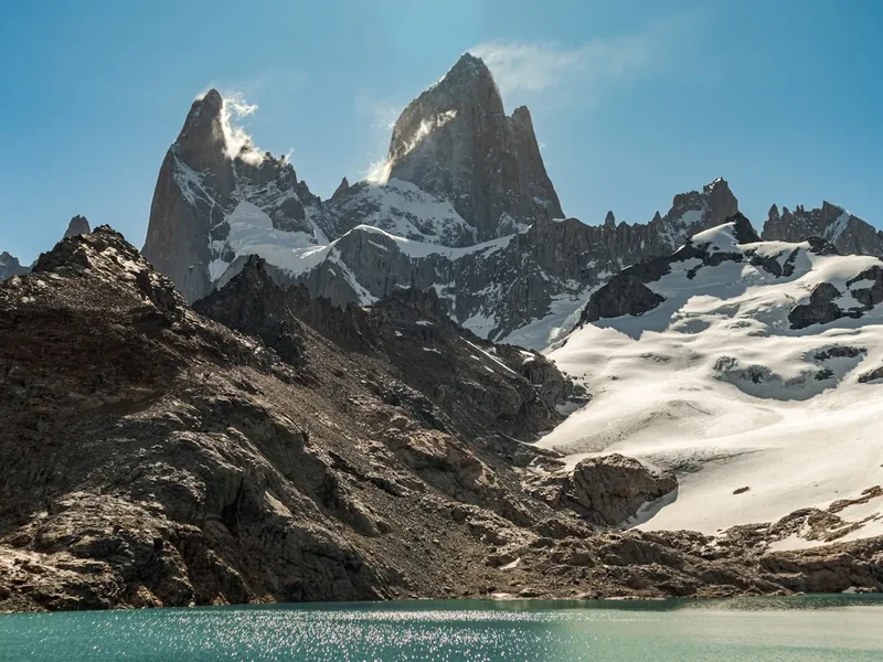
The character of the hike changes abruptly at Campamento Poincenot, the base camp for many multi-day trekkers. From here, the trail crosses a small bridge and begins the "Final Kilometre." This section is a relentless scramble up a steep moraine composed of loose scree and large boulders. It is a test of cardiovascular fitness and patience, as the summit often feels tantalisingly close yet remains hidden behind the next ridge. Upon reaching the crest, the view explodes into life: the cobalt-blue Laguna de los Tres sits in the foreground, backed by the vertical walls of Fitz Roy. To the left, a short scramble over a secondary ridge reveals the hidden Laguna Sucia (Dirty Lagoon), which, despite its name, is a stunning emerald pool fed by hanging glaciers and waterfalls. The descent follows the same steep path before branching off towards El Chaltén, passing the beautiful Laguna Capri and several viewpoints overlooking the Las Vueltas River valley.
History and Cultural Context
The mountains of the Fitz Roy massif have held deep spiritual significance for the indigenous Tehuelche people for centuries. They called the highest peak "Chaltén," which translates to "smoking mountain" in the Aonikenk language. This name refers to the near-constant clouds that cling to the summit, which the Tehuelche believed was smoke from a volcanic vent. To the indigenous inhabitants, the mountain was a sacred landmark, a fixed point in a nomadic landscape of vast steppes and shifting glaciers.
The European name "Fitz Roy" was bestowed upon the mountain in 1877 by the Argentine explorer Francisco "Perito" Moreno. He named it in honour of Robert FitzRoy, the captain of the HMS Beagle, who had surveyed the Patagonian coast in the 1830s (accompanied by a young Charles Darwin). Interestingly, FitzRoy himself never saw the mountain that bears his name, as his surveys were confined to the coastal waters and the Santa Cruz River. The naming was part of a broader effort by the Argentine government to map and claim the interior of Patagonia during a period of intense border disputes with Chile.
The mountaineering history of the region is equally legendary. The first successful ascent of Mount Fitz Roy was achieved in 1952 by a French expedition led by Lionel Terray and Guido Magnone. At the time, it was considered one of the greatest feats in technical climbing due to the extreme weather, the verticality of the granite, and the sheer isolation of the peak. Today, the surrounding needles are named after other pioneers and figures of interest, such as the Aiguille Saint-Exupéry (named after the author of The Little Prince, who was a pioneering aviator in Patagonia) and Aguja Poincenot (named after a French climber who drowned in the Rio Fitz Roy during the 1952 expedition). The village of El Chaltén itself is a relatively recent addition to the map; it was founded in 1985 as a strategic outpost to secure the border with Chile, but it quickly evolved into a global hub for trekking and climbing.
Want more background? Read extended notes on history and cultural context → Learn more
Seasonal Highlights and Weather Reality
Patagonia is famous for having "four seasons in one day," and the Laguna de los Tres trail is the ultimate stage for this meteorological theatre. The hiking season officially runs from October to April, but each month offers a distinct experience. The "Roaring Forties"—the powerful westerly winds that circle the globe at this latitude—are a constant factor, often reaching speeds of over 100 kilometres per hour. These winds can make the final ascent to the lagoon particularly challenging and, in extreme cases, dangerous.
Summer (December to February): This is the peak season. Days are long, with daylight lasting until 10:00 PM, providing ample time for the long trek. The weather is generally at its warmest (15–20°C), but this is also when the winds are most ferocious. The trail can become crowded, especially the final steep section, and the village of El Chaltén is often fully booked. This is the best time for those who want the highest probability of clear skies, though Fitz Roy is notorious for hiding in the clouds even on "sunny" days.
Autumn (Late March to April): Many experienced hikers consider this the best time to visit. The winds tend to die down, and the air becomes crisp and clear. The highlight is the spectacular autumn foliage; the Lenga forests turn a deep, vibrant crimson, creating incredible photographic opportunities. Temperatures are cooler (5–12°C), and there is a higher chance of early snowfall at the lagoon, which only adds to the drama of the landscape.
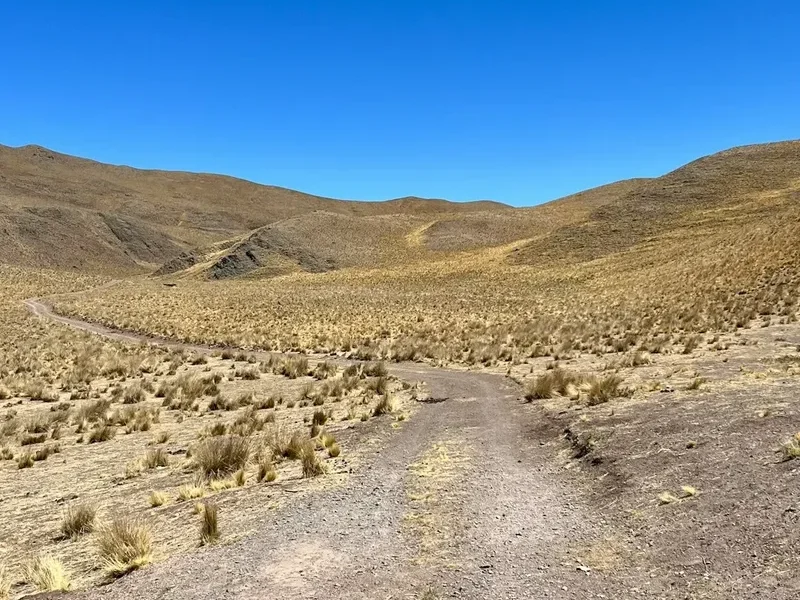
Spring (October to November): The trail begins to wake up from winter. Snow may still block the higher sections of the path, and the lagoon itself is often frozen and covered in white. The weather is highly unpredictable, with frequent rain and wind. However, the wildflowers begin to bloom, and the crowds are significantly thinner than in the summer months.
Winter (May to September): The trail is not officially closed, but it becomes an advanced winter expedition. The final ascent is often covered in deep snow and ice, requiring crampons and ice axes. Most services in El Chaltén shut down, and the days are very short. Only those with significant winter mountain experience and proper gear should attempt the hike during these months.
Recommended Itinerary
Laguna de los Tres Day Hike (El Pilar Variation)
08:00 – 08:45: Transport to El Pilar
- Take a pre-booked shuttle or taxi from El Chaltén to Hostería El Pilar (17 km north of town).
- The drive follows the scenic Rio de las Vueltas valley.
- Drop-off at the trailhead near the Blanco River.
08:45 – 10:30: The Forest Ascent
- Distance: 5 km
- Elevation gain: 200 m
- The trail begins with a steady climb through dense Lenga forest.
- Key Waypoint: Mirador Glaciar Piedras Blancas. A spectacular viewpoint where you can see the hanging glacier and its ice-choked lagoon.
- Listen for the thunderous sound of ice calving off the glacier in the distance.
10:30 – 12:00: The Valley Floor to Poincenot
- Distance: 4 km
- Elevation: Mostly flat
- The trail levels out as it enters the Blanco River valley.
- Pass through open marshlands and beautiful sections of old-growth forest.
- Arrive at Campamento Poincenot, the main backcountry campsite.
- Cross the wooden bridge over the Rio Blanco. This is the last reliable spot to fill water bottles before the summit.
12:00 – 13:30: The Final Kilometre
- Distance: 1 km
- Elevation gain: 400 m
- The most demanding part of the day. A steep, rocky zigzag path up the moraine.
- The trail is well-defined but composed of loose stones; watch your footing.
- Take frequent breaks to look back at the view of the Viedma Lake in the distance.
13:30 – 14:30: Laguna de los Tres and Laguna Sucia
- Arrive at the crest to see Laguna de los Tres and the massive Fitz Roy spires.
- Walk down to the shore of the lagoon (often windy).
- MANDATORY SIDE TRIP: Follow the trail to the left (south) for 5 minutes to the ridge overlooking Laguna Sucia. The emerald water and hanging glaciers are often more impressive than the main lagoon.
- Lunch break and photography.
14:30 – 18:30: Return to El Chaltén via Laguna Capri
- Distance: 11.4 km
- Elevation: 750 m descent
- Descend the steep moraine carefully (trekking poles essential).
- At the junction near Poincenot, follow signs for "El Chaltén via Laguna Capri."
- Pass through the beautiful Laguna Capri, a perfect spot for a final rest by the water.
- The final 4 km offer sweeping views of the town and the river valley before descending steeply into the north end of El Chaltén.
Important Notes:
- Total distance is approximately 21.4 km.
- The "El Pilar" start is highly recommended to avoid repeating the same scenery.
- There are no shops or facilities on the trail; you must be self-sufficient.
- The final ascent can be closed by park rangers in cases of extreme wind.
- Start early (before 8:00 AM) to ensure you have enough daylight and to beat the largest crowds.
Planning and Bookings
Book Your Trip
Everything you need to plan your journey
Accommodation
Find places to stay near El Chalten
Flights
Search flights to El Chalten
Essential Preparation
The primary logistical hub for this hike is the village of El Chaltén. Unlike many other famous treks in Patagonia (such as the W Trek in Torres del Paine), the Laguna de los Tres hike does not require advanced bookings for the trail itself. There are no park entry fees for the northern sector of Los Glaciares National Park (as of 2024), and no permits are required for day hikers. However, the village of El Chaltén is small and can become extremely crowded during the peak months of January and February. It is essential to book your accommodation in town at least 3–4 months in advance for the summer season.
Physical preparation is key. While the first 8 kilometres are moderate, the final 400-metre climb is equivalent to climbing the stairs of a 120-storey building on a shifting, rocky surface. Hikers should have a good level of cardiovascular fitness and be comfortable with long days on their feet. If you are staying in El Calafate, do not attempt this as a day trip from there; the 3-hour bus ride each way leaves insufficient time to complete the hike safely. Plan to stay at least 3 nights in El Chaltén to allow for weather flexibility.
Trail Accommodation
This is primarily a day hike, but for those wishing to see the sunrise at the lagoon, overnight camping is an option. There are no "huts" or "lodges" on the trail itself; all accommodation within the park is in the form of basic backcountry campsites.
Campamento Poincenot:
- Location: At the base of the final ascent (approx. 9 km from town).
- Facilities: Pit toilets only. No running water (use the nearby stream). No trash bins.
- Cost: Free.
- Booking: No booking required; it is first-come, first-served.
- Requirements: You must bring all your own gear (tent, sleeping bag, stove).
Campamento Laguna Capri:
- Location: Approx. 4 km from El Chaltén.
- Facilities: Pit toilets. Beautiful lake views.
- Cost: Free.
- Booking: No booking required.
In El Chaltén: The town offers everything from luxury hotels and boutique lodges to budget hostels and fully equipped campsites with hot showers and Wi-Fi. Most hikers base themselves in town and complete the hike in a single day.
Required Gear
- Trekking Boots: Sturdy, waterproof boots with good ankle support are essential for the rocky moraine.
- Layered Clothing: A moisture-wicking base layer, a fleece or down mid-layer, and a high-quality waterproof/windproof outer shell.
- Trekking Poles: Highly recommended. They save your knees on the steep descent and provide stability in high winds.
- Daypack: A 20–30L pack with a rain cover.
- Headtorch: Essential if you plan to start before dawn for sunrise or if you are a slow hiker who might finish after dark.
- Sun Protection: High SPF sunscreen, sunglasses with UV protection, and a wide-brimmed hat. The Patagonian sun is exceptionally strong due to the thin ozone layer.
- Gloves and Beanie: Even in summer, the temperature at the lagoon can be near freezing with wind chill.
What to Bring
- Water: 1–2 litres to start. The water in the streams (Rio Blanco) is glacial melt and generally considered safe to drink without treatment, though a filter (like a Sawyer Squeeze) provides extra peace of mind.
- Food: High-energy snacks (nuts, chocolate, dried fruit) and a substantial lunch. There are no food outlets on the trail.
- Trash Bags: You must pack out everything you bring in, including organic waste like banana peels or apple cores.
- Personal First Aid: Blister plasters (Compeed), ibuprofen, and any personal medications.
- Offline Maps: While the trail is well-marked, having an offline map (Maps.me or AllTrails) is useful for tracking progress.
- Identification: Carry a copy of your passport and travel insurance details.
Permits
As of the current season, the northern sector of Los Glaciares National Park (the area surrounding El Chaltén) does not require a paid entry permit or a pre-booked hiking pass for day trips. This is a significant advantage compared to the Chilean side of Patagonia, where permits for Torres del Paine must be secured months in advance. However, this policy is subject to change by the APN (Administración de Parques Nacionales), so it is always wise to check the official park office upon arrival in town.
Registration Requirements:
- Day Hikers: No formal registration is required at the trailhead. You can simply start walking.
- Overnight Campers: While no fee is charged, campers are encouraged to check in at the Guardaparque (Ranger Station) at the entrance of the town to receive the latest weather updates and safety briefings.
- Climbers: Those planning to climb the granite spires (Fitz Roy, Torre, etc.) must register at the National Park office and provide a detailed itinerary and emergency contact information.
Transport Logistics:
- Shuttle to El Pilar: If you choose the recommended variation starting at El Pilar, you will need to book a shuttle. These run several times every morning (usually 08:00, 09:00, and 10:00) from the main bus station or can be booked through your hostel. The cost is approximately US$15–20 per person.
- Taxis: Taxis (remises) are also available for a more flexible start time, costing around US$40–50 for the vehicle.
Other Activities in the Area
El Chaltén is a paradise for outdoor enthusiasts, and there are several other world-class trails and activities to fill a week-long itinerary:
- Laguna Torre: A 18-km round-trip hike that is much flatter than Laguna de los Tres. It leads to a glacial lake filled with icebergs, with the needle-thin spire of Cerro Torre as the backdrop.
- Loma del Pliegue Tumbado: A challenging ascent to a 1,500-metre peak that offers the only 360-degree view of both the Fitz Roy and Cerro Torre massifs simultaneously.
- Glacier Trekking on Viedma: While the Viedma Glacier has receded significantly, boat tours and ice-climbing excursions are still available from the nearby harbour.
- Chorrillo del Salto: An easy 3-km walk from town to a beautiful 20-metre waterfall, perfect for a recovery day.
- Huemul Circuit: For experienced trekkers only, this 4-day expedition involves river crossings using zip-lines and offers views of the Southern Patagonian Ice Field.
- Lago del Desierto: A stunning lake 37 km north of town, offering boat tours and a short, steep hike to the Huemul Glacier.
Safety and Conditions
Weather Awareness: The greatest danger on the Laguna de los Tres trail is the weather. High winds can literally blow a person off their feet, especially on the exposed moraine of the final kilometre. If the wind is gusting above 80 km/h, rangers may close the final section of the trail. Always check the "Windguru" or "Meteoblue" forecasts specifically for El Chaltén before setting out. If clouds descend and visibility drops to zero, stay on the marked path or wait for the weather to clear; the granite terrain is unforgiving for those who lose their way.
The Final Ascent: This section is physically taxing and can be slippery when wet or icy. Take your time, use trekking poles, and be mindful of other hikers. Rockfalls are rare but possible; if you see or hear falling rocks, alert others loudly. During the descent, the loose scree can cause slips; keep your weight forward and use your poles for balance.
Hydration and Nutrition: Because the air in Patagonia is very dry and the wind accelerates evaporation, it is easy to become dehydrated without realising it. Drink regularly from the streams. Ensure you have enough calories to sustain 8–10 hours of intense exertion. Hypothermia is a risk even in summer if you get wet and the wind picks up; always carry your waterproof shell.
Emergency Services: There is no mobile phone signal on the trail. In the event of an injury, you must rely on other hikers to carry a message to the nearest ranger station (at the town entrance or near the Rio Blanco). The park has a volunteer rescue team, but evacuations are difficult and time-consuming. Carry a basic first aid kit and know how to use it.
Side Trips and Points of Interest
Laguna Sucia: Often overlooked by hikers who are exhausted by the time they reach the top, Laguna Sucia is a mandatory side trip. From the main viewpoint of Laguna de los Tres, look to your left. A faint but obvious trail leads over a small rocky ridge. From the top of this ridge, you look down into a deep cirque containing a vibrant emerald lake. Hanging glaciers cling to the walls of Mount Poincenot above, and several waterfalls plunge hundreds of metres directly into the water. It is often quieter and more atmospheric than the main lagoon.
Piedras Blancas Glacier Viewpoint: If you take the El Pilar route, you will pass this viewpoint about 1.5 to 2 hours into the hike. It offers a perfect profile view of the Piedras Blancas Glacier. This is a "hanging" glacier, meaning it does not reach the valley floor but terminates at a cliff edge, where ice frequently breaks off and crashes into the lagoon below. It is one of the best places in the park to witness the raw power of glacial movement.
Mirador del Fitz Roy: Located on the trail between El Chaltén and Laguna Capri, this is the first major viewpoint for those starting from town. It provides a classic "postcard" view of the entire massif. If you are short on time or energy and cannot make it to the lagoon, reaching this mirador is a worthy goal in itself.
The Rio Blanco "Base Camp": Near the bottom of the final ascent, you will find the Rio Blanco ranger hut (usually only staffed in peak season). This area was historically the base camp for the early climbing expeditions. The forest here is particularly ancient, with massive Lenga trees draped in "Old Man's Beard" lichen, indicating the exceptional air purity of the region.
Leave No Trace
Los Glaciares National Park is a fragile ecosystem under increasing pressure from tourism. It is the responsibility of every hiker to minimise their impact to ensure these trails remain pristine for future generations. The "Pack It In, Pack It Out" rule is strictly enforced here.
Core Principles for Patagonia:
- Waste Management: There are no trash bins in the park. This includes "biodegradable" waste. In the cold, dry climate of Patagonia, an orange peel can take years to decompose. Carry a dedicated bag for all rubbish.
- Human Waste: Use the pit toilets at Campamento Poincenot or Laguna Capri whenever possible. If you are caught between sites, move at least 60 metres from water sources, dig a "cathole" 15cm deep, and pack out your toilet paper in a sealed plastic bag.
- Stay on the Trail: The alpine tundra and mosses at the higher elevations are extremely slow-growing. Stepping off the trail to avoid a puddle creates "social trails" that lead to erosion and habitat destruction.
- No Fires: Campfires are strictly prohibited throughout the national park. The high winds and dry wood make the risk of forest fires catastrophic. Use only approved camping stoves in designated areas.
- Respect Wildlife: You may encounter Andean Condors, Magellanic Woodpeckers, or even the elusive Huemul (Andean deer). Observe from a distance and never offer food to animals.