Fishermen's Trail (Rota Vicentina) - Europe's Wildest Coastal Trek
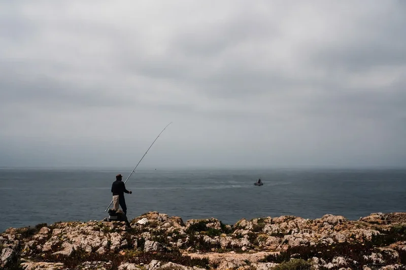
The Fishermen's Trail, or Trilho dos Pescadores, is a world-class coastal hiking route that traces the rugged Atlantic shoreline of southwest Portugal. Spanning 226.5 kilometres from the industrial port of Sines in the Alentejo region to the sun-drenched city of Lagos in the Algarve, this trail is part of the larger Rota Vicentina network. It is widely considered one of the most beautiful coastal walks in the world, offering hikers an intimate encounter with the raw power of the Atlantic Ocean, towering sandstone cliffs, and pristine beaches that remain largely untouched by mass tourism. Unlike the more inland Historical Way, the Fishermen's Trail stays strictly to the coast, following the actual paths used by local fishermen to reach the best spots for rod-and-line fishing from the cliff edges.
- Distance: 226.5 km total (can be walked in sections)
- Duration: 10–14 days
- Season: September to June (avoiding the peak heat of July and August)
- Accommodation: Guesthouses, hostels, and campsites in coastal villages
- Highest point: Approximately 150 m (near Cabo de São Vicente)
- Total Elevation Gain: 5,700 m (cumulative over the entire route)
- Direction: Generally walked North to South (São Torpes to Lagos)
Overview
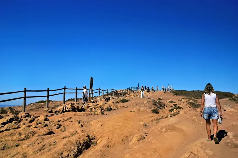
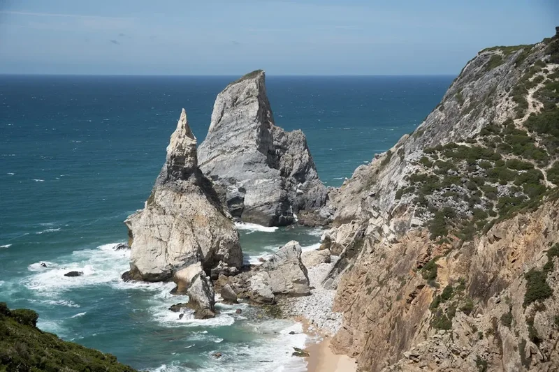
The Fishermen's Trail is a sensory odyssey through the Southwest Alentejo and Vicentine Coast Natural Park. The landscape is defined by its dramatic verticality; hikers spend much of their time traversing the tops of cliffs that plunge 100 metres or more into the churning turquoise waters of the Atlantic. The geology is a fascinating tapestry of dark schist and bright orange sandstone, sculpted over millennia by the relentless wind and salt spray. This is not a flat coastal stroll; the trail is famous—and sometimes infamous—for its deep, soft sand. Walking through these dunes requires significant physical effort, but the reward is access to a landscape that feels prehistoric and profoundly isolated.
One of the most unique features of this trail is the presence of white storks. The Vicentine Coast is the only place in the world where white storks are known to nest on sea stacks—jagged rock pillars rising from the ocean. Watching these majestic birds navigate the gale-force winds to reach their precarious nests is a highlight for any nature enthusiast. The flora is equally captivating, with endemic species like the Vicentine sea lavender and various aromatic shrubs that release a heady scent of honey and salt as you brush past them. The trail transitions from the vast, sweeping beaches of the northern Alentejo to the more intimate, hidden coves of the southern Algarve, culminating in the iconic cliffs of Ponta da Piedade in Lagos.
Culturally, the trail provides a window into a traditional way of life. You will pass through small white-washed villages where the pace of life is dictated by the tides and the seasons. The hospitality of the Alentejo and Algarve people is legendary, and the culinary rewards—fresh grilled sardines, octopus salad, and the famous "percebes" (goose barnacles)—are as much a part of the experience as the hiking itself. While the trail is physically demanding due to the sandy terrain and exposure to the elements, the lack of extreme elevation changes makes it accessible to any hiker with a good level of fitness and a sense of adventure.
History and Cultural Context
The Fishermen's Trail is not a modern invention but a formalisation of ancient footpaths. For centuries, local residents of the Alentejo and Algarve coasts have used these narrow tracks to access the sea. Fishermen would descend precarious cliff faces to reach secret fishing spots, while gatherers would scour the rocks for shellfish. These paths were the lifelines of coastal communities, connecting isolated homesteads to the small ports where their catch could be sold. The trail was officially "born" in 2012 as part of the Rota Vicentina project, a non-profit initiative aimed at promoting sustainable nature tourism in a region that was struggling with depopulation and economic stagnation.
The region itself has a rich and complex history. The Alentejo and Algarve were under Moorish rule for centuries, and this influence is still visible in the architecture of the white-washed houses, the intricate chimney designs, and the agricultural techniques used in the hinterland. The coast was also a strategic frontier during the Age of Discovery; Prince Henry the Navigator is said to have established his school of navigation at Sagres, the "end of the world," where the Fishermen's Trail passes today. The lighthouses that dot the coast, such as the one at Cabo de São Vicente, stand as sentinels of this maritime heritage, guiding ships around one of the busiest shipping lanes in the world.
Today, the trail is managed by the Rota Vicentina Association, which works closely with local landowners and authorities to ensure the paths are maintained and the environment is protected. By walking the Fishermen's Trail, hikers are contributing directly to the local economy, supporting small businesses that might otherwise disappear. The trail represents a successful model of how tourism can be used to preserve both natural beauty and cultural identity, ensuring that the "wild coast" remains wild for generations to come.
Want more background? Read extended notes on history and cultural context → Learn more
Seasonal Highlights and Weather Reality
The Fishermen's Trail is a three-season destination, with each period offering a distinct character. Unlike many European treks, summer is actually the least recommended time to visit. In July and August, temperatures can soar above 35°C, and the lack of shade on the cliff tops makes hiking dangerous. Furthermore, the coastal villages become crowded with domestic tourists, making accommodation difficult to find.
Autumn (September to November): This is arguably the best time to hike. The Atlantic remains warm enough for swimming, the summer crowds have dispersed, and the temperatures drop to a comfortable 20–25°C. The light in autumn is particularly beautiful for photography, with golden sunsets that seem to last for hours. However, this is also the start of the rainy season, so hikers should be prepared for occasional Atlantic storms.
Winter (December to February): Winter on the Vicentine Coast is mild but wild. Daytime temperatures usually hover around 15°C, which is perfect for hiking. The main challenge is the wind; powerful Atlantic gales can make walking on the cliff edges difficult. Many guesthouses and restaurants in the smaller villages close during this period, so careful planning is required. The landscape is incredibly lush and green during winter, and you will likely have the trail entirely to yourself.
Spring (March to June): Spring is a riot of colour. The coastal scrubland erupts in wildflowers, including rare orchids and endemic rockroses. The storks are at their most active, tending to their nests on the sea stacks. Temperatures are ideal, though the sea remains quite cold for swimming until late May. This is the most popular time for the trail, so booking accommodation in advance is essential, especially around Easter.
Recommended Itinerary
13-Stage Fishermen's Trail Itinerary
Stage 1: São Torpes to Porto Covo
- Distance: 10 km
- Elevation gain: 50 m
- Time: 3 hours
- Start at the beach of São Torpes, known for its warm waters
- Easy walking along the coastline with the first taste of sandy paths
- Pass through the small dunes of the Alentejo
- Arrive in the picturesque blue-and-white village of Porto Covo
- A perfect "warm-up" day to test your gear and get used to the sand
Stage 2: Porto Covo to Vila Nova de Milfontes
- Distance: 20 km
- Elevation gain: 160 m
- Time: 6–7 hours
- One of the most challenging stages due to extensive deep sand
- Pass the Ilha do Pessegueiro (Peach Tree Island) and its historic fort
- Spectacular cliff-top views and hidden beaches like Praia do Malhão
- Arrive in Vila Nova de Milfontes, situated on the estuary of the Mira River
- Requires high physical endurance; ensure you have plenty of water
Stage 3: Vila Nova de Milfontes to Almograve
- Distance: 15 km
- Elevation gain: 90 m
- Time: 4–5 hours
- Cross the Mira River via the bridge (or take a small ferry in season)
- Walk through diverse landscapes, including pine forests and acacia groves
- Dramatic red sandstone cliffs appear as you approach Almograve
- Almograve is a tiny, quiet village perfect for a peaceful evening
- A shorter day that allows for a relaxed afternoon on the beach
Stage 4: Almograve to Zambujeira do Mar
- Distance: 22 km
- Elevation gain: 200 m
- Time: 6–7 hours
- Pass the fishing harbour of Entrada da Barca
- Look for the famous stork nests on the sea stacks near Cabo Sardão
- Visit the Cabo Sardão lighthouse, the only one in Portugal facing landward
- Arrive in Zambujeira do Mar, a village perched dramatically on the cliffs
- One of the most scenic days of the entire trek
Stage 5: Zambujeira do Mar to Odeceixe
- Distance: 18 km
- Elevation gain: 260 m
- Time: 5–6 hours
- Pass through the Azenha do Mar fishing village (great for lunch)
- The trail crosses from the Alentejo region into the Algarve
- Stunning descent into the Seixe River valley
- Arrive in Odeceixe, famous for its horseshoe-shaped beach
- The village is located 3 km inland from the beach; many hikers stay in the village centre
Stage 6: Odeceixe to Aljezur
- Distance: 18 km
- Elevation gain: 200 m
- Time: 5–6 hours
- Follows the "Reguengo" irrigation canal for a significant portion
- Transition from coastal cliffs to more inland, agricultural landscapes
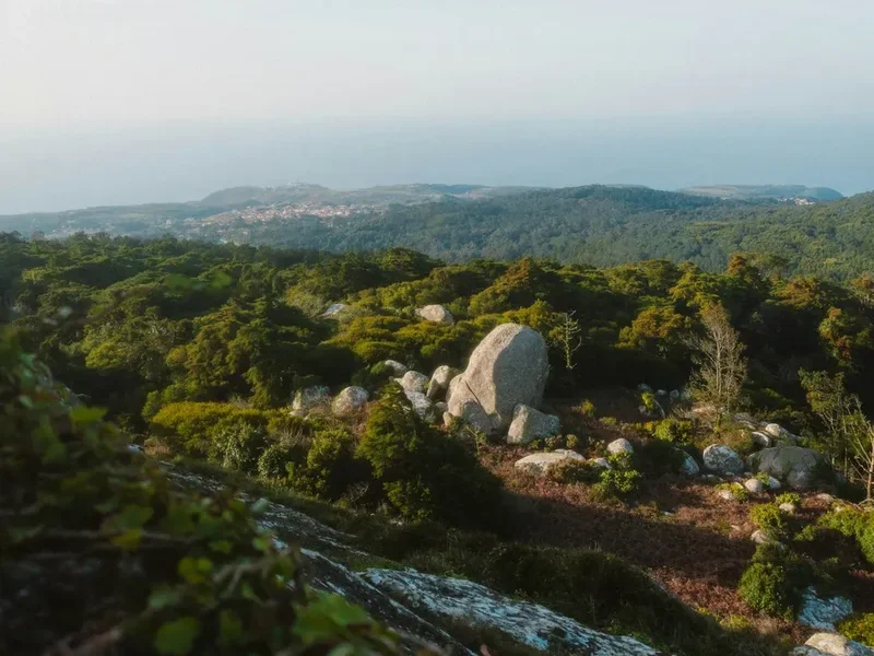
- Views of the Monchique mountains in the distance
- Arrive in Aljezur, dominated by its Moorish castle ruins
- Explore the old town's narrow streets and steep hills
Stage 7: Aljezur to Arrifana
- Distance: 12 km
- Elevation gain: 300 m
- Time: 4 hours
- A shorter but hilly stage with significant elevation changes
- Pass through the Ribat of Arrifana, an ancient Moorish fortress site
- Spectacular views of the Arrifana bay, a mecca for surfers
- Arrive in Arrifana, a small settlement focused on the beach
- Great spot to watch the sunset from the cliff-top ruins
Stage 8: Arrifana to Carrapateira
- Distance: 24 km
- Elevation gain: 400 m
- Time: 7–8 hours
- A long and demanding day through wild, uninhabited territory
- Pass the Bordeira beach, one of the largest and most beautiful in Portugal
- The trail loops around the Pontal da Carrapateira headland
- Arrive in the surf-centric village of Carrapateira
- Requires careful pacing and early start
Stage 9: Carrapateira to Vila do Bispo
- Distance: 16 km
- Elevation gain: 300 m
- Time: 5 hours
- Walk through the "Amado" beach area, famous for international surf competitions
- The landscape becomes more arid and windswept as you head south
- Arrive in Vila do Bispo, a traditional inland town
- Known for its excellent seafood restaurants serving local barnacles
Stage 10: Vila do Bispo to Sagres
- Distance: 20.5 km
- Elevation gain: 200 m
- Time: 6 hours
- The "End of the World" stage leading to Cabo de São Vicente
- Walk along the highest cliffs of the Algarve
- Visit the lighthouse at the southwesternmost point of Europe
- Final stretch into the town of Sagres
- A deeply symbolic day for many hikers
Stage 11: Sagres to Salema
- Distance: 19.5 km
- Elevation gain: 450 m
- Time: 6 hours
- The trail turns east, following the south coast of the Algarve
- Pass through several hidden, pristine beaches like Praia do Barranco
- More frequent ups and downs as you cross small ravines
- Arrive in the former fishing village of Salema
- Look for dinosaur footprints on the rocks at Salema beach
Stage 12: Salema to Luz
- Distance: 12 km
- Elevation gain: 350 m
- Time: 4 hours
- Pass through the village of Burgau, often called the "Santorini of Portugal"
- Coastal paths with views of the limestone cliffs characteristic of the central Algarve
- Arrive in the resort town of Praia da Luz
- A shorter day allowing for recovery before the final push
Stage 13: Luz to Lagos
- Distance: 11 km
- Elevation gain: 200 m
- Time: 3–4 hours
- The grand finale along the cliffs of Ponta da Piedade
- Pass the iconic lighthouse and the sea caves of Lagos
- Walk down into the historic centre of Lagos
- Finish at the Lagos railway station or the marina
- Celebrate the completion of over 220 km of coastal trekking
Planning and Bookings
Book Your Trip
Everything you need to plan your journey
Accommodation
Find places to stay near Lagos
Flights
Search flights to Lagos
Essential Preparation
The Fishermen's Trail is a moderate trek, but it should not be underestimated. The primary challenge is the terrain; walking in soft sand for several hours a day is taxing on the calves and Achilles tendons. It is highly recommended to train on sandy beaches or soft trails before arriving. Logistics are relatively straightforward, as the trail passes through a village every 15–25 kilometres, meaning you don't need to carry more than a day's worth of food and water.
Lagos and Sines are the main transport hubs. Most hikers fly into Lisbon (LIS) or Faro (FAO). From Lisbon, Rede Expressos buses run frequently to Sines and Porto Covo. From Faro, trains and buses connect to Lagos. If you are walking the full trail, it is common to leave a bag in Lagos and take the bus north to start in São Torpes. Booking accommodation in advance is critical during the peak months of April, May, and September. Many villages are small, and the limited beds fill up quickly with hikers and surfers.
Trail Accommodation
There is no wild camping allowed on the Fishermen's Trail, as it passes through a protected Natural Park. Hikers must stay in official accommodation, which ranges from budget-friendly hostels to high-end boutique guesthouses.
Types of Accommodation:
- Hostels: Available in larger towns like Vila Nova de Milfontes, Aljezur, and Sagres. Expect to pay €25–€35 for a dorm bed.
- Guesthouses (Pensões): The most common option. These are often family-run and provide a more authentic experience. Costs range from €50–€90 for a double room.
- Campsites: There are several excellent campsites along the route (e.g., in Porto Covo, Zambujeira, and Sagres). These are well-equipped with showers, shops, and sometimes pools.
- Rural Tourism (Turismo Rural): Located slightly inland, these offer high comfort and often include breakfast with local produce.
Facilities Provided: Most guesthouses provide linens, towels, and WiFi. Breakfast is usually included or available for a small fee. Many establishments are "Rota Vicentina Partners" and are specifically geared toward hikers, offering laundry services and luggage transfer coordination.
What's NOT Provided: Do not expect air conditioning in older guesthouses (though it is rarely needed with the sea breeze). Most places do not have communal kitchens, so you will be eating out or buying picnic supplies at local "minimercados."
Required Gear
- Footwear: Trail running shoes or lightweight hiking boots. Heavy, stiff leather boots are generally not recommended as they are cumbersome in the sand and can lead to overheating. Ensure your footwear has a good "gusseted" tongue to keep sand out.
- Gaiters: Short "sand gaiters" are a game-changer on this trail. They prevent sand from entering your shoes, which is the primary cause of blisters on the Fishermen's Trail.
- Backpack: A 30–40L pack is sufficient if you are staying in guesthouses. If you are camping, you will need 50–60L.
- Sun Protection: A wide-brimmed hat with a chin strap (it gets very windy), high-SPF sunscreen, and quality sunglasses. The reflection of the sun off the sand and sea is intense.
- Clothing: Lightweight, moisture-wicking fabrics. Long sleeves and trousers can help protect against both the sun and the scratchy coastal scrub. A windproof shell is essential for the cliff-top sections.
- Navigation: The trail is exceptionally well-marked with blue and green stripes. However, having the Rota Vicentina app or a GPX track on your phone is recommended for peace of mind.
What to Bring
- Water: At least 2–3 litres per day. There are no water sources between villages, and the sun can be dehydrating. A hydration bladder is more convenient than bottles.
- Snacks: High-energy snacks like nuts, dried fruit, and Portuguese "broas" (honey cakes). You can buy fresh fruit and bread in the villages each morning.
- First Aid: Blister plasters (Compeed), antiseptic cream, and basic painkillers. Sand-induced friction is the most common medical issue.
- Power Bank: To keep your phone charged for navigation and photos, as some older guesthouses have limited outlets.
- Cash: While cards are widely accepted in larger towns, many small cafés and guesthouses in the Alentejo still only accept cash (Euros).
- Swimwear: You will pass some of the world's best beaches every day—don't miss the chance for a refreshing Atlantic dip.
Permits
One of the great appeals of the Fishermen's Trail is its accessibility: no permits are required to walk the trail. There are no entry fees for the Southwest Alentejo and Vicentine Coast Natural Park, and you do not need to register with any authority before starting your journey. The trail is open to everyone, year-round.
Booking Strategy:
- While the trail itself is free, your "permit" to a good night's sleep is your accommodation booking. During the peak spring and autumn seasons, you should book at least 2–3 months in advance.
- If you are travelling solo, be aware that single rooms are limited and often cost nearly as much as doubles.
- Consider using a luggage transfer service (like Vicentina Transfers). This allows you to walk with just a daypack, which makes the sandy sections much more manageable. These services must be booked at least 48 hours in advance.
Regulations:
- Wild camping is strictly prohibited and can result in heavy fines. The local GNR (police) do patrol the coastal areas, especially in summer.
- Cycling is not allowed on the Fishermen's Trail sections. The fragile cliff-top ecosystems and narrow paths are for hikers only. Cyclists should use the Historical Way or the dedicated Rota Vicentina cycling routes.
- Dogs are allowed but must be kept on a lead to protect nesting birds and local livestock.
Other Activities in the Area
The southwest coast of Portugal is a playground for outdoor enthusiasts and culture seekers. Consider adding a few "rest days" to your itinerary to experience the following:
- Surfing: The Alentejo and Algarve coasts offer some of the most consistent swells in Europe. Arrifana, Sagres, and Carrapateira are world-renowned surf spots with schools catering to all levels.
- Bird Watching: Beyond the storks, the region is a major migratory flyway. In autumn, the Sagres peninsula becomes a hotspot for observing raptors, including eagles and vultures, as they prepare to cross to Africa.
- Wine Tasting: The Alentejo is one of Portugal's premier wine regions. While the coast is too salty for vineyards, a short drive inland will take you to world-class wineries producing bold reds and crisp whites.
- Boat Tours: In Lagos, take a boat or kayak tour of the Ponta da Piedade sea caves. Seeing the cliffs you just walked from the perspective of the water is a fitting conclusion to the trip.
- Gastronomy Workshops: Some local guesthouses offer cooking classes where you can learn to make traditional dishes like Cataplana (a seafood stew) or the famous Pastel de Nata.
Safety and Conditions
Cliff Erosion: This is the most significant hazard on the Fishermen's Trail. The cliffs are composed of sandstone and schist, which are highly susceptible to erosion and landslides. Never bypass trail markers to get a "better photo" near the edge. Large sections of the cliff can collapse without warning, especially after heavy rain. Always stay on the marked path.
Heat and Exposure: There is virtually no shade on the Fishermen's Trail. Heatstroke and severe sunburn are real risks. Start your walk as early as possible (7:00 AM) to finish before the hottest part of the day. Wear a hat and use high-factor sunscreen, reapplying frequently.
Tides: While most of the trail stays high on the cliffs, some sections (like the crossing of the Mira River or certain beach detours) are tide-dependent. Always check the local tide tables if you plan to walk along the sand rather than the cliff-top path. The Atlantic tide can come in surprisingly fast.
Wildlife: There are no dangerous large animals in the region. However, be mindful of processionary caterpillars in pine forests during late winter and spring; their hairs are highly irritating to skin and dangerous to dogs. Ticks can also be present in the tall grass, so perform a check at the end of each day.
Emergency Services: The national emergency number in Portugal is 112. Mobile signal is generally good along the coast, but there are "dead zones" in the deeper ravines and isolated valleys. Always let your accommodation provider know your expected arrival time.
Side Trips and Points of Interest
Cabo de São Vicente: The southwesternmost point of Europe. The lighthouse here is one of the most powerful in the world, with a beam that can be seen for 60 kilometres. The site has been considered sacred since the Neolithic period and was known to the Romans as Promontorium Sacrum. Standing here, with nothing but 5,000 kilometres of ocean between you and America, is a profound experience.
The Ribat of Arrifana: Located on a narrow headland near Aljezur, this is the site of a 12th-century Sufi fortress-monastery. It is one of the most important archaeological sites on the Iberian Peninsula, representing a unique blend of military and religious architecture from the Almohad period.
Dinosaur Footprints: On the rocks at the western end of Salema beach, you can find clearly preserved footprints of an Ornithopod dinosaur from the Lower Cretaceous period. They are best viewed at low tide and are a startling reminder of the deep time embedded in this landscape.
The Sagres Fortress: A massive 15th-century fortification that occupies the entire Ponta de Sagres headland. Inside, you can see a giant wind compass (Rosa dos Ventos) laid out in stone on the ground, measuring 43 metres in diameter. It is a testament to the region's role in the history of global exploration.
Leave No Trace
The Fishermen's Trail passes through a fragile ecosystem that is under increasing pressure from tourism. The dunes are particularly sensitive; the plants that grow there, such as European beachgrass, are essential for anchoring the sand and preventing erosion. Stepping off the path can destroy these plants and lead to the destabilisation of the entire dune system.
Your responsibility as a hiker:
- Stay on the marked trail: This is the single most important thing you can do to protect the Vicentine Coast.
- Pack out all trash: This includes organic waste like orange peels and banana skins, which decompose very slowly in the salty, arid coastal environment.
- Respect the storks: Do not use drones near the sea stacks, as this can cause the birds to abandon their nests. Keep noise to a minimum when passing nesting sites.
- Use official toilets: Use the facilities in the villages before you start your day. If you must go on the trail, ensure you are at least 50 metres from the path and any water source, and bury all waste deeply. Carry out your toilet paper in a sealed bag.
- Do not pick wildflowers: Many of the species here are endemic and protected by law. Take photos, not souvenirs.
- Conserve water: The Alentejo and Algarve are water-scarce regions. Keep your showers short and be mindful of your water usage in guesthouses.