Fish River Canyon Hike - Africa’s Greatest Chasm
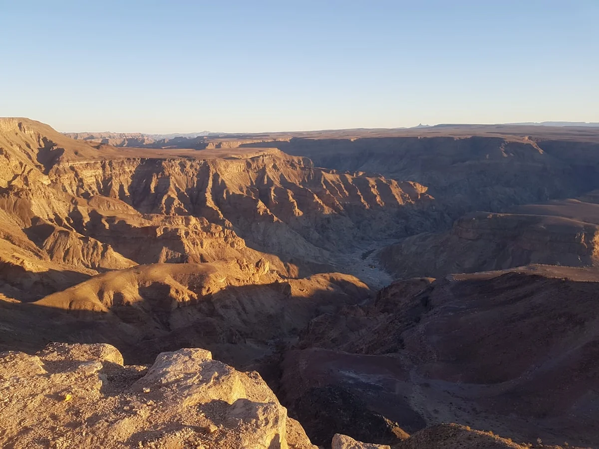
The Fish River Canyon Hike is widely regarded as one of the most challenging and rewarding multi-day treks in Africa. Located in the far south of Namibia, within the /Ai-/Ais Richtersveld Transfrontier Park, this 85-kilometre expedition traverses the floor of the second-largest canyon in the world. Unlike many world-class trails that offer manicured paths and comfortable huts, the Fish River Canyon is a raw, self-sufficient wilderness experience. There are no facilities, no fixed campsites, and no escape routes once the descent into the canyon is completed. Hikers must carry everything they need to survive for five days in a landscape defined by towering rock faces, vast sandy riverbeds, and ancient geological formations that date back over 500 million years.
The journey begins at the Hobas viewpoint, where the sheer scale of the canyon first reveals itself, and concludes at the thermal springs of Ai-Ais. Between these two points lies a world of profound isolation. The trail follows the meandering course of the Fish River, which, during the hiking season, is often reduced to a series of turquoise pools connected by thin ribbons of water or dry stretches of sand and boulders. This is a trek that tests physical endurance, mental fortitude, and navigational skills, offering in return a connection to the earth’s deep history that few other places on the planet can provide.
- Distance: 85.0 km (approximate, depending on shortcuts taken)
- Duration: 4–5 days
- Season: 1 May to 15 September (strictly enforced for safety)
- Accommodation: Wild camping (no huts or facilities inside the canyon)
- Highest point: Canyon Rim at Hobas (approx. 1,150 m)
- Lowest point: Ai-Ais (approx. 230 m)
- Difficulty: Challenging (requires high fitness and self-sufficiency)
- Direction: North to South (Hobas to Ai-Ais only)
Overview
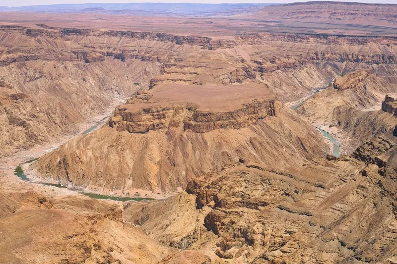
The Fish River Canyon is a geological titan. Stretching 160 kilometres in length and reaching widths of up to 27 kilometres, the canyon plunges to depths of 550 metres. The hike itself covers the most dramatic southern section of this chasm. It is not a "trail" in the traditional sense; there is no marked path to follow. Instead, hikers navigate by the river’s course, choosing their own lines through boulder fields, over soft river sand, and across rocky plateaus. The environment is unforgiving, with daytime temperatures often reaching 30°C even in winter, while night-time temperatures in the desert can drop toward freezing.
The experience is defined by the "no-exit" policy. Once you descend the steep, technical path from the rim to the canyon floor, you are committed to the full 85-kilometre journey. The only way out is forward to Ai-Ais or backward up the near-vertical descent at the start. This creates a psychological weight to the hike that heightens the sense of adventure. You are truly "in it," separated from the modern world by hundreds of metres of vertical rock. The silence of the canyon is absolute, broken only by the occasional call of a fish eagle or the crunch of boots on gravel.
The landscape changes subtly but significantly as you progress. The upper canyon is narrow and vertical, with dramatic "incised meanders" where the river has carved deep into the gneiss and schist. As you move south, the canyon widens, revealing the "Four Finger Rock" and the "Three Sisters" formations. The flora is equally specialised, featuring the iconic Quiver Tree (Aloidendron dichotomum) and the bizarre "Halfmens" succulent, both of which have evolved to survive in one of the most arid regions on the continent. For those seeking a true wilderness expedition that strips away the comforts of modern life, the Fish River Canyon is an unparalleled destination.
History and Cultural Context
The geological history of the Fish River Canyon is a saga of tectonic shifts and erosion spanning half a billion years. The canyon began to form approximately 500 million years ago during a period of tectonic uplift. As the African continent underwent massive stress, a "graben" (a depressed block of the earth's crust) formed, creating a wide, shallow valley. It wasn't until the breakup of the supercontinent Gondwana about 120 million years ago that the Fish River began to erode the deeper, narrower inner canyon we see today. The river followed the faults and fractures in the ancient basement rock, creating the spectacular meanders that are a hallmark of the trail.
To the local Nama people, the canyon’s origin has a more legendary explanation. Folklore tells of a giant serpent named Koutein Kooru who was pursued by hunters. As the serpent fled across the desert, its massive, writhing body gouged deep furrows into the earth, creating the twists and turns of the Fish River Canyon. This cultural connection to the land remains strong, and the canyon is part of the /Ai-/Ais Richtersveld Transfrontier Park, a peace park that straddles the border between Namibia and South Africa, managed in part by the local communities.
In more recent history, the canyon served as a site of conflict and refuge. During the German colonial era in the early 20th century, the rugged terrain provided a hiding place for Nama forces resisting German rule. A poignant reminder of this era is the grave of Lieutenant Thilo von Trotha, a German officer who was killed in 1905 during a parley with the Nama. His grave remains a lonely landmark on the canyon floor, a testament to the harsh and storied past of this remote wilderness. Today, the canyon is a protected national monument, recognised globally for its geological significance and its status as a premier trekking destination.
Want more background? Read extended notes on history and cultural context → Learn more
Seasonal Highlights and Weather Reality
The Fish River Canyon Hike is only open from 1 May to 15 September each year. Outside of these months, the hike is strictly prohibited due to extreme heat. During the Namibian summer (October to April), temperatures on the canyon floor can easily exceed 50°C. Because the canyon walls trap heat and there is very little air movement, the environment becomes a literal oven, making physical exertion life-threatening. Additionally, summer is the rainy season in the interior of Namibia; while it may not rain in the canyon itself, flash floods can roar down the Fish River with very little warning, posing a catastrophic risk to anyone on the canyon floor.
Winter (May to August): This is the prime hiking window. Daytime temperatures typically range between 20°C and 30°C, providing comfortable conditions for heavy trekking. However, the desert climate means that as soon as the sun sets, temperatures plummet. Night-time lows can reach 5°C or even 0°C in the deeper sections of the canyon. Hikers must be prepared for this massive diurnal temperature swing with both sun protection and warm evening layers.
Shoulder Season (September): By early September, the heat begins to return. While the trail remains open, hikers should expect hotter days (35°C+) and should plan to do the bulk of their walking in the early morning hours. Water levels in the river also tend to be at their lowest in September, meaning pools may be more stagnant and require careful filtration.
Weather in the canyon is generally stable and dry during the winter, but wind can be a factor. Strong gusts can funnel through the canyon, making it difficult to pitch tents or cook. Sandstorms are rare but possible. Always check the long-range forecast at Hobas before descending, as unseasonal cold fronts can occasionally bring rain or extreme wind to the south of Namibia.
Recommended Itinerary
5-Day Fish River Canyon Itinerary
Day 1: Hobas Rim to the Canyon Floor
- Distance: 10 km (including the descent)
- Elevation loss: 550 m
- Time: 4–5 hours
- Start at the Hobas Viewpoint for a final look at the route from above.
- The descent is the most technical part of the hike; it is steep, rocky, and requires careful footwork. Chains are provided in the steepest sections.
- Once at the bottom, the trail follows the river south.
- Camp near the first large pools of water. The sand is soft, so choose a spot sheltered from potential wind.
- The first night in the canyon is often the most atmospheric, as the scale of the walls above becomes apparent in the moonlight.
Day 2: The Upper Canyon and Palm Springs
- Distance: 18 km
- Elevation: Minimal gain/loss, mostly flat riverbed
- Time: 7–8 hours
- The canyon is narrow here, with dramatic vertical cliffs.
- Walking is a mix of heavy sand and large boulder fields, which can be slow going.
- Pass the "Grave of Lieutenant von Trotha" on the eastern bank.
- Reach Palm Springs, where natural hot sulphur water bubbles up from the earth. The water is around 57°C at the source but cools in the pools.
- Note: The sulphur water is drinkable but has a strong taste and can have a laxative effect; most hikers prefer to collect water further downstream.
- Camp a few kilometres past Palm Springs to avoid the smell of sulphur and the evening insects.
Day 3: The Middle Canyon and Three Sisters
- Distance: 20 km
- Elevation: Minimal
- Time: 8–9 hours
- The canyon begins to widen, and the river meanders significantly.
- This is the day of "The Big Bend." Many hikers choose to take the first major shortcut across the neck of a meander to save several kilometres.
- Pass the "Three Sisters" rock formation, a series of three prominent towers on the canyon wall.
- The terrain remains a challenge, with thick sand and river stones testing the ankles.
- Camp near a large, clear pool. This is often the halfway point of the trek.
Day 4: The Lower Canyon and the Shortcuts
- Distance: 22 km (using shortcuts)
- Elevation: Minimal
- Time: 8–9 hours
- The landscape opens up into a vast, desert-like environment.
- Several significant shortcuts are available today. These involve climbing over low ridges rather than following the river's long loops.
- Pass "Four Finger Rock," a distinctive pinnacle that looks like a hand reaching out of the canyon floor.
- The heat can be more intense here as the canyon walls are further apart and provide less shade.
- Camp at "Vasbyt Bend" or "Pink Palace" (a colourful rock formation). This is the final night under the stars.
Day 5: The Final Stretch to Ai-Ais
- Distance: 15 km
- Elevation: Minimal
- Time: 4–5 hours
- The final day is mostly flat and follows a wider riverbed.
- The goal is the Ai-Ais Hot Springs Resort. The sight of the resort’s palm trees and buildings is a welcome relief.
- The trail ends at the resort gates.
- Celebrate with a soak in the thermal pools and a cold drink at the bar.
- Most hikers arrange a shuttle back to Hobas or their vehicles from here.
Important Notes:
- Distances are estimates; your actual GPS track will vary based on which side of the river you walk on and which shortcuts you take.
- There are no trail markers. Navigation is by sight and map.
- Group size must be between 3 and 30 people for safety reasons. Solo hiking is strictly forbidden.
- A medical certificate of fitness is mandatory and must be presented at Hobas.
Planning and Bookings
Book Your Trip
Everything you need to plan your journey
Accommodation
Find places to stay near Windhoek
Flights
Search flights to Windhoek
Essential Preparation
The Fish River Canyon Hike requires meticulous planning. Because it is a self-sufficient trek, your pack weight will be significant (often 15–22 kg at the start). Fitness is paramount; you should be comfortable walking 20 kilometres a day on uneven, sandy terrain with a heavy load. Training should include multi-day hikes and strength training for your legs and core.
Logistically, the hike starts at Hobas and ends at Ai-Ais. These two points are roughly 70 kilometres apart by road. Most hikers leave their vehicles at Ai-Ais and take a pre-booked shuttle to the start at Hobas. This ensures your car is waiting for you at the finish. Windhoek is the nearest major city, approximately 800 kilometres (8–10 hours drive) to the north. Ensure your vehicle is suitable for gravel roads, as the final stretches to the park are not paved.
Trail Accommodation
There is no formal accommodation inside the Fish River Canyon. This is a wild camping experience in its purest form.
Inside the Canyon:
- You may camp anywhere you choose on the canyon floor.
- Most hikers choose sandy patches near water pools.
- There are no toilets, no showers, and no shelters.
- Fires are strictly prohibited; all cooking must be done on portable gas stoves.
- You must carry out all your rubbish (Leave No Trace).
At the Trailheads:
- Hobas (Start): Offers a campsite with basic facilities (toilets, showers, braai areas). It is recommended to stay here the night before you start.
- Ai-Ais (Finish): A full resort managed by Namibia Wildlife Resorts (NWR). It features campsites, rooms, a restaurant, a bar, and thermal indoor/outdoor pools. Booking a room or a campsite here for the night you finish is highly recommended.
Required Gear
- Backpack: 60–75L capacity with a high-quality harness system.
- Footwear: Sturdy, well-broken-in hiking boots with excellent ankle support. The terrain is brutal on shoes.
- Sand Gaiters: Essential to keep sand and small stones out of your boots.
- Sleeping Bag: A 3-season bag rated to 0°C. Desert nights are cold.
- Sleeping Mat: Lightweight inflatable or closed-cell foam mat for insulation from the cold ground.
- Tent or Bivvy: A lightweight, wind-resistant tent. Many hikers sleep under the stars, but a tent provides protection from wind and insects.
- Stove and Fuel: Lightweight gas stove (e.g., Jetboil or MSR). Ensure you have enough gas for 5 days.
- Water Purification: High-quality filter (e.g., Sawyer Squeeze or Katadyn) or purification tablets. The river water can be stagnant and full of algae.
- Navigation: A detailed topographic map and a compass or GPS.
- First Aid Kit: Must include blister care (moleskin, Leukotape), rehydration salts, anti-inflammatories, and a space blanket.
What to Bring
- Food: High-calorie, lightweight dehydrated meals. Avoid heavy tins. Bring plenty of snacks (nuts, dried fruit, energy bars).
- Electrolytes: Essential for preventing cramps and heat exhaustion in the dry desert air.
- Water Containers: Capacity to carry at least 3–4 litres of water at any time.
- Clothing: Moisture-wicking base layers, a wide-brimmed hat, high-quality wool socks (plus spares), a warm fleece or down jacket for evenings, and lightweight long-sleeved shirts for sun protection.
- Sun Protection: SPF 50+ sunscreen, lip balm with SPF, and high-quality sunglasses.
- Toiletries: Biodegradable soap, trowel for waste, toilet paper, and wet wipes.
- Headlamp: With spare batteries.
- Power Bank: To keep your phone/GPS charged (there is no electricity in the canyon).
Permits
Permits for the Fish River Canyon Hike are mandatory and are issued by Namibia Wildlife Resorts (NWR). Due to the trail's popularity and the strict limit on the number of hikers allowed per day, it is essential to book months in advance. Bookings usually open a year ahead, and peak dates in June and July sell out almost instantly.
Permit Requirements:
- Medical Certificate: Every hiker must present a medical certificate of fitness, signed by a doctor within 40 days of the hike start date. You will not be allowed to descend without this.
- Group Size: A minimum of 3 people is required to start the hike. This is a safety regulation; if one person is injured, one can stay with them while the third seeks help.
- Age Limit: Hikers must be at least 12 years old.
Costs (Approximate):
- Hiking Permit: Approx. N$500 per person.
- Park Entrance Fee: Approx. N$150 per person per day (payable at Hobas).
- Shuttle Service: Approx. N$300–N$400 per person for the Ai-Ais to Hobas transfer.
Permits can be booked through the NWR central reservations office in Windhoek or via their official website. Ensure you receive a written confirmation and keep a printed copy with your medical certificate to present at the Hobas park office.
Other Activities in the Area
The south of Namibia is a land of vast horizons and unique attractions. Consider these additions to your itinerary:
- Ai-Ais Hot Springs: Even if you aren't hiking, the thermal waters are a major draw. The name "Ai-Ais" means "burning water" in the local Nama language.
- Canyon Rim Viewpoints: For those not doing the full hike, several viewpoints near Hobas offer spectacular vistas of the Fish River Canyon's main meanders.
- Lüderitz and Kolmanskop: A 4-hour drive west takes you to the coast. Kolmanskop is a famous ghost town slowly being swallowed by the dunes of the Namib Desert—a photographer's paradise.
- Quiver Tree Forest: Located near Keetmanshoop, this is a dense stand of the iconic Aloidendron dichotomum, particularly beautiful at sunset.
- Giant's Playground: Situated near the Quiver Tree Forest, this is a bizarre landscape of stacked dolerite boulders that look like a giant's building blocks.
- Orange River Canoeing: Further south on the border with South Africa, multi-day paddling trips on the Orange River offer a different perspective on the desert landscape.
Safety and Conditions
The Fish River Canyon is a high-risk environment. There is no cell phone reception inside the canyon, and the rugged terrain makes rescue operations extremely difficult and time-consuming. Safety is the responsibility of the hiking group.
Heat and Hydration: Heat exhaustion and heatstroke are the primary dangers. Drink water constantly, even if you don't feel thirsty. Use electrolyte replacements to maintain salt balance. If a group member shows signs of confusion, extreme fatigue, or stops sweating, stop immediately in the shade, cool them with water, and rest.
Water Safety: The Fish River is not a flowing river in winter; it is a series of pools. Some pools are fresh, while others are stagnant and salty. Always filter or treat your water. Avoid pools with dead animals or excessive green slime. In the lower canyon, water can become more scarce, so fill up whenever you find a good source.
Injuries: Sprained ankles and knee injuries are common due to the boulder hopping and soft sand. Carry a comprehensive first aid kit and know how to use it. If a serious injury occurs, the group must decide whether to send two people ahead to Ai-Ais to raise the alarm. In extreme emergencies, a helicopter evacuation may be possible, but it is weather-dependent and very expensive.
Flash Floods: While rare in winter, they are possible if there is heavy rain in the catchment area hundreds of kilometres to the north. If the river starts to rise or becomes muddy, move to higher ground immediately. Never camp in the direct centre of the riverbed if there is any cloud cover in the distance.
Wildlife: You may encounter baboons, klipspringers, and Hartmann's mountain zebra. Leopards are present but very rarely seen. Scorpions and snakes (such as the Horned Adder) exist; always check your boots in the morning and use a headlamp when walking at night.
Side Trips and Points of Interest
While the main goal is to reach Ai-Ais, there are several notable features to look out for along the way:
The Sulphur Springs (Palm Springs): Located about 25 kilometres from the start, these thermal springs are a geological marvel. The water emerges at a temperature of 57°C. While the smell of sulphur is strong, the pools offer a unique "spa" experience in the middle of the wilderness. It is a popular spot for a midday break on Day 2.
The Grave of Lieutenant von Trotha: A small stone masonry grave located on the eastern side of the river in the upper canyon. It marks the spot where a German officer was killed in 1905. It is a somber reminder of the canyon's history and a common landmark for hikers to verify their position.
The Four Finger Rock: This massive rock formation consists of four distinct stone towers that resemble a hand. It is located in the lower canyon and serves as a major navigational landmark. It is particularly striking in the late afternoon light.
The Shortcuts: While not "points of interest" in the traditional sense, the shortcuts are a fundamental part of the Fish River experience. Learning to read the topography to identify where you can cut across a meander is a rewarding challenge. The "Koelkrans" shortcut is one of the most famous, offering a steep but rewarding bypass of a long river loop.
Leave No Trace
The Fish River Canyon is a fragile desert ecosystem. Because of the high volume of hikers during the short season, the impact on the environment can be significant if rules are not followed. We have a collective responsibility to keep this wilderness pristine.
Core Principles:
- Carry Out All Trash: This includes organic waste like orange peels and tea bags, which do not decompose quickly in the arid environment. If you find trash left by others, please pick it up.
- Human Waste: Use the "cat hole" method. Dig a hole at least 15–20 cm deep, at least 50 metres away from any water source. Pack out your used toilet paper in a sealed plastic bag; do not bury it or burn it, as animals often dig it up.
- No Fires: Wood is extremely scarce in the canyon and provides vital habitat for insects and small reptiles. Use a gas stove for all cooking.
- Washing: Do not use soap or detergent directly in the river pools. Even biodegradable soap can harm the delicate aquatic life in stagnant pools. Collect water in a container and wash at least 30 metres away from the water's edge.
- Respect the Silence: Avoid loud music or shouting. The silence is part of the canyon's heritage.