Fimmvörðuháls Pass - Between Two Glaciers
The Fimmvörðuháls Pass is arguably Iceland’s most spectacular day hike, a 25-kilometre trek that traverses the high mountain ridge between the Eyjafjallajökull and Mýrdalsjökull glaciers. Connecting the coastal village of Skógar to the emerald valley of Þórsmörk (Thor’s Woods), this trail offers a concentrated dose of Iceland’s most dramatic geological features. Walkers begin at the base of the mighty Skógafoss waterfall, ascending alongside the Skógá River—home to no fewer than 26 distinct waterfalls—before entering a stark, lunar landscape of fresh lava fields, steaming craters, and ice-capped peaks. The route gained international fame following the 2010 eruption of Eyjafjallajökull, which created two brand-new volcanic craters, Magni and Móði, directly along the path. This is a journey of extreme contrasts: from the lush, mossy cliffs of the south coast to the desolate, wind-swept volcanic plateau, and finally descending into the jagged, birch-filled ridges of the Icelandic highlands. It is a physically demanding trek that requires respect for the volatile Arctic weather, but for those who undertake it, Fimmvörðuháls provides an unparalleled window into the raw, creative power of the Earth.
- Distance: 25.0 km one-way
- Duration: 1–2 days (typically 8–12 hours as a day hike)
- Season: Mid-June to mid-September (weather dependent)
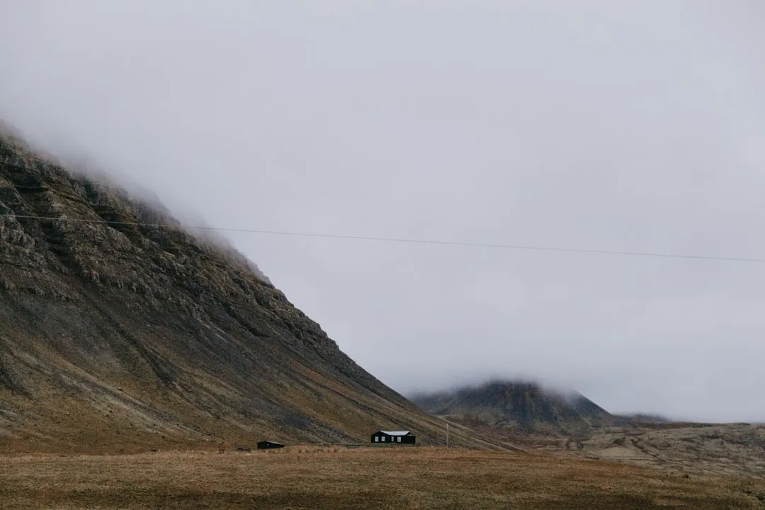
- Huts: Baldvinsskáli and Fimmvörðuskáli (bookings essential for overnight stays)
- Highest point: 1,068 metres (near the Fimmvörðuskáli hut)
- Elevation Gain: Approximately 1,000 metres
- Direction: Most commonly hiked south to north (Skógar to Þórsmörk)
Overview
The Fimmvörðuháls Pass is often described as a "microcosm of Iceland." Within a single day’s walk, hikers experience the full spectrum of the island’s landscapes. The trail is traditionally divided into three distinct geographical stages, each with its own character and challenges. The first stage, known as the "Waterfall Way," follows the Skógá River as it tumbles down from the highlands. This section is a lush, green corridor where the path winds past an incredible succession of cascades, each unique in shape and scale. The roar of the water and the vibrant green of the moss-covered cliffs provide a sensory-rich introduction to the trek.
As the trail leaves the river behind, it enters the second stage: the high mountain pass. Here, the greenery vanishes, replaced by a stark world of black volcanic sand, grey ash, and permanent snowfields. This is the most technically and meteorologically challenging part of the hike. Walkers pass between the two massive ice caps of Eyjafjallajökull and Mýrdalsjökull, crossing the very ground that was molten lava during the 2010 eruption. The presence of the new craters, Magni and Móði, serves as a humbling reminder of the region's active volcanism. The air is often colder here, and the wind can be fierce, but the sense of isolation and the scale of the surrounding glaciers are profound.
The final stage is the descent into Þórsmörk. This section is widely considered one of the most beautiful stretches of trail in the world. As the path drops off the volcanic plateau, hikers are treated to panoramic views of the Goðaland (Land of the Gods) region. The descent involves navigating narrow ridges, such as the famous Kattarhryggur (Cat’s Spine), and traversing steep, scree-covered slopes. The landscape transforms once again as the trail enters the birch forests of Þórsmörk, a rare sight in Iceland. The journey concludes in a valley surrounded by three glaciers, where the braided rivers of the Krossá valley spread out across the plains. Whether completed in a single grueling day or split into two with a night in a mountain hut, the Fimmvörðuháls Pass is a transformative experience that tests the body and inspires the spirit.
History and Cultural Context
The name "Fimmvörðuháls" translates literally to "Five Cairns Pass," referring to the historic stone markers used by travellers to navigate this high-altitude route before the era of GPS and marked trails. For centuries, this pass served as a vital, albeit dangerous, link between the coastal settlements of the south and the inland valleys. It was used by farmers moving livestock and by travellers seeking passage through the rugged interior. The cairns were essential for survival, providing a lifeline during the frequent whiteouts and sudden storms that characterise the Icelandic highlands.
In modern times, the history of the pass is inextricably linked to the 2010 eruption of Eyjafjallajökull. While the main eruption that disrupted global air travel occurred under the glacier's ice cap, the initial "flank eruption" began on 20 March 2010, directly on the Fimmvörðuháls Pass. This eruption created a 500-metre-long fissure and produced spectacular lava fountains. It resulted in the formation of two new volcanic craters, named Magni and Móði after the sons of Thor in Norse mythology. The names are fitting, as they represent "Strength" and "Wrath." The lava flow from this eruption, known as Goðahraun, completely altered the topography of the pass, covering the old trail and creating a new, steaming landscape that hikers now traverse. The heat from the lava was so intense that it remained warm to the touch for years after the eruption ceased.
Culturally, the destination of the trail—Þórsmörk—holds a special place in the Icelandic psyche. Named after the god Thor, it is a place of myth and legend, protected by mountains and glaciers. It has long been a sanctuary for Icelanders seeking to connect with nature. The preservation of the birch forests in this area is a point of national pride, as much of Iceland’s original forest cover was lost centuries ago. Walking the Fimmvörðuháls Pass is not just a physical challenge; it is a pilgrimage through a landscape that is both ancient and brand new, shaped by the same elemental forces that have defined Icelandic life for over a millennium.
Want more background? Read extended notes on history and cultural context → Learn more
Seasonal Highlights and Weather Reality
The window for hiking the Fimmvörðuháls Pass is narrow, typically extending from mid-June to mid-September. Outside of this period, the pass is usually covered in deep snow, and the mountain huts are closed. Even within the summer season, the weather is the primary factor determining the safety and feasibility of the trek. It is not uncommon to experience four seasons in a single day, with sunshine at the trailhead in Skógar giving way to horizontal rain, sleet, or dense fog on the plateau.
Summer (July and August): This is the peak season. The days are long, with nearly 24 hours of daylight in July, allowing for maximum flexibility in completing the long hike. The "Waterfall Way" is at its most vibrant green, and the wildflowers in Þórsmörk are in bloom. However, this is also when the trail is busiest. Snow bridges may still exist on the pass in early July; these require caution as they can be unstable. By August, most of the snow on the trail has melted, though the permanent glaciers remain a constant backdrop.
Shoulder Season (June and September): Hiking in late June can be spectacular but often involves significant snow travel on the plateau. The trail may not be fully marked with stakes until the snow has receded sufficiently. September brings shorter days and the possibility of the first autumn snowfalls. The advantage of the shoulder season is the relative solitude and the stunning autumnal colours that begin to appear in the birch forests of Þórsmörk by mid-September. However, the risk of severe storms increases, and hikers must be prepared for freezing temperatures at the summit.
Weather Reality: The Fimmvörðuháls Pass is notorious for its "whiteouts"—dense fog that can reduce visibility to a few metres. In such conditions, navigation becomes extremely difficult, even with a marked trail. Wind speeds on the pass can exceed 20 metres per second, making it difficult to stand, let alone walk. It is essential to check the forecast from the Icelandic Meteorological Office (vedur.is) and the safety alerts on safetravel.is before starting. If the forecast calls for high winds or heavy precipitation, the hike should be postponed. There is no shelter on the plateau except for the two mountain huts, which may be locked if not booked.
Recommended Itinerary

Standard 1-Day Fimmvörðuháls Trek (South to North)
Stage 1: The Waterfall Way (Skógar to the Bridge)
- Distance: 8 km
- Elevation gain: 450 m
- Time: 2.5–3.5 hours
- Start at the base of Skógafoss, ascending the metal staircase to the right of the falls.
- Follow the well-defined path along the eastern bank of the Skógá River.
- Pass a succession of over 20 waterfalls, including Hestavaðsfoss and Steinbogafoss.
- The terrain is grassy and undulating, with the sound of rushing water constant.
- Reach the footbridge over the Skógá River, which marks the end of the lush coastal section.
Stage 2: The Volcanic Plateau (The Bridge to the Craters)
- Distance: 7 km
- Elevation gain: 550 m
- Time: 3–4 hours
- Cross the bridge and enter a landscape of volcanic ash and rock.
- The trail follows a gravel road for a short section before branching off toward the Baldvinsskáli hut.
- Ascend through snowfields (depending on the season) and over old lava flows.
- Pass the Fimmvörðuskáli hut, located near the highest point of the trail.
- Traverse the 2010 lava field (Goðahraun), where the ground is still dark and jagged.
- Summit the Magni and Móði craters for panoramic views of the Eyjafjallajökull ice cap.
Stage 3: The Descent to Þórsmörk (The Craters to Básar)
- Distance: 10 km
- Elevation loss: 800 m
- Time: 3–4.5 hours
- Descend from the plateau into the dramatic "Heiðarhorn" area.
- Cross the "Brattifönn" snow slope (can be steep and slippery).
- Navigate the "Kattarhryggur" (Cat’s Spine), a narrow but spectacular ridge with steep drops on both sides.
- Descend into the Morinsheiði plateau, offering the first views of the Þórsmörk valley and the braided Krossá river.
- Follow the steep, winding path down through the "Strákagil" canyon.
- Finish at the Básar campsite or continue across the river to Langidalur/Húsadalur.
Important Notes:
- The hike is strenuous and requires a high level of fitness.
- Total time can vary significantly based on weather and trail conditions.
- If doing the hike in one day, start early (no later than 8:00 AM) to ensure you catch the last bus from Þórsmörk (usually around 6:00 PM or 8:00 PM).
- The descent into Þórsmörk is steep and can be hard on the knees; trekking poles are highly recommended.
- Water sources are abundant in the first 8 km but scarce on the volcanic plateau.
Planning and Bookings
Book Your Trip
Everything you need to plan your journey
Accommodation
Find places to stay near Hvolsvöllur
Flights
Search flights to Hvolsvöllur
Essential Preparation
The Fimmvörðuháls Pass is a serious mountain undertaking. Even though it is a popular day hike, it should not be underestimated. Physical preparation is key; hikers should be comfortable with 1,000 metres of elevation gain and 25 kilometres of walking on varied terrain, including loose scree and snow. Coordination of transport is the most complex part of the planning process. Since the trail is point-to-point, you must arrange a way to get back to your starting point or on to your next destination.
Most hikers base themselves in Reykjavik or the small town of Hvolsvöllur. From Reykjavik, specialized highland buses (operated by companies like Trex or Reykjavik Excursions) run daily during the summer. A common strategy is to take the bus to Skógar, hike to Þórsmörk, and catch the evening bus back from Þórsmörk. Note that the road into Þórsmörk (F249) involves multiple unbridged river crossings and is only accessible by 4x4 vehicles with high clearance and experienced drivers. Do not attempt to drive a standard rental car into Þórsmörk.
Trail Accommodation
For those wishing to split the hike into two days, there are two mountain huts located on the pass itself. These provide a unique opportunity to experience the volcanic plateau in the quiet of the evening or early morning.
Baldvinsskáli Hut: Located about 13 km from Skógar. It is a smaller, more basic hut owned by Ferðafélag Íslands (FI). It offers bunk beds and basic cooking facilities. It is often used as a weather shelter by day hikers.
Fimmvörðuskáli Hut: Located slightly further along and higher up, near the 2010 eruption site. This hut is owned by Útivist and is generally larger and more modern than Baldvinsskáli. It offers spectacular views of the glaciers.
Hut Facilities:
- Bunk beds with mattresses (sleeping bags are mandatory; no linens provided).
- Shared kitchen with gas stoves and basic cookware.
- No running water inside the huts (water must be collected from nearby snowmelt or tanks).
- Outhouse toilets (often located a short walk from the main hut).
- No showers or electricity for charging devices.
- Wardens are present during the summer months to manage bookings and provide weather updates.
Booking Requirements:
- Bookings must be made months in advance, especially for July and August.
- Reservations are made through the FI (fi.is) or Útivist (utivist.is) websites.
- Costs are approximately 10,000 to 12,000 ISK per person per night.
- Camping is generally not permitted on the pass due to the fragile environment and lack of facilities, except in emergencies.
Required Gear
- Sturdy hiking boots - Must be waterproof with good ankle support for scree and snow.
- Waterproof jacket and trousers - High-quality hardshell (Gore-Tex or similar) is essential. Iceland's rain is often wind-driven.
- Layered clothing - Merino wool or synthetic base layers. Avoid cotton, which stays cold when wet.
- Insulating mid-layer - A fleece or lightweight down/synthetic jacket for the cold plateau.
- Gloves and warm hat - Even in summer, temperatures on the pass can hover near freezing.
- Navigation tools - GPS with offline maps (e.g., AllTrails or Gaia GPS) and a physical map and compass as backup.
- Trekking poles - Highly recommended for the steep descent into Þórsmörk and for stability on snow.
- Head torch - Necessary if staying in huts or if the hike takes longer than expected (though less critical in mid-summer).
- First aid kit - Including blister plasters, antiseptic, and any personal medications.
What to Bring
- High-calorie food - Pack enough for 1.5 days, even for a day hike. Include nuts, chocolate, and energy bars.
- Water - Carry at least 2 litres. You can refill in the Skógá River (Stage 1), but there is no reliable water on the plateau (Stage 2) until you reach the descent.
- Sun protection - Sunscreen and sunglasses. The reflection from snowfields can be intense.
- Power bank - Cold temperatures drain phone batteries quickly; ensure you have a way to recharge for navigation.
- Emergency whistle and bivvy bag - For safety in case of injury or being stranded by weather.
- Trash bags - To carry out all waste, including organic scraps.
- Toilet paper and a small trowel - If you must go between huts, follow Leave No Trace principles.
Permits

Currently, no permits are required to hike the Fimmvörðuháls Pass. The trail is open to the public. However, this lack of a permit system means that hikers are responsible for their own safety and for ensuring they do not exceed the capacity of the environment. While the trail itself is free, there are costs associated with the infrastructure that makes the hike possible.
Hut Bookings: As mentioned, if you plan to stay overnight, you must book and pay for your hut space in advance. These bookings act as your "permit" for the night. During peak season, wardens will check your reservation. If you arrive at a hut without a booking and it is full, you may be asked to continue walking unless it is a safety emergency.
Transport Costs: The highland buses are the most significant expense for most hikers. A round-trip ticket from Reykjavik to the trailheads can cost between 15,000 and 20,000 ISK. It is highly recommended to book these tickets in advance, as they can sell out, particularly the evening buses leaving Þórsmörk.
Search and Rescue: While there is no fee to hike, the Icelandic Search and Rescue (ICE-SAR) teams are volunteers. Hikers are encouraged to support them by being well-prepared and by leaving a travel plan on safetravel.is. This is a free service that allows rescuers to know where to look if you do not check in by your expected finish time.
Other Activities in the Area
The South Coast and the Highlands offer a wealth of other experiences that can be combined with the Fimmvörðuháls trek:
- Skógar Museum: Located right at the trailhead, this excellent folk museum features turf houses and a vast collection of regional artefacts, providing context for the lives of the people who once used the pass.
- Seljalandsfoss: A short drive from Skógar, this is the famous waterfall you can walk behind. It is a must-see landmark on the South Coast.
- Laugavegur Trail: Many hikers combine Fimmvörðuháls with the 55-km Laugavegur trail, starting in Landmannalaugar and ending in Skógar (or vice versa) for a total of 80 km of world-class trekking.
- Glacier Hiking on Sólheimajökull: Located near Skógar, this glacier tongue offers guided ice climbing and walking tours, allowing you to get up close to the ice caps you see from the pass.
- Þórsmörk Exploration: Spend an extra day in Þórsmörk to hike up Valahnúkur for 360-degree views or explore the Stakkholtsgjá canyon.
- The Black Sand Beach (Reynisfjara): Located near the town of Vík, about 30 minutes east of Skógar, featuring basalt columns and powerful Atlantic waves.
Safety and Conditions
Weather Monitoring: The single most important safety rule for Fimmvörðuháls is to check the weather. The Icelandic Met Office (vedur.is) provides specific mountain forecasts. Pay close attention to wind speed (measured in metres per second). Anything over 15 m/s makes hiking difficult; over 20 m/s is dangerous. If the forecast predicts "yellow" or "red" alerts, do not attempt the pass.
Navigation in Fog: The plateau is a featureless landscape of ash and snow. When the fog rolls in, it is incredibly easy to lose the trail. The path is marked with wooden stakes, but these can be spaced far apart or obscured by snow. Always have a GPS with the route pre-loaded and ensure your phone is kept warm to preserve battery life. If you lose the trail in a whiteout, the safest option is often to stay put and wait for visibility to improve, provided you have adequate clothing.
Volcanic Hazards: While the 2010 eruption is over, the area remains geologically active. Do not venture off the marked trail in the lava fields, as there can be hidden fissures or unstable ground. The craters Magni and Móði are safe to summit, but be mindful of the wind, which is often much stronger at the top.
River Crossings: There are no major river crossings on the Fimmvörðuháls trail itself (there is a bridge over the Skógá). However, if you are staying in Þórsmörk and plan to walk to the Langidalur or Húsadalur huts, you may need to cross the Krossá river via mobile footbridges. Never attempt to wade across the Krossá on foot; it is a powerful glacial river with shifting currents.
Emergency Contact: The emergency number in Iceland is 112. However, mobile coverage on the pass is spotty. A Personal Locator Beacon (PLB) or a satellite messenger (like a Garmin inReach) is a valuable safety tool for this trek.
Side Trips and Points of Interest
Magni and Móði Craters: These are the "must-see" features of the pass. Formed in 2010, they sit at an elevation of about 1,000 metres. The climb to the top of the craters is short but steep. From the rim, you can see the contrast between the black lava and the white ice of the surrounding glaciers. In the years immediately following the eruption, the ground here was still steaming; today, it is a silent monument to the power of the Eyjafjallajökull eruption.
The Waterfall Way: While the entire first 8 km is scenic, certain falls stand out. Kvernufoss (located just east of Skógar) is a hidden gem often missed by hikers. Along the trail itself, look for the "Steinbogafoss," where the river has carved a natural stone arch. Each waterfall has a different character, and taking the time to photograph them is a highlight of the ascent.
Kattarhryggur (The Cat’s Spine): This is the most famous technical section of the descent into Þórsmörk. It is a narrow ridge of volcanic tuff with steep drops into the canyons on either side. While the path is wide enough for safe passage, it can be intimidating for those with a fear of heights. In high winds, this section requires extreme caution. The views from the ridge into the Goðaland region are some of the most photographed in Iceland.
Morinsheiði Plateau: This flat, elevated plateau offers a moment of respite before the final steep descent. It provides a stunning vantage point over the entire Þórsmörk valley, the Mýrdalsjökull glacier, and the distant Atlantic Ocean. It is the perfect place for a final rest and to soak in the scale of the landscape you have just traversed.
Leave No Trace

The Icelandic highlands are an extremely fragile environment. The growing season is very short, and damage to the soil or vegetation can take decades or even centuries to heal. As a hiker, you have a responsibility to minimize your impact on this pristine wilderness.
Key Principles for Fimmvörðuháls:
- Stay on the marked trail: This is the most important rule. Off-trail hiking tramples delicate moss and contributes to soil erosion, especially on the steep slopes of the "Waterfall Way" and the descent into Þórsmörk.
- Protect the moss: Icelandic moss is incredibly slow-growing. A single footprint can kill a patch of moss that has been growing for a hundred years. Never camp on mossy ground.
- Pack out all trash: This includes "biodegradable" items like orange peels and banana skins, which do not decompose in the cold Arctic climate and are an eyesore for others.
- Respect the huts: Even if you are not staying overnight, do not use hut facilities (like kitchens or toilets) without permission or payment, unless it is an emergency.
- Human waste: Use the toilets at the trailheads and the mountain huts. If you are caught short on the trail, ensure you are at least 50 metres from any water source and bury your waste deep in the soil (not under a rock). Pack out your toilet paper in a sealed bag.
- No drones: Drones are increasingly restricted in Icelandic national parks and near nesting birds. Respect the silence and the privacy of other hikers.