Faulhornweg: A Classic Alpine Traverse
The Faulhornweg, a celebrated alpine walk in the Bernese Oberland of Switzerland, offers a quintessential Swiss mountain experience. This iconic trail connects the mountain resort of First, above Grindelwald, to the historic mountain hotel on the Faulhorn, and then descends to the charming village of Schynige Platte. It is renowned for its breathtaking panoramic views of the Eiger, Mönch, and Jungfrau massif, its well-maintained paths, and its accessibility, making it a popular choice for hikers seeking dramatic mountain scenery without extreme technical difficulty.
- Distance: 16.0 km
- Duration: 5-6 hours
- Season: June to October
- Difficulty: Moderate
- Highest point: Faulhorn (2,681 m)
- Start: First (near Grindelwald)
- End: Schynige Platte
- Closest City: Interlaken
Overview
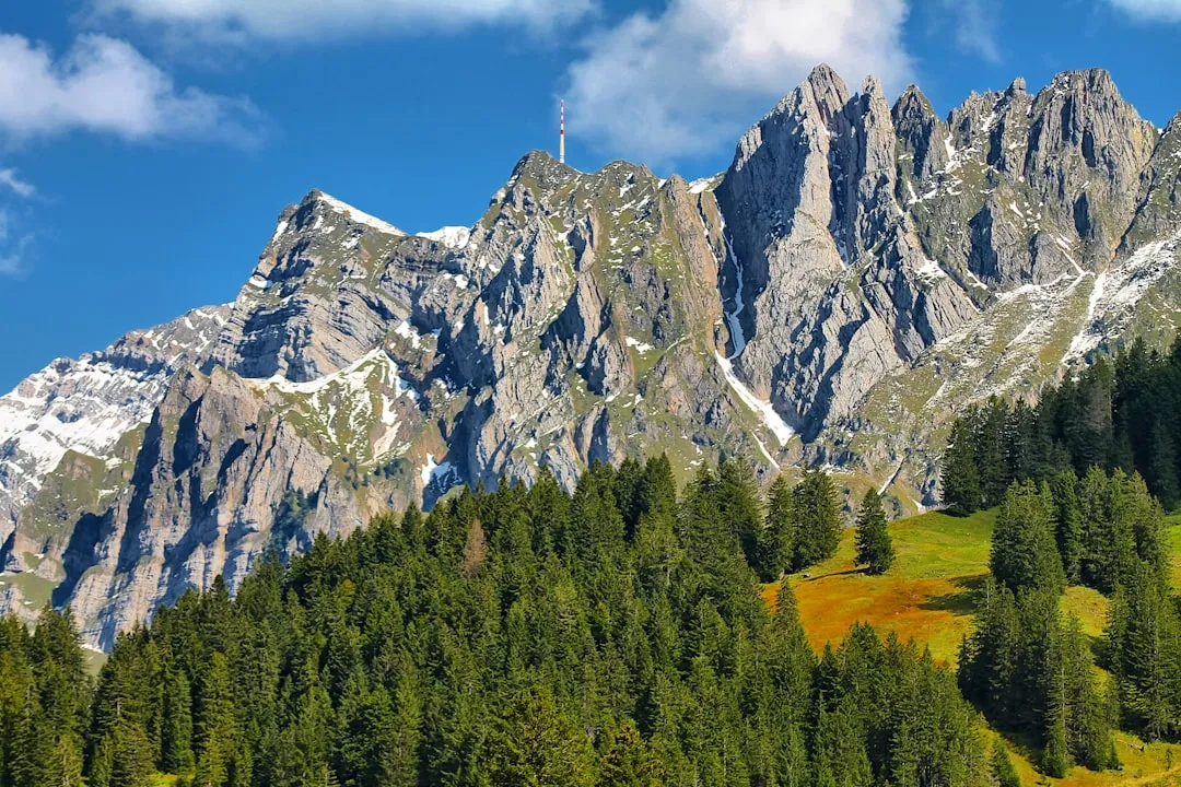
The Faulhornweg is a journey through some of the most spectacular alpine landscapes in Switzerland. Starting from the popular mountain station of First, accessible by gondola from Grindelwald, the trail immediately immerses you in a world of towering peaks and verdant alpine meadows. The path is generally well-trodden and clearly marked, winding its way across high mountain ridges and through alpine pastures dotted with wildflowers in summer. The highlight of the walk is undoubtedly the ascent to the summit of the Faulhorn, a prominent peak that offers an unparalleled 360-degree vista. From this vantage point, the iconic trio of the Eiger, Mönch, and Jungfrau dominate the skyline, their snow-capped summits piercing the blue sky. The descent to Schynige Platte continues to offer stunning views, with the turquoise waters of Lake Thun and Lake Brienz appearing in the distance as you lose elevation. The trail is a testament to the beauty and grandeur of the Swiss Alps, providing a memorable hiking experience for all who traverse it.
The route is a classic example of a high-alpine ridge walk, offering a balance of challenging ascents and rewarding descents. The terrain varies from wide, gravel paths to narrower, rocky sections, particularly as you approach the Faulhorn summit. The elevation gain is significant, but the well-constructed paths and the relatively short duration of the hike make it achievable for most moderately fit individuals. The presence of mountain restaurants and huts along the way provides opportunities for rest, refreshment, and soaking in the magnificent surroundings. The Faulhornweg is not just a walk; it's an immersion into the heart of the Bernese Alps, a place where nature's artistry is on full display.
History and Cultural Context
The region surrounding the Faulhornweg has a rich history deeply intertwined with alpine tourism and mountaineering. For centuries, the high pastures were used for grazing livestock, a practice that shaped the cultural landscape and contributed to the development of local traditions. The construction of mountain hotels and the establishment of hiking trails in the late 19th and early 20th centuries marked the beginning of modern alpine tourism in the Bernese Oberland.
The Faulhorn itself has been a destination for travellers for over 150 years. The first hotel on its summit was built in 1830, making it one of the oldest mountain hotels in the Alps. Its strategic location, offering commanding views of the surrounding peaks, quickly made it a popular spot for those seeking to experience the grandeur of the Alps. The development of the gondola lift to First in the mid-20th century further enhanced accessibility, transforming what was once a strenuous climb into a more manageable starting point for a spectacular day hike.
The trail connecting First to the Faulhorn and then down to Schynige Platte evolved from ancient paths and routes used by shepherds and early mountaineers. The meticulous maintenance of these paths, often through challenging terrain, reflects a long-standing commitment to preserving the alpine environment while facilitating access for visitors. Schynige Platte, the endpoint of the hike, is also historically significant, being the terminus of the cogwheel railway that has been transporting visitors up from Wilderswil since 1893. This railway itself is a marvel of engineering and a testament to the region's pioneering spirit in alpine tourism.
Seasonal Highlights and Weather Reality
The Faulhornweg is best enjoyed during the summer months when the snow has melted from the higher sections of the trail and the alpine meadows are in bloom. The primary hiking season typically runs from June to October.
June: Early June can still see lingering snow at higher elevations, especially on north-facing slopes. Wildflowers begin to appear, and the landscape is fresh and vibrant. The weather can be unpredictable, with a higher chance of late snow showers.
July and August: These are the peak months for hiking. The weather is generally warmer and more stable, although afternoon thunderstorms are common in the Alps. The alpine meadows are at their most colourful, bursting with a diverse array of wildflowers. This is also the busiest period, so expect more fellow hikers on the trail.
September: Autumn brings crisp, clear air and stunning golden hues to the alpine landscape. The crowds thin out, offering a more tranquil experience. The weather can be excellent, with long periods of sunshine, but temperatures begin to drop, and early snow is possible towards the end of the month.
October: The early part of October can still offer good hiking days, especially at lower elevations. However, the risk of significant snowfall increases, and mountain restaurants and huts may begin to close for the season. By mid-to-late October, the trail is often impassable due to snow.
Weather Reality: Alpine weather is notoriously changeable. Even in summer, conditions can shift rapidly from bright sunshine to heavy rain, fog, or even snow. Temperatures can drop significantly at higher altitudes, especially on the Faulhorn summit. It is crucial to be prepared for all eventualities, carrying appropriate layers of clothing and waterproof gear regardless of the forecast.
Recommended Itinerary
Faulhornweg Day Hike Itinerary
Early Morning: Travel to First
- Depart from Interlaken Ost by train to Grindelwald (approx. 35 minutes).
- From Grindelwald village, take the gondola up to First (approx. 25 minutes).
- Enjoy the initial views from First station and perhaps a brief exploration of the First Cliff Walk.
Morning: First to Bachalpsee
- Distance: 3.0 km
- Elevation gain: 150 m
- Time: 1 hour
- Begin the hike from First station, following well-marked signs towards Bachalpsee.
- The path is wide and relatively gentle, offering stunning views of the surrounding peaks.
- Arrive at the picturesque Bachalpsee, famous for its reflections of the Schreckhorn and Wetterhorn in its clear waters.
- This is an excellent spot for a short break and some initial photographs.
Late Morning: Bachalpsee to Faulhorn
- Distance: 4.0 km
- Elevation gain: 500 m
- Time: 1.5–2 hours
- Continue the ascent from Bachalpsee, the trail becoming steeper and more rugged as you climb towards the Faulhorn.
- The path winds through alpine meadows, offering increasingly expansive views.
- Pass by smaller tarns and rocky outcrops.
- The final approach to the Faulhorn summit involves a more direct climb.
- Arrive at the historic Berghotel Faulhorn (2,681 m), the highest point of the hike.
- Take ample time to enjoy the panoramic 360-degree views of the Eiger, Mönch, Jungfrau, and the surrounding Bernese Alps.
Midday: Lunch and Relaxation at Faulhorn
- Enjoy lunch at the Berghotel Faulhorn or a packed picnic with an unparalleled view.
- This is a prime opportunity to rest and absorb the magnificent alpine scenery.
Afternoon: Faulhorn to Schynige Platte
- Distance: 9.0 km
- Elevation loss: 650 m
- Time: 2.5–3 hours
- Begin the descent from the Faulhorn summit towards Schynige Platte.
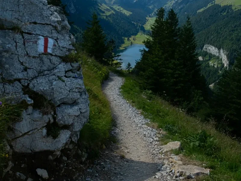
- The trail is well-maintained but can be steep in sections, requiring careful footing.
- Pass through alpine pastures and enjoy changing perspectives of the lakes below.
- The path gradually leads you towards the Schynige Platte ridge.
- Arrive at the Schynige Platte station, where you can admire the alpine garden and the historic cogwheel railway.
Late Afternoon: Descent from Schynige Platte
- Take the historic cogwheel railway down from Schynige Platte to Wilderswil (approx. 50 minutes).
- From Wilderswil, it's a short train ride back to Interlaken Ost.
Important Notes:
- Check the weather forecast and gondola/cogwheel railway operating times before you go.
- Wear sturdy hiking boots and carry layers of clothing, including waterproofs.
- Bring plenty of water and snacks, although refreshments are available at First, Faulhorn, and Schynige Platte.
- The trail is well-marked, but a map or GPS device is recommended.
Planning and Bookings
Book Your Trip
Everything you need to plan your journey
Accommodation
Find places to stay near Interlaken
Flights
Search flights to Interlaken
Essential Preparation
The Faulhornweg is a popular day hike, and while it doesn't require the extensive booking procedures of multi-day treks, careful planning is still essential for a smooth and enjoyable experience. The closest major transport hub is Interlaken, a well-connected town easily accessible by train from major Swiss cities like Zurich and Geneva. From Interlaken Ost, you will take a train to Grindelwald, the charming village that serves as the gateway to First. Parking is available in Grindelwald, but it is often fee-based, and the gondola station is easily accessible from the train station.
It is highly recommended to check the operating times and status of the gondola from Grindelwald to First and the cogwheel railway from Schynige Platte to Wilderswil, as these can vary seasonally and due to weather conditions. Purchasing tickets in advance, especially during peak season, can save time. Consider purchasing a Swiss Travel Pass or a regional pass if you plan on extensive train and cable car travel in Switzerland, as these can offer significant savings.
Trail Accommodation
This is a day hike requiring no overnight accommodation. However, there are significant hospitality options available at key points along the route:
- First: A mountain restaurant and various cafes are available at the top of the gondola station, offering meals and refreshments.
- Berghotel Faulhorn: This historic hotel is located at the summit of the Faulhorn and offers overnight stays for those wishing to experience a sunset and sunrise from this spectacular vantage point. It also has a restaurant serving meals and drinks. Booking accommodation at Berghotel Faulhorn is highly recommended, especially during peak season, as it is a popular destination.
- Schynige Platte: A restaurant and cafe are available at the top station of the cogwheel railway, providing refreshments before your descent.
Required Gear
- Hiking Boots: Sturdy, waterproof hiking boots with good ankle support are essential for navigating the varied terrain.
- Backpack: A comfortable daypack (20-30 litres) to carry essentials.
- Waterproof Jacket and Trousers: Lightweight, breathable waterproofs are crucial due to the unpredictable alpine weather.
- Warm Layers: Fleece or wool mid-layers, a hat, and gloves are recommended, as temperatures can drop significantly at higher altitudes.
- Sun Protection: High SPF sunscreen, sunglasses, and a wide-brimmed hat are necessary, as the sun's rays are intense at altitude, even on cloudy days.
- Navigation: A map of the area and a compass, or a GPS device/smartphone with offline maps. While the trail is well-marked, it's always wise to have backup navigation.
- First-Aid Kit: A basic kit including plasters, antiseptic wipes, pain relievers, and any personal medications.
- Head Torch: Useful in case of unexpected delays or for early morning starts.
What to Bring
- Water: At least 1.5-2 litres of water per person. Refill points are available at First and Schynige Platte, and potentially at Berghotel Faulhorn, but it's best to start well-hydrated.
- Food: Plenty of high-energy snacks (nuts, dried fruit, energy bars) and a packed lunch. The mountain restaurants offer meals, but they can be expensive, and it's good to have provisions.
- Toiletries: Hand sanitiser, tissues, and any personal hygiene items.
- Camera: To capture the incredible scenery.
- Walking Poles: Highly recommended, especially for the descent, to reduce strain on knees.
- Cash: While cards are widely accepted in Switzerland, it's wise to carry some Swiss Francs for smaller purchases or in case of card machine issues at remote locations.
Permits
No specific permits are required to hike the Faulhornweg. The trail is part of the public hiking network in Switzerland. However, access to the starting point at First is via a gondola lift, and the endpoint at Schynige Platte is accessed via a cogwheel railway. Tickets for these transport systems must be purchased.
Gondola from Grindelwald to First:
- Tickets can be purchased at the gondola station in Grindelwald.
- Prices vary depending on age and any applicable discounts (e.g., Swiss Travel Pass, Half Fare Card).
- Operating hours are seasonal and weather-dependent; always check in advance.
Cogwheel Railway from Schynige Platte to Wilderswil:
- Tickets can be purchased at the Schynige Platte station or in Wilderswil.
- This is a historic and scenic journey, and booking in advance is advisable during peak season.
- Operating hours are also seasonal and weather-dependent.
Berghotel Faulhorn: If you plan to stay overnight at the Berghotel Faulhorn, advance booking is essential. This can typically be done via their website or by contacting them directly. Prices for accommodation and meals should be checked with the hotel.
General Access: The trails themselves are free to use. The Swiss tradition of "right to roam" (though with responsibilities) means that public footpaths are generally accessible without charge.
Other Activities in the Area
The region around Grindelwald and Interlaken offers a wealth of activities for outdoor enthusiasts and those seeking relaxation:
- First Cliff Walk by Tissot: Located at the First gondola station, this thrilling walkway juts out from the side of a cliff, offering spectacular views and a unique perspective of the surrounding mountains.
- First Flyer and First Glider: For adrenaline seekers, these zip-line attractions offer a high-speed descent from First towards Schreckfeld and then back towards First, respectively.
- Mountain Cart and Trottibike Scooter: These fun downhill activities are available from First and Schreckfeld stations, offering an exciting way to descend part of the mountain.
- Hiking to Bachalpsee: As part of the Faulhornweg, but also a popular destination in its own right for shorter walks from First.
- Grindelwald-First Gondola Ride: Even without hiking, the scenic gondola ride offers magnificent views of the Eiger North Face and the surrounding valleys.
- Jungfraujoch – Top of Europe: A more extensive excursion, this train journey takes you to the highest railway station in Europe, offering glacier views and an ice palace.
- Lake Thun and Lake Brienz Cruises: Enjoy a leisurely boat trip on the stunning turquoise lakes, with views of charming lakeside villages and surrounding mountains.
- Paragliding and Hang Gliding: Interlaken is a world-renowned centre for paragliding, offering tandem flights with experienced instructors.
- Canyoning and Rafting: The rivers and gorges in the region provide opportunities for thrilling water-based adventures.
- Schynige Platte Alpine Garden: At the end of the hike, this garden showcases over 600 species of alpine plants from the Swiss Alps.
Safety and Conditions
Weather: Alpine weather is highly unpredictable. Always check the local mountain forecast (e.g., from MeteoSwiss or local tourist information) before setting out and be prepared for rapid changes. Conditions can vary significantly between the valley and the mountain peaks. Fog can descend quickly, reducing visibility to near zero, and temperatures can be much colder at higher altitudes.
Trail Conditions: The Faulhornweg is generally well-maintained and marked. However, sections can be steep, rocky, or exposed. In early season (June) or after heavy rain, some sections might be slippery or have minor snow patches. Always wear appropriate footwear with good grip.
Altitude: The highest point of the hike is the Faulhorn at 2,681 metres. While this is not extremely high, some individuals may experience mild altitude effects. Ascend gradually and stay hydrated.
Physical Fitness: The hike is rated as moderate. It involves significant elevation gain and loss over a considerable distance. A reasonable level of fitness is required. If you are not accustomed to hiking, consider shorter walks in the area first.
Navigation: While the trail is well-signposted, it is always advisable to carry a map and compass or use a reliable GPS device/app with offline maps. Familiarise yourself with the route before you start.
Emergency: In case of an emergency, contact the Swiss emergency number: 144 (ambulance) or 112 (general European emergency number). Mobile phone reception can be patchy in mountainous areas, so be aware of your location and try to stay in open areas if possible.
Sunburn and Dehydration: The sun's rays are stronger at higher altitudes. Use high SPF sunscreen, wear a hat and sunglasses, and drink plenty of water throughout the hike to prevent dehydration.
Respect Wildlife: Observe wildlife from a distance and do not feed any animals you encounter.
Side Trips and Points of Interest
Bachalpsee: While a waypoint on the main trail, Bachalpsee is a destination in itself. This stunning alpine lake is famous for its mirror-like reflections of the surrounding peaks, particularly the Schreckhorn and Wetterhorn, on calm days. It's an ideal spot for a picnic and photography.
First Cliff Walk by Tissot: Located at the First gondola station, this thrilling walkway extends from the cliff face, offering panoramic views and a unique perspective of the valley below. It's a short, accessible attraction that provides a dose of adrenaline and incredible photo opportunities.
Faulhorn Summit Views: The summit of the Faulhorn (2,681 m) is the absolute highlight of the hike. The 360-degree panorama encompasses the iconic Eiger, Mönch, and Jungfrau, as well as numerous other peaks of the Bernese Alps. On clear days, you can also see the lakes of Thun and Brienz far below. The historic Berghotel Faulhorn at the summit provides a perfect place to rest and soak in these unparalleled vistas.
Schynige Platte Alpine Garden: At the end of the hike, the Schynige Platte is home to a beautiful alpine garden showcasing over 600 species of native Swiss alpine plants. It's a delightful place to wander and learn about the local flora, offering a peaceful contrast to the rugged mountain scenery.
Historic Cogwheel Railway: The journey down from Schynige Platte on the cogwheel railway is an experience in itself. This beautifully preserved railway, operating since 1893, offers a nostalgic and scenic descent through alpine meadows and forests, providing a different perspective of the landscape.
Leave No Trace
The Faulhornweg traverses a pristine alpine environment, and it is crucial for all hikers to practice Leave No Trace principles to preserve its beauty and ecological integrity for future generations. The Bernese Alps are a fragile ecosystem, and even seemingly small impacts can have long-lasting effects.
Plan Ahead and Prepare: Research the trail, check weather forecasts, and be prepared for all conditions. This includes carrying appropriate gear and sufficient food and water.
Travel and Camp on Durable Surfaces: Stick to marked trails. Avoid walking on fragile vegetation, especially alpine meadows, which can take years to recover from damage. The paths are designed to withstand foot traffic; straying from them can cause erosion and harm plant life.
Dispose of Waste Properly: Pack out everything you pack in. This includes all food scraps, wrappers, and any other litter. Use designated waste bins where available, but if not, carry your rubbish with you until you can dispose of it properly. Do not bury waste, as it can be dug up by animals or leach into the soil.
Leave What You Find: Do not take rocks, plants, or any other natural objects from the environment. Leave them for others to enjoy and for the ecosystem to maintain itself.
Minimize Campfire Impacts: Campfires are generally not permitted on this day hike. If you were to camp (which is not recommended or permitted on this specific route), use established fire rings and ensure fires are completely extinguished.
Respect Wildlife: Observe animals from a distance. Do not feed them, as this can alter their natural behaviour, diet, and health. Keep pets under control if you bring them along (though dogs may have restrictions on certain transport systems).
Be Considerate of Other Visitors: Keep noise levels down, yield to other hikers on narrow sections of the trail, and be mindful of the experience of others. The goal is to enjoy the natural environment without negatively impacting it or the enjoyment of others.