Faroe Islands Coastal Trek - A Journey Through the Land of Maybe
The Faroe Islands Coastal Trek is a definitive North Atlantic odyssey, spanning 100 kilometres of rugged, emerald-green terrain across one of the world's most dramatic archipelagos. This 6-to-8-day journey is not a single continuous path in the traditional sense, but a curated sequence of ancient village-to-village cairn paths, dramatic cliff-side traverses, and steep mountain ascents that showcase the raw, unyielding beauty of the Faroese landscape. Starting in the historic capital of Tórshavn and weaving through the islands of Streymoy, Vágar, Eysturoy, and Kalsoy, the trek immerses walkers in a world where basalt cliffs plunge 500 metres into a churning ocean, and weather conditions change with such frequency that locals famously refer to their home as "Føroyar – the Land of Maybe."
Unlike many European long-distance trails, the Faroe Islands Coastal Trek demands a high degree of self-reliance and flexibility. There are no sprawling forests here; instead, the landscape is a minimalist masterpiece of treeless slopes, moss-covered volcanic rock, and thousands of cascading waterfalls that appear and disappear with the passing mists. The route follows the "varðar" (stone cairns) that have guided Faroese travellers for centuries, connecting isolated settlements that were, until the mid-20th century, only accessible by foot or boat. This is a journey through time as much as geography, offering a profound connection to a maritime culture that has survived on the edge of the habitable world for over a millennium.
- Distance: 100.0 km (total combined route)
- Duration: 6–8 days
- Season: June to September (optimal for light and weather)
- Elevation Gain: 3,000 m (cumulative)
- Difficulty: Moderate (requires navigation skills and weather resilience)
- Highest point: Slættaratindur (880 m)
- Base City: Tórshavn
- Accommodation: Guesthouses, hostels, and designated campsites
Overview
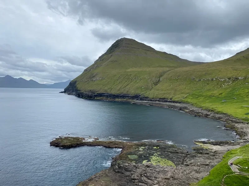
The Faroe Islands Coastal Trek is a masterclass in atmospheric hiking. The archipelago, located halfway between Norway and Iceland, consists of 18 volcanic islands characterised by steep, flat-topped mountains and narrow sounds. The trek is designed to link the most iconic coastal landscapes while utilising the islands' efficient ferry and tunnel network to transition between stages. The terrain is predominantly grass-covered peat and basalt rock, which can be deceptively spongy and wet even in the height of summer. Walkers should expect a mix of well-defined paths near villages and more obscure, pathless sections in the high moorlands where following the ancient stone cairns is essential for safety.
The visual scale of the Faroe Islands is difficult to capture in words. On the island of Vágar, you will walk alongside Sørvágsvatn, a lake that appears to perch precariously hundreds of metres above the ocean. On Streymoy, you will descend into the amphitheatre of Saksun, where a tidal lagoon is ringed by sheer cliffs and sod-roofed houses. The trek culminates in the northern isles, where the ridges become narrower and the drops more vertiginous. The geology here is a record of massive volcanic eruptions from 55 million years ago, with distinct layers of basalt and tuff creating a "staircase" effect on the mountainsides.
Wildlife is a constant companion on this route. The Faroe Islands are home to hundreds of thousands of Atlantic puffins, northern fulmars, and black guillemots that nest in the sheer sea cliffs. You will share the trails with the islands' most famous residents: the Faroese sheep. With a population exceeding 80,000, these hardy animals are the reason the islands were named "Føroyar" (Sheep Islands) in Old Norse. Their grazing keeps the landscape manicured and green, but their tracks can often mislead hikers, making a keen eye for the official cairns a vital skill.
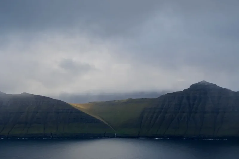
The experience is defined by the North Atlantic climate. The Gulf Stream ensures that the islands do not freeze, but it also brings constant moisture and unpredictable fog. One moment you may be basking in the golden light of the midnight sun, and the next, a thick "mjørki" (fog) can roll in from the sea, reducing visibility to a few metres. This volatility is part of the trek's character; it rewards those who are patient and well-prepared with some of the most ethereal light and landscape photography opportunities on the planet.
History and Cultural Context
The history of the Faroe Islands is etched into the very paths you will walk. The first settlers were likely Irish monks in the 6th century, followed by Norse Vikings in the 9th century. For over a thousand years, the "gøtur" (old paths) were the lifeblood of the islands. These trails were used by "tingmen" (representatives) travelling to the annual parliament in Tórshavn, by postmen carrying mail between isolated fjords, and by villagers transporting goods on their backs in "leypur" (wooden backpacks).
One of the most significant historical documents in the Faroes is the "Sheep Letter" (Seyðabrævið) of 1298, a medieval law code that regulated sheep farming and land use—laws that still influence the landscape today. As you trek, you will encounter "gerði" (stone walls) that have stood for centuries, separating the "innangarðs" (cultivated land near villages) from the "uttangarðs" (wild mountain pastures). These walls are a testament to the immense manual labour required to survive in this environment.
The cultural heart of the trek is found in villages like Kirkjubøur, which was the ecclesiastical centre of the islands in the Middle Ages. Here, you can see the ruins of the Magnus Cathedral and the Roykstovan, a 900-year-old farmhouse that is one of the oldest inhabited wooden houses in the world. The Faroese language itself is a treasure; it is a North Germanic tongue closely related to Old Norse, preserved through centuries of isolation and a rich tradition of oral storytelling and "kvæði" (ballad) dancing. Walking these trails is an act of retracing the steps of generations who lived by the rhythms of the sea and the seasons, maintaining a unique identity on the fringe of Europe.
Want more background? Read extended notes on history and cultural context → Learn more
Seasonal Highlights and Weather Reality
The Faroe Islands Coastal Trek is strictly a seasonal endeavour. While the islands are accessible year-round, the hiking conditions outside of the summer months are often treacherous due to high winds, heavy rain, and limited daylight.
Summer (June to August): This is the prime trekking window. June and July offer nearly 20 hours of daylight, allowing for long days on the trail and the magical experience of the "midnight twilight." This is also the peak breeding season for seabirds; the cliffs of Mykines and Skúvoy are teeming with puffins and gannets. While this is the "dry" season, rain is still frequent, but it is often interspersed with periods of brilliant clarity. Temperatures typically range from 10°C to 15°C.
Shoulder Season (May and September): May brings the awakening of the landscape, with bright green grass and the arrival of migratory birds, though snow can still linger on the higher peaks. September offers a shift in colour to deep ochres and browns, and the chance to see the first hints of the Aurora Borealis as the nights lengthen. However, the weather becomes significantly more unstable, with a higher frequency of Atlantic gales.
Winter (October to April): Trekking the full coastal route in winter is not recommended for most hikers. The islands experience intense storms with hurricane-force winds, and the mountain passes become icy and dangerous. Daylight is scarce—only 4 or 5 hours in late December—and many ferry services and local guesthouses operate on a reduced schedule. Winter in the Faroes is a time for coastal village stays rather than high-altitude trekking.
Regardless of the month, the "Faroe Fog" is a constant factor. It can appear in minutes, turning a straightforward ridge walk into a serious navigational challenge. Hikers must be prepared to wait out the fog or use GPS and compass skills to stay on the cairn-marked routes.
Recommended Itinerary
8-Day Faroe Islands Coastal Trek Itinerary
Day 1: Tórshavn to Kirkjubøur
- Distance: 7 km
- Elevation gain: 250 m
- Time: 2–3 hours
- Start in the capital, Tórshavn, and head over the Reynsmúli ridge
- Follow the well-marked cairn path with views of the islands of Sandoy, Hestur, and Koltur
- Arrive in Kirkjubøur, the islands' most important historical site
- Explore the Magnus Cathedral ruins and the 11th-century Saint Olav's Church
- Return to Tórshavn by local bus or stay in a local guesthouse
Day 2: Vágar Island - The Lake Above the Ocean
- Distance: 12 km
- Elevation gain: 300 m
- Time: 4–5 hours
- Transfer to Vágar Island (via sub-sea tunnel)
- Trek from Miðvágur along the shores of Sørvágsvatn (Leitisvatn)
- Reach the Bøsdalafossur waterfall where the lake drains into the Atlantic
- Ascend to the Trælanípa cliff (Slave Cliff) for the famous "optical illusion" view
- Continue coastal traverse towards the village of Sørvágur
Day 3: The Postman's Trail to Gásadalur
- Distance: 10 km
- Elevation gain: 450 m
- Time: 3–4 hours
- Follow the historic path over the mountain from Bøur to Gásadalur
- This was the only land access to the village until a tunnel was bored in 2004
- Steep ascent and descent with breathtaking views of Tindhólmur and Mykines
- Arrive in Gásadalur to see the iconic Múlafossur waterfall
- Stay overnight in Gásadalur or return to Sørvágur
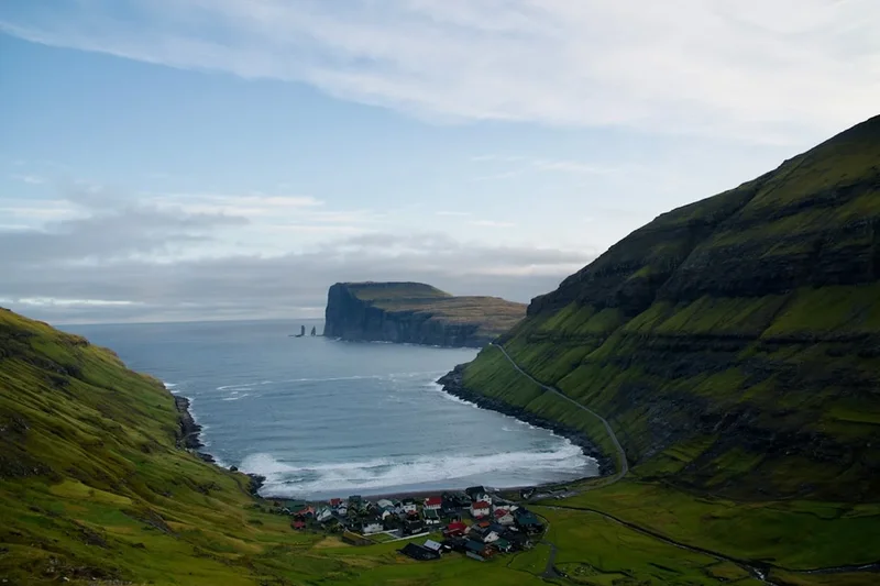
Day 4: Streymoy - Saksun to Tjørnuvík
- Distance: 15 km
- Elevation gain: 500 m
- Time: 5–6 hours
- Transfer to the remote village of Saksun
- Trek through the high mountain pass (Saksunardalur) towards the northern tip of Streymoy
- Descent into Tjørnuvík, a village nestled in a deep bay with a black sand beach
- Views of the "Giant and the Hag" (Risin og Kellingin) sea stacks
- This is one of the most classic and rugged cairn paths in the archipelago
Day 5: Eysturoy - The Roof of the Faroes
- Distance: 12 km
- Elevation gain: 880 m
- Time: 5–7 hours
- Transfer to the village of Gjógv, known for its natural sea gorge
- Ascend Slættaratindur, the highest mountain in the Faroe Islands
- On a clear day, you can see all 18 islands from the summit
- Descend towards Eiði or return to Gjógv for a night in the historic guesthouse
- Terrain is steep and requires good visibility
Day 6: Kalsoy - The Northern Ridges
- Distance: 14 km
- Elevation gain: 600 m
- Time: 5–6 hours
- Take the ferry from Klaksvík to Syðradalur on Kalsoy
- Trek the length of the island through the villages of Mikladalur (see the Seal Woman statue)
- Continue to Trøllanes and hike to the Kallur Lighthouse
- Experience the narrow "knife-edge" ridges that the northern isles are famous for
- Return to Klaksvík by evening ferry
Day 7: Borðoy - Klakkur and the Northern Isles
- Distance: 10 km
- Elevation gain: 400 m
- Time: 3–4 hours
- Hike from Klaksvík up to the ridge of Klakkur
- Panoramic views of Kunoy, Kalsoy, and the deep fjords of the north
- Afternoon exploration of Klaksvík, the second-largest town and fishing hub
- Optional side trip to the island of Kunoy for a forest walk (one of the few in the Faroes)
Day 8: The Final Coastal Stretch and Return
- Distance: 20 km (flexible)
- Elevation gain: 200 m
- Time: 5–6 hours
- Travel back to Streymoy for a final coastal walk near the village of Vestmanna
- View the famous bird cliffs from the clifftops
- Finish the trek with a celebratory meal in Tórshavn
- Reflect on a journey across the "Land of Maybe"
Planning and Bookings
Book Your Trip
Everything you need to plan your journey
Accommodation
Find places to stay near Tórshavn
Flights
Search flights to Tórshavn
Essential Preparation
The Faroe Islands Coastal Trek requires meticulous logistical planning, primarily due to the fragmented nature of the archipelago. While the islands are connected by an impressive network of sub-sea tunnels, bridges, and ferries, coordinating these with your hiking stages is vital. The national transport company, Strandfaraskip Landsins (SSL), operates all buses and ferries; purchasing a multi-day "Travel Card" is highly recommended for seamless transitions.
Fitness requirements are moderate to high. While the total elevation gain is 3,000 metres, the terrain is often pathless, boggy, and steep. You should be comfortable navigating with a GPS or map in low-visibility conditions. Tórshavn serves as the primary base for the start and end of the trek, offering the best selection of supermarkets and outdoor gear shops. It is advisable to book your first and last nights in Tórshavn well in advance, especially during the peak months of July and August.
Trail Accommodation
Accommodation in the Faroe Islands is a mix of hotels, guesthouses, hostels, and campsites. Because wild camping is strictly prohibited to protect the fragile environment and respect private landowners, you must plan your nights around designated locations.
Accommodation Types:
- Guesthouses: Found in villages like Gjógv, Gásadalur, and Kirkjubøur. These offer a traditional Faroese experience, often including breakfast. Prices range from 800 to 1,500 DKK per night.
- Hostels: Located in Tórshavn, Sandavágur, and Klaksvík. These are the most budget-friendly options, with dormitory beds and communal kitchens.
- Campsites: There are approximately 20 designated campsites across the islands. Facilities usually include toilets, showers, and sometimes a small kitchen. Note that many campsites are only for campervans, so verify tent availability beforehand.
- Hotels: Primarily in Tórshavn and Klaksvík, offering full amenities and higher comfort levels.
Booking Requirements: Summer is short and busy. Guesthouses in smaller villages often have limited rooms and can book out six months in advance. Always confirm ferry schedules, as some smaller islands (like Mykines or Kalsoy) have limited capacity and require advance booking for both transport and stay.
Required Gear
- Waterproof Jacket and Trousers: High-quality Gore-Tex or equivalent is non-negotiable. The rain is often horizontal and persistent.
- Hiking Boots: Sturdy, waterproof leather or synthetic boots with deep lugs. The terrain is frequently wet, muddy, and rocky.
- Navigation: A dedicated GPS device or a smartphone with offline maps (e.g., Gaia GPS or AllTrails). A physical map and compass are essential backups.
- Layers: Merino wool base layers and a warm mid-layer (fleece or synthetic down). Avoid cotton, which stays wet and cold.
- Backpack: A 35–50L pack with a high-quality rain cover.
- Trekking Poles: Highly recommended for stability on steep, slippery grass slopes and for testing the depth of boggy patches.
- Head Torch: Even with long summer days, a head torch is necessary for safety and for use in hostels or campsites.
What to Bring
- Food: While Tórshavn and Klaksvík have large supermarkets (Bónus or FK), smaller villages have very limited supplies. Carry at least two days of high-energy snacks and lightweight meals.
- Water Treatment: Faroese tap water is some of the purest in the world. Stream water in the mountains is generally safe, but a lightweight filter (like a Sawyer Squeeze) is recommended due to the high density of sheep.
- First Aid: Blister kits (Compeed), antiseptic wipes, and any personal medications.
- Sun Protection: The sun can be surprisingly strong when it appears, and the wind can mask the burn. Bring SPF 30+ and sunglasses.
- Power Bank: To keep your navigation devices charged, especially in cold or damp conditions which drain batteries faster.
- Dry Bags: To keep your clothes and electronics dry inside your pack.
Permits

Unlike many other Nordic countries, the Faroe Islands do not have a "Right to Roam" (Allemansrätten). Most of the land is privately owned by local farmers for sheep grazing. In recent years, a permit system has been introduced for several of the most popular hiking routes to manage the impact of tourism and compensate landowners.
Key Permit Areas:
- Trælanípa / Sørvágsvatn (Vágar): A fee of approximately 200 DKK per person is required to hike this trail. This can be paid at the trailhead kiosk.
- Mykines: A "hiking fee" is required for all visitors walking to the lighthouse to protect the puffin colonies. This must be paid online in advance.
- Saksun: A fee is required to walk across the beach to the lagoon.
- Villingardalsfjall (Viðoy): A fee is collected at the start of the trail for those climbing the mountain.
General Regulations: For most of the ancient cairn paths (the "gøtur"), there is currently no fee, but you are legally required to stay on the marked path. Walking off-trail is considered trespassing and can damage the fragile peat soil. If you are unsure, always ask for permission at the nearest farmhouse or check with the local tourist office (Visit Faroe Islands).
Guided Hikes: Some routes, particularly those that are technically difficult or pass through sensitive breeding grounds, are only accessible with a local guide. This is increasingly common in the northern isles and on Kalsoy.
Other Activities in the Area
The Faroe Islands offer a wealth of experiences beyond the trails. Consider these additions to your itinerary:
- Vestmanna Bird Cliffs: Take a boat tour from Vestmanna to see the towering 600-metre cliffs from below. The boats navigate through narrow sea caves and under massive arches, providing a unique perspective on the scale of the coastline.
- Sea Kayaking: Explore the calm fjords and hidden sea caves around Tórshavn or Klaksvík with a guided kayak tour.
- Faroese Horse Riding: Meet the unique Faroese horse, a small and hardy breed that was nearly extinct. Several stables offer treks through the hills near Tórshavn.
- Dining in Tórshavn: The capital has a burgeoning food scene. Experience "Heimablídni" (home hospitality) where locals open their homes for a traditional meal, or visit KOKS (when in residence), the islands' Michelin-starred restaurant.
- Fishing: The Faroes are a world-class destination for sea fishing. You can join a local boat for a few hours to catch cod, haddock, or saithe.
- Art and Culture: Visit the Listasavn Føroya (National Art Gallery) in Tórshavn to see how the dramatic landscape has inspired generations of Faroese painters.
Safety and Conditions
The "Land of Maybe" Weather: The single greatest danger in the Faroe Islands is the weather. Conditions can shift from sunshine to a total white-out of fog in less than ten minutes. If you are caught in the "mjørki" (fog) on a mountain ridge, the safest course of action is often to stay put and wait for it to clear, or use your GPS to follow your track back exactly. Never attempt to descend a steep slope in the fog, as many cliffs are sheer and hidden.
Cliff Edges: Many of the most beautiful views are from the tops of sea cliffs that drop hundreds of metres. The grass near the edge can be slippery, and sudden gusts of wind are common. Always maintain a safe distance from the edge, especially in windy conditions.
Emergency Services: The emergency number in the Faroe Islands is 112. However, mobile signal can be spotty in deep valleys or on remote northern ridges. It is highly recommended to carry a satellite messenger (like a Garmin inReach) if you are trekking solo.
Tide Awareness: For coastal sections like the Saksun lagoon or the walk to the Drangarnir sea stacks, you must be aware of the tide. Getting cut off by the rising Atlantic tide is a genuine risk. Always check local tide tables before setting out.
Sheep and Birds: While sheep are generally harmless, they can be protective of their lambs in the spring. More importantly, Arctic Terns are known to dive-bomb hikers who get too close to their nesting sites. If this happens, hold a stick or your trekking pole above your head; the birds will aim for the highest point.
Side Trips and Points of Interest
Drangarnir Sea Stacks: One of the most photogenic spots in the Faroes. This side trip from Sørvágur takes you along the coast to view the massive "Hole in the Rock" and the spire of Tindhólmur. This hike requires a guide as it passes through private land with sensitive sheep farming operations.
Mykines Lighthouse: A ferry trip to the westernmost island of Mykines is a must for bird lovers. The hike from the village to the lighthouse takes you through a massive puffin colony and across a footbridge over the Atlantic. Note that this island is often "weathered in," meaning ferries can be cancelled for days, so don't schedule this for the day before your flight home.
The Seal Woman of Mikladalur: On the island of Kalsoy, visit the statue of Kópakonan (the Seal Woman). The statue stands against the backdrop of the crashing waves and tells one of the islands' most famous and haunting legends.
Fossá Waterfall: Located on the way to Haldarsvík, this is the tallest waterfall in the Faroe Islands, dropping 140 metres in two stages. It is particularly impressive after heavy rain when the volume of water creates a thunderous roar that can be heard from kilometres away.
Tjørnuvík Surf: Even if you don't surf, watching the Atlantic swells roll into the black sand beach at Tjørnuvík is a meditative experience. The village is also famous for its "waffles and coffee" served in local homes.
Leave No Trace
The Faroe Islands are an ecologically sensitive environment. The thin layer of soil and the mossy vegetation take a long time to recover from damage. As tourism increases, the "Leave No Trace" principles are more important than ever to ensure the islands remain pristine.
Core Principles for the Faroes:
- Stay on the Path: This is the most important rule. Walking off-trail causes erosion and disturbs the nesting sites of ground-breeding birds like the whimbrel and golden plover.
- Respect Private Property: Remember that you are often walking on someone's livelihood. Close all gates behind you and never disturb the sheep.
- Pack Out All Trash: There are no bins on the trails. Carry all your rubbish, including organic waste like orange peels or apple cores, back to the villages.
- No Wild Camping: Use only designated campsites. This prevents the degradation of the landscape and protects water sources.
- Drones: Drone use is strictly regulated. It is prohibited near airports, in Tórshavn, and in many bird-nesting areas. Always check local regulations before flying.
- Human Waste: Use toilets in the villages before starting your hike. If you must go on the trail, ensure you are at least 50 metres from any water source and bury waste deep in the soil.