Everest Base Camp Trek - The Stairway to Heaven
The Everest Base Camp (EBC) trek is the ultimate pilgrimage for high-altitude hikers, a 130-kilometre round-trip journey that leads into the very heart of the Himalayas. Situated within the Sagarmatha National Park in north-eastern Nepal, this trek is far more than a physical challenge; it is a cultural immersion into the land of the Sherpa people and a front-row seat to the highest peaks on Earth. Starting from the dramatic mountain airstrip at Lukla, the trail winds through lush rhododendron forests, crosses precarious suspension bridges over the roaring Dudh Koshi River, and ascends through alpine meadows to the stark, glacial landscapes of the high Khumbu. Reaching the base of Mount Everest (8,848 metres) is a feat of endurance and acclimatisation, offering walkers the chance to stand at the foot of the world’s tallest mountain and witness the legendary Khumbu Icefall. This is a journey of profound scale, where the air grows thin, the prayer flags flutter in the biting wind, and every step reveals a landscape that has captivated explorers for over a century.
- Distance: 130 km (return trip)
- Duration: 12–14 days
- Season: March–May (Spring) and October–November (Autumn)
- Accommodation: Teahouses (mountain lodges)
- Highest point: Kala Patthar (5,545 m) or Everest Base Camp (5,364 m)
- Difficulty: Challenging (due to altitude and sustained ascent)
- Direction: Out-and-back (with various acclimatisation side-trips)
Overview
The Everest Base Camp trek is widely considered the gold standard of multi-day mountain adventures. Unlike many wilderness treks that require total self-sufficiency, the EBC route is supported by a unique network of "teahouses"—locally run lodges that provide food and shelter, allowing trekkers to carry lighter packs while supporting the local economy. However, the convenience of a bed and a hot meal does not diminish the difficulty of the terrain. The journey involves a total elevation gain of approximately 4,500 metres, much of it occurring in the "thin air" zone above 4,000 metres where oxygen levels are significantly lower than at sea level.
The landscape of the Khumbu region is one of dramatic contrasts. The lower sections of the trail, between Lukla (2,860 m) and Namche Bazaar (3,440 m), are surprisingly green, characterised by dense forests of pine, fir, and blooming rhododendrons. As you ascend, the vegetation thins, giving way to hardy shrubs and eventually a high-altitude desert of rock, ice, and moraine. The scale of the mountains is difficult to articulate; peaks like Thamserku, Ama Dablam, and Lhotse tower over the trail, their granite faces and ice-clad summits dominating the horizon. Ama Dablam, in particular, is often cited as the most beautiful mountain in the world, its distinctive "mother's necklace" shape visible for much of the middle section of the trek.
The cultural heartbeat of the trek is the Sherpa people. Originally migrants from Tibet, the Sherpas have developed a unique culture deeply intertwined with Vajrayana Buddhism and the mountains themselves. Along the trail, you will encounter countless Mani stones (stones carved with Buddhist mantras), colourful prayer flags sending blessings on the wind, and ancient monasteries like the one at Tengboche, where the morning chants of monks provide a spiritual soundtrack to the physical exertion of the climb. This is not just a walk to a mountain; it is a walk through a living museum of Himalayan heritage.
Wakahi Guide
Detailed route notes, maps, logistics & tips for the Everest Base Camp Trek (PDF).
History and Cultural Context
The history of the Everest Base Camp trek is inextricably linked to the history of Everest exploration itself. For centuries, the Khumbu region was a quiet enclave of Sherpa traders and farmers. This changed in the early 20th century when British expeditions began scouting the mountain from the Tibetan side. It wasn't until the 1950s, when Nepal opened its borders to foreigners, that the southern route to Everest became the primary focus of the mountaineering world.
The most pivotal moment in the trail's history occurred in 1953, when Sir Edmund Hillary and Tenzing Norgay Sherpa successfully reached the summit. Their expedition followed much of the same path that modern trekkers walk today, though they started their journey from the Kathmandu Valley, adding weeks of walking before even reaching the Khumbu. The construction of the Lukla airport in 1964—initiated by Hillary himself to facilitate the building of schools and hospitals for the Sherpa community—transformed the region. What was once a month-long expedition became a two-week trek, opening the "Roof of the World" to the global trekking community.
Culturally, the region is a stronghold of Tibetan Buddhism. The Sagarmatha National Park is considered a sacred landscape by the local population. The mountains are seen as the abodes of deities; Everest is known as Chomolungma ("Mother Goddess of the World") in Tibetan and Sagarmatha ("Goddess of the Sky") in Nepali. Respecting this spiritual heritage is a core part of the trekking experience. Walkers are expected to pass Mani walls and chortens (stupas) on the left side, following the clockwise direction of Buddhist circumambulation, and to seek permission before photographing religious ceremonies or interior monastery spaces.
Want more background? Read extended notes on history and cultural context → Learn more
Seasonal Highlights and Weather Reality
The trekking seasons in the Himalayas are dictated by the South Asian monsoon. There are two primary windows for trekking to Everest Base Camp, each offering a distinct experience.
Spring (March to May): This is the most popular time for those wishing to see the "climbing circus" at Base Camp. As the weather warms, hundreds of mountaineers set up their yellow tents on the Khumbu Glacier in preparation for summit attempts in May. The lower trails are spectacular during this time, as the rhododendron forests burst into shades of red, pink, and white. Temperatures are moderate at lower altitudes, though it remains cold at night above 4,000 metres. The air can be slightly hazier than in autumn, but the floral displays and the buzz of expedition energy make it a favourite for many.
Autumn (October to November): Following the monsoon, the air is washed clean of dust, resulting in the sharpest, clearest views of the peaks. This is widely considered the best time for photography. The weather is generally more stable, with crisp, blue-sky days. However, it is noticeably colder than spring, especially in November when temperatures at Gorak Shep can drop to -15°C or -20°C overnight. This is also the busiest season, so teahouses can be crowded.
Winter (December to February): Trekking is possible but requires extreme cold-weather gear and experience. Many teahouses at higher altitudes close, and the temperatures are brutal. However, the trails are empty, and the skies are often perfectly clear. High passes like the Cho La may be blocked by snow.
Monsoon (June to August): This is the least favourable time to trek. Heavy rain leads to muddy trails, leeches in the lower forests, and frequent flight cancellations to Lukla due to cloud cover. Most importantly, the great peaks are usually hidden behind thick clouds, depriving trekkers of the very views they came to see.
Recommended Itinerary
12-Day Everest Base Camp Itinerary
Day 1: Kathmandu to Lukla and Phakding
- Distance: 8 km
- Elevation: 2,860 m (Lukla) to 2,610 m (Phakding)
- Time: 3–4 hours
- Early morning flight from Kathmandu or Ramechhap to Lukla (Tenzing-Hillary Airport)
- The trek begins with a descent through the village of Lukla
- Pass through small Sherpa settlements and mani stone walls
- Cross the first of many suspension bridges over the Dudh Koshi River
- Arrive at Phakding for your first night in a teahouse
Day 2: Phakding to Namche Bazaar
- Distance: 11 km
- Elevation gain: 830 m
- Time: 6–7 hours
- Follow the river through pine forests, crossing the Hillary Suspension Bridge
- Enter Sagarmatha National Park at Monjo (permit check)
- A steep, sustained climb (the "Namche Hill") leads up to the Sherpa capital
- First view of Mount Everest from a rest point on the hill (weather permitting)
- Arrive in Namche Bazaar (3,440 m), a horseshoe-shaped village built into the mountainside
Day 3: Acclimatisation Day in Namche Bazaar
- Distance: 3–5 km (side trip)
- Elevation: Stay at 3,440 m (hike up to 3,880 m)
- Time: 3–4 hours
- Essential day to allow the body to adjust to the altitude
- Hike up to the Everest View Hotel for a panoramic vista of Everest, Lhotse, and Ama Dablam
- Visit the Sherpa Culture Museum and the Everest Photo Gallery
- Explore the local markets and bakeries in Namche
- Return to Namche for the night ("Walk high, sleep low")
Day 4: Namche Bazaar to Tengboche
- Distance: 10 km
- Elevation gain: 420 m (after a significant descent to the river)
- Time: 5–6 hours
- The trail contours around the mountain with spectacular views of Ama Dablam
- Descend to Phunki Thenga for lunch by the river
- A steep afternoon climb through rhododendron forest to the Tengboche ridge
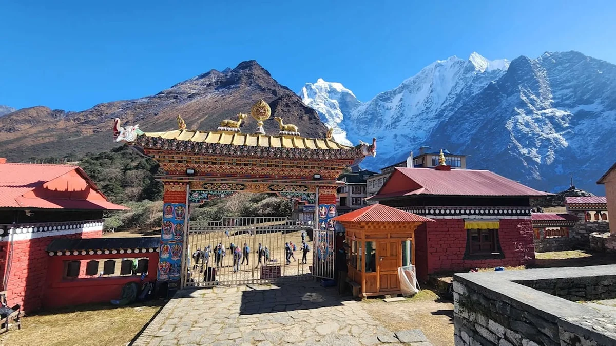
- Visit the famous Tengboche Monastery, the largest in the Khumbu region
- Evening views of Everest and Nuptse from the monastery grounds
Day 5: Tengboche to Dingboche
- Distance: 11 km
- Elevation gain: 540 m
- Time: 5–6 hours
- Descend through forest to Deboche, then cross the Imja Khola
- The landscape becomes noticeably more arid and alpine as you pass the tree line
- Walk past the village of Pangboche, home to one of the oldest monasteries in the region
- Arrive in Dingboche (4,410 m), a village surrounded by stone walls to protect crops from wind
Day 6: Acclimatisation Day in Dingboche
- Distance: 4–6 km (side trip)
- Elevation: Stay at 4,410 m (hike up to 5,100 m)
- Time: 3–5 hours
- Second mandatory acclimatisation day
- Hike up Nangkartshang Peak for incredible views of Makalu (the world's 5th highest peak) and the Imja Valley
- Rest in the afternoon to prepare for the final push to Base Camp
Day 7: Dingboche to Lobuche
- Distance: 8 km
- Elevation gain: 500 m
- Time: 5–6 hours
- Walk along the wide valley floor before a steep climb up the Thukla Pass
- At the top of the pass, visit the memorials for climbers who have perished on Everest
- The trail follows the lateral moraine of the Khumbu Glacier
- Arrive in Lobuche (4,910 m), a small settlement nestled under the peaks of Lobuche East and West
Day 8: Lobuche to Gorak Shep and Everest Base Camp
- Distance: 15 km (round trip from Gorak Shep)
- Elevation gain: 450 m
- Time: 7–9 hours
- A long, demanding day walking over rocky moraine to Gorak Shep (5,140 m)
- After a quick lunch, continue for 2–3 hours to Everest Base Camp (5,364 m)
- Stand on the Khumbu Glacier and witness the massive icefall
- Celebrate the achievement before returning to Gorak Shep for the night
Day 9: Gorak Shep to Kala Patthar and Pheriche
- Distance: 13 km
- Elevation: 400 m gain (Kala Patthar), then 1,200 m descent
- Time: 7–8 hours
- Pre-dawn climb to the summit of Kala Patthar (5,545 m) for the ultimate sunrise view of Everest
- Return to Gorak Shep for breakfast
- Begin the long descent back down the valley, passing through Thukla
- Arrive in Pheriche (4,240 m), a windy village home to the Himalayan Rescue Association clinic
Day 10: Pheriche to Namche Bazaar
- Distance: 14 km
- Elevation loss: 800 m
- Time: 6–7 hours
- Retrace your steps through Pangboche and Tengboche
- The descent is much faster as oxygen levels increase
- Re-enter the forest zone and enjoy the warmer air
- Arrive back in Namche Bazaar for a celebratory meal and perhaps a hot shower
Day 11: Namche Bazaar to Lukla
- Distance: 19 km
- Elevation loss: 580 m (with many ups and downs)
- Time: 7–8 hours
- The final long day of walking back to the Lukla airstrip
- Cross the suspension bridges one last time
- Arrive in Lukla and enjoy a final dinner with your guides and porters
Day 12: Lukla to Kathmandu
- Early morning flight back to Kathmandu
- Transfer to hotel and well-deserved rest
Important Notes:
- Itinerary includes two mandatory acclimatisation days; skipping these significantly increases the risk of AMS
- Flights to Lukla are highly weather-dependent; always build 2–3 buffer days into your international travel plans
- Distances and times are approximate and vary based on individual fitness and weather conditions
- The trek can be extended to include the Gokyo Lakes via the Cho La Pass (adds 4–5 days)
Planning and Bookings
Book Your Trip
Everything you need to plan your journey
Accommodation
Find places to stay near Kathmandu
Flights
Search flights to Kathmandu
Essential Preparation
The Everest Base Camp trek requires significant physical and logistical preparation. Physically, you should focus on cardiovascular endurance and leg strength. Training should begin at least 3–4 months before departure, incorporating long day hikes with a weighted pack, stair climbing, and aerobic exercises like running or cycling. While you don't need to be an elite athlete, the ability to walk for 6–8 hours a day for two weeks is essential.
Logistically, the most critical component is the flight from Kathmandu to Lukla. Due to congestion at Kathmandu’s Tribhuvan International Airport, many flights during the peak season (March–May and October–November) are diverted to Ramechhap Airport, which is a 4–5 hour drive from Kathmandu. You must coordinate your transport to Ramechhap and your flight booking simultaneously. It is highly recommended to use a reputable local trekking agency to handle these logistics, as they have the best access to flight updates and can assist with rebooking if weather delays occur.
Trail Accommodation
Accommodation on the EBC trek consists of "teahouses." These are simple, family-run lodges that have evolved from basic family homes into dedicated trekking hotels. While they offer a degree of comfort, they are not luxury hotels, and facilities become more basic as you gain altitude.
Hut Facilities:
- Twin-share rooms with two single beds and foam mattresses
- Common dining hall with a central wood or yak-dung burning stove (the only heated room)
- Shared toilets (squat toilets are common, though some lower lodges have western-style toilets)
- Basic blankets provided (but a high-quality sleeping bag is still essential)
- Electric charging for devices (available for a fee, usually US$2–$5 per full charge)
- Hot showers (available for a fee in lower villages, usually US$3–$7; higher up, it may be a bucket of hot water)
- WiFi (available via "Everest Link" cards, though speed and reliability are inconsistent)
What Teahouses Don't Provide:
- Toilet paper (must be purchased or brought with you)
- Towels and toiletries
- Heating in bedrooms (rooms are often near freezing at night)
- Free drinking water (bottled water is sold, but using a filter/tablets is more sustainable)
- Consistent electricity (power outages are common)
Booking Requirements:
- During peak season, teahouses in popular spots like Namche and Gorak Shep fill up quickly
- If trekking independently, you may need to arrive early in the afternoon to secure a room
- If trekking with a guide, they will usually call ahead to reserve rooms
- Costs: Rooms are relatively cheap (US$5–$10 per night) provided you eat your meals at the lodge. If you don't eat at the lodge, the room price may triple
Required Gear
- Hiking boots - waterproof, well-broken in, with good ankle support
- Down jacket - rated for -15°C or lower (essential for evenings and Kala Patthar)
- Sleeping bag - 4-season rated (comfort level -15°C), even with teahouse blankets
- Hard-shell waterproof jacket and trousers - breathable (Gore-Tex or similar)
- Trekking poles - essential for saving knees on the long descents
- Daypack - 30–40L for carrying water, layers, and snacks if using a porter
- Duffel bag - 80–100L if using a porter (must be durable and water-resistant)
- Head torch - with spare batteries (essential for the pre-dawn climb to Kala Patthar)
- Sunglasses - Category 4 (high altitude) to prevent snow blindness
- First aid kit - including Diamox (for altitude), antibiotics, and blister care
What to Bring
- Water purification - UV steriliser (SteriPEN) or purification tablets (avoid plastic bottles)
- Cash - Nepalese Rupees (NPR) are essential; there are no ATMs above Namche Bazaar
- Power bank - high capacity (20,000mAh+) to avoid expensive charging fees
- Snacks - energy bars, nuts, and chocolate (prices double or triple at high altitude)
- Toiletries - biodegradable soap, wet wipes (for "mountain showers"), and hand sanitiser
- Sun protection - SPF 50+ sunscreen and lip balm (the sun is incredibly strong at 5,000 m)
- Thermal layers - merino wool or synthetic base layers (avoid cotton)
- Fleece layers - mid-weight for trekking during the day
- Personal medications - including a broad-spectrum antibiotic and rehydration salts
- Entertainment - books, cards, or a Kindle for long afternoons in the teahouses
Permits
To trek to Everest Base Camp, you require two specific permits. The old "TIMS" (Trekkers' Information Management Systems) card system has largely been replaced in the Khumbu region by a local government permit, though requirements can change, so always check the latest regulations in Kathmandu.
1. Khumbu Pasang Lhamu Rural Municipality Entrance Permit:
- Cost: NPR 2,000 per person (approx. US$15)
- Where to get it: You can only obtain this in Lukla or Monjo. It cannot be purchased in Kathmandu
- Requirement: You will need your passport details
2. Sagarmatha National Park Entry Permit:
- Cost: NPR 3,000 per person (approx. US$23) plus 13% VAT
- Where to get it: At the National Park office in Kathmandu (Nepal Tourism Board) or at the park entrance gate in Monjo
- Requirement: Passport details and the fee in cash (NPR)
Important Permit Notes:
- Keep your permits in a waterproof bag and easily accessible in your daypack. There are multiple checkpoints along the trail (Monjo, Namche, and others) where you must register
- If you are planning to continue to the Gokyo Lakes or cross the Cho La Pass, no additional permits are required beyond these two
- If you are climbing a "trekking peak" like Island Peak or Lobuche East, you will need a separate climbing permit from the Nepal Mountaineering Association (NMA), which is significantly more expensive
- Always carry several passport-sized photos, as they are occasionally required for various forms or local SIM cards
Other Activities in the Area
The Khumbu region offers several world-class side trips and cultural experiences that can be integrated into your trek:
- Kala Patthar Climb: While often part of the standard itinerary, this 5,545 m peak is technically a side trip from Gorak Shep. It offers the most iconic view of Everest's summit, which is actually hidden from Base Camp itself by the West Ridge.
- Gokyo Lakes: A stunning alternative or extension to the EBC trek. These six turquoise, glacier-fed lakes are among the highest in the world. Crossing the Cho La Pass (5,420 m) connects the Gokyo Valley with the EBC trail.
- Ama Dablam Base Camp: A quieter side trip from Pangboche. It allows you to stand at the foot of the region's most beautiful mountain and see the climbing camps used for summit attempts.
- Khumbu International Library: Located in Namche Bazaar, this is a great place to spend an acclimatisation afternoon reading about the history of Himalayan exploration.
- Hillary School in Khumjung: Visit the school founded by Sir Edmund Hillary and see the "Yeti Scalp" kept in the Khumjung Monastery nearby.
- Helicopter Return: For those short on time or wanting a luxury finish, many trekkers opt to fly by helicopter from Gorak Shep or Lobuche directly back to Lukla or Kathmandu, offering a bird's-eye view of the route they just walked.
Safety and Conditions
Altitude Sickness (AMS): This is the single greatest risk on the Everest Base Camp trek. Acute Mountain Sickness (AMS) can affect anyone, regardless of age or fitness level. The key to prevention is a slow ascent. The standard itinerary includes two acclimatisation days for a reason—do not skip them. Symptoms include headache, nausea, dizziness, and loss of appetite. If symptoms persist or worsen, you must descend immediately. More severe forms, such as HAPE (High Altitude Pulmonary Edema) and HACE (High Altitude Cerebral Edema), are life-threatening and require immediate helicopter evacuation.
The "Khumbu Cough": The cold, dry air at high altitude can irritate the lungs, leading to a persistent, dry cough known as the Khumbu Cough. To prevent this, wear a buff or mask to warm and humidify the air you breathe, stay hydrated, and avoid overexertion.
Water Safety: Never drink untreated tap or stream water. Use a UV purifier, chlorine/iodine tablets, or a high-quality filter. Even "boiled" water in teahouses may not have reached a rolling boil for long enough at high altitude to kill all pathogens. Avoid ice in drinks in Kathmandu and Namche.
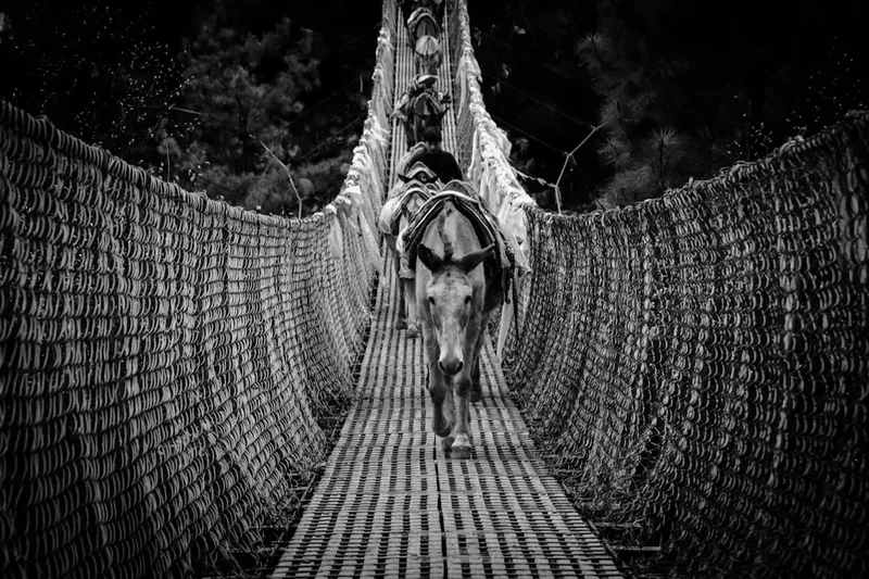
Animal Traffic: The trail is a highway for yaks, naks (female yaks), and dzo (yak-cow hybrids) carrying supplies. These animals always have the right of way. When a caravan approaches, always stand on the "mountain side" of the trail (away from the cliff edge) to avoid being accidentally bumped off the path.
Flight Safety: Lukla airport is famous for its short, sloped runway and challenging weather. Flights only operate in clear visibility. Be prepared for delays of several days. Always have travel insurance that covers "trip interruption" and "emergency heli-evacuation" up to 6,000 metres.
Side Trips and Points of Interest
Nangkartshang Peak: Located directly above Dingboche, this peak (5,083 m) is the perfect acclimatisation hike. The climb is steep but non-technical, and the reward is a spectacular view of the Imja Glacier, Island Peak, and the massive south face of Lhotse. It also provides one of the few spots where you can see the world's fifth-highest mountain, Makalu, in the distance.
The Everest Memorials: Located at the top of the Thukla Pass (4,830 m), this is a somber and moving site. Dozens of stone chortens have been built to honour climbers and Sherpas who have died on Everest. Among them are memorials for Scott Fischer and Rob Hall, made famous by the 1996 Everest disaster. It is a place for quiet reflection on the power and danger of the mountains.
Tengboche Monastery: Rebuilt twice (once after a fire and once after an earthquake), this monastery is the spiritual heart of the Khumbu. If you arrive in the afternoon, you may be able to witness the monks' prayer ceremony. The sight of the monastery with Everest and Ama Dablam in the background is one of the most photographed scenes in Nepal.
The Khumbu Glacier: As you approach Base Camp, you will walk alongside and eventually onto the Khumbu Glacier. This is the highest glacier in the world. You can hear the ice cracking and shifting beneath the rock debris—a reminder that the landscape is constantly in motion. The "Ice Pinnacles" near Base Camp are a surreal forest of frozen towers that must be seen to be believed.
Leave No Trace
The Everest region faces a significant waste management challenge due to its popularity and remoteness. As a trekker, you have a responsibility to minimise your impact on this fragile alpine environment. The "Sagarmatha Next" project and other local initiatives are working hard to clean up the mountain, but individual action is the first line of defence.
Your responsibility as a walker:
- Carry Out Your Trash: This includes "micro-trash" like candy wrappers and cigarette butts. If you bring it in, take it out. Many trekkers now participate in the "Carry Me Back" initiative, taking a small bag of shredded trash from Namche back to Lukla for proper disposal.
- Avoid Plastic Bottles: Millions of plastic water bottles are discarded in the Khumbu every year. Use a reusable bottle and treat your own water.
- Stay on the Trail: High-altitude vegetation is extremely slow-growing. Stepping off the trail can destroy plants that have taken years to establish.
- Respect the Wildlife: Do not feed or disturb Himalayan Tahrs, Danphe (monal pheasants), or musk deer.
- Manage Human Waste: Always use the toilets provided in teahouses. If you are caught short on the trail, bury waste at least 15 cm deep and 50 metres from water sources, and pack out your toilet paper.
- Conserve Energy: Wood is scarce at high altitudes. Do not ask for fires to be lit outside of the standard evening hours in the teahouse dining room.
The Himalayas are a gift to the world. By following Leave No Trace principles, you ensure that the "Stairway to Heaven" remains pristine for the generations of trekkers who will follow in your footsteps.