
Refuge des Espuguettes Loop: A Pyrenean Panorama
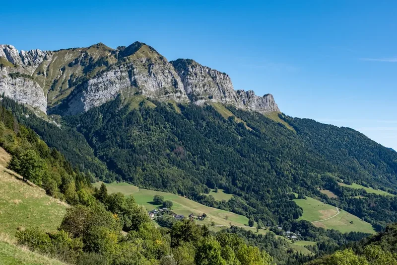
The Refuge des Espuguettes Loop is a spectacular day walk nestled in the heart of the French Pyrenees, offering breathtaking alpine scenery, challenging ascents, and a rewarding sense of accomplishment. This circular route, starting from the vicinity of Luz-Saint-Sauveur, takes you on a journey through diverse mountain landscapes, from verdant valleys to rugged, rocky terrain, culminating at the charming Refuge des Espuguettes perched high above the valley floor. It's a walk that demands a good level of fitness but rewards every step with unparalleled views of the surrounding peaks, including the iconic Pic du Midi de Bigorre.
- Distance: 11.5 km
- Elevation Gain: 700 m
- Duration: 5-6 hours
- Difficulty: Moderate
- Best Time: June to September
- Closest City: Luz-Saint-Sauveur
- Trailhead Access: Nearest airport: Tarbes-Lourdes-Pyrénées (LDE). Drive from Luz-Saint-Sauveur (approx. 15 min) towards Granges de Bué. Road is paved but narrow in sections. Limited parking available at trailhead. GPS: 42.8322, 0.1287. No permits required.
Overview
The Refuge des Espuguettes Loop is a quintessential Pyrenean experience, a day hike that packs a significant punch in terms of both physical exertion and visual splendour. The trail begins with a steady, sometimes steep, ascent from the trailhead, winding its way through alpine meadows and forests. As you gain altitude, the landscape opens up, revealing panoramic vistas that stretch across the Pyrenean range. The air becomes crisper, the vegetation changes, and the sense of being immersed in a wild, untamed environment intensifies.
The highlight of the walk is undoubtedly the Refuge des Espuguettes itself. This mountain refuge, a welcome sight for weary hikers, offers a tranquil spot to rest, refuel, and soak in the magnificent surroundings. From the refuge, the views are simply spectacular, encompassing a vast amphitheatre of peaks, including the imposing Pic du Midi de Bigorre, a renowned astronomical observatory. The descent follows a different path, often offering new perspectives and a varied terrain that keeps the journey engaging.
This loop is ideal for those seeking a challenging day hike that delivers a true taste of the high Pyrenees without the commitment of multi-day trekking. It’s a route that showcases the raw beauty of the mountains, the resilience of alpine flora, and the simple pleasure of reaching a summit and being rewarded with an unforgettable panorama. The moderate difficulty rating means it's accessible to reasonably fit hikers, but the significant elevation gain requires a good level of stamina and preparation.
History and Cultural Context
The area surrounding Luz-Saint-Sauveur and the Refuge des Espuguettes has a rich history deeply intertwined with pastoralism, pilgrimage, and the strategic importance of mountain passes. For centuries, these valleys have been traversed by shepherds guiding their flocks to high summer pastures, a tradition that continues to shape the landscape with well-worn trails and grazing lands.
The Refuge des Espuguettes itself is a testament to the enduring human desire to explore and inhabit these high mountain environments. Mountain refuges in the Pyrenees, like elsewhere in the Alps, emerged in the late 19th and early 20th centuries as infrastructure for mountaineers, hikers, and those seeking shelter in remote areas. They often began as simple stone structures, built by local communities or mountaineering clubs, providing basic accommodation and a focal point for mountain life.
The specific history of the Refuge des Espuguettes is tied to the development of tourism and mountaineering in the Hautes-Pyrénées. As access to the mountains improved, and as more people sought to experience the grandeur of the Pyrenean peaks, the need for such shelters became paramount. The refuge has likely undergone various renovations and expansions over the years to accommodate increasing numbers of visitors, while striving to maintain its authentic mountain character.
The region also holds significance for its connection to religious pilgrimage routes, particularly those leading to Lourdes, a major Catholic pilgrimage site located not far from Luz-Saint-Sauveur. While the Refuge des Espuguettes loop is primarily a recreational hike, the historical context of human passage and spiritual journeys through these mountains adds a deeper layer to the experience.
Seasonal Highlights and Weather Reality
The Refuge des Espuguettes Loop is best enjoyed during the warmer months when the trails are clear of snow and the weather is generally more stable. The period from June to September offers the most favourable conditions for this moderate-difficulty hike.
Spring (May): While some lower sections might be accessible, higher elevations can still hold significant snow, making the loop potentially impassable or requiring winter hiking experience and equipment. Wildflowers begin to bloom, adding colour to the meadows, but caution is advised.
Summer (June to August): This is the prime season. The trails are typically clear, the days are long, and the weather is generally pleasant, though afternoon thunderstorms are common in the mountains. The alpine meadows are in full bloom, creating a vibrant and picturesque landscape. The Refuge des Espuguettes is fully operational, offering a welcome respite and refreshments.
Autumn (September to October): September often provides excellent hiking conditions with crisp air, clear skies, and fewer crowds. The autumn colours can be stunning, with the foliage turning shades of gold and red. By late October, the risk of early snow increases, and temperatures begin to drop significantly, potentially making the hike more challenging or even impassable.
Weather: Mountain weather is notoriously unpredictable. Even during the summer months, conditions can change rapidly. Be prepared for sunshine, rain, wind, and a significant drop in temperature, especially at higher altitudes. Always check the local weather forecast before setting out and be ready to turn back if conditions deteriorate.
Recommended Itinerary
Refuge des Espuguettes Loop: A Day's Adventure
Early Morning: Trailhead and Ascent Begins
- Start from the designated trailhead parking area near Granges de Bué.
- Begin the steady ascent towards the Refuge des Espuguettes. The initial part of the trail often winds through pleasant woodland, offering shade and a gentle introduction to the climb.
- The path is well-marked but can be steep in sections, requiring a good pace and steady breathing.
Morning: Gaining Altitude and Panoramic Views
- As you climb higher, the trees begin to thin, and the landscape opens up.
- Enjoy increasingly expansive views of the surrounding Pyrenean valleys and peaks. This is a good time to pause for photos and to appreciate the scale of the landscape.
- The trail may cross open alpine meadows, dotted with wildflowers during the summer months.
Midday: Arrival at Refuge des Espuguettes
- Reach the Refuge des Espuguettes (approx. 1,960 m).
- Take a well-deserved break at the refuge. Enjoy a picnic lunch with a view, or purchase refreshments from the refuge if available.
- Soak in the magnificent 360-degree panorama. Key landmarks visible include the Pic du Midi de Bigorre, the Montagne Verte, and the vast expanse of the Pyrenean mountain range.
- Spend time exploring the immediate vicinity of the refuge, appreciating the high-alpine environment.
Afternoon: The Descent and Return Journey
- Begin the descent, following a different path to complete the loop.
- The descent route may offer different perspectives of the landscape you ascended, showcasing new angles and features.
- The terrain on the descent can vary, potentially including scree slopes or more technical sections, requiring careful footing.
- Continue descending through alpine meadows and potentially back into woodland as you approach the trailhead.
- Arrive back at the trailhead parking area, completing the loop.
Important Considerations:
- This is a demanding day hike with significant elevation gain. Ensure you are physically prepared.
- Carry sufficient water, as water sources may be limited or unreliable, especially in drier periods.
- Pack layers of clothing, as mountain weather can change rapidly.
- Wear sturdy hiking boots with good ankle support.
- Bring sun protection (hat, sunglasses, sunscreen) as the sun can be intense at altitude.
- A map and compass or GPS device are recommended for navigation, especially if visibility is poor.
Planning and Bookings
Book Your Trip
Everything you need to plan your journey
Accommodation
Find places to stay near Luz-Saint-Sauveur
Flights
Search flights to Luz-Saint-Sauveur
Essential Preparation
The Refuge des Espuguettes Loop is a day hike, meaning no overnight accommodation bookings are required. However, thorough preparation is crucial for a safe and enjoyable experience. The closest major town and logistical hub is Luz-Saint-Sauveur. This charming town offers a range of accommodation options, from hotels and guesthouses to campsites, catering to various budgets. It also provides essential services such as supermarkets for stocking up on supplies, outdoor gear shops for last-minute purchases, and restaurants and cafés for pre- or post-hike meals.
Access to the trailhead is primarily by car. The drive from Luz-Saint-Sauveur is approximately 15 minutes, taking you along a paved but narrow road towards Granges de Bué. Parking at the trailhead can be limited, especially during peak season, so arriving early is advisable. For those without a vehicle, local taxi services or pre-arranged transport from Luz-Saint-Sauveur are options, though less flexible.
Fitness is paramount. This hike involves a substantial elevation gain of 700 metres over 11.5 kilometres, equating to a sustained climb. Hikers should be comfortable with several hours of uphill walking and possess good cardiovascular fitness and leg strength. Familiarity with uneven terrain and potentially steep sections is also beneficial.
Trail Accommodation
This is a day hike requiring no overnight accommodation.
Required Gear
- Sturdy Hiking Boots: Waterproof and with good ankle support are essential for navigating varied terrain and providing stability on ascents and descents.
- Waterproof Jacket: A reliable waterproof and windproof jacket is crucial, as mountain weather can change rapidly, bringing rain and strong winds.
- Warm Layers: Even in summer, temperatures at altitude can be cool. Bring a fleece or insulating mid-layer, and a hat and gloves.
- Navigation Tools: A detailed map of the area, a compass, and/or a GPS device or smartphone with offline maps are highly recommended.
- First-Aid Kit: A well-stocked kit including blister treatment, pain relievers, antiseptic wipes, bandages, and any personal medications.
- Head Torch: Essential in case of unexpected delays or if starting very early or finishing late. Ensure it has fresh batteries.
- Sun Protection: High SPF sunscreen, sunglasses, and a wide-brimmed hat are vital due to the intensity of the sun at higher altitudes.
What to Bring
- Food: Plenty of high-energy snacks (nuts, dried fruit, energy bars) and a substantial packed lunch.
- Water: Carry at least 2-3 litres of water per person. While there might be streams, water treatment (filter or purification tablets) is strongly advised if you plan to refill.
- Toiletries: Biodegradable soap, toothbrush and toothpaste, hand sanitiser, and toilet paper.
- Personal Items: Mobile phone (for emergencies, though signal may be intermittent), camera, and a small backpack to carry everything.
- Trekking Poles: Highly recommended to reduce strain on knees during ascents and descents, and to improve balance.
- Insect Repellent: While not as notorious as some other mountain regions, biting insects can be present, especially near water sources or in sheltered areas.
Permits
No specific permits are required for hiking the Refuge des Espuguettes Loop. This is a public access trail within the French Pyrenees National Park. However, it is always advisable to check for any local regulations or temporary restrictions that may be in place, particularly concerning fire bans or access during specific events.
While no permits are needed for the hike itself, if you plan to stay overnight at the Refuge des Espuguettes (which is not part of this day hike itinerary but is an option for longer stays), you will need to make a reservation directly with the refuge. Reservations are highly recommended, especially during the peak summer season, as the refuge has limited capacity.
Refuge des Espuguettes Contact Information:
- It is best to search online for the most up-to-date contact details and booking procedures for the Refuge des Espuguettes, as these can change annually. Look for official websites or pages managed by local tourism boards or mountaineering federations.
General Park Regulations:
- Respect the natural environment: stay on marked trails, do not disturb wildlife, and pack out all litter.
- Camping is generally restricted to designated areas or campsites outside of the immediate vicinity of the refuge.
- Fires are typically prohibited in the high mountains to prevent wildfires.
Other Activities in the Area
The region around Luz-Saint-Sauveur and the Refuge des Espuguettes offers a wealth of activities for outdoor enthusiasts and those seeking cultural experiences:
- Pic du Midi de Bigorre: Ascend to the summit of the Pic du Midi (accessible by cable car from La Mongie or Bareges) for unparalleled astronomical observation facilities and breathtaking panoramic views of the Pyrenees. This is a must-do for any visitor to the region.
- Luz-Saint-Sauveur Exploration: Discover the historic town of Luz-Saint-Sauveur, with its Templar castle, medieval bridge, and thermal baths. It's a charming base for exploring the surrounding area.
- Thermal Spas: The area is renowned for its thermal springs. Luz-Saint-Sauveur and nearby towns like Barèges and Bagnères-de-Bigorre offer excellent spa facilities for relaxation and wellness.
- Other Hiking Trails: The Pyrenees offer an extensive network of hiking trails for all levels, from gentle valley walks to challenging multi-day treks. Explore routes to other mountain lakes, peaks, and refuges.
- Cycling: The mountain passes of the Pyrenees are legendary among cyclists, including famous Tour de France routes. Road cycling and mountain biking opportunities abound.
- Canyoning and Via Ferrata: For the more adventurous, the region offers opportunities for guided canyoning trips and via ferrata routes, providing thrilling ways to experience the mountain landscape.
- Paragliding: Experience the Pyrenees from a bird's-eye view with tandem paragliding flights, offering spectacular aerial perspectives.
Safety and Conditions
Pre-Hike Checks:
- Weather Forecast: Always check the most up-to-date mountain weather forecast for the Pyrenees region before you depart. Websites like Météo-France provide detailed forecasts for mountain areas. Be aware of potential for thunderstorms, especially in the afternoon during summer.
- Trail Conditions: While this is a popular day hike, conditions can vary. Check with local tourist information offices or the refuge itself for any recent updates on trail status, especially early or late in the season when snow might still be present.
- Road Access: Ensure the road leading to the trailhead is open and accessible. Narrow mountain roads can sometimes be affected by weather or maintenance.
On the Trail:
- Navigation: While the trail is generally well-marked, it is essential to carry a map and compass or a reliable GPS device. Visibility can drop rapidly in the mountains due to fog or cloud, making navigation difficult.
- Hydration and Nutrition: Carry more water than you think you will need, as dehydration can occur quickly at altitude. Pack high-energy snacks and a substantial lunch.
- Hypothermia Risk: Even on a warm day, temperatures can drop significantly at higher altitudes, especially with wind chill. Always carry extra layers of warm clothing, including a waterproof and windproof outer shell.
- Sun Exposure: The sun's rays are stronger at higher altitudes. Use high SPF sunscreen, wear a hat and sunglasses, and consider lip balm with SPF.
- Footwear: Ensure your hiking boots are well broken-in and provide adequate support. Blisters or ill-fitting footwear can ruin a hike.
- Emergency Contact: Inform someone of your hiking plans, including your intended route and expected return time. Carry a fully charged mobile phone, but be aware that mobile signal can be intermittent in mountainous areas. Consider carrying a personal locator beacon (PLB) for remote areas.
- Respect Wildlife: Observe wildlife from a distance and do not feed any animals.
Refuge des Espuguettes: If you plan to use the refuge for refreshments or an extended break, check its opening hours and services in advance, especially outside the main summer season.
Side Trips and Points of Interest
Pic du Midi de Bigorre Views: While not a side trip from the loop itself, the prominent presence of the Pic du Midi de Bigorre throughout the hike makes it a significant point of interest. Its distinctive observatory domes are visible from many points on the trail, serving as a constant reminder of the vastness of the Pyrenean range and the scientific endeavours taking place at its summit.
Alpine Flora and Fauna: The loop passes through diverse alpine environments, offering opportunities to observe a variety of plant and animal life. Keep an eye out for marmots, chamois (if you're lucky), and a colourful array of wildflowers such as gentians, edelweiss (though rare), and various alpine daisies during the summer months. The changing vegetation zones as you ascend and descend are a point of interest in themselves.
Geological Features: The Pyrenees are a geologically rich mountain range. As you hike, observe the rock formations, the evidence of glacial activity in the past (U-shaped valleys, moraines), and the general topography that has been shaped over millennia.
Panoramic Viewpoints: The entire loop is punctuated by numerous natural viewpoints. Each bend in the trail, each clearing in the trees, offers a new perspective on the surrounding mountains, valleys, and the distant plains. The area around the Refuge des Espuguettes itself is a prime example, offering a sweeping 360-degree vista.
Leave No Trace
The Refuge des Espuguettes Loop traverses a beautiful and sensitive mountain environment. Adhering to Leave No Trace principles is essential to preserve its natural beauty and ecological integrity for future visitors.
Plan Ahead and Prepare: Understand the trail, weather conditions, and any specific regulations before you go. Pack appropriately for the conditions you expect and for potential changes.
Travel and Camp on Durable Surfaces: Stick to the marked trails. Avoid cutting switchbacks, as this causes erosion and damages fragile vegetation. The trails themselves are the designated durable surfaces.
Dispose of Waste Properly: Pack it in, pack it out. This includes all food scraps, wrappers, and any other litter. Use the toilet facilities at the Refuge des Espuguettes if available, or dig a cathole at least 60 metres away from water sources, trails, and campsites if no facilities are present (though this is a day hike, so facilities are expected). Pack out all toilet paper.
Leave What You Find: Do not take any natural objects (rocks, flowers, plants) or cultural artifacts. Leave them for others to enjoy and for the ecosystem to thrive.
Minimise Campfire Impacts: Campfires are generally not permitted on this day hike. If you were to camp (which is not recommended or permitted in most areas outside designated sites), use a lightweight stove for cooking instead of a fire.
Respect Wildlife: Observe animals from a distance. Never feed them, as this can alter their natural behaviour and diet, and can be harmful to their health. Store food securely.
Be Considerate of Other Visitors: Keep noise levels down, yield to other hikers on narrow trails, and be mindful of others' enjoyment of the natural environment.