Enladrillado Plateau Hike
The Enladrillado Plateau Hike, nestled within Chile's Reserva Nacional Altos de Lircay, offers a captivating day walk through a landscape sculpted by ancient volcanic activity and the persistent forces of nature. This trail leads to a unique geological formation—a vast, flat expanse of basalt rock, resembling a paved courtyard, hence its name "Enladrillado" (paved). The hike is a journey through diverse ecosystems, from the fragrant pine forests of the lower slopes to the stark, exposed beauty of the high plateau, culminating in panoramic views of the surrounding Andes and the distant valleys. It's a moderate challenge, accessible to most reasonably fit hikers, and provides a profound sense of wilderness and geological wonder.
- Distance: 12.0 km return
- Duration: 4–6 hours
- Elevation Gain: 400 m
- Difficulty: Moderate
- Best Time: October to April (spring to autumn)
- Closest City: Talca
- Trailhead Access: Via Route K-115 east from Talca towards Vilches, then signs to Reserva Nacional Altos de Lircay. Approximately 2 hours driving.
Overview
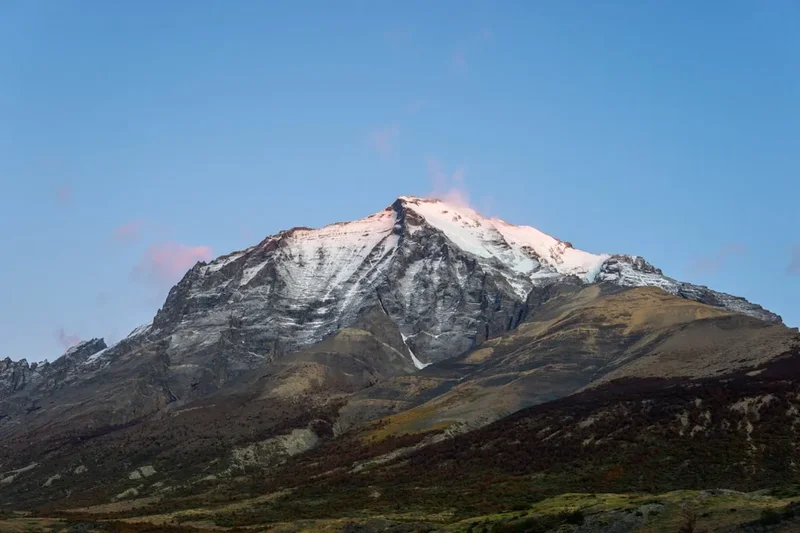
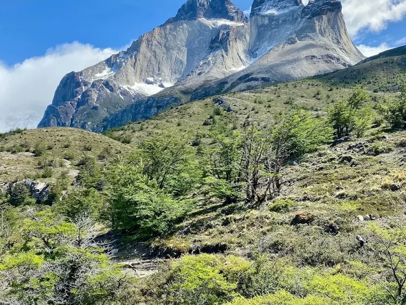
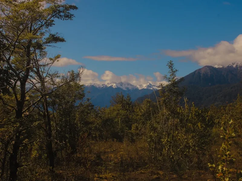
The Enladrillado Plateau Hike is a quintessential Patagonian experience condensed into a single day. The trail begins its ascent through the protected forests of Reserva Nacional Altos de Lircay, a region known for its endemic flora and fauna. As you climb, the vegetation gradually thins, giving way to more open terrain and eventually the striking, expansive basalt plateau. This flat, dark rock surface, formed by ancient lava flows, stretches out like a natural amphitheatre, offering a stark contrast to the lush forests below. The plateau itself is a place of quiet contemplation, where the wind whispers across the ancient stone and the sheer scale of the Andes unfolds before your eyes.
The hike is characterised by its steady, manageable climb. The initial section winds through fragrant pine forests, where the air is cool and shaded. As the elevation increases, the landscape opens up, revealing sweeping vistas of the surrounding mountains, including the imposing Volcán Quizapú. The final push leads to the plateau, a surreal and awe-inspiring environment. The flat, dark basalt is a geological marvel, a testament to the powerful volcanic forces that shaped this region millennia ago. Walking across this vast, natural pavement, with the sky stretching endlessly above and the rugged Andes as your backdrop, is an unforgettable experience.
The moderate difficulty level makes it an ideal choice for those seeking a substantial day hike without the commitment of an overnight trek. The 400 metres of elevation gain are spread out over the 6 km to the plateau, ensuring a consistent but not overly strenuous climb. The return journey offers a different perspective, allowing you to appreciate the descent and the changing light on the landscape. The best time to undertake this hike is during the spring and autumn months (October to April), when the weather is generally more stable and the temperatures are pleasant for walking.
History and Cultural Context
The region surrounding Reserva Nacional Altos de Lircay, and by extension the Enladrillado Plateau, has a rich history intertwined with the indigenous peoples of Chile and the geological forces that shaped the Andes. For centuries, these lands were traversed by indigenous groups, who understood the rhythms of the mountains and the bounty of the forests. While specific historical records detailing the use of the Enladrillado Plateau by these early inhabitants are scarce, it is highly probable that they utilized the area for hunting, gathering, and as part of seasonal migration routes, given its strategic location and the resources it offered.
The geological history of the Enladrillado Plateau is a story of immense volcanic power. The plateau itself is a product of ancient basaltic lava flows that spread across the landscape, cooling and solidifying into the distinctive flat, paved-like surface. These flows are part of the broader volcanic activity that has characterised the Andes mountain range for millions of years. The nearby Volcán Quizapú, a stratovolcano, has been a significant source of volcanic activity in the region, with its eruptions shaping the very ground beneath your feet.
In more recent history, the area has been recognised for its ecological and geological significance, leading to the establishment of Reserva Nacional Altos de Lircay. This designation aims to protect the unique ecosystems, including the native pine forests (Pinus radiata and Araucaria araucana), and the fragile alpine environments. The creation of the national reserve has allowed for the preservation of these natural wonders, making them accessible to hikers and nature enthusiasts while ensuring their long-term protection. The Enladrillado Plateau, as a prominent geological feature within the reserve, stands as a silent monument to the earth's dynamic past.
Seasonal Highlights and Weather Reality
The Enladrillado Plateau Hike is best experienced during the warmer months, from October to April, which correspond to spring, summer, and early autumn in the Southern Hemisphere. During this period, the weather is generally more favourable for hiking, with milder temperatures and a lower chance of heavy snowfall or extreme cold.
Spring (October to November): This is a beautiful time to visit as the landscape awakens from winter. Wildflowers begin to bloom, adding splashes of colour to the meadows and lower slopes. The pine forests are vibrant, and the air is crisp and clean. However, early spring can still bring unpredictable weather, including late frosts or occasional snow showers at higher elevations. Temperatures can range from 5°C to 15°C.
Summer (December to February): Summer offers the warmest temperatures, typically ranging from 15°C to 25°C, and the longest daylight hours. This is the most popular time for hiking, and the plateau can be busy. The weather is generally more stable, but afternoon thunderstorms are not uncommon in the Andes, so it's wise to start your hike early. The plateau can become quite warm under direct sun, so adequate sun protection is essential.
Autumn (March to April): Autumn brings a spectacular display of changing colours to the forests, with the pine needles and surrounding vegetation taking on golden and reddish hues. The temperatures begin to cool, ranging from 5°C to 15°C, and the crowds thin out. The air is often clear, offering excellent visibility for panoramic views. However, as autumn progresses, the risk of early snow increases, particularly towards the end of April.
Winter (May to September): While the Reserva Nacional Altos de Lircay is technically open year-round, hiking to the Enladrillado Plateau during winter is generally not recommended for casual day hikers. The trail can be covered in snow and ice, making it treacherous and requiring specialised winter hiking equipment and experience. Temperatures can drop well below freezing, and heavy snowfall can make the route impassable. Access roads may also be affected by snow.
Weather Considerations: Regardless of the season, mountain weather is notoriously unpredictable. Be prepared for rapid changes, including sudden drops in temperature, strong winds, and rain, even on seemingly clear days. Always check the weather forecast before you go and be ready to turn back if conditions deteriorate.
Recommended Itinerary
Enladrillado Plateau Day Hike Itinerary
Early Morning (Approx. 8:00 AM): Departure from Talca
- Begin your journey from Talca, heading east on Route K-115 towards Vilches.
- The drive takes approximately 2 hours, transitioning from paved roads to gravel as you approach the national reserve.
- Enjoy the changing scenery as you leave the city behind and enter the foothills of the Andes.
Morning (Approx. 10:00 AM): Arrival at Reserva Nacional Altos de Lircay
- Arrive at the park entrance. Pay the entrance fee and register your visit at the ranger station.
- Locate the designated parking area near the trailhead.
- Take a moment to prepare your gear, apply sunscreen, and ensure you have sufficient water.
- Begin the hike from the trailhead.
Late Morning to Midday (Approx. 10:30 AM - 1:00 PM): Ascent through Forests and Open Terrain
- The trail begins with a gentle to moderate ascent through fragrant pine forests.
- Enjoy the shade and the sounds of nature. Keep an eye out for local birdlife.
- As you gain elevation, the forest begins to thin, and the terrain opens up.
- The path becomes more exposed, offering increasingly impressive views of the surrounding mountains, including Volcán Quizapú.
- The elevation gain is steady, building your fitness for the final push.
Midday (Approx. 1:00 PM - 2:00 PM): Arrival at Enladrillado Plateau
- Reach the summit of the hike: the Enladrillado Plateau.
- Spend time exploring this unique geological formation. Walk across the vast, flat basalt surface.
- Take in the breathtaking 360-degree panoramic views of the Andes mountain range.
- Find a comfortable spot to enjoy your packed lunch and rehydrate.
- This is an excellent opportunity for photography, capturing the stark beauty of the plateau and the surrounding peaks.
Afternoon (Approx. 2:00 PM - 4:00 PM): Descent and Return Journey
- Begin your descent back towards the trailhead.
- The downhill section can be steep in places, so take care with your footing.
- The changing light on the landscape offers a new perspective on the scenery you encountered on the way up.
- Continue through the open terrain and back into the pine forests.
Late Afternoon (Approx. 4:00 PM - 4:30 PM): Return to Trailhead and Vehicle
- Arrive back at the trailhead and your parked vehicle.
- Take time to stretch and reflect on your hike.
Evening (Approx. 4:30 PM onwards): Departure from Reserve and Return to Talca
- Begin your drive back to Talca.
- The return journey offers a chance to relax and reminisce about the day's adventure.
Important Notes:
- This is a day hike; no overnight accommodation is required.
- Carry all necessary food, water, and supplies.
- Be prepared for changing weather conditions.
- Respect the natural environment and follow Leave No Trace principles.
- Check park opening hours and any specific regulations before your visit.
Planning and Bookings
Book Your Trip
Everything you need to plan your journey
Accommodation
Find places to stay near Talca
Flights
Search flights to Talca
Essential Preparation
The Enladrillado Plateau Hike is located within Reserva Nacional Altos de Lircay, a protected area managed by CONAF (Corporación Nacional Forestal). Planning your visit involves understanding access, park regulations, and ensuring you have the necessary gear for a day hike in a mountainous environment.
Base Town: Talca
Talca is the closest major city to Reserva Nacional Altos de Lircay and serves as the primary logistical hub. Talca offers a range of accommodation options, from budget hostels to mid-range hotels, as well as supermarkets for purchasing food and supplies, and outdoor gear shops for any last-minute necessities. It is also the starting point for the drive to the reserve.
Logistics and Access:
Access to the trailhead is via Route K-115, a road that leads east from Talca towards Vilches. As you get closer to the reserve, the road transitions from paved to gravel. The drive takes approximately 2 hours. It is advisable to have a vehicle capable of handling unpaved roads, although a standard car can usually manage in good weather conditions. Ensure your vehicle is in good working order before embarking on the journey. Parking is available at the park entrance or designated areas near the trailhead.
Park Entrance and Fees:
Upon arrival at Reserva Nacional Altos de Lircay, you will need to pay an entrance fee and register your visit at the CONAF ranger station. It is recommended to check the current entrance fees and opening hours on the official CONAF website or by contacting the park administration in advance, as these can change.
Fitness Requirements:
The hike is classified as moderate, involving a steady ascent of 400 metres over approximately 6 kilometres to the plateau. A reasonable level of cardiovascular fitness is required. Hikers should be comfortable walking for 4-6 hours, including uphill sections. Prior experience with day hiking is beneficial.
Trail Accommodation
This is a day hike requiring no overnight accommodation.
Required Gear
- Sturdy Hiking Boots: Waterproof and with good ankle support are essential for navigating uneven terrain and potential wet conditions. Ensure they are well broken-in to prevent blisters.
- Backpack: A comfortable daypack (20-30 litre capacity) to carry your essentials.
- Waterproof Jacket: A breathable, waterproof outer layer is crucial, as mountain weather can change rapidly.
- Warm Layers: Even in summer, temperatures can drop significantly at higher elevations. Bring a fleece or insulating jacket, and a hat and gloves.
- Sun Protection: High SPF sunscreen, sunglasses, and a wide-brimmed hat are vital, especially on the exposed plateau.
- Navigation Tools: A map of the area, a compass, and a GPS device or smartphone with offline maps downloaded are recommended. While the trail is generally well-marked, it's always wise to be prepared.
- First-Aid Kit: A comprehensive kit including bandages, antiseptic wipes, pain relievers, blister treatment, and any personal medications.
- Head Torch: Essential in case of unexpected delays or if you start very early or finish late.
What to Bring
- Food: Sufficient high-energy snacks and a packed lunch for the duration of the hike. Consider items like trail mix, energy bars, sandwiches, and fruit.
- Water: Carry at least 2 litres of water per person. There are no reliable water sources on the plateau itself, and stream water lower down should be treated.
- Water Treatment: A water filter or purification tablets are recommended if you plan to refill from streams lower down the trail.
- Toiletries: Biodegradable toilet paper, hand sanitiser, and a small trowel for burying human waste if necessary (though facilities may be available at the park entrance).
- Insect Repellent: Depending on the season, insects can be present.
- Camera: To capture the stunning scenery.
- Trekking Poles (Optional): Can be helpful for stability on ascents and descents, especially on steeper sections.
- Small Binoculars (Optional): For wildlife viewing.
Permits
To hike the Enladrillado Plateau, you will need to pay an entrance fee to Reserva Nacional Altos de Lircay. This fee contributes to the conservation and maintenance of the park.
Entrance Fees:
- Fees are typically paid at the CONAF ranger station upon arrival at the park.
- It is advisable to check the current fee structure on the official CONAF website or by contacting the park administration prior to your visit, as these can be subject to change.
- Prices are generally modest for day visitors.
Registration:
- All visitors are required to register their visit at the ranger station. This helps CONAF monitor visitor numbers and provides essential information in case of emergencies.
- You may be asked to provide details about your planned route and expected return time.
No Special Permits Required for Day Hiking:
For a standard day hike to the Enladrillado Plateau, no special permits beyond the park entrance fee are typically required. However, if you plan any activities outside of standard day hiking, such as overnight camping (if permitted in designated areas), or research, you would need to inquire with CONAF about specific regulations and potential additional permits.
Booking in Advance:
While not usually necessary for day hikes, during peak season or for specific events, it might be prudent to check if any advance booking is recommended or required, especially for vehicle access or if you are travelling during a public holiday period in Chile.
Other Activities in the Area
Reserva Nacional Altos de Lircay and its surroundings offer several other opportunities for exploration and enjoyment:
- Laguna del Alto: A beautiful high-altitude lake accessible via a separate trail within the reserve. It offers stunning reflections of the surrounding mountains and is a popular spot for photography.
- Valle del Francés: Explore other valleys within the reserve that offer different hiking experiences and unique flora and fauna.
- Volcán Quizapú: For experienced mountaineers with appropriate gear and knowledge, ascents of nearby volcanoes like Volcán Quizapú can be undertaken, though these are significantly more challenging than the Enladrillado Plateau hike.
- Birdwatching: The diverse ecosystems of the reserve are home to a variety of bird species, including woodpeckers, condors (if you're lucky), and various smaller forest birds.
- Photography: The dramatic landscapes, from the dense forests to the stark plateau and volcanic peaks, provide endless opportunities for landscape photography.
- Picnicking: Designated picnic areas are available within the reserve, offering pleasant spots to relax and enjoy the natural surroundings.
- Exploring Vilches: The small town of Vilches, located on the route to the reserve, offers a glimpse into rural Chilean life and may have local crafts or food options.
Safety and Conditions
Weather Preparedness:
- Mountain weather is highly variable. Always check the forecast for Talca and the specific mountain region before you depart.
- Be prepared for sudden changes: strong winds, rain, fog, and a significant drop in temperature are possible, even on sunny days.
- Carry layers of clothing, including waterproof and windproof outer shells.
Trail Conditions:
- The trail to the Enladrillado Plateau is generally well-maintained but can be uneven, rocky, and steep in sections.
- After rain, parts of the trail may become muddy or slippery.
- The plateau itself is a vast, open area. While flat, it is exposed to the elements.
Navigation:
- While the main trail is usually clear, it is essential to carry a map and compass and know how to use them. A GPS device or smartphone with offline maps is highly recommended.
- Do not rely solely on mobile phone signal, as it is often unreliable in remote areas.
Water and Food:
- Carry sufficient water (at least 2 litres per person) as there are no reliable water sources on the plateau.
- Treat any water collected from streams lower down the trail before consumption.
- Bring enough high-energy food to sustain you throughout the hike, plus extra in case of delays.
Wildlife:
- Be aware of local wildlife. While encounters are rare, it's important to maintain a safe distance and never feed animals.
- Insects, such as mosquitoes or horseflies, can be present, especially during warmer months.
Emergency Procedures:
- Inform someone of your hiking plans, including your expected return time.
- Carry a fully charged mobile phone, but be aware that reception is limited. A personal locator beacon (PLB) is a valuable safety device for remote areas.
- Know the emergency contact number for CONAF or local emergency services in Chile.
Physical Fitness:
- Ensure you are physically prepared for a moderate hike with significant elevation gain.
- If you have any pre-existing medical conditions, consult your doctor before undertaking the hike.
Side Trips and Points of Interest
Volcán Quizapú Views: While not a direct side trip from the Enladrillado Plateau trail itself, the imposing presence of Volcán Quizapú is a constant feature of the landscape. On a clear day, the views of this active volcano from the plateau are spectacular. Its dramatic slopes and the surrounding volcanic terrain are a testament to the region's geological past.
Forest Trails: Before reaching the open plateau, the trail winds through beautiful native pine forests. Take time to explore some of the smaller, less-defined paths that branch off the main route (with caution and good navigation skills). These offer a chance to immerse yourself in the quieter, shaded environment and observe the diverse plant life.
Geological Formations: The Enladrillado Plateau itself is the primary point of interest. Its vast, flat expanse of dark basalt rock, formed by ancient lava flows, is a unique geological phenomenon. Look closely at the texture and patterns of the rock, which reveal the story of its fiery origins. The edges of the plateau often feature interesting rock formations and scree slopes.
Panoramic Viewpoints: Along the ascent and descent, numerous points offer breathtaking panoramic views of the surrounding Andes mountain range. These viewpoints are ideal for pausing, taking photographs, and appreciating the sheer scale and beauty of the landscape. Keep an eye out for the distant valleys and the winding path of the road you travelled.
Flora and Fauna Spotting: The transition from forest to alpine environment provides opportunities to observe different species of plants and animals. Look for native trees, shrubs, and wildflowers, and listen for the calls of birds. While wildlife sightings are not guaranteed, the reserve is home to a variety of species.
Leave No Trace
The Reserva Nacional Altos de Lircay is a precious natural environment, and it is crucial for all visitors to practice Leave No Trace principles to preserve its beauty and ecological integrity for future generations.
Plan Ahead and Prepare:
- Research the trail, weather conditions, and park regulations before your visit.
- Pack appropriate gear and sufficient supplies to avoid needing to forage or leave waste behind.
- Be aware of any fire restrictions in place.
Travel and Camp on Durable Surfaces:
- Stay on the marked trails at all times. This prevents erosion and protects fragile vegetation.
- The Enladrillado Plateau is a durable surface, but avoid disturbing the rock formations unnecessarily.
Dispose of Waste Properly:
- Pack it in, pack it out. This includes all food scraps, wrappers, and any other litter.
- Use designated toilet facilities if available at the park entrance. If not, dig a cathole at least 60 metres away from water sources, trails, and campsites, and bury human waste and toilet paper.
Leave What You Find:
- Do not remove any natural objects, such as rocks, plants, or flowers.
- Leave the landscape as you found it for others to enjoy.
Minimise Campfire Impacts:
- Campfires are generally not permitted on day hikes and are often restricted within national parks. Check park regulations regarding fires. If permitted, use designated fire rings and ensure fires are completely extinguished.
Respect Wildlife:
- Observe wildlife from a distance. Never feed animals, as this can disrupt their natural behaviours and diets.
- Store food securely to prevent attracting animals.
Be Considerate of Other Visitors:
- Keep noise levels down to allow everyone to enjoy the natural environment.
- Yield to other hikers on the trail, especially on narrower sections.