
Loma del Pliegue Tumbado - The Panoramic Heart of Patagonia
Loma del Pliegue Tumbado is arguably the most rewarding day hike in the El Chaltén region of Argentine Patagonia. While the famous treks to Laguna de los Tres and Laguna Torre take hikers to the base of the granite giants, Loma del Pliegue Tumbado offers something those valley routes cannot: a staggering, 360-degree panoramic perspective of the entire Fitz Roy and Cerro Torre massifs simultaneously. Rising to an altitude of 1,500 metres above sea level, this 20-kilometre return journey transports walkers from the lush, wind-swept valley floor through ancient southern beech forests and onto a high-altitude alpine plateau. It is a landscape of profound geological drama, where the "folded" rock formations that give the peak its name tell a story of tectonic upheaval spanning millions of years. For those seeking to understand the true scale of Los Glaciares National Park, this is the definitive vantage point.
- Distance: 20.0 km return
- Elevation Gain: 1,100 m
- Duration: 6–8 hours
- Difficulty: Moderate to Strenuous (due to elevation and wind exposure)
- Best Time: October to April
- Highest Point: 1,500 m (Summit)
- Trailhead: Ceferino Fonzo Visitor Centre (Guardaparque), El Chaltén
- Permits: No permits or fees required for day use
Overview
Located within the northern sector of Los Glaciares National Park, Loma del Pliegue Tumbado is often overlooked by visitors rushing toward the iconic spires of Mount Fitz Roy. However, for the discerning hiker, it represents the pinnacle of Patagonian trekking. The trail is a masterclass in ecological transition. It begins at the National Park visitor centre, where the air is often thick with the scent of paramela shrubs and the distant sound of the Fitz Roy River. The initial kilometres are a gentle introduction, winding through open grasslands and scrubland where the vastness of the Patagonian steppe begins to reveal itself to the east.
As the ascent begins in earnest, the trail enters a dense forest of Lenga (Nothofagus pumilio) and Ñire (Nothofagus antarctica) trees. These ancient southern beeches, draped in "old man's beard" lichen, provide a sheltered sanctuary from the notorious Patagonian winds. The gradient is steady and relentless, designed to test the cardiovascular endurance of hikers without requiring technical climbing skills. The forest floor is a tapestry of wildflowers in the spring, including the vibrant red Chilean Firebush (Notro) and various species of orchids and violets.
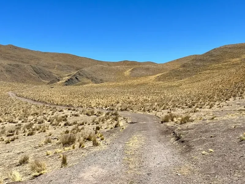
The true character of the hike changes once you break the treeline at approximately 1,000 metres. Here, the sheltered forest gives way to a stark, lunar landscape of slate-grey scree and alpine tundra. This is where the "Pliegue Tumbado" (the "tumbled" or "folded" fold) becomes visible—a massive geological structure where sedimentary layers have been buckled and overturned by the immense pressure of the rising Andes. The final push to the summit is often a battle against the elements, as the wind can reach speeds that make standing upright a challenge. However, the reward at the top is unparalleled: a direct line of sight across the Tunel Valley to the Southern Patagonian Ice Field, the turquoise expanse of Lake Viedma to the south, and the jagged, impossible silhouettes of Cerro Torre and Fitz Roy standing like sentinels to the north. It is a place where the scale of the Earth feels both intimate and infinite.
History and Cultural Context
The history of Loma del Pliegue Tumbado is inextricably linked to the founding of El Chaltén itself—a town that did not exist until 1985. The region was originally inhabited by the Aonikenk (Tehuelche) people, who named the dominant peak "Chaltén," meaning "smoking mountain," mistakenly believing the constant cloud cover around the summit was volcanic smoke. For the Aonikenk, these mountains were sacred, marking the western edge of their hunting grounds on the vast steppes.
In the late 19th century, European explorers and surveyors began to map the region. Francisco "Perito" Moreno, the famous Argentine geographer, explored the area in 1877 and renamed the central peak Mount Fitz Roy in honour of Robert FitzRoy, the captain of the HMS Beagle. The region remained a remote frontier for decades, primarily used for large-scale sheep ranching (estancias) by European immigrants. The trail you walk today often follows the old tracks used by gauchos to move livestock between summer and winter pastures.
The modern history of the trail is defined by a border dispute between Argentina and Chile. In 1985, the Argentine government established the village of El Chaltén to solidify its claim over the surrounding territory. Since then, the area has transformed from a lonely outpost into the "National Capital of Trekking." Loma del Pliegue Tumbado was one of the first routes formalised by the National Park Service (Administración de Parques Nacionales) to provide a panoramic alternative to the valley treks. The geological significance of the peak was recognised early on; the marine fossils found near the summit—remnants of an ancient seabed pushed skyward by the collision of tectonic plates—serve as a silent testament to the violent birth of the Andes. Today, the trail is maintained by a dedicated team of park rangers and volunteers who work to preserve the fragile alpine environment from the increasing pressure of global tourism.
Want more background? Read extended notes on history and cultural context → Learn more
Seasonal Highlights and Weather Reality
Patagonia is famous for experiencing "four seasons in one day," and Loma del Pliegue Tumbado is the ultimate stage for this meteorological theatre. Because the trail is highly exposed once it leaves the forest, weather awareness is the most critical component of a successful hike.
Summer (December to February): This is the peak trekking season. Days are long, with daylight lasting until 10:00 PM, allowing for a relaxed pace. Temperatures in the valley can reach a pleasant 20°C, but on the summit, they can plummet to near freezing with wind chill. This is also the windiest season; the "Roaring Forties" winds can blast across the ridge at over 100 kilometres per hour, sometimes making the final summit push dangerous.
Autumn (March to April): Many experienced hikers consider this the best time to visit. The Lenga forests turn a spectacular palette of fiery reds, oranges, and deep golds. The winds tend to be slightly less aggressive than in mid-summer, and the air is often exceptionally clear, providing the sharpest views of the granite spires. First snowfalls usually occur on the peaks in late April, adding a beautiful dusting of white to the landscape.
Spring (October to November): A season of rebirth and volatility. The wildflowers begin to bloom, and the birdlife is most active. However, the upper sections of the trail may still be covered in deep, soft snow, requiring gaiters and occasionally snowshoes or micro-spikes. The weather is highly unpredictable, with sudden rain or snow squalls common.
Winter (May to September): The trail is not officially closed, but it becomes an advanced winter mountaineering objective. The visitor centre is minimally staffed, and the trail is often buried under deep snow. Short daylight hours, extreme cold (down to -20°C), and the risk of avalanches on the steeper slopes mean this is only for those with significant winter experience and proper equipment. Most tourist infrastructure in El Chaltén shuts down during these months.
Recommended Itinerary
Loma del Pliegue Tumbado Day Hike Route
Early Morning: Departure and The Steppe
- Start Point: Ceferino Fonzo Visitor Centre (Guardaparque)
- Time: 08:00 – 09:30
- Distance: 0 – 3 km
- The trail begins with a gentle ascent through the open shrubland of the Patagonian steppe.
- Look for the "Sendero a Loma del Pliegue Tumbado" signpost near the park entrance.
- This section offers views back toward the town of El Chaltén and the winding Las Vueltas River.
- The path is well-marked and wide, allowing for a steady warm-up.
Morning: The Forest Sanctuary
- Time: 09:30 – 11:30
- Distance: 3 – 7 km
- Elevation: Entering the Lenga forest at approximately 600 m.
- The trail steepens as it enters the woodland. This is the most sheltered part of the hike.
- Keep an eye out for the Magellanic Woodpecker, the largest in South America, often heard drumming on old trees.
- The path crosses several small, seasonal streams (usually dry by late summer).
- A major trail junction appears around the 5 km mark; follow the signs for "Loma del Pliegue Tumbado" (the other path leads to Laguna Torre).
Midday: The Alpine Plateau and The Fold
- Time: 11:30 – 13:00
- Distance: 7 – 9 km
- Elevation: Breaking the treeline at 1,000 m.
- The forest thins out into stunted "krummholz" trees before disappearing entirely.
- The terrain shifts to rocky scree and low-lying alpine cushions.
- The wind usually increases significantly here. Ensure all layers are on before leaving the shelter of the trees.
- The trail levels out onto a broad, undulating plateau. To your right, the massive "folded" rock layers of the mountain become prominent.
Afternoon: The Summit and Descent
- Time: 13:00 – 17:00
- Distance: 9 – 20 km (including return)
- Elevation: Final push to 1,500 m summit.
- The final kilometre is the steepest, climbing a ridge of loose slate and rock.
- The summit provides a 360-degree view: Fitz Roy, Cerro Torre, Lake Viedma, and the Southern Ice Field.
- Spend time searching the rocks for marine fossils (belemnites and ammonites), but do not remove them.
- The descent follows the same route. Take care on the loose scree near the top to avoid slips.
- Return to El Chaltén for a well-earned meal and local craft beer.
Important Notes:
- There is no water available on the upper half of the trail; carry at least 2 litres per person.
- The summit is extremely exposed; if winds are too high, do not hesitate to turn back at the plateau.
- The trail is well-marked with yellow-topped stakes in the alpine section, but visibility can drop to zero in clouds.
- Total moving time is typically 6 hours, but allow 8 hours for photos and rest.
Planning and Bookings
Book Your Trip
Everything you need to plan your journey
Accommodation
Find places to stay near El Chalten
Flights
Search flights to El Chalten
Essential Preparation
Planning for Loma del Pliegue Tumbado requires more physical preparation than logistical booking. Unlike the famous multi-day treks in Torres del Paine (Chile), the trails around El Chaltén are free and do not require advanced reservations for day use. However, your base of operations will be the town of El Chaltén, which can become extremely crowded during the peak months of January and February. It is essential to book your town accommodation several months in advance for the summer season.
The logistical hub for the region is El Calafate, which hosts the nearest major airport (FTE). From El Calafate, you must take a bus to El Chaltén, a journey of approximately 3 hours across the vast Patagonian steppe. Several bus companies operate this route, with multiple departures daily. Once in El Chaltén, the trailhead for Loma del Pliegue Tumbado is within walking distance from any point in town, located at the southern end near the National Park Visitor Centre.
Fitness is a key consideration. While the trail is not technically difficult, the 1,100-metre vertical gain is significant for a single day. Hikers should be comfortable with sustained uphill walking for 3–4 hours. Training on hills or stair-climbers prior to arrival is highly recommended to ensure you enjoy the experience rather than just enduring it.
Trail Accommodation
This is a day hike requiring no overnight accommodation on the trail itself. Camping is strictly prohibited along the Loma del Pliegue Tumbado route to protect the fragile alpine ecosystem and the water sources for the town below.
Base Accommodation in El Chaltén:
- Hostels: Numerous budget-friendly options with shared dorms and communal kitchens. Ideal for solo travellers and those looking to meet other hikers.
- Hosterías and Hotels: Mid-range to luxury options providing private rooms, heating (essential!), and breakfast.
- Campsites: Several private campgrounds exist within the town limits, offering hot showers, wind protection, and cooking areas for a small fee.
- Apartments: Self-catering "cabañas" are popular for groups and families, allowing you to prepare your own trail lunches.
Facilities in Town:
- Supermarkets: Two main supermarkets provide all necessary supplies, though fresh produce can be limited depending on delivery schedules.
- Outdoor Stores: Several shops offer gear rental (poles, boots, jackets) and sales of technical equipment.
- Restaurants: El Chaltén has a vibrant food scene, specialising in Patagonian lamb, trout, and locally brewed craft beer.
- Connectivity: WiFi is notoriously slow and unreliable throughout the town. Do not rely on it for downloading maps or making urgent bookings.
Required Gear
- Hiking Boots: Sturdy, waterproof boots with good ankle support are essential for the rocky scree sections. Ensure they are well broken-in.
- Layered Clothing: The "three-layer system" is mandatory. A moisture-wicking base layer (merino wool is best), an insulating mid-layer (fleece or down), and a high-quality waterproof and windproof outer shell.
- Trekking Poles: Highly recommended for the 1,100 m descent to protect your knees and provide stability in high winds.
- Sun Protection: The ozone layer is thin in southern Patagonia. Bring high-SPF sunscreen, lip balm with SPF, and a wide-brimmed hat or buff.
- Eye Protection: Category 3 or 4 sunglasses are necessary to protect against high-altitude UV rays and flying dust/grit in the wind.
- Head Torch: Even for a day hike, always carry a head torch with spare batteries in case of an unexpected delay.
- Navigation: A physical map or a reliable offline GPS app (like Maps.me or Gaia GPS). Do not rely on cellular signal, as there is none on the trail.
What to Bring
- Water: At least 2 litres per person. While lower trails in Chaltén have many glacial streams, this trail stays on a ridge where water is scarce.
- High-Energy Food: Pack a substantial lunch plus high-calorie snacks (nuts, chocolate, energy bars). You will burn significant calories during the ascent.
- Personal First Aid Kit: Include blister plasters (Compeed), antiseptic wipes, painkillers, and any personal medications.
- Emergency Whistle: Often built into backpack chest straps, essential for signalling in low visibility.
- Trash Bag: To carry out all waste, including organic matter like orange peels or nut shells.
- Identification and Cash: Carry a copy of your passport and some Argentine Pesos for a post-hike drink or in case of emergency.
- Buff or Scarf: Essential for protecting your face from the abrasive wind and dust on the summit ridge.
Permits
One of the greatest appeals of trekking in the El Chaltén region is the lack of bureaucratic hurdles. Currently, there are no permits required and no entry fees for Los Glaciares National Park (Northern Sector). This is a rare privilege in the world of international trekking and is made possible by the Argentine National Park Service's commitment to public access.
Voluntary Registration: While not mandatory for the Loma del Pliegue Tumbado day hike, it is highly recommended to stop at the Ceferino Fonzo Visitor Centre (Guardaparque) at the trailhead. Here, you can:
- Check the latest weather forecast (updated twice daily).
- Receive updates on trail conditions (e.g., snow levels, fallen trees).
- Inform the rangers of your plans if you are hiking solo or in extreme weather.
- Obtain a free basic map of the trail network.
Regulations: Although no permit is needed, hikers must strictly adhere to National Park regulations:
- No fires allowed anywhere in the park. Only small gas stoves are permitted in designated camping areas (not applicable to this day hike).
- No domestic animals (dogs/cats) are allowed on the trails.
- Drones are strictly prohibited to protect the birdlife and the wilderness experience of other visitors.
- Stay on the marked trails to prevent erosion of the fragile volcanic soil.
Future Changes: There have been ongoing discussions about introducing an entry fee for the El Chaltén sector of the park, similar to the Perito Moreno Glacier sector near El Calafate. Always check the official Administración de Parques Nacionales website for the most current information before your trip.
Other Activities in the Area
El Chaltén is the trekking capital of Argentina for a reason. Once you have completed Loma del Pliegue Tumbado, there are numerous other world-class experiences within reach:
- Laguna de los Tres: The most famous hike in the area, leading to a turquoise glacial lake directly at the foot of Mount Fitz Roy. It is a challenging 24 km return trip.
- Laguna Torre: A flatter, 18 km return hike that leads to the base of the legendary Cerro Torre, one of the world's most difficult peaks to climb. The lake is often filled with icebergs.
- Huemul Circuit: For the truly adventurous, this 4-day trek involves river crossings by zip-line and offers views of the Viedma Glacier and the Southern Patagonian Ice Field.
- Ice Trekking on Viedma Glacier: Take a boat from Bahía Túnel and don crampons to explore the blue crevasses and ice caves of Argentina's largest glacier.
- Chorrillo del Salto: An easy, 3 km flat walk from town to a beautiful 20-metre waterfall, perfect for a recovery day.
- Rock Climbing: El Chaltén is a global hub for climbers. Local guides offer introductory courses on the granite boulders surrounding the town.
- Fly Fishing: The Las Vueltas River is renowned for its trout fishing, with several local operators offering guided day trips.
Safety and Conditions
The Patagonian Wind: The single greatest safety hazard on Loma del Pliegue Tumbado is the wind. Because the trail ascends a ridge and ends on an exposed summit, you are fully vulnerable to the westerly winds coming off the ice field. Gusts can exceed 100 km/h, which is enough to knock an adult off their feet. If you feel the wind is becoming dangerous, or if you see "lenticular" clouds (shaped like UFOs) forming over the peaks, it is a sign of extreme high-altitude winds. Do not attempt the summit in these conditions.
Hypothermia: Even in mid-summer, the combination of sweat from the ascent, high altitude, and piercing wind can lead to rapid cooling of the body. Always put on your windproof layer *before* you start feeling cold. If you get wet from rain or snow, your risk increases significantly. Carry spare dry layers in a waterproof dry bag inside your pack.
Navigation and Visibility: While the trail is well-defined, the upper plateau can become disorienting in "whiteout" conditions or heavy mist. The trail is marked with yellow stakes, but these can be hard to see in low visibility. Always have an offline GPS map and a compass. If you lose the trail, the safest course of action is to descend until you reach the treeline.
Water and Hydration: Unlike other trails in Chaltén, this route follows a ridge. There are no reliable water sources after the first 5 kilometres. Dehydration increases the risk of altitude sickness and fatigue. Carry a minimum of 2 litres of water per person.
Emergency Services: There is no cellular signal on the trail. In the event of a serious injury, someone must hike back to the Visitor Centre to alert the park rangers (Guardaparques). A mountain rescue team (Comisión de Auxilio) exists in El Chaltén, but rescues are difficult, time-consuming, and dependent on weather. Carrying a satellite communication device (like a Garmin inReach) is highly recommended for solo hikers.
Side Trips and Points of Interest
The Marine Fossils: Near the summit of Loma del Pliegue Tumbado, the ground is littered with dark, cylindrical stones. These are actually belemnites—the fossilised internal shells of extinct cephalopods that lived in the oceans during the Jurassic and Cretaceous periods. Finding these at 1,500 metres above sea level is a profound reminder of the geological forces that created the Andes. Look, photograph, but never remove them; they are protected by national law.
Mirador Laguna Torre: About halfway through the hike, there is a short, unmarked detour to a natural balcony that overlooks the Torre Valley. From here, you can see the entire length of the valley, the Fitz Roy River, and the distant Cerro Torre. It is a great spot for a first snack break before the final ascent.
The "Fold" (El Pliegue): As you reach the alpine plateau, look to the south (your left as you ascend). You will see a massive rock face where the sedimentary layers are not horizontal, but have been twisted into a vertical, almost circular "fold." This is one of the best-exposed examples of tectonic folding in the Southern Andes and gives the mountain its name.
Paso del Viento View: From the very summit, if you look past the Tunel Glacier to the west, you can see the gap in the mountains known as Paso del Viento (Wind Pass). This is the gateway to the Southern Patagonian Ice Field, the third-largest continental ice mass on Earth after Antarctica and Greenland.
Leave No Trace
The alpine environment of Loma del Pliegue Tumbado is extremely fragile. Plants at this altitude grow only a few millimetres per year and can be destroyed by a single misplaced footstep. As a visitor to Los Glaciares National Park, you have a responsibility to minimise your impact.
The Seven Principles in Patagonia:
- Plan Ahead and Prepare: Check the weather and ensure you have the right gear to avoid needing rescue.
- Travel on Durable Surfaces: Stay on the marked trail. Do not take shortcuts on the switchbacks, as this causes massive erosion during the spring snowmelt.
- Dispose of Waste Properly: Pack out everything. This includes "biodegradable" items like banana peels and apple cores, which do not decompose in the cold, dry Patagonian climate and can harm local wildlife.
- Leave What You Find: This is especially important for the marine fossils. Removing them is a crime and robs future hikers of the experience.
- Minimise Campfire Impacts: Fires are strictly prohibited. The dry Lenga forests are highly flammable; a single spark can destroy thousands of hectares.
- Respect Wildlife: Do not feed the birds or foxes. Feeding them habituates them to humans, which often leads to their death.
- Be Considerate of Others: Keep noise levels down. Let the sounds of nature prevail. Yield to uphill hikers on the narrow sections of the trail.