
Eiger Trail - The North Face's Shadow
The Eiger Trail is a spectacular day walk in the Bernese Alps of Switzerland, offering unparalleled close-up views of the legendary Eiger North Face. This iconic trail winds its way along the base of the formidable mountain, providing hikers with a unique perspective on its sheer rock walls, hanging glaciers, and the history of mountaineering triumphs and tragedies. It's a journey that immerses you in a dramatic alpine landscape, where the raw power of nature is on full display, and the echoes of daring ascents seem to linger in the crisp mountain air. While not a multi-day trek, the Eiger Trail demands respect for its alpine environment and offers a profound connection to one of the world's most famous climbing challenges.
- Distance: 6.0 km one-way
- Elevation Gain: 800 m
- Duration: 2-3 hours
- Difficulty: Moderate
- Best Time: June to October
- Closest City: Grindelwald
- Trailhead Access: Nearest airport: Zurich (ZRH). Take train to Grindelwald, then train to Eigergletscher. Or drive to Grindelwald (good roads), park at Grindelwald Grund, then train to Eigergletscher. Parking available at Grindelwald Grund (fee applies). No permits needed.
- Coordinates: 46.5778, 7.9742
Overview
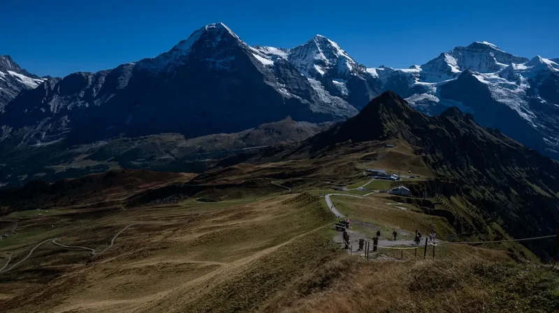
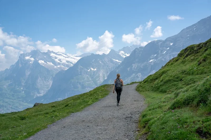
The Eiger Trail is a relatively short but intensely rewarding day walk that traces the formidable Eiger North Face. Starting from the Eigergletscher (Eiger Glacier) railway station, the path descends gradually towards Alpiglen, offering constant, breathtaking views of the imposing rock face that has captivated climbers for over a century. The trail is well-maintained and marked, making it accessible to most hikers with a reasonable level of fitness. Along the way, informative panels detail the history of ascents, famous climbers, and the geological significance of the region.
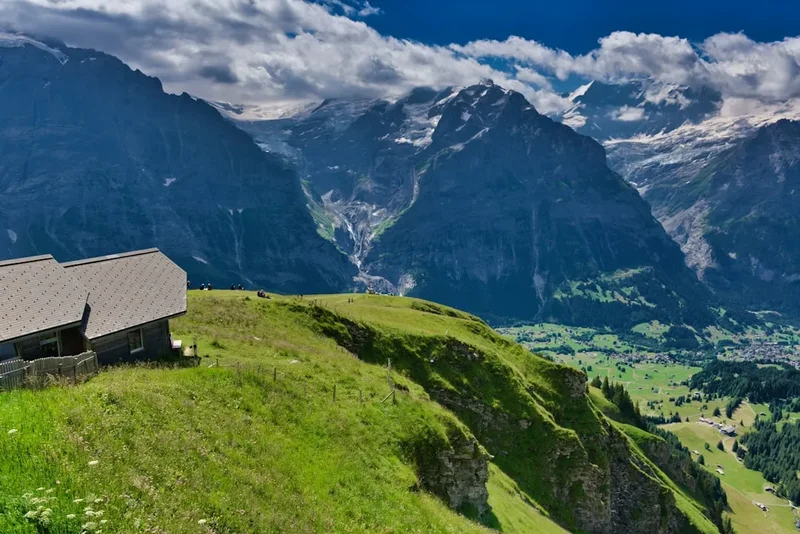
The landscape is a stark contrast of rugged rock, patches of alpine meadow, and the distant, shimmering glaciers. The sheer scale of the North Face is overwhelming; its verticality and the sheer amount of rock are difficult to comprehend from photographs alone. As you walk, you'll pass by scree slopes, small streams fed by snowmelt, and perhaps even spot hardy alpine flora clinging to the rocky terrain. The air is clean and crisp, carrying the scent of pine and damp earth. The soundscape is dominated by the wind, the distant rumble of rockfall, and the occasional chirping of alpine birds.
The trail's descent means that while the initial section offers expansive views, the latter part brings you closer to the base of the mountain, allowing for a more intimate appreciation of its textures and features. The journey concludes at Alpiglen, a charming alpine restaurant and a station on the Jungfrau Railway, providing a perfect spot to rest, refuel, and reflect on the incredible experience of walking in the shadow of the Eiger.
History and Cultural Context
The Eiger, meaning "Ogre" in German, has a history steeped in both daring adventure and tragic loss. Its North Face, a sheer wall of rock and ice rising over 1,800 metres, became the ultimate challenge for mountaineers in the early 20th century. The first successful ascent of the North Face was achieved in 1938 by an Austrian-German team led by Anderl Heckmair, a feat that cemented the Eiger's legendary status in the annals of climbing history.
However, the mountain also claimed many lives. The "Mordwand" (Murder Wall) earned its grim nickname through numerous failed attempts and fatal accidents. Climbers like Toni Kurz, whose dramatic rescue attempt in 1936 was widely publicised, became symbols of the mountain's unforgiving nature. The Eiger Trail itself was conceived and constructed to allow more people to experience the grandeur of the North Face without the extreme technical demands of climbing it. It was designed to be a pathway that honours the spirit of exploration while offering a safer, albeit still challenging, way to connect with this iconic peak.
The construction of the Jungfrau Railway, which began in 1898 and was completed in 1912, played a crucial role in making the Eiger accessible. This engineering marvel tunnels through the Eiger and Mönch mountains, with stations like Eigergletscher and Alpiglen providing convenient access points for hikers and tourists. The railway not only facilitated tourism but also supported the mountaineering efforts by allowing climbers to reach higher starting points and providing a means of escape or rescue.
Seasonal Highlights and Weather Reality
The Eiger Trail is typically accessible from June to October, coinciding with the warmer months when the snow has largely melted from the path. During this period, the alpine meadows are often carpeted with wildflowers, adding a splash of colour to the rugged landscape.
Summer (June to August): This is the peak season for hiking the Eiger Trail. The weather is generally warmer, and the days are long, providing ample time for the hike. Wildflowers are at their most vibrant, and the views are usually clear, offering excellent visibility of the North Face and surrounding peaks. However, summer can also bring afternoon thunderstorms, so starting early in the day is always advisable.
Autumn (September to October): As summer transitions into autumn, the crowds thin out, and the landscape takes on a golden hue. The air becomes crisper, and the light can be particularly beautiful for photography. While the weather is generally stable, early snowfalls can occur, especially at higher elevations, so checking conditions before setting out is crucial. Some of the alpine restaurants may begin to close towards the end of October.
Weather Considerations: The Eiger is notorious for its rapidly changing weather. Even in summer, conditions can shift dramatically. Fog can descend quickly, reducing visibility to mere metres, and temperatures can drop significantly, especially at higher altitudes. Wind can also be a factor, particularly along the exposed sections of the trail. It is essential to be prepared for all types of weather, including rain, wind, and even snow, regardless of the season.
Recommended Itinerary
Eiger Trail Day Hike Itinerary
Early Morning: Travel to Trailhead
- Depart from your accommodation in Grindelwald or a nearby town.
- Take the train from Grindelwald to Eigergletscher station. This scenic journey offers increasingly dramatic views as you ascend.
- Alternatively, drive to Grindelwald Grund, park your vehicle, and take the train from there to Eigergletscher.
Morning: Eigergletscher to Alpiglen
- Arrive at Eigergletscher station (2,320 m).
- Take a moment to absorb the initial views of the Eiger North Face and the surrounding glaciers.
- Begin the Eiger Trail descent towards Alpiglen.
- Distance: Approximately 6.0 km
- Elevation Change: Primarily descent (approx. 800 m loss)
- Estimated Time: 2-3 hours
- Key Waypoints:
- Eigergletscher Station (start)
- Informative panels detailing climbing history and geology
- Scree slopes and alpine meadows
- Views of the Eiger North Face, Mönch, and Jungfrau
- Alpiglen Station (end)
- The trail is well-marked and generally follows the contour of the mountain base.
- Be prepared for uneven terrain and some rocky sections.
Midday: Arrival at Alpiglen and Relaxation
- Arrive at Alpiglen (1,616 m).
- Enjoy the panoramic views from the restaurant terrace.
- Consider having lunch or a refreshing drink at the Alpiglen restaurant.
- Take photos and soak in the atmosphere of this charming alpine settlement.
Afternoon: Return Journey
- From Alpiglen, you can take the Jungfrau Railway back down to Grindelwald.
- Alternatively, for those seeking a longer hike, there are further trails descending from Alpiglen towards Grindelwald, though these are not part of the official Eiger Trail.
Important Notes:
- Wear sturdy hiking boots with good ankle support.
- Carry layers of clothing as mountain weather can change quickly.
- Bring plenty of water and snacks, although there is a restaurant at Alpiglen.
- Sun protection (hat, sunglasses, sunscreen) is essential due to the high altitude.
- Check the weather forecast and train schedules before you depart.
Planning and Bookings
Book Your Trip
Everything you need to plan your journey
Accommodation
Find places to stay near Grindelwald
Flights
Search flights to Grindelwald
Essential Preparation
The Eiger Trail is a day hike, meaning no overnight accommodation is required. However, proper planning is still essential to ensure a safe and enjoyable experience. The closest major town and logistical hub is Grindelwald, which offers a wide range of accommodation options, from budget hostels to luxury hotels. Grindelwald is easily accessible by train from major Swiss cities like Zurich and Bern. If driving, there are parking facilities available in Grindelwald, though fees may apply.
Access to the trailhead at Eigergletscher is primarily via the Jungfrau Railway. It is advisable to purchase your train tickets in advance, especially during peak season, to avoid queues. Check the operating times of the Jungfrau Railway and the Eiger Trail itself, as they can be subject to seasonal changes or weather-related closures.
Trail Accommodation
This is a day hike requiring no overnight accommodation.
Required Gear
- Hiking Boots: Sturdy, waterproof hiking boots with good ankle support are crucial for navigating the uneven terrain.
- Waterproof Jacket: A breathable, waterproof jacket is essential, as mountain weather can change rapidly, bringing rain or wind.
- Warm Layers: Even in summer, temperatures can be cool at altitude. Bring a fleece or insulating jacket, and consider a hat and gloves.
- Backpack: A comfortable daypack (20-30 litres) to carry essentials like water, snacks, extra clothing, and a first-aid kit.
- Navigation: While the Eiger Trail is well-marked, a map of the area and a compass or GPS device are always recommended for safety. A smartphone with offline maps can also be useful.
- Safety Gear: A basic first-aid kit, including blister treatment, pain relievers, and any personal medications. A head torch is advisable in case of unexpected delays.
What to Bring
- Food and Water: Carry at least 1.5-2 litres of water per person. While there is a restaurant at Alpiglen, it's wise to have your own supplies. Pack high-energy snacks such as trail mix, energy bars, and fruit.
- Sun Protection: High SPF sunscreen, sunglasses, and a wide-brimmed hat are essential due to the strong alpine sun at altitude.
- Personal Items: Toiletries, hand sanitiser, and any personal items you may need.
- Camera: To capture the stunning scenery.
- Cash: For purchases at the Alpiglen restaurant or for train tickets if not purchased in advance.
Permits
No specific permits are required to hike the Eiger Trail. Access to the trail and the surrounding area is generally free. However, you will need to purchase tickets for the Jungfrau Railway to reach the trailhead at Eigergletscher and to return from Alpiglen.
Jungfrau Railway Tickets:
- Tickets can be purchased at any Jungfrau Railways station, including Grindelwald, or online in advance.
- Prices vary depending on the route and any special offers or passes you might have (e.g., Swiss Travel Pass, Half Fare Card).
- It is advisable to check the official Jungfrau Railways website for the most up-to-date pricing and booking information.
Considerations:
- During peak season (summer months), it is recommended to book your train tickets in advance to save time and ensure availability, especially for the journey to Eigergletscher.
- If you plan to visit multiple Jungfrau region attractions, consider purchasing a regional pass, which may offer better value.
Other Activities in the Area
The Jungfrau region surrounding the Eiger Trail offers a wealth of activities for visitors:
- Jungfraujoch – Top of Europe: Take the train further up to the highest railway station in Europe for spectacular views of the Aletsch Glacier and the surrounding peaks. This is a major attraction with an ice palace, observation deck, and snow fun park.
- Grindelwald-First: Accessible by cable car from Grindelwald, this area offers the First Cliff Walk by Tissot, a thrilling suspension bridge experience, and activities like the First Flyer (zip line) and First Glider.
- Hiking: Numerous other hiking trails crisscross the region, catering to all levels of fitness and offering diverse scenery, from gentle valley walks to challenging alpine routes.
- Mountain Biking: Several trails are suitable for mountain biking, with bike rental available in Grindelwald.
- Paragliding and Hang Gliding: Grindelwald is a popular spot for tandem paragliding flights, offering a bird's-eye view of the Eiger and the surrounding valleys.
- Adventure Activities: In Grindelwald, you can find activities like canyoning, via ferrata, and summer toboggan runs.
- Exploring Grindelwald Village: Enjoy the charming alpine village atmosphere, browse local shops, and sample Swiss cuisine in its many restaurants and cafes.
Safety and Conditions
Weather Awareness: The most critical safety aspect on the Eiger Trail is being prepared for rapid weather changes. Always check the mountain forecast before you set out. MetService or local Swiss weather services provide reliable forecasts for the region. Be prepared for sun, wind, rain, and even snow, regardless of the season.
Trail Conditions: The Eiger Trail is generally well-maintained and marked. However, sections can be rocky and uneven. In early season (June) or after heavy rain, there may be muddy patches or slippery rocks. Always wear appropriate footwear.
Altitude: The trail starts at Eigergletscher (2,320 m) and descends. While the altitude is not extreme, some individuals may experience mild altitude sickness. Take your time, stay hydrated, and be aware of symptoms like headache, nausea, or dizziness.
Rockfall: While the Eiger Trail is designed to be safe, the Eiger North Face is an active rock face. Small rockfalls can occur, especially after heavy rain or during freeze-thaw cycles. It is advisable to stay on the marked path and avoid lingering in areas directly beneath steep rock walls.
Emergency Procedures:
- In case of an emergency, call the Swiss emergency number: 144 (medical) or 112 (general emergency).
- Inform someone of your hiking plans, including your intended route and expected return time.
- Carry a fully charged mobile phone, although reception can be intermittent in mountainous areas.
- Consider carrying a whistle for signalling in emergencies.
Personal Fitness: The Eiger Trail involves a significant descent, which can be hard on the knees. Ensure you have a reasonable level of fitness and are comfortable walking downhill for an extended period.
Side Trips and Points of Interest
Eiger North Face Information Panels: Scattered along the trail are numerous informative panels that detail the history of the Eiger North Face, its most famous ascents, and the climbers who have attempted it. These panels provide fascinating insights into the challenges and triumphs associated with this legendary mountain.
Geological Features: Observe the unique geological formations, including the scree slopes, glacial moraines, and the sheer rock faces of the Eiger. The trail offers a close-up look at the forces that have shaped this dramatic alpine landscape.
Alpine Flora and Fauna: Keep an eye out for the hardy alpine flowers that bloom in the meadows during the summer months. You might also spot marmots or various alpine bird species.
Panoramic Views: Beyond the Eiger itself, the trail offers stunning panoramic views of the surrounding Bernese Alps, including the Mönch and Jungfrau mountains, as well as the Grindelwald valley below. These vistas provide ample opportunities for photography and quiet contemplation.
Alpiglen Restaurant: While not a natural point of interest, the Alpiglen restaurant at the end of the trail is a significant landmark. It offers a place to rest, enjoy refreshments, and soak in the atmosphere of a traditional Swiss alpine establishment, all with a magnificent backdrop.
Leave No Trace
The Eiger Trail, like all natural environments, deserves our utmost respect. Adhering to Leave No Trace principles ensures that this beautiful alpine landscape remains pristine for future generations to enjoy.
Your responsibility as a hiker:
- Stay on the Trail: Stick to the marked path to prevent erosion and protect fragile alpine vegetation. Straying off-trail can damage delicate ecosystems that take years to recover.
- Pack It In, Pack It Out: Carry out all your rubbish, including food scraps, wrappers, and any other waste. Do not bury or burn litter.
- Respect Wildlife: Observe animals from a distance and never feed them. Feeding wildlife can disrupt their natural behaviours and diets, and can make them dependent on humans.
- Minimize Campfire Impacts: Campfires are generally not permitted on the Eiger Trail, as it is a day hike. If camping in designated areas elsewhere in the region, use established fire rings and ensure fires are completely extinguished.
- Travel and Camp on Durable Surfaces: For day hikes, this means staying on the trail. If you were to camp, choose established campsites or durable surfaces like rock or gravel.
- Leave What You Find: Do not take rocks, plants, or any other natural objects from the environment.
- Be Considerate of Other Visitors: Keep noise levels down, yield to other hikers, and maintain a respectful attitude towards fellow visitors.
By following these principles, you contribute to the preservation of the Eiger Trail's natural beauty and ensure a positive experience for everyone.