
East MacDonnell Ranges Trail
The East MacDonnell Ranges Trail is a spectacular multi-day bushwalking experience in Australia's Northern Territory, offering a profound immersion into the ancient landscapes and vibrant colours of the Red Centre. Stretching approximately 220 kilometres, this trail winds through a dramatic geological wonderland of rugged gorges, towering rock formations, ephemeral waterholes, and vast desert plains. It connects a series of iconic natural landmarks, each with its own unique character and ecological significance, providing a challenging yet immensely rewarding journey for experienced hikers.
This trail is not for the faint-hearted. It demands a high level of fitness, self-sufficiency, and meticulous planning due to its remote location, challenging terrain, and the harsh desert environment. However, for those prepared to embrace the adventure, the East MacDonnell Ranges Trail offers an unparalleled opportunity to witness the raw beauty and profound stillness of the Australian Outback, far from the usual tourist trails. It’s a journey that tests physical endurance while simultaneously nourishing the soul with its breathtaking vistas and deep sense of isolation.
- Distance: 220.0 km one-way
- Duration: 9–14 days
- Season: April to September (cooler months)
- Difficulty: Moderate to Hard (due to remoteness and self-sufficiency requirements)
- Closest City: Alice Springs
- Trailhead Access: Fly to Alice Springs Airport (ASP). Drive east via Ross Highway. Trailhead locations vary; Emily Gap is approximately 10 km from Alice Springs. Car rental recommended. 2WD accessible to Emily Gap. Check road conditions before accessing more remote trailheads. Parking at trailheads. No permits required for hiking, but check park regulations.
- Highest point: Varies, but significant elevation changes occur throughout the route.
- Daily walkers: No daily limits, but self-sufficiency is paramount.
- Direction: Generally west to east, but can be traversed in either direction depending on access and logistics.
Overview
The East MacDonnell Ranges Trail is a significant undertaking, traversing a landscape that has been shaped over millions of years by geological forces and the relentless power of the elements. Unlike more manicured national park tracks, this route often follows faint animal trails, dry creek beds, and open country, requiring strong navigation skills and a keen sense of direction. The trail is a true bushwalking expedition, demanding that participants carry all their food, water, and camping equipment for the duration of the trek.
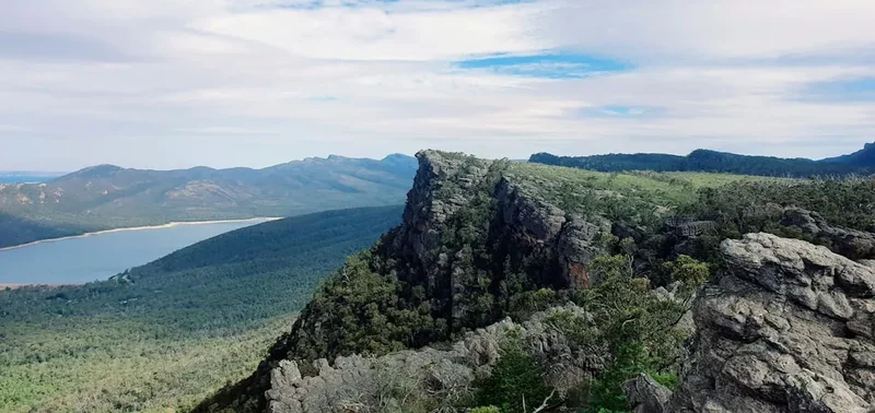
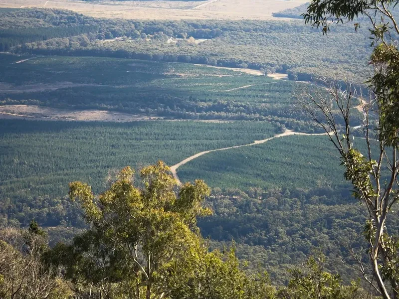
The journey begins near Alice Springs, quickly plunging into the heart of the ranges. Early sections might take you through the dramatic gorges of Emily Gap and Jessie Gap, showcasing the vibrant red rock formations that are characteristic of the region. As the trail progresses eastward, it opens up to vast plains dotted with spinifex and acacia, interspersed with more rugged outcrops and hidden waterholes. Key landmarks include the imposing granite domes of Trephina Gorge, the narrow slot canyons of John Hayes Rockhole, and the expansive views from viewpoints like the Panorama at Arltunga Historical Reserve. The trail often follows the dry riverbeds of ephemeral creeks, which can transform into raging torrents after rare but significant rainfall events, adding an element of dynamic challenge and requiring constant vigilance regarding weather conditions.
The flora and fauna of the East MacDonnells are adapted to the arid environment. While seemingly sparse, the desert teems with life. Keep an eye out for kangaroos, wallabies, various reptile species, and a diverse array of birdlife, including the iconic wedge-tailed eagle soaring overhead. The plant life, though often hardy and spiky, displays remarkable resilience and beauty, with wildflowers blooming spectacularly after good rains. The trail's remoteness is a significant drawcard, offering a profound sense of solitude and a chance to disconnect from the modern world. Nights are spent under a canopy of stars so brilliant they seem to hang within reach, a truly unforgettable experience.
This trail is best suited for experienced bushwalkers who are comfortable with navigation, self-sufficiency, and the challenges of desert environments. It is a journey that rewards preparation, resilience, and a deep appreciation for the stark beauty of the Australian Outback.
History and Cultural Context
The East MacDonnell Ranges are an ancient landscape, holding deep cultural significance for the Arrernte people, the Traditional Owners of this land. For tens of thousands of years, the Arrernte have lived in and cared for this country, their lives intrinsically linked to its cycles of rain, sun, and seasons. The ranges are rich with Dreaming stories, sacred sites, and ancestral pathways that crisscross the land, telling tales of creation, law, and the spiritual forces that shaped the world. Many of the gorges, waterholes, and rock formations are imbued with spiritual power and are places of ceremony and learning. The Arrernte people possess an intimate knowledge of the land, its resources, and its ecological rhythms, a knowledge passed down through generations.
European exploration of the MacDonnell Ranges began in the mid-19th century. In 1860, explorer John McDouall Stuart led an expedition that sighted the ranges, naming them after Sir Richard MacDonnell, the Governor of South Australia. Stuart's expeditions were crucial in charting routes across the continent, and his findings paved the way for later settlement and resource exploration. The discovery of gold in the late 19th century led to a brief but intense gold rush in the region, most notably at the Arltunga goldfields. This period saw the establishment of a small, rugged mining town, the remnants of which can still be explored today, offering a glimpse into the harsh realities of pioneering life in the Outback.
The East MacDonnell Ranges were also a significant area for pastoralism, with cattle stations established in the early 20th century. However, the arid climate and challenging terrain meant that large-scale agricultural development was limited. Today, much of the area is protected within national parks and Aboriginal freehold land, with a focus on conservation and cultural heritage preservation. The East MacDonnell Ranges Trail allows walkers to connect with both the ancient cultural heritage of the Arrernte people and the more recent history of exploration and resource extraction, all set against a backdrop of breathtaking natural beauty.
Seasonal Highlights and Weather Reality
The East MacDonnell Ranges experience a classic desert climate, characterised by extreme temperatures and low rainfall. The best time to undertake the East MacDonnell Ranges Trail is during the cooler months, from April to September. This period, known locally as the "Dry Season" or "Winter," offers the most favourable conditions for bushwalking.
April to May (Autumn): Temperatures begin to moderate, with daytime highs typically ranging from 25°C to 30°C. Nights become cooler, often dropping to around 10°C to 15°C, making for comfortable camping. The landscape is often still recovering from any summer rains, with a chance of lingering greenness and wildflowers.
June to August (Winter): This is the prime season for hiking. Daytime temperatures are pleasant, usually between 20°C and 25°C, while nights can be quite cold, frequently dropping to 5°C or below, sometimes even experiencing light frosts. It is essential to be prepared for these cold nights with appropriate sleeping gear. Rainfall is minimal during these months.
September (Spring): Temperatures begin to rise again, with daytime highs reaching 30°C or more by the end of the month. Nights remain cool initially but gradually warm up. This is also a time when wildflowers can be particularly spectacular if good rains have occurred in the preceding months. However, the increasing heat can make hiking more challenging.
October to March (Summer): This period is generally considered too hot for extended bushwalking. Daytime temperatures frequently exceed 40°C, and can reach into the high 40s. The risk of heatstroke, dehydration, and sun exposure is extremely high. While rare, summer thunderstorms can bring flash floods, making gorges and dry creek beds dangerous. This season is best avoided for multi-day treks.
Weather Considerations: Even during the cooler months, desert weather can be unpredictable. Strong winds can occur, and dust storms are possible. Always check the weather forecast before and during your trek, and be prepared for variations in temperature. The remoteness of the trail means that self-reliance is key; you must be equipped to handle a range of conditions.
Recommended Itinerary
East MacDonnell Ranges Trail: A Sample 10-Day Itinerary
This itinerary is a suggestion and can be adapted based on fitness, pace, and logistical arrangements. It assumes a west-to-east traverse, starting near Alice Springs.
Day 1: Emily Gap to Jessie Gap
- Distance: 12 km
- Elevation gain: Minimal, undulating terrain
- Time: 3–4 hours
- Start at Emily Gap trailhead (approx. 10 km east of Alice Springs via Ross Highway)
- Walk through the scenic Emily Gap, known for its Aboriginal rock art
- Continue through open country and rocky outcrops towards Jessie Gap
- Establish camp at a suitable location near Jessie Gap
- Initial day to acclimatise to the desert environment and pack weight
Day 2: Jessie Gap to Corroboree Rock
- Distance: 15 km
- Elevation gain: Gentle undulations
- Time: 4–5 hours
- Follow the trail eastward, passing through varied desert landscapes
- Navigate around rocky sections and dry creek beds
- Arrive at Corroboree Rock, a significant cultural site
- Set up camp in the vicinity of Corroboree Rock
Day 3: Corroboree Rock to Trephina Gorge Area
- Distance: 18 km
- Elevation gain: Moderate, with some rocky ascents
- Time: 5–6 hours
- Continue east, with the terrain becoming more rugged
- The landscape begins to show the dramatic formations leading towards Trephina Gorge
- Aim to camp in a suitable location within or near the Trephina Gorge National Park boundary
Day 4: Exploring Trephina Gorge and John Hayes Rockhole
- Distance: 8 km (exploration)
- Elevation gain: Significant within gorges
- Time: Full day
- This day is dedicated to exploring the spectacular Trephina Gorge and John Hayes Rockhole
- Hike into the narrow slot canyons of Trephina Gorge, a truly immersive experience
- Visit John Hayes Rockhole, a permanent waterhole surrounded by towering cliffs
- Camp again in the Trephina Gorge area, allowing ample time for exploration
Day 5: Trephina Gorge to N'Dhala Gorge Area
- Distance: 20 km
- Elevation gain: Undulating, with some rocky sections
- Time: 6–7 hours
- Depart the Trephina Gorge area, heading further east
- The trail may involve traversing open plains and rocky ridges
- Aim to reach a suitable camping spot in the vicinity of N'Dhala Gorge
Day 6: Exploring N'Dhala Gorge and surrounds
- Distance: 10 km (exploration)
- Elevation gain: Moderate within the gorge
- Time: Half to full day
- Explore the impressive N'Dhala Gorge, known for its unique rock formations and Aboriginal art sites
- This gorge offers a different character to Trephina, with its own distinct beauty
- Camp in the N'Dhala Gorge area
Day 7: N'Dhala Gorge to Arltunga Historical Reserve Area
- Distance: 25 km
- Elevation gain: Varied, can be challenging
- Time: 7–8 hours
- A longer day of trekking, covering significant distance across varied terrain
- The route may involve navigating through more remote sections of the ranges
- Aim to camp in a location that allows for easy access to the Arltunga Historical Reserve the following day
Day 8: Arltunga Historical Reserve Exploration
- Distance: 10 km (exploration)
- Elevation gain: Moderate
- Time: Half to full day
- Explore the historic Arltunga goldfields
- Visit the old mine shafts, stone ruins, and the visitor centre to learn about the area's gold rush past
- Camp near the Arltunga Historical Reserve
Day 9: Arltunga to a designated exit point (e.g., near White Tank)
- Distance: 22 km
- Elevation gain: Undulating
- Time: 6–7 hours
- Continue eastward, the landscape may become more open as you move away from the core ranges
- Navigate towards a pre-arranged pick-up point or a point accessible by vehicle
- Establish final camp
Day 10: Exit and Transport
- Distance: 5 km (final approach to pick-up)
- Time: 1–2 hours
- Short walk to the designated exit point
- Meet pre-arranged transport (e.g., 4WD vehicle) for return to Alice Springs
- Allow for a full day for transport and recovery
Important Notes:
- This itinerary is a guideline; actual distances and times may vary significantly based on terrain, weather, and individual pace.
- Water sources are scarce and unreliable. All water must be carried or treated from known reliable sources (which are few and far between).
- Navigation is critical. A good map, compass, and GPS device are essential.
- Communication is limited. A satellite phone or personal locator beacon (PLB) is highly recommended.
- Logistics for transport to the start and from the end point must be meticulously arranged in advance.
- Be prepared for extreme heat, even in the cooler months, and carry ample sun protection.
Planning and Bookings
Book Your Trip
Everything you need to plan your journey
Accommodation
Find places to stay near Alice Springs
Flights
Search flights to Alice Springs
Essential Preparation
The East MacDonnell Ranges Trail is a serious undertaking that requires meticulous planning and a high degree of self-sufficiency. Unlike well-established national park tracks, this route often involves navigating through remote and rugged terrain with limited facilities and very scarce water sources. Thorough preparation is not just recommended; it is critical for safety and success.
Fitness: A high level of cardiovascular fitness and muscular endurance is essential. You will be carrying a heavy pack (20-25 kg or more) over long distances, often on uneven and challenging terrain, including steep ascents and descents, rocky scrambles, and soft sand. Regular training with a weighted pack is highly advisable. Practice hiking for extended periods, including multi-day trips, to build stamina and acclimatise your body to the demands of the trek.
Navigation: This is paramount. The trail is not always clearly marked and often follows dry creek beds, animal tracks, or open country. You must be proficient in map reading, compass use, and GPS navigation. Carry detailed topographic maps of the area, a reliable GPS device with spare batteries, and a compass. Familiarise yourself with the route and potential landmarks before you depart.
Logistics: Arranging transport to the trailhead and from the exit point is a major logistical challenge. Given the remote nature of the trailheads, a 4WD vehicle is often necessary, especially for accessing more distant starting and ending points. Consider hiring a 4WD vehicle or arranging a shuttle service with a local tour operator. Ensure your transport plan is robust and includes contingency options. Inform someone of your detailed itinerary and expected return date.
Base Town: Alice Springs is the closest major town and the primary logistical hub for this trek. It offers all necessary services, including supermarkets for food supplies, outdoor gear shops for equipment and repairs, fuel stations, and accommodation. It is essential to stock up on all supplies in Alice Springs before heading out to the trail. Allow at least a day or two in Alice Springs before your trek to finalise preparations and acclimatise to the region.
Trail Accommodation
This is a bushwalking expedition requiring self-sufficient camping. There are no established huts, lodges, or designated campsites along the East MacDonnell Ranges Trail. Walkers must carry all their own camping equipment, including tents, sleeping bags, and cooking gear.
Camping: You will be camping in the wilderness. This means finding suitable, safe, and environmentally responsible locations to pitch your tent each night. Generally, camping is permitted in most areas of the national parks and surrounding Crown land, provided you are away from water sources and sensitive ecological areas. Always follow Leave No Trace principles (see section 11). Some areas, like Trephina Gorge and Arltunga Historical Reserve, may have designated camping areas or facilities such as pit toilets, but these are exceptions rather than the rule.
Facilities: Beyond the occasional pit toilet at designated areas (like some national park campgrounds), there are no facilities along the trail. You must be entirely self-sufficient for shelter, sanitation, and all other needs.
Seasonal Availability: Camping is possible year-round, but highly discouraged during the summer months (October to March) due to extreme heat and the risk of flash floods. The cooler months (April to September) are ideal for camping.
Costs: There are generally no camping fees for dispersed wilderness camping. However, entry fees may apply to some national parks, and any organised shuttle or 4WD transport will incur costs.
Required Gear
- Backpack: A robust, comfortable pack of 70-90 litre capacity, with a good hip belt and adjustable harness. Ensure it has a rain cover.
- Tent: A lightweight, durable, and freestanding tent suitable for desert conditions. Consider one with good ventilation and protection against wind and dust.
- Sleeping Bag: A 3-season or 4-season sleeping bag rated to at least -5°C to -10°C, as desert nights can be very cold, especially from June to August.
- Sleeping Mat: An insulated sleeping mat for comfort and warmth.
- Boots: Sturdy, broken-in hiking boots with good ankle support and aggressive tread. Waterproofing is beneficial, though less critical in the arid climate than in wet regions.
- Clothing:
- Moisture-wicking base layers (synthetic or merino wool)
- Insulating mid-layers (fleece or down jacket)
- Durable hiking trousers (quick-drying)
- Long-sleeved shirts (for sun protection)
- Warm hat (beanie) and gloves for cold nights
- Wide-brimmed hat for sun protection
- Camp shoes or sandals
- Navigation:
- Detailed topographic maps of the East MacDonnell Ranges
- Compass
- GPS device with spare batteries and charging capability (e.g., power bank)
- Personal Locator Beacon (PLB) or satellite phone (highly recommended for remote areas)
- Safety Gear:
- Comprehensive first-aid kit, including blister treatment, pain relief, antiseptic wipes, bandages, and any personal medications.
- Emergency shelter (e.g., lightweight bivvy bag or space blanket)
- Whistle
- Multi-tool or knife
- Duct tape and repair kit for gear
- Head Torch: With spare batteries.
What to Bring
- Food: All food for the duration of the trek (9-14 days). This must be lightweight, non-perishable, and calorie-dense. Plan meals carefully, including breakfast, lunch, dinner, and plenty of snacks. Dehydrated meals are a good option.
- Water: This is the most critical item. Carry a minimum of 5-7 litres of water per person per day, depending on the season and expected temperatures. Water sources are extremely scarce and unreliable. Plan your water resupply points meticulously and carry a reliable water filter or purification tablets as a backup. A combination of water bladders and bottles is recommended.
- Cooking Gear:
- Lightweight camping stove (e.g., gas or liquid fuel)
- Fuel for the stove
- Cooking pot and lid
- Utensils (spork or spoon/fork)
- Mug
- Biodegradable soap and small sponge for cleaning
- Toiletries:
- Toothbrush and toothpaste
- Biodegradable toilet paper
- Small trowel for burying human waste (if not using pit toilets)
- Hand sanitiser
- Sunscreen (SPF 50+)
- Insect repellent (for sandflies and mosquitoes, though less prevalent in the dry season)
- Lip balm with SPF
- Miscellaneous:
- Sunglasses
- Camera and spare batteries/memory cards
- Book or journal for downtime
- Trekking poles (highly recommended for stability and reducing strain)
- Small daypack for side trips (optional)
- Rubbish bags (to pack out all waste)
- Cash for any potential services or park entry fees
Permits
For the most part, hiking the East MacDonnell Ranges Trail does not require specific permits for the act of walking itself, provided you are adhering to the regulations of the national parks and surrounding lands you traverse. However, it is crucial to be aware of and comply with all park rules and regulations.
National Park Entry: Entry into some national parks within the East MacDonnell Ranges, such as Trephina Gorge and Arltunga Historical Reserve, may incur an entry fee. These fees are typically paid at self-registration stations or can be purchased in advance. Check the Parks and Wildlife Northern Territory website for the most current information on park fees and any specific entry requirements.
Aboriginal Land: Significant portions of the East MacDonnell Ranges are Aboriginal freehold land. Access to these areas may be restricted or require specific permission from the Traditional Owners or relevant land councils. It is imperative to research and understand the land tenure of the areas you plan to traverse. Respecting cultural protocols and seeking permission where necessary is paramount. Some areas may be closed for cultural reasons or during specific times of the year.
Camping: While dispersed wilderness camping is generally permitted in many areas, some national parks may have designated camping areas with associated fees or regulations. Always check the specific rules for the parks you intend to camp in. For example, Arltunga Historical Reserve may have designated camping facilities.
Fire Restrictions: Be aware of and strictly adhere to any fire restrictions in place. Campfires may be prohibited entirely or restricted to designated fire pits, especially during the dry season when bushfire risk is high. Always carry a fuel stove for cooking.
Research is Key: Before embarking on your trek, thoroughly research the land management status of your intended route. Consult the Parks and Wildlife Northern Territory website, and if your route crosses Aboriginal land, contact the relevant Central Land Council or Traditional Owner group for information on access and any required permissions. Ignorance of land access rules can lead to significant penalties and disrespect for cultural heritage.
Other Activities in the Area
The East MacDonnell Ranges offer a wealth of experiences beyond the multi-day trek, making it a fantastic destination for exploration:
- Day Hikes and Gorge Exploration: Many of the iconic gorges, such as Trephina Gorge, N'Dhala Gorge, and John Hayes Rockhole, are accessible via shorter day walks. These offer a taste of the dramatic scenery without the commitment of a multi-day trek.
- Arltunga Historical Reserve: Immerse yourself in the region's gold rush past. Explore the ruins of the old mining town, visit the visitor centre, and learn about the challenging lives of the prospectors.
- Scenic Drives: The Ross Highway and other unsealed tracks (requiring 4WD) offer spectacular scenic drives through the ranges, allowing you to access trailheads and viewpoints with relative ease.
- Stargazing: The remote location and clear desert skies provide unparalleled opportunities for stargazing. Away from light pollution, the Milky Way is a breathtaking spectacle.
- Cultural Tours: Engage with the rich cultural heritage of the Arrernte people by participating in guided tours that offer insights into Dreamtime stories, traditional practices, and sacred sites.
- Rock Art Sites: Many gorges and rock shelters contain ancient Aboriginal rock art, offering a glimpse into the spiritual and artistic traditions of the region's first inhabitants. Access to some sites may be restricted or require guided tours.
- Birdwatching: The varied habitats, including ephemeral waterholes and rocky outcrops, attract a diverse range of bird species.
Safety and Conditions
Extreme Heat and Dehydration: This is the single greatest risk. Temperatures can soar, and dehydration can occur rapidly. Always carry more water than you think you will need, and drink regularly, even if you don't feel thirsty. Electrolyte supplements are highly recommended. Plan your hiking for the cooler parts of the day (early morning and late afternoon) and rest during the hottest hours.
Flash Flooding: While the region is arid, heavy rainfall can cause sudden and dangerous flash floods in gorges and dry creek beds. Never camp or shelter in a gorge or creek bed during or immediately after rain. Monitor weather forecasts closely and be prepared to alter your route or wait for conditions to improve.
Navigation: The trail is often unmarked and can be difficult to follow. Proficiency in map reading, compass use, and GPS navigation is essential. Carry detailed maps, a compass, and a GPS device, and know how to use them. Inform someone of your itinerary and expected return date.
Remoteness and Communication: Mobile phone reception is virtually non-existent in most of the East MacDonnell Ranges. A Personal Locator Beacon (PLB) or satellite phone is strongly recommended for emergencies. Ensure your PLB is registered and you know how to operate it.
Wildlife: While large dangerous animals are not a significant concern, be aware of snakes (venomous species are present), spiders, and scorpions. Store food securely to avoid attracting dingoes or other scavengers. Respect all wildlife and maintain a safe distance.
Bushfires: The risk of bushfires is high, especially during warmer months. Be aware of fire bans and conditions. If you see a fire, report it immediately using your PLB or satellite phone if possible. If caught in a fire, seek shelter in a rocky area or a pre-identified safe zone.
Gear Failure: Carry a comprehensive repair kit for your gear, including duct tape, cordage, and patches. A multi-tool is invaluable.
First Aid: Carry a well-stocked first-aid kit and know how to use it. Consider taking a wilderness first-aid course.
Water Sources: Water sources are extremely scarce and unreliable. Do not rely on finding water along the route unless you have confirmed recent reports of its availability. Carry all the water you need for the entire trek or have a meticulously planned resupply strategy.
Side Trips and Points of Interest
Trephina Gorge: A highlight of the East MacDonnells, Trephina Gorge is a magnificent example of the region's dramatic geology. The narrow slot canyons offer a challenging and rewarding hiking experience, with towering red rock walls that create a sense of awe. Exploring the gorge floor and its hidden recesses is a must-do. The surrounding area also offers excellent viewpoints and shorter walks.
John Hayes Rockhole: Located near Trephina Gorge, this is a permanent waterhole that provides a vital oasis in the arid landscape. Surrounded by sheer cliffs, it's a beautiful spot for a break and a chance to observe the local flora and fauna that depend on the water. The rock formations here are particularly striking.
N'Dhala Gorge: Another significant gorge system, N'Dhala Gorge is known for its unique rock formations and its importance as a site of Aboriginal rock art. Exploring this gorge offers a deeper connection to the cultural heritage of the region, with ancient engravings and paintings adorning the rock faces.
Arltunga Historical Reserve: Step back in time at the Arltunga goldfields. This reserve preserves the remnants of a bustling gold rush town from the late 19th and early 20th centuries. You can explore the stone ruins of buildings, old mine shafts, and learn about the harsh realities of life for the prospectors who sought their fortune here. It's a fascinating historical detour.
Panorama at Arltunga: A viewpoint offering expansive vistas over the rugged landscape surrounding Arltunga. It provides a great opportunity to appreciate the scale and grandeur of the East MacDonnell Ranges from a higher vantage point.
White Tank: Often used as an exit point or a staging area, White Tank is a significant waterhole and a landmark in the eastern part of the ranges. It can serve as a reference point for navigation and a potential, though unreliable, water source.
Scenic Lookouts along Ross Highway: Numerous informal lookouts and viewpoints are scattered along the Ross Highway, offering stunning photographic opportunities of the ranges, particularly at sunrise and sunset when the colours of the rock formations are at their most vibrant.
Leave No Trace
The East MacDonnell Ranges are a fragile desert ecosystem, and it is imperative that all visitors practice Leave No Trace principles to minimise their impact and preserve this unique environment for future generations. The arid landscape can take a very long time to recover from disturbance.
1. Plan Ahead and Prepare: Thorough research, detailed itinerary planning, and preparation are crucial. Understand the terrain, water availability, weather patterns, and any cultural sensitivities. Inform someone of your plans and expected return date.
2. Travel and Camp on Durable Surfaces: Stick to existing tracks and trails where possible. When camping, choose established campsites or durable surfaces like sand, gravel, or bare rock. Avoid camping on fragile vegetation or near water sources.
3. Dispose of Waste Properly: Pack it in, pack it out. This includes all food scraps, packaging, toilet paper, and any other rubbish. Human waste should be buried at least 15 cm deep and 200 metres away from water sources, trails, and campsites. Use a trowel and natural depressions where possible. Pack out all toilet paper.
4. Leave What You Find: Do not remove or disturb natural objects, rocks, plants, or cultural artefacts. Take only photographs and memories.
5. Minimise Campfire Impacts: Campfires are generally discouraged in the desert due to the risk of bushfires and the slow regeneration of vegetation. Use a lightweight stove for cooking. If fires are permitted in designated areas, use existing fire rings and ensure fires are completely extinguished before leaving.
6. Respect Wildlife: Observe wildlife from a distance. Never feed animals, as this can disrupt their natural behaviours and diets. Store food securely to prevent attracting scavengers.
7. Be Considerate of Other Visitors: While this trail offers solitude, be mindful of other walkers. Keep noise levels down and respect the natural quiet of the environment. If you encounter others, be courteous and share the space.
Adhering to these principles ensures that the beauty and ecological integrity of the East MacDonnell Ranges are maintained for everyone to enjoy.