East Coast Trail - Newfoundland's Coastal Gem
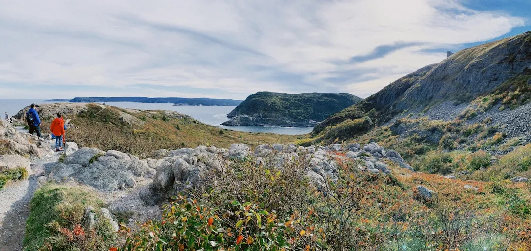
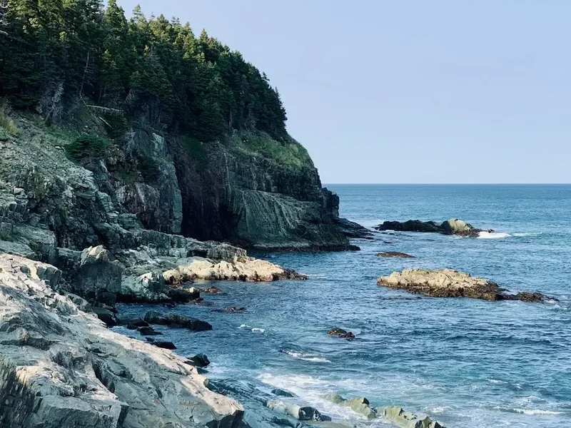
The East Coast Trail (ECT) is a spectacular 336 km long-distance hiking path that winds its way along the rugged Avalon Peninsula coastline of Newfoundland and Labrador, Canada. Stretching from Fort Amherst near St. John's to Cappahayden, this trail offers an unparalleled immersion into the raw beauty of the North Atlantic. It traverses dramatic sea cliffs, windswept headlands, secluded coves, and historic fishing villages, providing a constant panorama of ocean vistas, crashing waves, and abundant marine wildlife. The ECT is not a single, manicured path but a network of trails, old roads, and coastal routes, demanding a good level of fitness and navigational skill. It’s a journey that tests your resilience against the elements while rewarding you with breathtaking scenery and a profound connection to the wild Newfoundland coast.
- Distance: 336 km one-way
- Duration: 15–20 days
- Season: May–October
- Difficulty: Very Challenging
- Closest City: St. John's
- Trailhead Access: Nearest airport: St. John's International (YYT). From YYT, take a taxi or rent a car to Fort Amherst (start). Drive time ~20 mins. Parking available at Fort Amherst. Limited bus service. Trailhead GPS: 47.5615, -52.7126. No permits needed, but registration recommended at eastcoasttrail.com.
- Highest point: Varies significantly along the route, with numerous ascents and descents over coastal headlands.
- Daily walkers: No daily limit, but registration is encouraged.
- Direction: Primarily south to north, but can be hiked in sections or reverse.
Overview
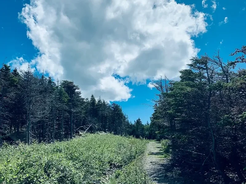
The East Coast Trail is a testament to Newfoundland's dramatic coastal geography and its rich maritime heritage. This extensive network of trails offers a challenging yet immensely rewarding thru-hike experience. Unlike more conventional national park trails, the ECT is a mosaic of paths, many of which are old footpaths used by generations of fishermen and villagers. This means the terrain is varied and often rugged, featuring steep ascents and descents over headlands, boggy sections through coastal barrens, and stretches of rocky shoreline.
The trail is renowned for its breathtaking ocean views. You'll walk along cliffs that plunge hundreds of metres to the churning sea below, offering prime vantage points for whale watching (especially in summer), iceberg spotting (in spring), and observing puffins and other seabirds. The constant sound of the ocean, the salty spray on your face, and the vast, uninterrupted horizon create an immersive experience that is both invigorating and humbling.
Beyond the natural beauty, the ECT is steeped in history. It passes through or near numerous small, picturesque fishing villages, many of which have a history stretching back centuries. These communities offer glimpses into a traditional way of life, with colourful houses, drying stages for fish, and a strong sense of local culture. Hikers can often find basic amenities like food and lodging in these villages, adding a unique cultural dimension to the trek.
The trail's difficulty is significant. The 6,200 metres of elevation gain are not concentrated in a few big climbs but are distributed across hundreds of smaller, steep ascents and descents. The weather is also a major factor; Newfoundland's coast is known for its fog, wind, and rain, which can change rapidly. Hikers must be prepared for all conditions, even in summer. Despite these challenges, the East Coast Trail offers an unforgettable adventure for those seeking a true wilderness experience combined with a deep dive into coastal Newfoundland culture.
History and Cultural Context
The Avalon Peninsula, where the East Coast Trail is situated, has a human history stretching back thousands of years. Indigenous peoples, including the Beothuk, inhabited the island, followed by early European explorers and settlers, primarily from England and Ireland, who established fishing communities along the coast. These communities relied heavily on the sea for their livelihood, and the paths that now form the ECT were often the only means of travel between villages or to reach prime fishing grounds.
The development of the East Coast Trail as a formal hiking route began in the late 20th century, driven by a desire to preserve and promote the region's natural and cultural heritage. The East Coast Trail Association (ECTA), a non-profit volunteer organisation, was formed in 1990 to maintain, develop, and promote the trail. Their dedicated work has transformed a collection of informal paths into a recognised long-distance hiking experience, while carefully preserving its wild character.
Many sections of the trail pass through or near historic fishing villages like Petty Harbour, Maddox Cove, and Bay Bulls. These communities, with their colourful houses, fishing boats, and traditional stages, offer a tangible link to Newfoundland's past. The trail also passes by numerous archaeological sites, remnants of earlier settlements, and even shipwrecks, hinting at the long and often perilous relationship between humans and the sea in this region.
The trail's route often follows old logging roads, cart tracks, and footpaths that were once vital arteries for these coastal communities. The preservation of these historic routes is a key aspect of the ECT's appeal, offering a journey not just through nature but through time, connecting hikers to the lives and struggles of those who have called this rugged coastline home for centuries.
Seasonal Highlights and Weather Reality
The East Coast Trail is a year-round destination, but its character and challenges vary significantly with the seasons. The primary hiking season is from May to October, when the weather is generally more favourable, though still unpredictable.
Spring (May–June): This is a spectacular time for wildlife viewing. Icebergs can often be seen drifting offshore, particularly in May and early June, creating a dramatic backdrop to the coastal scenery. Seabird colonies, including puffins, begin to return to their nesting sites, offering incredible viewing opportunities. The landscape starts to green up, though bogs and marshy areas can remain wet and challenging. Temperatures are cool, and fog is common.
Summer (July–August): This is the most popular hiking season. The weather is typically warmer, and daylight hours are long, allowing for extended hiking days. Whale watching is at its peak, with humpbacks, minke whales, and dolphins frequently spotted offshore. The coastal barrens bloom with wildflowers. However, summer also brings the highest numbers of sandflies and mosquitoes, which can be a significant nuisance. Fog remains a frequent occurrence, and rain showers are common.
Autumn (September–October): The fall colours can be stunning, with the coastal barrens turning shades of red, orange, and yellow. The insect population diminishes, making for more comfortable hiking. The weather can be crisp and clear, offering excellent visibility, but also increasingly prone to strong winds and colder temperatures. Snowfall is possible by late October, especially at higher elevations.
Winter (November–April): While not officially part of the main hiking season, the ECT can be traversed in winter by experienced individuals with appropriate winter gear and navigation skills. Snowshoeing or cross-country skiing may be possible on some sections, but the trail can be challenging to follow due to snow cover and the rugged terrain. Coastal storms can be severe, and conditions can be extremely hazardous. Access to some trailheads may be limited due to snow.
Weather Reality: It cannot be overstated that the weather on the Avalon Peninsula is highly variable and can change with little notice. Hikers should always be prepared for fog, strong winds, and rain, regardless of the season. Hypothermia is a risk even in summer due to wind chill and damp conditions. The trail's exposed coastal nature means that wind can be a constant and significant factor.
Recommended Itinerary
East Coast Trail Thru-Hike Itinerary (South to North)
This itinerary is a suggestion and can be adapted based on fitness, weather, and desired pace. It breaks the 336 km trail into manageable sections, averaging 15-20 km per day for a 15-20 day hike.
Day 1: Fort Amherst to Petty Harbour
- Distance: 15 km
- Elevation Gain: ~500 m
- Time: 4–6 hours
- Start at Fort Amherst, the historic gateway to St. John's Harbour.
- Follow the coastal path, passing Signal Hill National Historic Site (optional detour).
- Descend into the picturesque fishing village of Petty Harbour.
- Consider staying in Petty Harbour or continuing slightly further if time and energy permit.
Day 2: Petty Harbour to Maddox Cove
- Distance: 12 km
- Elevation Gain: ~450 m
- Time: 3–5 hours
- Continue south from Petty Harbour along the rugged coastline.
- Pass through scenic coves and over numerous small headlands.
- Arrive in the charming village of Maddox Cove.
Day 3: Maddox Cove to Bay Bulls
- Distance: 18 km
- Elevation Gain: ~650 m
- Time: 5–7 hours
- A longer day with significant elevation changes.
- The trail offers expansive ocean views and passes through coastal barrens.
- Arrive in the larger fishing town of Bay Bulls, known for its whale watching tours.
Day 4: Bay Bulls to Witless Bay
- Distance: 10 km
- Elevation Gain: ~350 m
- Time: 3–4 hours
- A shorter day, allowing for exploration of Witless Bay Ecological Reserve (puffin and guillemots).
- Consider a boat tour from Bay Bulls or Witless Bay for close-up wildlife encounters.
Day 5: Witless Bay to Mobile
- Distance: 14 km
- Elevation Gain: ~500 m
- Time: 4–6 hours
- Continue south along the coast, passing through more small communities.
- The terrain remains challenging with frequent ups and downs.
Day 6: Mobile to Branch
- Distance: 20 km
- Elevation Gain: ~700 m
- Time: 6–8 hours
- A substantial day covering a longer stretch of coastline.
- This section may involve more boggy terrain and exposed headlands.
Day 7: Branch to St. Mary's (via Point Lance)
- Distance: 25 km
- Elevation Gain: ~800 m
- Time: 7–9 hours
- A very challenging day, potentially requiring an early start.
- This section is remote and offers dramatic, unspoiled coastal scenery.
- Point Lance is a significant historical and geological site.
Day 8: St. Mary's to Salmonier Nature Park Area
- Distance: 18 km
- Elevation Gain: ~600 m
- Time: 5–7 hours
- The trail may move slightly inland in this area, potentially passing near Salmonier Nature Park.
- This section offers a change of scenery from the immediate coastline.
Day 9: Salmonier Nature Park Area to Colinet
- Distance: 16 km
- Elevation Gain: ~550 m
- Time: 4–6 hours
- Continue through varied terrain, potentially crossing more agricultural or barrens land.
Day 10: Colinet to Placentia
- Distance: 22 km
- Elevation Gain: ~750 m
- Time: 6–8 hours
- A longer day leading towards the historic town of Placentia.
- The trail may follow more established roads or paths in this region.
Day 11: Placentia to Argentia Area
- Distance: 15 km
- Elevation Gain: ~500 m
- Time: 4–6 hours
- Explore the historic significance of Placentia, a former French and British military outpost.
- The trail may skirt the Argentia naval base area.
Day 12: Argentia Area to Long Harbour
- Distance: 18 km
- Elevation Gain: ~600 m
- Time: 5–7 hours
- Return to more rugged coastal hiking as you move further north.
Day 13: Long Harbour to Ship Harbour
- Distance: 14 km
- Elevation Gain: ~500 m
- Time: 4–6 hours
- Continue along the eastern coastline, with more opportunities for wildlife spotting.
Day 14: Ship Harbour to Cappahayden
- Distance: 16 km
- Elevation Gain: ~550 m
- Time: 4–6 hours
- The final section of the main ECT, ending at Cappahayden.
- Celebrate the completion of your thru-hike!
Important Notes:
- This itinerary is a guideline; actual distances and times can vary significantly due to trail conditions and weather.
- Accommodation options are limited in some sections; plan your overnight stops carefully.
- Resupply points are scarce; plan your food and supplies meticulously.
- Water sources are generally plentiful but should be treated.
- Navigation skills are essential, especially in fog or poor weather.
- Be prepared for significant elevation changes daily.
Planning and Bookings
Book Your Trip
Everything you need to plan your journey
Accommodation
Find places to stay near St. John's
Flights
Search flights to St. John's
Essential Preparation
The East Coast Trail is a serious undertaking that requires meticulous planning. Unlike many well-established national park trails, the ECT is a wilderness route with limited infrastructure and resupply points. Your fitness level is paramount; you must be comfortable hiking long distances over challenging, uneven terrain with significant elevation changes daily. Many sections involve steep ascents and descents over rocky headlands, boggy traverses, and potentially muddy or slippery conditions. Carrying a heavy pack for extended periods will add to the challenge.
Logistics are critical. The trail stretches 336 km, and while it can be hiked in sections, a thru-hike requires careful consideration of transportation to the start and from the end, as well as potential resupply points along the way. St. John's is the closest major city and serves as the primary gateway. It offers comprehensive services, including gear shops, supermarkets, and accommodation. However, once you leave St. John's, services become sparse. Researching accommodation options in the small villages along the route is essential, as availability can be limited. Many hikers opt for a combination of camping and staying in local guesthouses or B&Bs.
Communication is also a consideration. Cell phone service is unreliable and often non-existent along large portions of the trail. Carrying a satellite communication device (like a SPOT or inReach) is highly recommended for safety and to inform others of your progress.
Trail Accommodation
Accommodation along the East Coast Trail is varied and often requires advance booking or flexibility. There are no designated "huts" in the same way as some other long-distance trails. Instead, hikers typically rely on a combination of:
- Camping: Wild camping is permitted in many areas, provided you follow Leave No Trace principles. Designated campsites are rare, so be prepared to find suitable spots in more remote sections. Some communities may have informal camping areas.
- Guesthouses and B&Bs: Many of the small fishing villages along the trail offer charming guesthouses or bed and breakfasts. These can provide a comfortable respite, a hot meal, and a chance to interact with locals. Booking well in advance is crucial, especially during peak season (July-August), as capacity is limited.
- Community Halls/Churches: In some villages, community halls or churches may offer basic shelter for hikers, sometimes for a small donation. This is less common and requires local inquiry.
- Private Rentals: Larger towns like Bay Bulls or Placentia may have vacation rentals available.
Booking Requirements: For guesthouses and B&Bs, booking is essential, often weeks or months in advance for popular locations. For camping, there are no formal booking requirements for wild camping, but always check local regulations and be mindful of private property. If planning to stay in villages, research specific accommodation providers and their booking procedures.
Facilities Provided: Guesthouses and B&Bs typically provide beds, linens, and breakfast. Camping facilities are usually limited to natural environments, meaning you must be self-sufficient.
What's NOT Provided: Huts, campsites, or informal shelters do not provide food, cooking equipment, electricity, or running water beyond natural sources. You must carry all your own food, cooking gear, and water treatment supplies.
Seasonal Availability: Most guesthouses and B&Bs operate from late spring through early autumn (May-October). Some may close outside of this period. Camping is possible year-round but becomes significantly more challenging and potentially hazardous in winter.
Costs: Costs vary widely. Camping is free (following LNT). Guesthouses and B&Bs can range from CAD$80-150+ per night, depending on the location and amenities.
This is a thru-hike requiring overnight accommodation.
Required Gear
- Sturdy Hiking Boots: Waterproof, broken-in boots with good ankle support are essential for the rugged and often wet terrain.
- Waterproof Outerwear: A high-quality waterproof and windproof jacket and trousers are non-negotiable. Expect rain and strong winds.
- Layered Clothing: Synthetic or merino wool base layers, insulating mid-layers (fleece or down), and a warm hat and gloves are necessary, even in summer.
- Backpack: A comfortable, well-fitting backpack of 50-70 litres capacity, with a rain cover.
- Navigation Tools: Detailed maps of the East Coast Trail (available from ECTA), a compass, and a GPS device or smartphone with offline mapping capabilities. Knowledge of how to use them is critical.
- Headlamp/Torch: With spare batteries. Essential for early starts, late finishes, or in case of unexpected delays.
- First-Aid Kit: Comprehensive kit including blister treatment, pain relievers, antiseptic wipes, bandages, and any personal medications.
- Sun Protection: Sunscreen, sunglasses, and a wide-brimmed hat. The sun can be intense, especially reflecting off the water.
- Insect Repellent: High-strength repellent (with DEET or Picaridin) is crucial, especially from June to August.
- Trekking Poles: Highly recommended for stability on steep ascents/descents and for reducing strain on joints.
- Water Filter/Purifier: Essential for treating water from natural sources.
- Emergency Shelter: A lightweight emergency bivy or space blanket.
What to Bring
- Food: Sufficient non-perishable food for the entire duration of your hike, plus extra for emergencies. Resupply points are infrequent and limited. Plan meals carefully, considering weight and nutritional value.
- Cooking Gear: Lightweight stove, fuel, pot, utensils, mug, and a lighter or waterproof matches.
- Water Bottles/Reservoir: Capacity for at least 2-3 litres.
- Toiletries: Biodegradable soap, toothbrush, toothpaste, toilet paper, trowel (for catholes if not using facilities), hand sanitiser.
- Repair Kit: Duct tape, cordage, safety pins, needle and thread for gear repairs.
- Personal Items: Camera, book, journal, power bank for electronics.
- Trash Bags: To pack out all your waste.
- Whistle: For signalling in emergencies.
- Cash: Some smaller communities may not accept credit cards.
Permits
No specific permits are required to hike the East Coast Trail itself. The trail is managed by the East Coast Trail Association (ECTA), a non-profit organisation, and is generally open to the public. However, registration with the ECTA is highly recommended. This helps them track hiker numbers, gather valuable feedback, and communicate important trail updates or alerts.
Registration:
- Visit the official East Coast Trail Association website (eastcoasttrail.com) to register your hike.
- Registration is free but strongly encouraged.
- It allows the ECTA to maintain a database of hikers, which is crucial for safety and trail management.
Other Considerations:
- Private Property: While the trail largely follows public land, there may be sections that cross private property. Always respect signage and private property rights.
- Ecological Reserves: Some sections of the trail pass through or near ecological reserves (e.g., Witless Bay Ecological Reserve). While access is generally permitted, be mindful of any specific regulations in place to protect wildlife.
- National Historic Sites: Sections near Signal Hill National Historic Site may have specific visitor regulations.
Booking Accommodation: While no permits are needed for the trail, booking accommodation in villages (guesthouses, B&Bs) is essential and should be done well in advance, especially during the peak summer season.
Other Activities in the Area
The Avalon Peninsula offers a wealth of activities beyond hiking the East Coast Trail, making it an ideal destination for a longer trip:
- Whale Watching Tours: Bay Bulls and Witless Bay are world-renowned for their whale watching opportunities. Take a boat tour to see humpbacks, minke whales, dolphins, and other marine life up close.
- Puffin and Seabird Watching: The Witless Bay Ecological Reserve is home to one of the largest Atlantic puffin colonies in North America, along with numerous other seabird species. Boat tours provide excellent viewing opportunities.
- Signal Hill National Historic Site: Located in St. John's, this iconic site offers panoramic views of the city and the harbour, and is where Guglielmo Marconi received the first transatlantic wireless signal.
- Explore St. John's: Discover North America's oldest city, with its colourful houses, vibrant nightlife, historic Jellybean Row, the Rooms (provincial museum and art gallery), and the Battery historic neighbourhood.
- Cape Spear National Historic Site: The easternmost point of North America, offering dramatic coastal views and a historic lighthouse.
- Iceberg Viewing: During spring (typically April-June), icebergs calved from Greenland glaciers drift down the coast, providing a spectacular natural phenomenon.
- Kayaking and Coastal Exploration: Explore the coastline by kayak, offering a unique perspective on sea caves, arches, and marine life.
- Fishing Villages: Visit charming and historic fishing villages like Petty Harbour, Maddox Cove, and Portugal Cove to experience local culture and scenery.
- Newfoundland T'Railway: For a different kind of adventure, explore sections of this former railway line, now a multi-use recreational trail, which runs across the island.
Safety and Conditions
Pre-Departure Checks:
- Weather: Always check the Newfoundland and Labrador weather forecast from Environment Canada and the MetService for the Avalon Peninsula. Be prepared for rapid changes, including fog, strong winds, and heavy rain.
- Trail Conditions: Consult the East Coast Trail Association website (eastcoasttrail.com) for any trail alerts, closures, or reported hazards. Volunteer trail maintainers work hard, but conditions can change due to weather or natural events.
- Tides: Some coastal sections may be affected by tides. Consult local tide charts if your route involves coastal walking where access could be cut off at high tide.
- Communication: Ensure your satellite communication device is charged and functional. Inform a reliable contact of your itinerary and expected check-in times.
Key Hazards:
- Weather: Fog can reduce visibility to near zero, making navigation extremely difficult. Strong winds can make exposed headlands treacherous. Hypothermia is a risk due to wind chill and damp conditions, even in summer.
- Terrain: Steep, slippery ascents and descents, loose rocks, boggy and muddy sections, and uneven coastal paths are common.
- Coastal Erosion: Some sections of the trail are subject to coastal erosion, which can create unstable ground or impassable areas. Always stay on marked trails and exercise caution near cliff edges.
- Wildlife: While large predators are rare, be aware of your surroundings. Moose can be encountered inland, and marine life is abundant offshore.
- Insects: Black flies and mosquitoes can be intense from June to August.
- Isolation: Many sections of the trail are remote with limited access and no cell service. Be prepared to be self-sufficient.
Safety Recommendations:
- Hike with a Buddy: If possible, hike with at least one other person.
- Carry a Map and Compass: And know how to use them. Do not rely solely on electronic devices.
- Stay on Marked Trails: To avoid getting lost and to protect fragile vegetation.
- Inform Someone of Your Plans: Leave a detailed itinerary with a trusted contact.
- Carry Sufficient Food and Water: And a way to treat water.
- Be Prepared for Emergencies: Carry a well-stocked first-aid kit and a satellite communication device.
- Respect the Environment: Follow Leave No Trace principles.
Travel insurance is strongly recommended to cover potential medical emergencies, evacuation, and trip cancellations.
Side Trips and Points of Interest
Witless Bay Ecological Reserve: Accessible from the trail near Witless Bay, this reserve is a haven for seabirds. Take a boat tour from Bay Bulls or Witless Bay to witness thousands of puffins, murres, kittiwakes, and guillemots. The sheer cliffs and bustling bird colonies are a photographer's dream.
Signal Hill National Historic Site: A short detour from the start of the trail in St. John's, Signal Hill offers historical significance and unparalleled views of the city and the Atlantic Ocean. The Cabot Tower is a prominent landmark.
Petty Harbour: A picturesque and historic fishing village, Petty Harbour is a great place to stop, observe traditional fishing practices, and enjoy the scenery. The trail passes right through it.
Point Lance: Located on a remote section of the trail, Point Lance is a significant geological and historical site. It features unique geological formations and evidence of past human activity, offering a glimpse into the area's ancient past.
Cape Spear National Historic Site: While not directly on the ECT, it's a worthwhile detour from the southern sections. It's the easternmost point of North America and features a historic lighthouse and dramatic coastal vistas.
Historic Fishing Villages: Many villages along the route, such as Maddox Cove, Bay Bulls, Mobile, and Placentia, are points of interest in themselves. Their colourful houses, stages, and harbours offer a rich cultural experience and photo opportunities.
Coastal Headlands: The numerous headlands that punctuate the trail are points of interest for their dramatic cliffs, sweeping ocean views, and opportunities for wildlife spotting (whales, icebergs, seabirds).
Leave No Trace
The East Coast Trail traverses a fragile coastal ecosystem and passes through communities that rely on its natural beauty. Adhering to Leave No Trace (LNT) principles is paramount to preserving this environment for future hikers and for the local communities.
Your responsibility as a hiker:
- Plan Ahead and Prepare: Research the trail, know your route, and be prepared for the conditions. This includes carrying appropriate gear and sufficient food and water.
- Travel and Camp on Durable Surfaces: Stick to the marked trail. If camping, choose established sites or durable surfaces like rock or dry grass, well away from water sources. Avoid trampling vegetation.
- Dispose of Waste Properly: Pack out everything you pack in, including all food scraps, wrappers, and toilet paper. Use designated toilets where available, or dig catholes at least 70 metres from water sources, trails, and campsites.
- Leave What You Find: Do not remove natural objects (rocks, plants, shells) or cultural artifacts.
- Minimize Campfire Impacts: Campfires are generally discouraged on the ECT due to the risk of wildfire and the impact on vegetation. If absolutely necessary and permitted, use existing fire rings and ensure fires are completely extinguished.
- Respect Wildlife: Observe wildlife from a distance. Never feed animals, as it can harm their health and alter their natural behaviour. Store food securely to prevent attracting animals.
- Be Considerate of Other Visitors: Keep noise levels down, yield to other hikers, and respect the peace and quiet of the trail and communities.
The East Coast Trail Association relies on volunteers to maintain the trail. By practicing LNT, you contribute to the preservation of this incredible resource.
Useful Links
- East Coast Trail Association (ECTA) - Official Website
- ECTA - Trail Alerts and Closures
- Environment Canada - Weather Forecasts
- Newfoundland and Labrador Tourism
- Terra Nova National Park (for broader Newfoundland nature info)
- Signal Hill National Historic Site
- Bay Bulls Whale Watching
- Witless Bay Ecological Reserve Information