Eagle Creek Trail to Tunnel Falls - A Masterpiece of the Columbia River Gorge
The Eagle Creek Trail to Tunnel Falls is arguably the most spectacular day hike in the Pacific Northwest of the United States. Carved directly into the basalt cliffs of the Columbia River Gorge, this 19.3 km return journey offers an unparalleled immersion into a landscape defined by temperate rainforest, sheer canyon walls, and a density of waterfalls that feels almost supernatural. The trail is a marvel of early 20th-century engineering, featuring sections blasted into cliff faces where hikers grip steel cables for security while peering down into the turquoise pools of Eagle Creek hundreds of metres below. The ultimate destination, Tunnel Falls, provides one of the most iconic hiking experiences in North America: a trail that passes directly behind a thundering 50-metre curtain of water via a hand-blasted rock tunnel. This is a walk that demands a steady head for heights, a deep appreciation for geological drama, and a respect for the power of natural regeneration following the transformative Eagle Creek Fire of 2017.
- Distance: 19.3 km return
- Duration: 6–8 hours
- Elevation Gain: 487 m
- Difficulty: Moderate (due to distance and narrow cliff-side sections)
- Best Time: May to October (late spring for peak water flow, autumn for colour)
- Closest City: Portland, Oregon (approx. 70 km / 1 hour drive)
- Trailhead: Eagle Creek Campground/Trailhead, Exit 41 off I-84
Overview
Located within the Columbia River Gorge National Scenic Area, the Eagle Creek Trail is a sensory odyssey through one of the most ecologically diverse regions in Oregon. The trail follows the path of Eagle Creek as it carves its way through layers of ancient basalt, deposited millions of years ago by massive volcanic flows. What distinguishes this trail from others in the region is its relentless verticality and the sheer number of named and unnamed waterfalls encountered along the route. From the moss-draped amphitheatre of Metlako Falls to the perfectly circular basin of Punch Bowl Falls, the journey is a constant crescendo of hydraulic power and verdant beauty.
The landscape is currently in a fascinating state of transition. In September 2017, a human-caused wildfire swept through the canyon, significantly altering the forest structure. While the "emerald cathedral" of old-growth Douglas fir and western red cedar was thinned in sections, the resulting mosaic of scorched snags and vibrant new growth offers a profound lesson in forest ecology. Hikers today witness the resilience of nature: fireweed and elderberry colonising the forest floor, while the towering basalt cliffs—unaffected by the flames—remain as stoic as ever. The trail itself, which was closed for over three years for extensive repairs to bridges and cable railings, has been meticulously restored, allowing safe passage through this rugged terrain.
The experience of walking the Eagle Creek Trail is defined by its "ledge sections." In several places, the path is less than two metres wide, with a vertical rock wall on one side and a sheer drop to the creek on the other. While steel cables are bolted into the rock for safety, the exposure is genuine. This is not a trail for those with severe vertigo, but for the prepared hiker, it offers a perspective on the canyon that is intimate and exhilarating. The culmination of the hike at Tunnel Falls is a bucket-list moment, where the trail disappears into the cliffside, emerging behind the waterfall's roar before continuing toward the equally impressive Twister Falls just a few hundred metres further upstream.
History and Cultural Context
The history of the Eagle Creek Trail is inextricably linked to the development of the Columbia River Highway, the first scenic highway in the United States. In the early 1910s, visionary engineers like Samuel Lancaster and developers like Simon Benson sought to create a "King of Roads" that would rival the great scenic drives of Europe. As part of this grand vision, the United States Forest Service began constructing the Eagle Creek Trail in 1915 to provide recreational access to the canyon's interior. It was the first forest trail in the nation designed specifically for recreation rather than resource management or fire access, marking a pivotal shift in how Americans viewed their wilderness areas.
The construction was an immense undertaking. Workers used dynamite to blast ledges into the vertical basalt walls, and the iconic tunnel behind Tunnel Falls was hand-drilled and blasted through the solid rock. The craftsmanship is still evident today in the stone masonry of the older bridges and the deliberate pacing of the trail's gradient. For decades, Eagle Creek served as the flagship trail of the Pacific Northwest, drawing thousands of visitors who arrived by train or early motorcar to marvel at the "Grand Canyon of the Columbia."
Long before European surveyors arrived, the area was of great importance to the indigenous peoples of the Columbia River, including the Wasco, Wishram, and Sahaptin-speaking tribes. The creek and the surrounding forest provided rich resources, from salmon in the lower reaches to berries and game in the uplands. The 2017 fire, while devastating to modern infrastructure, is part of a much longer cycle of fire and renewal that these landscapes have experienced for millennia. Today, the trail is managed by the U.S. Forest Service, and its ongoing maintenance is a testament to the enduring value placed on public access to these extraordinary natural monuments.
Want more background? Read extended notes on history and cultural context → Learn more
Seasonal Highlights and Weather Reality
The Columbia River Gorge creates its own microclimate, often acting as a funnel for weather systems moving between the Pacific Coast and the arid interior of Eastern Oregon. This results in high precipitation and unique seasonal shifts that dramatically change the character of the Eagle Creek Trail.
Spring (March to May): This is the season of maximum hydraulic power. As snow melts in the Hatfield-Jackson Wilderness and spring rains saturate the moss, the waterfalls reach their peak volume. The mist from Tunnel Falls can be felt hundreds of metres away, and the creek turns a vibrant, churning turquoise. Wildflowers, including the endemic Columbia Gorge balsamroot and various species of trillium, begin to carpet the forest floor. However, this is also the wettest time to hike; trails can be muddy, and the cliff sections require extra caution as the rock surfaces become slippery.
Summer (June to August): The most popular time for the trail. The canopy provides welcome shade, and the air temperature in the canyon is often several degrees cooler than in nearby Portland. The water levels drop, making the pools at Punch Bowl Falls popular for a refreshing (though very cold) dip. The risk of thunderstorms is low, but this is the peak season for crowds. Arriving at the trailhead before 7:30 AM is essential to secure a parking space.
Autumn (September to November): As the heat of summer fades, the bigleaf maples and vine maples in the canyon turn brilliant shades of gold and orange. The contrast between the yellow leaves, the dark basalt, and the evergreen Douglas firs is a photographer's dream. Rainfall begins to increase in October, revitalising the waterfalls that may have thinned during the dry summer months. This is arguably the most comfortable time for the long 19.3 km trek.
Winter (December to February): Winter in the Gorge is unpredictable. While the trail is at a low elevation, cold easterly winds can cause "silver thaws"—freezing rain that coats the trail and cables in thick ice. During these periods, the trail becomes extremely dangerous and is often effectively impassable without technical ice gear (crampons and ice axes). However, on mild winter days, the lack of foliage offers clearer views of the canyon's geological structure, and the solitude is profound.
Recommended Itinerary
Eagle Creek to Tunnel Falls Route Progression
0.0 km to 3.2 km: The Lower Canyon
- Trailhead Start: Begin at the Eagle Creek Trailhead (ensure your Northwest Forest Pass is displayed). The trail starts with a gentle climb through a forest of Douglas fir and western hemlock.
- Metlako Falls Overlook (2.4 km): A short, signed spur trail leads to a viewpoint of Metlako Falls. Dropping 30 metres into a narrow, mossy gorge, it is named after a legendary Nez Perce deity. The view is framed by towering basalt columns.
- Punch Bowl Falls (3.2 km): One of the most photographed waterfalls in Oregon. The trail offers a high-point view of the falls dropping into a perfectly circular basalt "bowl." A lower spur trail (when open) allows you to walk down to the creek level for a head-on perspective.
3.2 km to 7.7 km: The Middle Canyon and High Bridge
- Loowit Falls: Shortly after Punch Bowl, you will see Loowit Falls across the canyon, a delicate veil of water sliding down the far wall.
- High Bridge (5.3 km): A major milestone. The trail crosses a sturdy steel bridge suspended 36 metres above a narrow slot canyon. Looking down, you can see the power of the water as it has carved a deep, dark flume through the rock. This is a great spot for a quick snack.
- 4-1/2 Mile Bridge (7.2 km): The trail crosses back to the east side of the creek. The forest here shows more significant signs of the 2017 fire, with silver snags standing against the sky and a lush understory of ferns and huckleberries.
7.7 km to 9.6 km: The Ledges and Tunnel Falls
- The Ledges: The trail becomes narrower and is blasted directly into the cliffside. Steel cables are provided for handholds. The views into the upper canyon are expansive and dramatic.
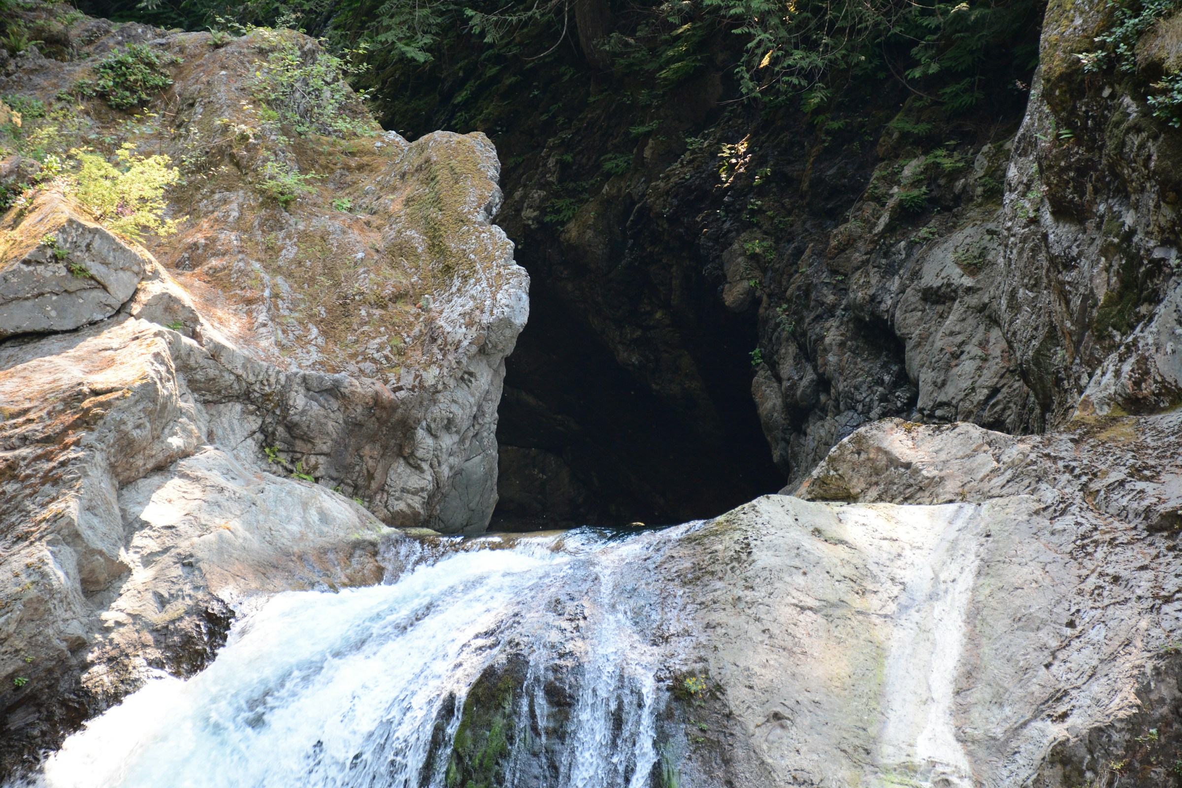
- Tunnel Falls (9.6 km): The climax of the hike. The trail rounds a corner to reveal a massive amphitheatre where Eagle Creek plunges 50 metres. The trail leads directly into a tunnel behind the falls. Take your time here; the sound and spray are immersive.
- Twister Falls (9.9 km): Just 300 metres past Tunnel Falls is Twister Falls (also known as Eagle Creek Falls). Here, the water "twists" through a narrow basalt chute before dropping. It is a spectacular spot to mark your turnaround point.
9.6 km to 19.3 km: The Return Journey
- Retrace your steps back down the canyon. The perspective on the return leg often reveals waterfalls and rock formations you missed on the way up.
- The final 3 km can feel long on tired legs; ensure you have saved enough water for the descent.
- Arrive back at the trailhead and celebrate a successful completion of one of the world's great day walks.
Important Notes:
- This is a long day hike; start early to avoid finishing in the dark.
- The trail is narrow; always yield to uphill hikers and be patient at cable sections.
- Keep dogs on a leash at all times—the cliff drops are fatal for pets.
- Check the Forest Service website for any temporary closures due to rockfall or trail maintenance.
Planning and Bookings
Book Your Trip
Everything you need to plan your journey
Accommodation
Find places to stay near Portland, Oregon
Flights
Search flights to Portland, Oregon
Essential Preparation
The Eagle Creek Trail is a demanding day hike that requires a moderate level of physical fitness. While the elevation gain is relatively gradual (487 m over nearly 10 km), the total distance of 19.3 km and the uneven, rocky terrain can be taxing on the joints. Hikers should be comfortable walking for 6 to 8 hours and have a steady footing for the narrow cliff sections.
Logistically, the trail is easily accessible from Portland, Oregon. Most hikers base themselves in the city or in the nearby towns of Cascade Locks or Hood River. Because the trailhead parking lot is small and extremely popular, "booking" your arrival time is effectively done by arriving early—ideally before 8:00 AM on weekdays and 7:00 AM on weekends. If the main lot is full, do not park illegally on the entrance road, as towing is frequent and strictly enforced.
Trail Accommodation
This is a day hike requiring no overnight accommodation on the trail itself. Camping is strictly prohibited within the first 12 kilometres of the Eagle Creek Trail to protect the fragile riparian environment and the high-use recreation area. For those wishing to stay nearby, several options exist:
- Eagle Creek Campground: Located right at the trailhead, this is the oldest Forest Service campground in the US. It offers basic sites with fire rings and picnic tables. Bookings are essential and can be made via Recreation.gov.
- Cascade Locks: Just 5 minutes east, this town offers motels, guesthouses, and the Marine Park campground. It is a popular hub for Pacific Crest Trail (PCT) hikers.
- Dispersed Camping: For multi-day backpackers continuing past Twister Falls into the Hatfield-Jackson Wilderness, dispersed camping is permitted at designated sites (such as 7-1/2 Mile Camp), but these are well beyond the Tunnel Falls day-hike turnaround.
Required Gear
- Footwear: Sturdy hiking boots or trail runners with excellent grip (Vibram soles recommended). The basalt rock can be very slippery when wet.
- Clothing: Moisture-wicking layers. Even in summer, the canyon can be cool and damp. A lightweight fleece or wool mid-layer is advised.
- Rain Gear: A high-quality waterproof jacket is essential. The Columbia River Gorge is famous for sudden rain showers, and the spray from Tunnel Falls will soak you if you linger.
- Navigation: A physical map or a downloaded offline GPS map (e.g., AllTrails or Gaia GPS). While the trail is well-marked, fire damage can sometimes make spur trails confusing.
- Safety: A basic first aid kit, including blister plasters and an emergency whistle.
What to Bring
- Water: At least 2–3 litres per person. While you are walking next to a creek, the water must be treated for Giardia and Cryptosporidium. A portable filter (like a Sawyer Squeeze) is a great lightweight option.
- Food: High-energy snacks (nuts, dried fruit, energy bars) and a substantial lunch to enjoy at Tunnel Falls.
- Sun Protection: Sunscreen and a hat. While much of the trail is shaded, the fire-thinned sections are now quite exposed to the sun.
- Illumination: A head torch with extra batteries, just in case your hike takes longer than expected and you lose daylight.
- Permit: Your Northwest Forest Pass or a digital day-use permit (see Permits section).
Permits
To hike the Eagle Creek Trail, you must have a valid recreation pass displayed in your vehicle. The most common is the Northwest Forest Pass, which costs US$5 for a day or US$30 for an annual pass. This pass covers all National Forest trailheads in Oregon and Washington. Alternatively, the "America the Beautiful" Interagency Pass is also accepted.
Seasonal Day-Use Permits: Due to extreme popularity and the need to manage trail capacity, the U.S. Forest Service has occasionally implemented a seasonal permit system (typically from late May through early September). When active, these permits must be reserved in advance via Recreation.gov for a small processing fee (usually US$2). Always check the official Columbia River Gorge National Scenic Area website before your trip to see if a timed-entry permit is required for your specific dates.
Backcountry Permits: If you intend to camp overnight in the wilderness areas beyond the day-hike limits, you must fill out a free self-issue wilderness permit, usually available at the trailhead or at the boundary of the Hatfield-Jackson Wilderness.
Other Activities in the Area
The Columbia River Gorge is a world-class destination for outdoor recreation. Consider these nearby attractions to round out your trip:
- Multnomah Falls: Located just 15 minutes west, this is Oregon's tallest waterfall (189 m). It is highly accessible but requires a separate timed-entry reservation during peak months.
- Bonneville Lock and Dam: Visit the fish ladders to see salmon and steelhead migrating upstream, and meet "Herman," the famous 3-metre-long sturgeon at the Oregon Department of Fish and Wildlife sturgeon centre.
- Cascade Locks: Visit the Bridge of the Gods, a massive cantilever bridge that carries the Pacific Crest Trail across the Columbia River. The town is also famous for its ice cream shops—a perfect post-hike treat.
- Hood River: A 20-minute drive east brings you to the windsurfing and kiteboarding capital of the world. The town is also the gateway to the "Fruit Loop," a scenic drive through orchards and vineyards with spectacular views of Mount Hood.
- Thunder Island Brewing: A popular spot in Cascade Locks for hikers to gather and share stories over locally crafted beers and views of the river.
Safety and Conditions
Cliff Exposure: The most significant hazard on the Eagle Creek Trail is the sheer drop-offs. In several sections, the trail is narrow with no guardrails, only a cable bolted to the wall. These sections can be terrifying for those with a fear of heights. Always keep to the "wall side" of the trail when passing others, and never run or engage in horseplay near the edges.
Post-Fire Hazards: Although the trail has been cleared, the 2017 fire has left lasting impacts. Be aware of "snags" (standing dead trees) that can fall without warning, especially during high winds. Increased erosion also means that rockfalls are more common. If you hear a loud "crack" or the sound of tumbling rocks, move quickly to a protected area if possible.
Slippery Surfaces: The basalt rock of the Gorge is notoriously slick when wet. Even on a sunny day, the mist from waterfalls can create "black ice" conditions on the trail or make the rocky path feel like walking on grease. Wear footwear with aggressive tread and take short, deliberate steps.
Water Safety: Eagle Creek is fast-moving and cold. While the pools at Punch Bowl Falls look inviting, the current can be deceptive, and the water temperature is low enough to cause cold-water shock even in summer. Never jump from cliffs into the water; submerged logs and rocks shift constantly and have caused numerous spinal injuries and fatalities.
Communication: There is no mobile phone reception once you enter the canyon. If you have an emergency, you will need to rely on other hikers to carry a message out or use a satellite communication device (like a Garmin inReach). Always tell someone your expected return time before you start.
Side Trips and Points of Interest
Twister Falls: Located just 300 metres past Tunnel Falls, this is a "must-see" if you have made it that far. The creek makes a sharp 90-degree turn through a narrow flume, creating a unique "twisting" effect. The trail here is particularly dramatic, carved into a vertical wall with a cable handrail.
Punch Bowl Falls Lower Viewpoint: While the main trail stays high, a spur trail leads down to the creek bed. From here, you can see the classic "punch bowl" shape of the falls and the deep emerald pool. It is a much more intimate experience than the high-point overlook, though the trail can be flooded during high water.
The "Potholes": Along the creek, you will notice perfectly circular holes carved into the basalt. These are "potholes" created over centuries by stones caught in eddies, swirling around and grinding into the bedrock. They are fascinating examples of the power of fluvial erosion.
Hatfield-Jackson Wilderness: For those with extra energy, continuing past Twister Falls leads you into the heart of the wilderness. The crowds disappear almost instantly, and the forest becomes denser and more primitive. This is the gateway to the high country of the Columbia River Gorge.
Leave No Trace
The Eagle Creek Trail is a high-use area that requires every visitor to practice Leave No Trace principles to ensure its survival for future generations. The ecosystem is still recovering from the 2017 fire and is particularly vulnerable to human impact.
Key Responsibilities:
- Pack it in, pack it out: This includes all food scraps (even orange peels and apple cores), tissues, and pet waste. There are no rubbish bins on the trail.
- Stay on the trail: Cutting switchbacks or creating "social trails" to get a better photo causes massive erosion and destroys the fragile mosses and wildflowers that are trying to recolonise the fire-damaged soil.
- Respect the Water: Do not use soap (even biodegradable soap) in the creek. If you need to wash, carry water 60 metres away from the creek.
- Human Waste: Use the toilets at the trailhead before you start. If you must go on the trail, dig a "cathole" at least 15–20 cm deep and at least 60 metres from the water and the trail. Pack out your toilet paper in a sealed plastic bag.
- No Drones: Drones are prohibited in designated Wilderness areas and are highly discouraged on the rest of the trail as they disturb wildlife and the peace of other hikers.