Drakensberg Traverse - The Dragon's Backbone
The Drakensberg Traverse, specifically the northern section from the Sentinel to Cathedral Peak, is South Africa's most formidable mountain experience. Spanning approximately 65.0 kilometres across the high-altitude basalt ramparts of the uKhahlamba-Drakensberg Park, this trek is a journey through a UNESCO World Heritage site of staggering proportions. Known to the Zulu people as uKhahlamba (the Barrier of Spears) and to the early Dutch settlers as the Drakensberg (the Dragon Mountains), this landscape is defined by sheer vertical drop-offs of over 1,000 metres, vast alpine plateaus, and the world's second-highest waterfall. This is not a trail in the traditional sense; there are no waymarks, few established paths, and no permanent shelters on the escarpment. It is a pure wilderness experience that demands exceptional navigation skills, physical resilience, and a deep respect for the volatile mountain weather that can transform a sunny morning into a life-threatening blizzard within minutes.
- Distance: 65.0 km (approximate, depending on route choice)
- Duration: 4–6 days
- Season: April–May and September–October (avoiding summer storms and winter snow)
- Accommodation: Wild camping and natural caves (no huts on the escarpment)
- Highest point: Mount Aux Sources / Escarpment Edge (approx. 3,282 m)
- Elevation Gain: 3,000 m total ascent
- Difficulty: Very Challenging (requires off-trail navigation and high-altitude experience)
- Direction: Generally North to South (Sentinel to Cathedral Peak)
Overview
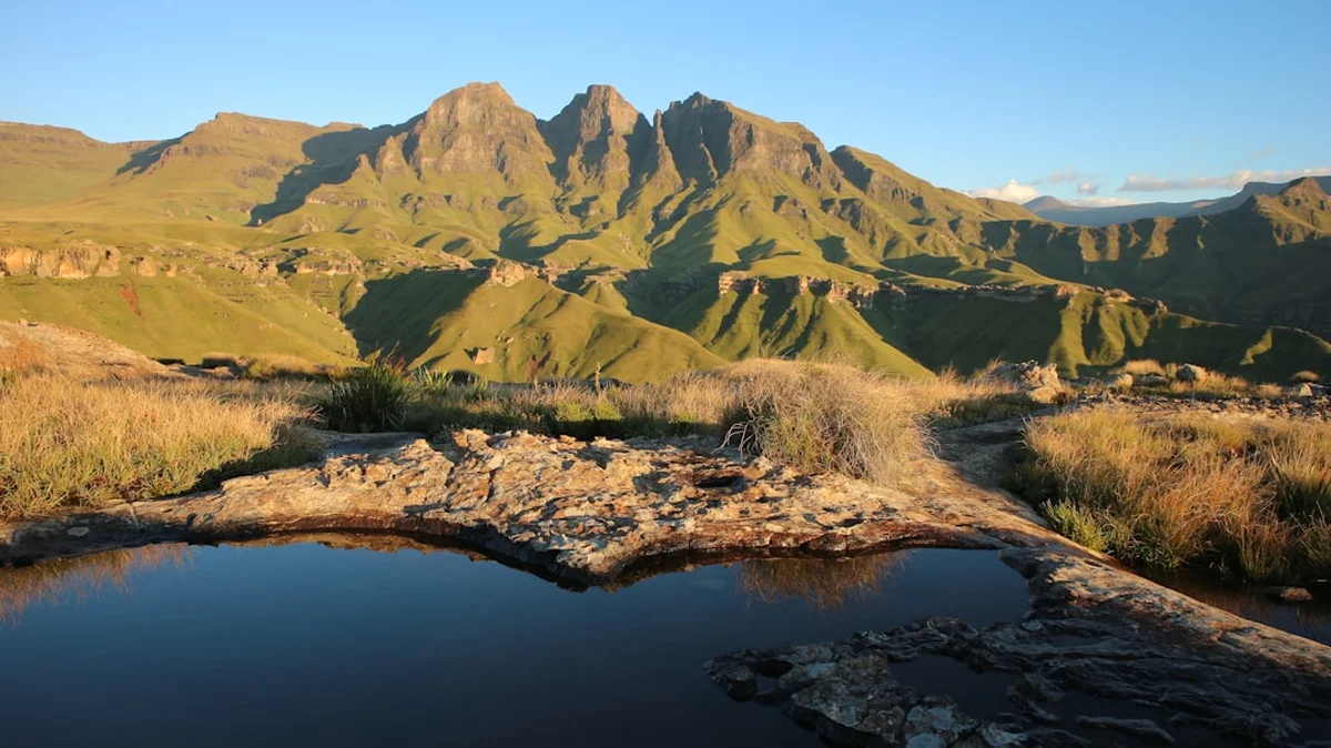
The Drakensberg Traverse is often cited as one of the world's greatest multi-day treks, yet it remains remarkably wild and uncommercialised. Unlike the Great Walks of New Zealand or the established routes of the European Alps, the "Berg" offers a raw, unmediated connection to the landscape. The 65-kilometre route from the Sentinel Car Park to the Cathedral Peak Hotel traverses the "Northern Berg," a section famous for its dramatic "Cutbacks"—deep, horseshoe-shaped valleys carved into the basalt cliffs that force the hiker to weave along the very edge of the abyss.
The journey begins with the iconic Chain Ladders, a series of vertical steel rungs bolted into the rock face that provide the only viable access to the Amphitheatre plateau. Once atop the plateau, the world opens into a vast, undulating grassland that sits at an average elevation of 3,000 metres. To the east, the land simply vanishes, dropping vertically into the valleys of KwaZulu-Natal. To the west, the rolling hills of the Lesotho Highlands stretch toward the horizon. This duality—the terrifying verticality of the edge and the serene isolation of the interior—defines the character of the traverse.
Walking the Drakensberg is a lesson in geology and scale. The mountains are composed of a massive layer of basalt, up to 1,400 metres thick, which sits atop a base of softer Clarens sandstone. This structure creates the characteristic "Little Berg" (the sandstone foothills) and the "Main Berg" (the basalt peaks). On the traverse, you are walking on the roof of Southern Africa. You will encounter the Tugela Falls, which plunges 948 metres in five clear leaps, and pass beneath peaks with evocative names like the Madonna and Her Helpers, the Mnweni Needles, and the Column and the Pyramid. This is a landscape of extremes, where the silence is broken only by the wind, the cry of a Jackal Buzzard, or the distant thunder of a summer storm.
History and Cultural Context
The human history of the Drakensberg is as layered as its geology. For thousands of years, the mountains were the sanctuary of the San (Bushmen) people. These hunter-gatherers found shelter in the sandstone caves of the lower valleys, leaving behind a legacy of rock art that is considered among the finest in the world. There are over 600 known rock art sites in the uKhahlamba-Drakensberg Park, containing upwards of 35,000 individual images. These paintings depict not only the wildlife of the region—particularly the Eland, which held deep spiritual significance—but also the complex rituals and daily lives of the San. While the traverse stays primarily on the high basalt escarpment where caves are fewer and art is rare, the presence of the San is felt in the very names of the peaks and the ancient spirit of the wilderness.
In the 19th century, the mountains became a site of conflict and migration. The Zulu Kingdom, under King Shaka, expanded its influence across the plains below, while the Voortrekkers (Dutch settlers) attempted to cross the formidable barrier with their wagons in search of new lands. The name "uKhahlamba" reflects the Zulu perception of the range as a defensive wall of spears, a barrier that protected the heartland of KwaZulu. Later, the mountains served as a refuge for various groups during the turbulent years of the Mfecane and the Anglo-Boer Wars.
Today, the escarpment marks the international border between the Republic of South Africa and the Kingdom of Lesotho. Hikers on the traverse will frequently encounter Basotho shepherds, who live in small stone huts (motebos) and graze their flocks of sheep and goats on the high-altitude pastures. These encounters offer a glimpse into a way of life that has remained largely unchanged for generations, though hikers are advised to maintain a respectful distance and be aware of the cultural nuances of the border region. The uKhahlamba-Drakensberg Park was declared a UNESCO World Heritage site in 2000, recognising both its exceptional natural beauty and its irreplaceable cultural heritage.
Want more background? Read extended notes on history and cultural context → Learn more
Seasonal Highlights and Weather Reality
The Drakensberg is a mountain range of fierce meteorological extremes. Understanding the seasonal cycles is critical for safety and enjoyment. Unlike many mountain ranges where summer is the default hiking season, the Drakensberg summer (December to February) is arguably the most dangerous time to be on the escarpment.
Autumn (April to May): This is widely considered the "Golden Window" for the traverse. The fierce summer thunderstorms have subsided, the air is crisp and clear, and the landscape is still lush and green. Daytime temperatures are pleasant for walking (15°C to 20°C), though night-time temperatures on the escarpment will frequently drop below freezing. This season offers the best stability and the most reliable visibility for navigation.
Winter (June to August): Winter in the Berg is dry, brown, and bitterly cold. While the skies are often a brilliant, cloudless blue, the wind can be relentless. Snowfalls are common and can be heavy, burying the few existing paths and making navigation extremely difficult. Temperatures on the escarpment can plummet to -15°C at night. Only experienced winter mountaineers with appropriate four-season gear should attempt the traverse during these months.
Spring (September to October): Another excellent window, though more volatile than autumn. The first rains begin to turn the brown slopes green, and the wildflowers start to bloom. However, this is also the season of the "Berg Winds"—hot, dry winds from the interior that can reach gale force and are often followed by sudden, violent cold fronts and snow.
Summer (November to March): Summer is the season of the Great African Thunderstorm. Almost every afternoon, massive cumulonimbus clouds build up over the escarpment, resulting in violent electrical storms, torrential rain, and hail. Lightning is a very real and lethal threat on the exposed plateau. Furthermore, thick mist (the "Berg Mist") can descend in minutes, reducing visibility to less than five metres and making navigation impossible without a GPS. While the waterfalls are at their most spectacular, the risks are significantly higher.
Recommended Itinerary
5-Day Northern Drakensberg Traverse Itinerary
Day 1: Sentinel Car Park to Tugela Falls
- Distance: 10 km
- Elevation gain: 600 m
- Time: 4–5 hours
- Start at the Sentinel Car Park (2,500 m) and follow the well-maintained path beneath the Sentinel Peak
- Ascend the famous Chain Ladders (two sections of vertical steel ladders) or take the alternative Beacon Buttress gully
- Arrive at the Amphitheatre plateau and walk to the lip of the Tugela Falls
- Camp near the Tugela River, ensuring you are at least 50 metres from the edge
- This is a relatively short day to allow for acclimatisation to the 3,000 m altitude
Day 2: Tugela Falls to Ifidi Stope
- Distance: 14 km
- Elevation gain: 400 m
- Time: 6–7 hours
- Walk south along the escarpment edge, crossing the Bilanjil River
- Navigate around the "Western Buttress" and the "Mount-Aux-Sources" peak
- The terrain becomes more rugged with no formal paths; navigation skills are essential here
- Pass the dramatic "Madonna and Her Helpers" rock formations
- Camp near the head of the Ifidi Stope or in the Ifidi Cave (if available)
- Spectacular views of the Ifidi Pinnacles and the sheer drop into the Mnweni valley
Day 3: Ifidi Stope to Mnweni Area (Upper Mnweni Cave)
- Distance: 15 km
- Elevation gain: 500 m
- Time: 7–8 hours
- This is the heart of the "Mnweni Cutback," arguably the most beautiful section of the Berg
- The route weaves in and out of deep valleys, staying as close to the edge as safety permits
- Pass the "Hanging Valleys" and the "Mnweni Needles"
- Cross the high point near the Mponjwane peak (3,112 m)
- Locate the Upper Mnweni Cave for a night of "cave camping" or pitch tents on the grassy flats nearby
- The Mnweni area is remote and wild, with frequent sightings of Bearded Vultures (Lammergeiers)
Day 4: Mnweni Area to Rockeries / Orange Peel Gap
- Distance: 13 km
- Elevation gain: 400 m
- Time: 6–7 hours
- Continue south toward the "Rockeries," a series of jagged basalt towers
- Pass the "Cape Eagle" and "Ledges" areas
- The navigation becomes tricky as you move toward the Cathedral Peak range
- The views of the "Inner and Outer Horns" and "The Column" are world-class
- Camp near the top of the Rockeries Pass or push toward the Orange Peel Gap area
- Be aware of Basotho shepherd activity in this region; keep a tidy camp
Day 5: Rockeries to Cathedral Peak Hotel (Descent)
- Distance: 13 km
- Elevation loss: 1,400 m
- Time: 6–8 hours
- Begin the long, knee-jarring descent from the escarpment
- The most common route is via the Rockeries Pass or the Mlambonja Pass
- The path descends through the basalt cliffs into the sandstone "Little Berg"
- Pass through beautiful Protea savannah and cross the Mlambonja River
- Finish at the Cathedral Peak Hotel or the Ezemvelo KZN Wildlife office
- Celebrate with a cold drink and a view of the peaks you just traversed
Important Notes:
- There are no marked trails on the escarpment; a GPS and 1:50,000 maps are mandatory
- Water can be scarce in the dry season; plan camp spots near known river sources
- The descent on Day 5 is extremely steep and requires good weather for safety
- Always sign the mountain register at the start and end of the trek
Planning and Bookings
Book Your Trip
Everything you need to plan your journey
Accommodation
Find places to stay near Durban
Flights
Search flights to Durban
Essential Preparation
The Drakensberg Traverse is a serious undertaking that requires significant physical and logistical preparation. Hikers must be in excellent physical condition, as carrying a 15–20 kg pack at 3,000 metres elevation is taxing. Cardiovascular fitness and leg strength are paramount for the steep ascents and descents.
Logistically, the traverse is a point-to-point hike, meaning you will need to arrange a shuttle between the Sentinel Car Park (start) and Cathedral Peak (finish). This is a 4–5 hour drive on mountain roads. Several local operators in the Northern Berg area provide shuttle services. Durban is the closest major city and international airport (DUR), located approximately 4 hours from the trailheads. It is highly recommended to spend a night at a lower altitude (e.g., Witsieshoek Mountain Lodge or Cathedral Peak Hotel) before starting to help with acclimatisation.
Trail Accommodation
There are no huts, lodges, or formal campsites on the Drakensberg escarpment. This is a pure wild-camping experience.
Camping: You may pitch your tent anywhere on the escarpment, provided you follow Leave No Trace principles. It is best to find flat, grassy areas near water sources. Avoid camping on the very edge of the escarpment due to high winds and lightning risk.
Caves: The Drakensberg is famous for its "sleeping caves." These are natural rock overhangs that provide shelter from the wind and rain. Some, like the Upper Mnweni Cave or Ifidi Cave, are iconic stops on the traverse. However, caves cannot be booked; they are available on a first-come, first-served basis. Always have a tent as a backup, as caves may be occupied or damp.
Base Accommodation: At the start, Witsieshoek Mountain Lodge offers comfortable rooms and hikers' cabins. At the finish, Cathedral Peak Hotel provides luxury accommodation, while the nearby Ezemvelo KZN Wildlife Didima Camp offers self-catering chalets and campsites.
Required Gear
- Navigation: GPS with spare batteries and 1:50,000 topographical maps (Slingsby Maps are the gold standard). A compass is essential as a backup.
- Tent: A high-quality, three-season or four-season mountain tent capable of withstanding gale-force winds.
- Sleeping System: A sleeping bag with a comfort rating of at least -5°C (even in summer) and a high-R-value insulated sleeping mat.
- Footwear: Sturdy, waterproof hiking boots with excellent ankle support. The terrain is rocky and uneven.
- Pack: A 60–75L backpack with a waterproof cover and internal dry bags for all clothing and electronics.
- Emergency: A Personal Locator Beacon (PLB) or satellite messenger (e.g., Garmin inReach) is highly recommended, as mobile signal is non-existent on most of the route.
What to Bring
- Food: Lightweight, high-calorie dehydrated meals. Aim for 3,000–4,000 calories per day. Include plenty of snacks (nuts, chocolate, biltong).
- Cooking: A reliable multi-fuel or canister stove. Note that gas canisters cannot be taken on planes; purchase them in Durban or at the mountain lodges.
- Water Treatment: While escarpment water is generally pure, there are many livestock (sheep/goats) in Lesotho. Use a filter or purification tablets.
- Clothing: The layering system is vital. Include a moisture-wicking base layer, a warm fleece or down mid-layer, and a high-quality Gore-Tex shell jacket. Don't forget a beanie, gloves, and spare wool socks.
- Sun Protection: High-SPF sunscreen, lip balm, and polarised sunglasses. The UV radiation at 3,000 m is intense.
- First Aid: A comprehensive kit including blister treatment, painkillers, antihistamines, and any personal medications.
Permits
Permits for the Drakensberg Traverse are relatively straightforward but mandatory for safety and conservation management. Unlike many international trails, there is no "quota" or lottery system, but you must register your presence.
Permit Process:
- Sentinel Car Park: If starting here, you must pay an entry fee and a hiking fee at the gate. This covers your permit for the Royal Natal National Park section.
- Mountain Register: This is the most important safety document. You must fill out the mountain register at the Sentinel Car Park, detailing your planned route, group size, and expected return date. You must also sign out at the Ezemvelo KZN Wildlife office at Cathedral Peak upon completion.
- Ezemvelo KZN Wildlife: If you enter or exit through their land (which includes most of the traverse), you must pay the daily conservation fee. This can be paid at the park offices (Royal Natal, Mnweni, or Cathedral Peak).
Costs:
- Daily hiking/conservation fees are approximately R80–R120 per person, per day (subject to change).
- Overnight camping fees are approximately R100 per person, per night.
- Parking fees at the Sentinel Car Park are separate and paid to the local community trust that manages the access road.
Important: Always keep your permit and receipt on you, as rangers may ask to see them. If you are entering from the Mnweni area (which is tribal trust land), you should pay a small fee at the Mnweni Cultural Centre to support the local community and mountain guides.
Other Activities in the Area
The Drakensberg region offers a wealth of activities for those with extra time or for non-hiking companions:
- Rock Art Tours: Visit the Main Caves at Giant's Castle or the Game Pass Shelter in the Kamberg Valley for world-class San rock art tours led by professional guides.
- Bird Watching: The Berg is a haven for raptors. Look for the endangered Bearded Vulture (Lammergeier) and the Cape Vulture. The Falcon Ridge Bird of Prey Centre in Champagne Valley offers spectacular flight displays.
- Fly Fishing: The lower rivers and dams are famous for trout fishing (both Brown and Rainbow trout).
- Canopy Tours: Experience the indigenous forest from a different perspective on a zipline canopy tour in the Central Drakensberg.
- Hot Air Ballooning: For a truly unique view of the "Barrier of Spears," take a sunrise balloon flight over the foothills.
- Cultural Experiences: Visit the Mnweni Cultural Centre to learn about the local Zulu and Basotho cultures and support community-led tourism initiatives.
Safety and Conditions
Navigation and Visibility: The greatest danger on the traverse is losing your way in the "Berg Mist." This thick cloud can descend in minutes, reducing visibility to zero. Without a GPS and the skill to use it, it is incredibly easy to walk off a cliff or become hopelessly lost in the Lesotho interior. If the mist descends and you are unsure of your position, the safest course of action is to pitch your tent and wait for it to clear.
Lightning: During summer, lightning is a lethal threat. If a storm approaches, move away from the escarpment edge, avoid high points or isolated trees, and descend into a valley if possible. Squat on your haunches with your feet together to minimise your contact with the ground.
Security: While the Drakensberg is generally safe, there have been isolated incidents of theft by Basotho shepherds, particularly in the Northern Berg. To minimise risk:
- Never leave your gear unattended.
- Camp in groups and avoid camping directly on well-used shepherd paths.
- Be polite but firm in your interactions with shepherds.
- Avoid displaying expensive electronics or large amounts of cash.
- Consider hiring a local guide from the Mnweni Cultural Centre; they provide excellent security and local knowledge.
Hypothermia: Even in summer, a combination of rain, wind, and high altitude can lead to hypothermia. Always have your waterproof shell and a warm layer easily accessible. Never allow yourself to get "wet to the bone."
Emergency Contacts: The Mountain Club of South Africa (MCSA) operates a highly professional voluntary Mountain Search and Rescue (MSAR) service. Ensure you have the local rescue numbers saved in your phone, but remember that helicopters cannot fly in mist or at night.
Side Trips and Points of Interest
Tugela Falls: Do not just walk past the top. Take the time to explore the various viewpoints where the river launches itself over the edge. In summer, the thunder of the water is palpable. In winter, the falls can freeze into a massive pillar of ice.
Mount-Aux-Sources: A short detour from the main traverse route takes you to the summit of this peak (3,282 m). It is named "Mountain of Sources" because it is the watershed for several major rivers, including the Tugela (flowing to the Indian Ocean) and the Orange/Senqu (flowing to the Atlantic).
The Mnweni Needles: These are perhaps the most photographed rock formations in the Berg. The view from the escarpment edge looking down onto the Needles and the Mponjwane peak is the quintessential Drakensberg vista.
The Chain Ladders: Even if you are not afraid of heights, the ladders are a point of interest in themselves. Bolted into the rock in the 1950s, they are a testament to early mountain engineering. For those who prefer not to use them, the Beacon Buttress gully offers a steep but ladder-free alternative.
Valley of the Virgin: A secluded and beautiful valley near the Cathedral Peak area, often filled with wildflowers in spring and offering a peaceful alternative to the more rugged escarpment edge.
Leave No Trace
The Drakensberg is a fragile alpine ecosystem. With increasing numbers of hikers, the impact on the wilderness is becoming visible. It is the responsibility of every hiker to preserve this landscape.
Key Principles for the Berg:
- Human Waste: This is a major issue. In the rocky, thin soils of the escarpment, waste does not decompose quickly. Dig a hole at least 15–20 cm deep and at least 100 metres from any water source. Pack out all toilet paper in a sealed bag.
- Trash: Pack out everything. This includes "organic" waste like orange peels and apple cores, which do not belong in the high-altitude environment and can take years to decompose.
- Water: Do not use soap or detergent directly in the streams. Carry water 50 metres away from the source for washing.
- Fire: Fires are strictly prohibited on the escarpment. The grass is highly flammable, and runaway mountain fires are a major threat to the ecosystem. Use a gas stove for all cooking.
- San Rock Art: Never touch rock paintings. The oils from human skin cause the pigments to deteriorate. Never splash water on paintings to make them "clearer"—this causes mineral crusts to form, destroying the art forever.