Drakensberg Grand Traverse - The Barrier of Spears
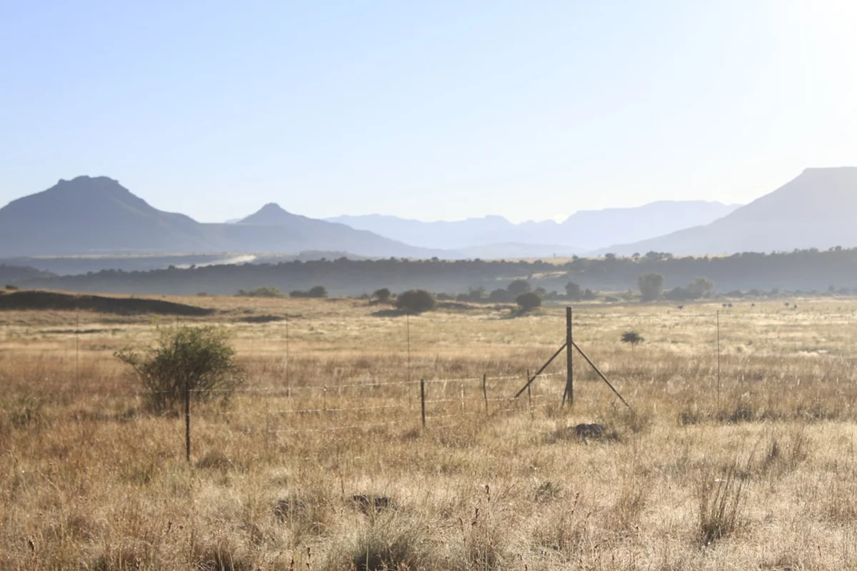
The Drakensberg Grand Traverse (DGT) is the ultimate test of endurance, navigation, and mountain craft in Southern Africa. Stretching approximately 240 kilometres along the high-altitude escarpment that forms the border between South Africa’s KwaZulu-Natal province and the mountain kingdom of Lesotho, this is not a "trail" in the traditional sense. There are no waymarkers, no groomed paths, and no signposts. Instead, the DGT is a conceptual route that requires hikers to traverse the "Barrier of Spears"—the uKhahlamba-Drakensberg—from the Sentinel Car Park in the north to the Bushman’s Nek Border Post in the south. It is a journey through a UNESCO World Heritage site, where the basalt ramparts rise over 3,000 metres above sea level, offering a landscape of staggering verticality, ancient San rock art, and a profound sense of isolation.
- Distance: Approximately 240.0 km (variable based on navigation)
- Duration: 10–14 days
- Season: April–May or September–October (avoiding peak summer storms and winter snow)
- Accommodation: Wilderness camping and natural caves (no formal huts on the escarpment)
- Highest point: Thabana Ntlenyana (3,482 m) - the highest peak in Southern Africa
- Difficulty: Very Challenging (requires advanced navigation and self-sufficiency)
- Direction: North to South (Sentinel to Bushman's Nek)
Overview
The Drakensberg Grand Traverse is widely regarded as the most demanding multi-day hike in South Africa. Unlike the well-trodden paths of Europe or North America, the DGT is a true wilderness experience. The route follows the edge of the Great Escarpment, a geological feature where the high Lesotho plateau drops precipitously into the lush valleys of KwaZulu-Natal. For the majority of the 240-kilometre journey, hikers remain above 2,800 metres, peaking at 3,482 metres atop Thabana Ntlenyana. The physical toll is immense, with a cumulative elevation gain of approximately 9,000 metres as the route weaves in and out of the various "fingers" and ridges of the escarpment.
The allure of the DGT lies in its raw, unscripted nature. To officially "complete" a Grand Traverse, hikers must pass eight specific checkpoints: the Sentinel Car Park, the top of Tugela Falls, the summit of Mont-aux-Sources, the summit of Cleft Peak, the summit of Mafadi (the highest point in South Africa), the summit of Giant’s Castle, the summit of Thabana Ntlenyana, and finally, the Bushman’s Nek Border Post. Between these points, the choice of line is entirely up to the navigator. One might choose to hug the escarpment edge for dramatic views of the "Cloud Kingdom," or move inland across the rolling, alpine grasslands of Lesotho to save time and energy.
The landscape is one of extremes. In the morning, you may find yourself walking through golden grasslands under a piercingly blue sky, watching Bearded Vultures (Lammergeier) soar on thermals. By afternoon, the "Berg" weather can transform the world into a grey void of thick mist and torrential rain. The silence of the high plateau is broken only by the whistling of wind through the basalt pinnacles and the occasional greeting from a Basotho shepherd tending his flock. This is a journey for those who seek to test their limits against a landscape that offers no concessions to the unprepared.
History and Cultural Context
The Drakensberg, or uKhahlamba ("Barrier of Spears" in isiZulu), has a human history stretching back thousands of years. The original inhabitants were the San people (Bushmen), hunter-gatherers who found refuge in the sandstone caves of the lower Berg. While the DGT stays primarily on the basalt upper escarpment, the entire region is a living museum of San culture, containing one of the highest concentrations of rock art in the world. These paintings, some dating back 3,000 years, depict the spiritual and daily lives of a people who viewed these mountains as a sacred bridge between the earthly and spirit realms.
In the 19th century, the mountains became a site of conflict and migration. The Basotho people, under King Moshoeshoe I, utilised the high plateau as a natural fortress against the expansion of the Zulu Kingdom and later, the British and Boer settlers. Today, the Lesotho side of the escarpment remains inhabited by Basotho herders who live in remote stone huts (motebos) during the summer months. Their presence is a defining characteristic of the DGT; hikers will frequently encounter these hardy shepherds, often wrapped in traditional woollen blankets, moving their sheep and angora goats across the high ridges.
The concept of the "Grand Traverse" as a hiking challenge emerged in the mid-20th century as mountaineers sought to link the various peaks of the range in a single push. It was initially a feat of endurance for members of the Mountain Club of South Africa (MCSA). Over the decades, it has evolved from a niche mountaineering objective into a legendary "bucket list" item for international trekkers. In recent years, the DGT has also become a theatre for extreme trail running, with elite athletes attempting to set "Fastest Known Times" (FKTs), some completing the entire 240-kilometre route in under 45 hours. However, for the vast majority, the DGT remains a slow, meditative, and gruelling 12-day pilgrimage through one of the world's last great mountain wildernesses.
Want more background? Read extended notes on history and cultural context → Learn more
Seasonal Highlights and Weather Reality
Weather is the single most important factor on the Drakensberg Grand Traverse. The range creates its own microclimate, and conditions can change from benign to life-threatening in a matter of minutes. Understanding the seasonal cycles is essential for a safe crossing.
Autumn (April to May): This is widely considered the "Golden Window" for the DGT. The fierce summer thunderstorms have subsided, the air is crisp and clear (providing the best photographic conditions), and the landscape is still green from the summer rains. Daytime temperatures are pleasant for hiking, though night-time temperatures on the escarpment will frequently drop below freezing. This is the most stable weather period.
Spring (September to October): The second-best window. The weather is generally dry, and the first spring flowers begin to carpet the plateau. However, this season is notorious for high winds, which can make walking along the escarpment edge dangerous. There is also a lingering risk of late-season snowstorms, which can be particularly heavy.
Summer (November to March): While the mountains are at their most lush and the water sources are plentiful, summer is the season of the "Berg Storm." Violent afternoon thunderstorms are a daily occurrence, bringing intense lightning, hail, and torrential rain. Lightning is a genuine killer on the high plateau, where hikers are often the highest point in the landscape. Navigation also becomes extremely difficult when the daily mist (the "white-out") rolls in.
Winter (June to August): Winter is the season of fire and ice. The grasslands turn a burnt orange and are often subject to controlled or wild fires. Temperatures on the escarpment regularly plummet to -10°C or -15°C. Snow is common and can linger in the gullies, requiring ice axes and crampons for certain passes. While the skies are often clear, the extreme cold and short daylight hours make this a season only for the most experienced winter mountaineers.
Recommended Itinerary
12-Day Drakensberg Grand Traverse Itinerary
Day 1: Sentinel Car Park to Tugela Falls
- Distance: 12 km
- Elevation gain: 650 m
- Time: 5–6 hours
- Start at Sentinel Car Park (2,500 m) and ascend the famous Chain Ladders
- Summit Mont-aux-Sources (3,081 m), the first official checkpoint
- Camp near the lip of Tugela Falls, the world's tallest waterfall (948 m drop)
- Spectacular views of the Amphitheatre wall at sunset
Day 2: Tugela Falls to Ifidi Cave area
- Distance: 16 km
- Elevation gain: 700 m
- Time: 7–8 hours
- Traverse the high ridges behind the Amphitheatre
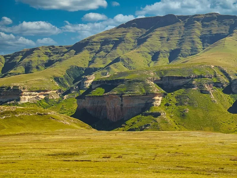
- Navigate around the Ifidi Pinnacles, some of the most dramatic rock formations in the range
- Wild camp or seek shelter in Ifidi Small Cave if available
- First real taste of the "pathless" nature of the Lesotho plateau
Day 3: Ifidi to Mnweni Cut-back
- Distance: 18 km
- Elevation gain: 800 m
- Time: 8–9 hours
- Enter the Mnweni area, often cited as the most beautiful and remote part of the Berg
- Pass the "Madonna and Her Buck" rock formation
- Navigate the complex ridges above the Mnweni Needles
- Camp near the top of Mnweni Pass, overlooking the deep, jagged valleys of the Zulu heartland
Day 4: Mnweni to Rockeries area
- Distance: 15 km
- Elevation gain: 600 m
- Time: 6–7 hours
- A shorter day to recover, focusing on the spectacular Rockeries and Orange Earth peaks
- Excellent opportunities for photography of the basalt towers
- Water collection from the upper Orange (Senqu) River tributaries
- Camp near the head of the Rockeries Pass
Day 5: Rockeries to Cathedral Peak area
- Distance: 22 km
- Elevation gain: 900 m
- Time: 9–10 hours
- A long, demanding day crossing the high alpine plains
- Pass the "Chessmen" and the "Mitre" peaks
- Navigate towards the Bell-Cathedral ridge
- Camp near the base of Cleft Peak
Day 6: Cleft Peak to Upper Injisuthi Cave
- Distance: 18 km
- Elevation gain: 850 m
- Time: 8–9 hours
- Summit Cleft Peak (3,277 m), the second major checkpoint
- Traverse the "Organ Pipes" area
- Descend towards the Injisuthi region, the highest part of the South African side
- Stay in Upper Injisuthi Cave (3,300 m), the highest cave in the Drakensberg
Day 7: Upper Injisuthi to Mafadi Summit
- Distance: 14 km
- Elevation gain: 500 m
- Time: 6–7 hours
- Summit Mafadi (3,451 m), the highest point in South Africa and a mandatory checkpoint
- The terrain here is rolling and high, often feeling like a different planet
- Pass the "Judge" and "Corner" passes
- Camp in the valley behind Mafadi to escape the wind
Day 8: Mafadi to Giant’s Castle area
- Distance: 24 km
- Elevation gain: 950 m
- Time: 10–11 hours
- One of the most gruelling days of the traverse
- Long stretches of "bundu-bashing" through thick alpine grass
- Summit Giant’s Castle (3,314 m), a mandatory checkpoint
- Camp near the Langalibalele Pass head
Day 9: Giant’s Castle to Sani Pass area
- Distance: 26 km
- Elevation gain: 800 m
- Time: 10–12 hours
- A high-mileage day across the Lesotho interior
- The terrain becomes slightly flatter but the cumulative fatigue sets in
- Cross numerous small river systems that feed the Senqu River
- Camp within striking distance of the Sani Pass road
Day 10: Sani Pass to Thabana Ntlenyana
- Distance: 15 km
- Elevation gain: 700 m
- Time: 7–8 hours
- Cross the Sani Pass road (the only road access on the entire route)
- Ascend the ridges leading to the "Beautiful Little Mountain"
- Summit Thabana Ntlenyana (3,482 m), the highest point in Southern Africa
- Camp in the high valleys south of the peak
Day 11: Thabana Ntlenyana to Thamathu Cave
- Distance: 22 km
- Elevation gain: 600 m
- Time: 8–9 hours
- The final long stretch of the Lesotho plateau
- The escarpment begins to lose its sheer verticality, becoming more rounded
- Navigate towards the southern Berg landmarks
- Camp in or near Thamathu Cave
Day 12: Thamathu Cave to Bushman’s Nek
- Distance: 18 km
- Elevation loss: 1,200 m
- Time: 6–7 hours
- The final descent off the escarpment
- Pass through the South African border controls at Bushman’s Nek
- Finish at the Bushman’s Nek Hotel/Office
- Celebration and recovery
Important Notes:
- Distances are estimates; your actual GPS track will likely be 10–20% longer due to navigation
- Water is generally available in summer/autumn but can be scarce in winter
- The route is entirely unmarked; GPS and map skills are non-negotiable
- Basotho shepherds are generally friendly but keep a respectful distance from their livestock and dogs
Planning and Bookings
Book Your Trip
Everything you need to plan your journey
Accommodation
Find places to stay near Underberg
Flights
Search flights to Underberg
Essential Preparation
The Drakensberg Grand Traverse is not a hike for beginners. It requires a high level of physical fitness, mountain competence, and mental resilience. Preparation should begin at least six months in advance. Because the route is unmarked, you must be proficient in using a GPS and reading 1:50,000 topographical maps. The "white-out" mist can occur at any time, making navigation by sight impossible.
Logistically, the DGT is a "point-to-point" hike, meaning you start and finish in different locations. Most hikers base themselves in the town of Underberg. From Underberg, you can arrange a 4x4 shuttle to the Sentinel Car Park (a 4–5 hour drive). At the end of the hike, you will finish at Bushman’s Nek, where a pre-arranged shuttle can return you to Underberg. It is essential to coordinate these transfers in advance, as mobile signal at the trailheads is unreliable.
Trail Accommodation
There is no formal accommodation on the Drakensberg escarpment. You will be entirely reliant on wilderness camping and natural caves. This is one of the few places in the world where "cave-hopping" is a legitimate form of trekking accommodation.
Caves: The Drakensberg is famous for its basalt and sandstone caves. On the escarpment, these are usually deep overhangs or small basalt chambers. Notable caves include Ifidi Small Cave, Upper Injisuthi Cave (the highest in the Berg), and Thamathu Cave. Caves offer excellent protection from wind and rain but can be damp and cold. They do not require booking, but they operate on a "first-come, first-served" basis. During peak seasons, they may already be occupied by other hikers or Basotho shepherds.
Wild Camping: You are permitted to camp anywhere on the escarpment. A high-quality, 4-season mountain tent is essential. The wind on the plateau can be ferocious, capable of snapping tent poles that are not designed for alpine conditions. Look for sheltered spots behind ridges or in valley folds. Camping on the Lesotho side is generally safer from a wind perspective but requires awareness of nearby shepherd motebos.
Facilities: There are zero facilities. No toilets, no taps, and no trash cans. You must follow strict Leave No Trace principles, including burying human waste and carrying out all litter.
Required Gear
- 4-Season Tent: Must be able to withstand winds exceeding 80 km/h and potential snow loads.
- GPS and Power Bank: Essential for navigation. Carry spare batteries or a high-capacity solar charger.
- Topographical Maps: The Slingsby "Drakensberg North" and "Drakensberg South" maps are the gold standard.
- Personal Locator Beacon (PLB): Non-negotiable. There is no mobile signal on 90% of the route. In an emergency, this is your only link to rescue services.
- Sturdy Hiking Boots: Waterproof and well broken-in. The terrain is rocky, uneven, and often boggy.
- Multi-fuel or Gas Stove: Gas performs poorly in extreme cold; a liquid fuel stove is often more reliable for winter traverses.
- Sleeping Bag: Rated for at least -10°C (comfort rating). Even in summer, the temperature can drop to freezing.
- Waterproof Shell: High-quality Gore-Tex or equivalent. The rain in the Berg is heavy and persistent.
What to Bring
- Food: 12–14 days of high-calorie, lightweight dehydrated meals. There are no resupply points on the escarpment.
- Water Treatment: While the water in the high streams is generally pure, it is shared with livestock. Use a filter or chlorine dioxide tablets.
- Sun Protection: The UV radiation at 3,000 m is intense. Bring SPF 50+ sunscreen, a wide-brimmed hat, and polarized sunglasses.
- First Aid Kit: Include blister care, broad-spectrum antibiotics, rehydration salts, and a thermal emergency blanket.
- Trowel: For burying human waste (at least 15 cm deep and 50 m from water).
- Warm Layers: Down jacket, thermal base layers (merino is best), beanie, and waterproof gloves.
- Passport: You will be weaving in and out of Lesotho. While there are no formal border posts on the escarpment, you must carry your passport and have it stamped at the start and end points.
Permits
Permits for the Drakensberg Grand Traverse are managed by Ezemvelo KZN Wildlife. Unlike many international trails, there is no "DGT Permit" per se. Instead, you pay for "Overnight Hiking" permits for the duration of your trip. These can be purchased at the Sentinel Car Park (for the northern section) or at the Ezemvelo office at Bushman’s Nek.
Mountain Register: This is the most critical part of the permit process. At the start of your hike, you must fill out the Mountain Register. You provide your intended route, the number of people in your group, and your expected return date. It is vital that you sign out of the register at Bushman’s Nek upon completion. If you do not sign out, a search and rescue operation may be initiated at your expense.
Costs: Overnight hiking fees are approximately R120 to R150 per person, per night (subject to annual increases). For a 12-day traverse, expect to pay around R1,800 per person. These fees contribute to the maintenance of the park and the funding of mountain rescue services.
Lesotho Entry: Technically, you are entering the Kingdom of Lesotho. While there are no border guards on the escarpment, you should have your passport with you. If you encounter Lesotho police or officials, they may ask to see your documents. Ensure you have officially "exited" South Africa at the police station in Underberg or at the border post if required by current regulations.
Other Activities in the Area
If you have time before or after your traverse, the KwaZulu-Natal Midlands and the Drakensberg foothills offer numerous attractions:
- Sani Pass 4x4 Tour: If you didn't get enough of the high altitude, take a guided 4x4 tour up the famous Sani Pass for a drink at the "Highest Pub in Africa."
- Rock Art Tours: Visit Main Caves at Giant’s Castle or Game Pass Shelter in the Kamberg Valley for some of the best-preserved San rock art in the world.
- Falconry Displays: The Dragon Peaks area often hosts bird of prey demonstrations, featuring indigenous eagles and vultures.
- Midlands Meander: A scenic arts and crafts route in the foothills, perfect for post-hike recovery with artisanal food, breweries, and luxury spas.
- Canopy Tours: Experience the indigenous forests of the Central Berg from a series of ziplines.
Safety and Conditions
The Drakensberg is a beautiful but unforgiving environment. Safety must be your primary concern at all times. The most significant risks are weather, navigation, and security.
Lightning: During summer, lightning is a major hazard. If a storm approaches, move away from the escarpment edge and avoid being the highest point in the landscape. Do not seek shelter in small, shallow caves, as "ground strike" current can travel through the rock. If caught in the open, crouch on your foam sleeping mat to insulate yourself from the ground.
The White-out: Thick mist can descend in minutes, reducing visibility to less than five metres. In these conditions, stay put if you are in a safe location. If you must move, rely entirely on your GPS. Many hikers have walked off the edge of the escarpment or become hopelessly lost in the Lesotho interior during a white-out.
Security: While the Basotho shepherds are generally peaceful, there have been isolated incidents of theft and harassment, particularly in the northern Berg (near the Chain Ladders) and the Sani Pass area. Always camp in groups, keep your gear inside your tent at night, and avoid camping directly on well-used shepherd paths. Being polite and offering a simple "Dumela" (hello) goes a long way in building rapport.
Rescue: Mountain Rescue in the Drakensberg is coordinated by the Mountain Club of South Africa (MCSA) and the South African Air Force. If you have an emergency and trigger your PLB, be aware that a helicopter rescue is dependent on weather. In thick mist or high winds, you may have to wait 24–48 hours for help to arrive. You must be prepared to survive on your own until then.
Side Trips and Points of Interest
While the DGT is a massive undertaking, there are several landmarks along the route that are worth the extra effort:
Tugela Falls: Don't just pass by; spend time at the lip of the falls. Watching the water plummet nearly a kilometre into the Royal Natal National Park below is a humbling experience. In winter, the falls can freeze into a massive pillar of ice.
Thabana Ntlenyana: Although it is a mandatory checkpoint, many hikers treat it as a side trip because it sits several kilometres inland from the escarpment edge. The summit offers a 360-degree view of the Lesotho highlands, a sea of rolling brown and green peaks that seems to go on forever.
The Mnweni Needles: This is arguably the most "alpine" looking part of the Berg. The jagged basalt spires are a favourite for rock climbers, but even from the hiking route, they provide a dramatic backdrop that feels more like the Himalayas than Southern Africa.
Valley of the Virgin: A hidden, lush valley near the Cathedral Peak area that offers a rare break from the windswept plateau. It is a beautiful spot for a midday break if your navigation brings you nearby.
Leave No Trace
The uKhahlamba-Drakensberg is a fragile ecosystem. The high-altitude grasslands grow slowly, and the thin soils are easily eroded. As a DGT hiker, you have a responsibility to minimise your impact.
- Waste: Carry out every single piece of litter, including "biodegradable" items like orange peels and tea bags, which take years to decompose in the cold, dry air.
- Human Waste: Use a trowel to bury waste at least 15 cm deep. Carry out your used toilet paper in a sealed bag.
- Fires: Fires are strictly prohibited on the escarpment. The grass is highly flammable, and a runaway fire can devastate thousands of hectares. Use a camping stove for all cooking.
- Water: Do not use soap directly in streams. Even biodegradable soap can harm the delicate aquatic life in the high-altitude pools. Wash at least 50 metres away from water sources.
- Rock Art: Never touch or splash water on San rock paintings. The oils from your skin and the minerals in the water cause the pigments to deteriorate rapidly.