Drakensberg Amphitheatre Hike - The Roof of South Africa
The Drakensberg Amphitheatre Hike is arguably the most iconic trekking experience in Southern Africa, offering a gateway to the "uKhahlamba" or the "Barrier of Spears." This 14-kilometre round-trip journey takes hikers to the summit of the Mont-Aux-Sources plateau, standing at approximately 2,975 metres above sea level. The centrepiece of this adventure is the Amphitheatre itself—a colossal basalt wall stretching over 5 kilometres in length and rising 1,200 metres from the Tugela Valley floor. It is a landscape of superlative scale, where the world’s second-tallest (and arguably tallest, depending on measurement criteria) waterfall, the Tugela Falls, plunges 948 metres over the precipice in a series of five spectacular cascades. This is not merely a walk; it is an ascent into a high-altitude wilderness where the air is thin, the weather is unpredictable, and the views extend across the rolling hills of KwaZulu-Natal and the rugged highlands of Lesotho.
- Distance: 14.0 km return
- Elevation Gain: 900 m
- Duration: 6–8 hours
- Difficulty: Challenging (due to altitude and technical chain ladders)
- Highest Point: Mont-Aux-Sources Plateau (~2,975 m)
- Trailhead: Sentinel Car Park (accessible via Witsieshoek Mountain Lodge)
- Key Features: The Chain Ladders, Tugela Falls, Sentinel Peak, and the Amphitheatre Wall
Overview
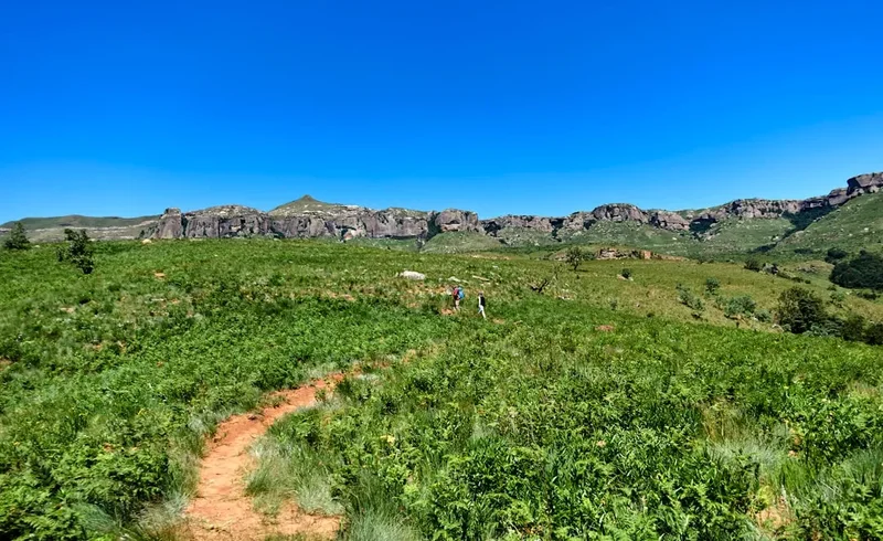
The Drakensberg Amphitheatre hike is a masterclass in geological drama. Located within the Northern Drakensberg, this route provides the most direct access to the top of the escarpment without the multi-day commitment required by most other "Berg" passes. The trail begins at the Sentinel Car Park, already perched at an impressive 2,500 metres, which means hikers start their journey in the alpine zone. The path winds beneath the towering basalt cliffs of the Sentinel Peak, a massive free-standing monolith that guards the western end of the Amphitheatre. As you traverse the base of these cliffs, the scale of the landscape becomes humbling; the verticality of the rock faces and the vastness of the valleys below create a profound sense of isolation and wonder.
The hike is famous for its two primary methods of reaching the plateau: the infamous chain ladders and the steep, rocky gully known as Beacon Buttress. The chain ladders consist of two sets of vertical steel ladders bolted directly into the cliff face, allowing hikers to bypass a sheer rock wall. For those with a head for heights, this is the highlight of the trip, offering an adrenaline-fuelled ascent with nothing but air beneath your boots. For those who prefer to keep their feet on terra firma, the gully provides a strenuous, scrambling alternative. Once atop the plateau, the terrain flattens into a vast, undulating grassland that feels like another world. Here, the Tugela River begins its journey as a modest stream before suddenly vanishing over the edge of the world at the Tugela Falls.
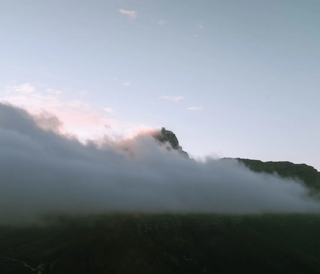
This is a high-altitude environment where conditions can change with startling rapidity. Even on a clear day, the "Berg" is known for its sudden mists—the "Cloud of the Dragon"—which can roll in and reduce visibility to a few metres within minutes. The physical challenge lies not just in the 900-metre elevation gain, but in the thin air and the technical nature of the final ascent. However, the reward is unparalleled: standing on the edge of the Amphitheatre, watching the sunrise or the clouds swirl thousands of metres below, is an experience that defines South African mountaineering. It is a place where the silence is broken only by the wind and the distant roar of falling water.
History and Cultural Context
The Drakensberg, or uKhahlamba in isiZulu, has a human history stretching back thousands of years. The original inhabitants were the San people (Bushmen), who lived in the caves and rock shelters of the lower valleys. While the Amphitheatre plateau itself was too harsh for permanent habitation, the surrounding area is a treasure trove of San rock art, with thousands of paintings depicting hunts, rituals, and the spiritual connection between the people and the eland. To the San, these mountains were a sacred realm, a bridge between the physical and spiritual worlds. The name "uKhahlamba" perfectly captures the visual impact of the range—a jagged, formidable barrier of spears protecting the interior.
European exploration of the Amphitheatre began in earnest in the 19th century. The name "Mont-Aux-Sources" (Mountain of Sources) was given by French missionaries Arbousset and Daumas in 1836, who recognised the plateau as the source of several major rivers, including the Tugela, the Vaal, and the Orange (Senqu). The Tugela flows east into the Indian Ocean, while the Orange flows west across the entire continent to the Atlantic. This hydrological significance made the area a focal point for early surveyors and adventurers. The Sentinel Peak, the most prominent feature of the hike, was first climbed in 1910 by W.J. Wybergh, marking the beginning of the Drakensberg's reputation as a premier climbing destination.
In 1916, the Royal Natal National Park was established, encompassing the Amphitheatre and the Tugela Valley. The park received its "Royal" prefix following the visit of the British Royal Family in 1947, who stayed at the hostel (now the Royal Natal National Park Hotel ruins) and were captivated by the view of the Amphitheatre. Today, the area is part of the Maloti-Drakensberg Park, a UNESCO World Heritage Site recognised for both its exceptional natural beauty and its wealth of San rock art. The hike to the top of the Amphitheatre remains a pilgrimage for those seeking to understand the geological and cultural heart of South Africa.
Want more background? Read extended notes on history and cultural context → Learn more
Seasonal Highlights and Weather Reality
The Drakensberg is a land of climatic extremes, and choosing the right time for your hike is critical for both safety and enjoyment. The weather is dictated by the high altitude and the escarpment's role as a weather maker, catching moisture from the Indian Ocean and forcing it upwards.
Autumn (March to May): This is widely considered the "Golden Season" for hiking the Amphitheatre. The summer rains have subsided, leaving the landscape lush and vibrant green. The air is crisp and clear, providing the best visibility for the expansive views from the plateau. Temperatures are mild during the day, though nights begin to get cold. This is the most stable weather window, with a lower risk of the violent thunderstorms that plague the summer months.
Spring (September to November): Another excellent window, spring brings the blooming of alpine wildflowers and the return of migratory birds. The weather is generally pleasant, though it can be windier than autumn. Early spring may still see the occasional late-season snowstorm, and by November, the afternoon thunderstorms begin to return. The Tugela Falls are often at their most photogenic during this time as the first rains replenish the river.
Summer (December to February): Summer in the Berg is spectacular but challenging. The mountains are a deep, emerald green, and the Tugela Falls are in full flow. However, this is also the season of the "Berg Storm." Afternoon thunderstorms are almost a daily occurrence, bringing intense rain, hail, and dangerous lightning. Hikers must start very early (dawn) to ensure they are off the plateau and away from the chain ladders before the storms break, usually around 2:00 PM. Heat and humidity in the lower sections can also be taxing.
Winter (June to August): Winter offers a completely different experience. The landscape turns a burnt orange and gold, and the air is incredibly dry and still. Snow is common on the plateau, sometimes covering the chain ladders in ice and making the ascent extremely hazardous. While the days are often sunny and clear, temperatures on the summit can drop well below -10°C at night. The Tugela Falls may freeze into a giant pillar of ice—a rare and beautiful sight. Winter hiking requires specialist gear and experience in sub-zero conditions.
Recommended Itinerary
Standard Day Hike Itinerary
Early Morning: Arrival and Registration
- Time: 07:00 – 07:30
- Arrive at the Sentinel Car Park (2,500 m).
- Register your details in the mountain rescue register—this is a mandatory safety requirement.
- Pay the hiking fees (if not already paid at Witsieshoek).
- Final gear check: ensure you have sufficient water, warm layers, and a waterproof jacket.
- The air is already thin here; take a few minutes to adjust your breathing before starting.
Morning: The Sentinel Traverse
- Time: 07:30 – 09:30
- Distance: ~4 km
- The trail begins on a well-maintained path that contours around the base of the Sentinel Peak.
- Enjoy the "Zig-zags," a series of switchbacks that gain elevation steadily.
- Pass beneath the massive basalt cliffs; look out for Bearded Vultures (Lammergeiers) soaring on the thermals.
- The path can be narrow in places with significant drop-offs to the right—watch your footing.
- Reach the junction for the Chain Ladders and the Beacon Buttress Gully.
Mid-Morning: The Ascent (Chain Ladders or Gully)
- Time: 09:30 – 10:30
- Option A: The Chain Ladders. Climb two sections of vertical steel ladders. The first section is approximately 20 metres, followed by a short ledge and a second 15-metre section. There are two sets of ladders to allow for two-way traffic.
- Option B: Beacon Buttress Gully. A steep, rocky scramble that requires no technical gear but demands physical stamina and careful foot placement on loose scree.
- Both routes converge at the top of the escarpment (approx. 2,950 m).
Midday: The Plateau and Tugela Falls
- Time: 10:30 – 12:30
- Distance: ~3 km (on the plateau)
- Once on top, the terrain is relatively flat but can be marshy.
- Follow the trail (or the riverbed) east towards the edge of the Amphitheatre.
- Arrive at the lip of the Tugela Falls. This is the perfect spot for a long lunch.
- Explore the edge of the Amphitheatre wall, which stretches for kilometres in either direction.
- On a clear day, you can see the Devil's Tooth, the Eastern Buttress, and far into the valleys of Royal Natal National Park.
Afternoon: The Descent
- Time: 12:30 – 15:30
- Begin the trek back across the plateau towards the ladders or gully.
- Descending the chain ladders can be more intimidating than climbing them—take your time and maintain three points of contact.
- Retrace your steps along the Sentinel traverse. The afternoon light often illuminates the cliffs in brilliant oranges and reds.
- Arrive back at the Sentinel Car Park.
- Sign out of the mountain register (crucial so rangers don't initiate a search).
Important Notes:
- Total walking time is usually 6–7 hours, but allow 8 hours for photography and rest.
- If mist rolls in on the plateau, navigation becomes extremely difficult. Use a GPS or compass to find the top of the ladders.
- The chain ladders are not recommended for those with severe vertigo.
- Always check the wind speed; high winds can make the ladders dangerous.
Planning and Bookings
Book Your Trip
Everything you need to plan your journey
Accommodation
Find places to stay near Bergville
Flights
Search flights to Bergville
Essential Preparation
The Drakensberg Amphitheatre hike requires a moderate to high level of fitness. While the distance is not extreme, the altitude and the technical nature of the chain ladders add a layer of difficulty. Hikers should be comfortable with steep ascents and have no debilitating fear of heights. Preparation should include cardiovascular training and some experience with rocky terrain.
Logistically, the hike is best accessed from the town of Bergville or the nearby Witsieshoek Mountain Lodge. Witsieshoek is the highest lodge in the Northern Drakensberg and provides the most convenient base, as it is located at the end of the road leading to the Sentinel Car Park. The road from Witsieshoek to the car park is approximately 7 kilometres of rough gravel and rock; while high-clearance vehicles are recommended, the lodge provides a shuttle service for those in standard cars. It is essential to book this shuttle in advance, especially during peak periods.
Trail Accommodation
As this is primarily a day hike, most visitors stay in the surrounding lodges or campsites. However, overnighting on the plateau is a popular option for experienced trekkers.
Nearby Lodges:
- Witsieshoek Mountain Lodge: Offers a range of accommodation from luxury chalets to hiker cabins. It is the closest accommodation to the trailhead and manages the Sentinel Car Park access.
- Royal Natal National Park (Thendele Camp): Located in the valley below the Amphitheatre. It offers spectacular views of the wall from below but requires a drive of about 90 minutes to reach the Sentinel trailhead.
- Mahai and Rugged Glen Campsites: Excellent camping facilities within Royal Natal National Park for those on a budget.
On-Trail Accommodation (Overnighting):
- There are no huts or formal shelters on the Mont-Aux-Sources plateau.
- Wild camping is permitted on the plateau. You must bring a high-quality, four-season mountain tent capable of withstanding high winds.
- Caves: There are several small rock shelters (caves) on the plateau, such as Crow's Nest, but these offer minimal protection and can be difficult to find in the mist.
- Note: If camping on the plateau, you must be self-sufficient with all water treatment, cooking, and waste management gear.
Required Gear
- Hiking Boots: Sturdy, waterproof boots with good ankle support are essential for the rocky terrain and the chain ladders.
- Waterproof Jacket: A high-quality hardshell (Gore-Tex or similar) is non-negotiable. The Berg is famous for sudden, heavy rain.
- Insulating Layers: A fleece or down jacket, even in summer. Temperatures on the plateau are significantly lower than in the valleys.
- Daypack: A 20–30L pack with a rain cover.
- Navigation: A GPS device with offline maps, a compass, and a physical map of the Northern Drakensberg.
- Sun Protection: High-SPF sunscreen, a wide-brimmed hat, and UV-rated sunglasses. The sun at 3,000 metres is exceptionally intense.
- Headlamp: With spare batteries, in case the hike takes longer than expected.
- Whistle: For emergency signalling in the mist.
What to Bring
- Water: At least 2–3 litres per person. While there are streams on the plateau, they should be treated due to the presence of livestock (Basotho shepherds).
- Water Treatment: Purification tablets or a lightweight filter (e.g., Sawyer Squeeze).
- High-Energy Food: Pack a substantial lunch plus snacks like nuts, dried fruit, and energy bars. You will burn significant calories at altitude.
- First Aid Kit: Including blister plasters, antiseptic wipes, bandages, and any personal medications.
- Emergency Blanket: A lightweight space blanket for every hiker.
- Gloves and Beanie: Essential for the cold wind on the plateau, even in shoulder seasons.
- Cash/Cards: For the hiking permit fees at the car park and the Witsieshoek shuttle.
- Power Bank: To keep your phone/GPS charged, as cold temperatures drain batteries quickly.
Permits
Permits for the Drakensberg Amphitheatre hike are relatively straightforward to obtain compared to many international trails, but they are mandatory for safety and conservation funding.
Permit Process:
- Permits are issued at the Sentinel Car Park office or can be pre-arranged through Witsieshoek Mountain Lodge.
- You do not need to book months in advance; permits are generally available on the day for day hikers.
- Mountain Register: Every hiker MUST sign the mountain register at the car park before starting and upon return. This is the primary tool used by Mountain Rescue to identify missing persons.
Costs (Approximate):
- Hiking Fee: Approximately R110–R150 per person for a day hike.
- Overnight Fee: If you plan to camp on the plateau, an additional overnight fee (approx. R100 per night) is required.
- Vehicle Access Fee: There is a fee for the road leading to the car park, usually managed by Witsieshoek.
- Note: Prices are subject to change and are often higher for international visitors than for South African residents.
Group Size and Regulations:
- While there is no strict limit on the number of day hikers, large groups (10+) should notify the park authorities in advance.
- No fires are permitted anywhere on the trail or the plateau.
- No pets are allowed in the Maloti-Drakensberg Park.
- Drones are strictly prohibited without a specific commercial permit, which is rarely granted for recreational use.
Other Activities in the Area
The Northern Drakensberg is a hub for outdoor enthusiasts. If you have extra time, consider these activities:
- Tugela Gorge Walk: A spectacular 14-kilometre (return) hike that stays in the valley, leading you to the base of the Amphitheatre. It involves river crossings and a scramble through a narrow tunnel—a great alternative if the weather is too bad for the summit.
- The Crack and Mudslide: A challenging loop hike from Mahai campsite that involves climbing through a narrow rock cleft and descending a steep, forested slope.
- Rock Art Tours: Visit the Sigubudu Shelter or other sites with a registered guide to see ancient San paintings.
- Horse Riding: Many lodges, including Rugged Glen, offer guided outrides through the lower slopes of the mountains.
- Bird Watching: The area is a haven for raptors. Keep an eye out for the Cape Vulture and the rare Bearded Vulture.
- Fly Fishing: The local rivers and dams are well-stocked with trout, though permits and seasonal restrictions apply.
Safety and Conditions
Weather Hazards: The greatest danger in the Drakensberg is the weather. Lightning is a significant threat during summer; if you hear thunder or see dark clouds building, descend immediately. Do not stay on the plateau. Mist can disorient even experienced hikers. If you lose the trail in the mist, stay put or use your GPS to retrace your steps exactly. Hypothermia is a risk year-round if you get wet and the wind picks up.
The Chain Ladders: These are maintained by the local authorities, but you should always inspect them before climbing. Check for loose bolts or damaged rungs. Only one person should be on a ladder section at a time. If you are uncomfortable, use the Beacon Buttress Gully instead. In high winds or icy conditions, the ladders should be avoided entirely.
Security: While the Amphitheatre is generally safe, there have been occasional reports of petty theft from tents on the plateau by Basotho shepherds. If camping, it is best to camp in a group and keep your valuables inside your sleeping bag. Be polite but firm with shepherds; do not give away food or money, as this encourages aggressive begging.
Emergency Contacts:
- Mountain Club of South Africa (Search and Rescue): 0800 005 133
- Witsieshoek Mountain Lodge: +27 (0)58 713 6361
- Royal Natal National Park Office: +27 (0)36 438 6310
Side Trips and Points of Interest
Tugela Falls: The primary destination on the plateau. Ensure you walk far enough along the edge to see the water actually leaving the lip. In winter, look for the "ice candles" where the spray freezes on the cliffs.
Sentinel Peak: While the peak itself requires technical rock climbing (Grade 15/5.7), the base offers incredible photographic opportunities. The "Sentinel Caves" near the base are a good spot for a quick break out of the wind.
Beacon Buttress: The highest point in the immediate vicinity of the ladders. A short scramble to the top of the buttress provides a 360-degree view that includes the Maloti mountains of Lesotho to the west.
Mont-Aux-Sources Summit: About a 3-kilometre walk from the top of the ladders, this is the actual peak (3,048 m). It is marked by a large stone cairn and offers a sense of completion for those who want to stand on the very top of the massif.
Leave No Trace
The Drakensberg is a fragile high-altitude ecosystem. The thin soils and harsh climate mean that vegetation takes a long time to recover from damage. As a UNESCO World Heritage site, it is our collective responsibility to preserve it.
Core Principles:
- Pack it in, Pack it out: This includes all organic waste like orange peels and apple cores, which do not decompose quickly at this altitude and can be harmful to local wildlife.
- Stay on the Path: Avoid creating "social trails," especially on the zig-zags, as this leads to severe erosion during heavy rains.
- Respect the Water: Do not use soap or detergents in the streams on the plateau. Wash yourself and your dishes at least 30 metres away from water sources.
- Human Waste: If you must go, dig a "cathole" at least 15–20 cm deep and at least 50 metres from any water source. Pack out your toilet paper in a sealed bag.
- Leave What You Find: Do not pick wildflowers or remove rocks. Never touch or deface San rock art.