
Tre Cime di Lavaredo - The Crown of the Dolomites
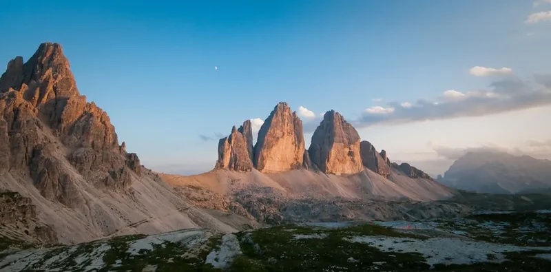
The Tre Cime di Lavaredo (Drei Zinnen in German) represents the quintessential image of the Italian Dolomites. Located within the Sesto Dolomites Nature Park, these three distinctive battlement-like peaks—Cima Piccola (Little Peak), Cima Grande (Big Peak), and Cima Ovest (Western Peak)—rise abruptly from the surrounding scree slopes like a natural fortress of pale rock. The 9.5 km loop circuit is widely considered one of Europe's most spectacular day walks, offering a high-reward-to-effort ratio that makes the sublime beauty of the high Alps accessible to moderate hikers. This journey takes you through a landscape of stark geological contrasts, from lush alpine meadows filled with wildflowers to the jagged, war-torn limestone spires that have witnessed both the birth of modern mountaineering and the tragedies of the First World War. Walking here is not merely a physical exercise; it is a pilgrimage to a UNESCO World Heritage site where the verticality of the terrain defies belief and the shifting light of the South Tyrol transforms the rock from pale grey to burning orange in a matter of minutes.
- Distance: 9.5 km loop
- Duration: 3–4 hours (walking time)
- Elevation Gain: 400 m
- Difficulty: Moderate
- Highest Point: 2,454 m (Forcella Lavaredo)
- Best Time: June to September
- Closest City: Cortina d'Ampezzo
- Trailhead: Rifugio Auronzo
Overview
The Tre Cime di Lavaredo circuit is a masterclass in alpine scenery, providing a 360-degree perspective of the most famous trio of peaks in the world. The trail begins at the southern base of the massif at Rifugio Auronzo, situated at an altitude of 2,320 metres. From here, the path follows a well-maintained gravel track that skirts the southern faces of the peaks, offering immediate views of the Cadini di Misurina range to the south—a jagged collection of spires that look like something out of a gothic fantasy. As you progress, the trail transitions from the relatively flat southern traverse to a gradual ascent toward the Forcella Lavaredo, the highest point of the hike. It is at this saddle that the true scale of the Tre Cime is revealed; the sheer north faces, which drop vertically for hundreds of metres, come into view, creating a silhouette that is instantly recognisable to climbers and nature lovers globally.
The landscape is dominated by "Dolomite," a carbonate rock that gives these mountains their unique pale hue and crumbly texture. Unlike the granite of the central Alps, the Dolomites are characterised by their verticality and the vast aprons of scree (talus) that collect at their feet. The loop continues toward Rifugio Locatelli (Dreizinnenhütte), which serves as the primary vantage point for the iconic "postcard" view of the three peaks standing in perfect alignment. The return leg of the journey takes hikers through the Grava Longa plateau, passing small alpine tarns and the Malga Langalm, where the terrain becomes softer and more verdant. This section provides a stark contrast to the rocky austerity of the north faces, with marmots frequently seen scurrying among the boulders and alpine choughs circling the thermals above. The circuit is designed to be walked in a counter-clockwise direction, ensuring that the most dramatic views are saved for the middle and end of the trek, providing a constant sense of discovery as each new angle of the peaks is revealed.
History and Cultural Context
The history of the Tre Cime di Lavaredo is as dramatic as its topography. For centuries, these peaks formed a natural boundary between different cultures and empires. The first recorded ascent of the Cima Grande was achieved in 1869 by the legendary mountaineer Paul Grohmann, accompanied by local guides Franz Innerkofler and Peter Salcher. This feat marked the beginning of the "Golden Age" of mountaineering in the Dolomites, turning the Tre Cime into a laboratory for technical climbing. The Cima Ovest was conquered in 1879, and the technically difficult Cima Piccola followed in 1881. These early explorers had to contend with primitive equipment and the unpredictable weather of the high Alps, laying the groundwork for the thousands of climbers who now test themselves on the peaks' famous "Direttissima" routes.
However, the mountains also hold a darker history. During the First World War (1915–1918), the Tre Cime became a frontline in the conflict between the Kingdom of Italy and the Austro-Hungarian Empire. The "Great War in the Mountains" saw soldiers stationed at altitudes exceeding 2,500 metres, enduring brutal winters and constant shelling. The landscape is still scarred by this conflict; hikers will notice numerous tunnels, trenches, and fortified caves carved directly into the rock, particularly around Monte Paterno and the base of the Tre Cime. These "gallerie" were used to move troops and supplies out of the line of sight of enemy snipers. Today, many of these tunnels have been incorporated into Via Ferrata routes (protected climbing paths), serving as a somber reminder of the thousands of young men who lived and died in these heights. The region's dual identity is also reflected in its nomenclature; every peak, hut, and pass has both an Italian and a German name, a legacy of the area's transition from Austrian Tyrol to Italian territory after 1918.
In 2009, the Dolomites were inscribed as a UNESCO World Heritage site, recognised for their exceptional natural beauty and their scientific importance to the history of geology. The Tre Cime di Lavaredo is the crown jewel of this designation. The cultural heritage of the Ladin people, the indigenous inhabitants of the Dolomites, also permeates the region. Their unique language and traditions, which predate both Italian and German influence in the area, are still celebrated in the surrounding valleys, adding a rich layer of human history to the geological wonder of the peaks.
Want more background? Read extended notes on history and cultural context → Learn more
Seasonal Highlights and Weather Reality
The hiking season for the Tre Cime di Lavaredo is relatively short, dictated by the opening of the toll road from Misurina and the presence of snow on the high passes. Generally, the trail is accessible from late June to late September. Outside of this window, the route requires specialized winter equipment and advanced navigation skills, as the trail markers are often buried under several metres of snow.
Summer (July and August): This is the peak season. The weather is generally stable, with daytime temperatures ranging from 10°C to 20°C. However, the Dolomites are notorious for afternoon thunderstorms. A clear morning can rapidly transform into a violent electrical storm by 2:00 PM. Hikers should aim for early starts to ensure they are off the exposed ridges before the clouds build up. This is also the time when the alpine flora is at its most vibrant; look for the rare Edelweiss, the bright yellow Alpine Poppy, and various species of Gentian in the meadows near Malga Langalm.
Autumn (September): Many experienced hikers consider September the best month to visit. The summer crowds begin to thin, and the air becomes exceptionally clear, providing the best visibility for photography. The "Enrosadira" phenomenon—where the limestone peaks turn a deep crimson or violet at sunset—is particularly spectacular in the autumn light. Temperatures are cooler, often dropping toward freezing at night, so extra layers are essential. The toll road usually remains open until the first significant snowfall, which typically occurs in early to mid-October.
Spring (May to June): This is a transitional period. While the valleys may be warm, the Tre Cime circuit often remains under heavy snow. The toll road usually opens in late May or early June, but hikers should expect to encounter snow patches on the northern side of the loop (between Rifugio Locatelli and Malga Langalm) well into July. Sturdy, waterproof boots and trekking poles are highly recommended during this time.
Recommended Itinerary
Tre Cime di Lavaredo Loop (Counter-Clockwise)
Early Morning: Arrival and Southern Traverse
- Start: Rifugio Auronzo (2,320 m)
- Distance: 1.5 km to Rifugio Lavaredo
- Time: 30–45 minutes
- Begin at the large parking area at Rifugio Auronzo. Follow Path 101, a wide, flat gravel road heading east.
- Pass the small Cappella degli Alpini (Alpine Chapel) on your right, dedicated to those who fell in the mountains.
- Enjoy the views of the Cadini di Misurina spires to the south and the massive southern walls of the Tre Cime to your left.
- Arrive at Rifugio Lavaredo (2,344 m), a perfect spot for a quick espresso before the first ascent.
Mid-Morning: The Ascent to Forcella Lavaredo
- Distance: 1 km
- Elevation Gain: 110 m
- Time: 20–30 minutes
- From Rifugio Lavaredo, you have two choices: the wide road that zigzags up, or a steeper, direct footpath. Both lead to the Forcella Lavaredo (2,454 m).
- This is the highest point of the trek and the first moment you see the iconic north faces of the peaks.
- The view from the saddle is breathtaking, looking across to Monte Paterno and the distant peaks of the Austrian Alps.
- Pause here to appreciate the verticality of the Cima Grande, which rises nearly 500 metres straight up from the scree.
Midday: The Traverse to Rifugio Locatelli
- Distance: 2.5 km
- Time: 45–60 minutes
- Continue on Path 101, which traverses the scree slopes beneath Monte Paterno.
- The trail is relatively level but offers constantly changing perspectives of the Tre Cime.
- Arrive at Rifugio Locatelli (Dreizinnenhütte) at 2,405 m. This is the most famous viewpoint in the Dolomites.
- The hut sits on a ridge overlooking two small alpine lakes (Laghi dei Piani) and provides the classic view of the three peaks in alignment.
- This is the ideal location for lunch. The hut serves traditional South Tyrolean fare like Canederli (bread dumplings) and Apple Strudel.
Afternoon: The Return via Malga Langalm
- Distance: 4.5 km
- Elevation: 200 m descent, then 150 m ascent
- Time: 1.5–2 hours
- From Rifugio Locatelli, descend Path 102/105 into the valley floor (Rienza Valley).
- The trail drops steeply before climbing back up toward the Grava Longa plateau.
- Pass the Malga Langalm (2,283 m), a smaller, rustic hut known for its local cheese and tranquil setting near three tiny tarns.
- The final stretch of Path 105 skirts the western side of the Cima Ovest, offering a close-up look at the massive overhangs that are legendary in the climbing world.
- The trail rounds the corner and returns to the Rifugio Auronzo parking area, completing the loop.
Important Notes:
- The loop can be walked in either direction, but counter-clockwise is recommended for the best reveal of the peaks.
- The trail is well-marked with red and white painted signs and the number 101/105.
- Expect significant crowds between 10:00 AM and 3:00 PM during August.
- There is no shade on the trail; sun protection is vital.
- Water is available at the Rifugios, but there are few natural springs along the path.
Planning and Bookings
Book Your Trip
Everything you need to plan your journey
Accommodation
Find places to stay near Cortina d'Ampezzo
Flights
Search flights to Cortina d'Ampezzo
Essential Preparation
While the Tre Cime di Lavaredo is a day walk, its high-altitude environment requires careful preparation. The most critical factor is timing. Because of its fame, the trail can become extremely congested. To experience the peaks in relative peace, aim to arrive at the Rifugio Auronzo trailhead by 7:30 AM. The toll road often sees long queues by mid-morning, and the parking lot can fill up completely by 10:00 AM during peak season.
Cortina d'Ampezzo is the most popular base for this hike. It is a world-class mountain town with extensive facilities, including gear shops, supermarkets, and a wide range of accommodation. Alternatively, the town of Dobbiaco (Toblach) to the north offers a more relaxed, Germanic atmosphere and excellent public transport links to the trailhead via the Dolomiti Bus service. Fitness requirements are moderate; anyone capable of walking 10 kilometres on uneven terrain with some uphill sections will find the trail manageable. However, the altitude (over 2,300 metres) can make breathing more difficult for those arriving directly from sea level.
Trail Accommodation
As this is a day hike, most visitors do not require overnight accommodation on the trail itself. However, staying at one of the mountain huts (Rifugios) is a magnificent way to experience sunrise and sunset on the peaks without the daytime crowds.
Rifugio Auronzo: Located at the trailhead. It is the most accessible and functions more like a high-altitude hotel. It offers private rooms and dormitories. It is ideal for those wanting to start their hike at first light.
Rifugio Lavaredo: A smaller, more traditional hut located about 30 minutes into the hike. It offers a more intimate atmosphere and is situated right at the base of the peaks.
Rifugio Locatelli (Dreizinnenhütte): The most iconic hut on the circuit. It is extremely popular and usually requires booking months in advance for overnight stays. It offers dormitory-style "matratzenlager" (mattress rooms). Facilities are basic: shared bathrooms, limited water for showers (often coin-operated), and no WiFi. Half-board (dinner and breakfast) is the standard booking option.
Booking Requirements: Rifugios in the Dolomites typically open for bookings in early spring. Most require an email request or use an online booking portal. During the peak months of July and August, weekend spots are often taken six months in advance. Costs for a dormitory bed with half-board typically range from €70 to €90 per person.
Required Gear
- Footwear: Sturdy hiking boots with good ankle support and a lugged sole (Vibram or similar). The terrain is rocky and can be slippery when wet.
- Clothing: A layering system is essential. Even in summer, temperatures can drop rapidly. Bring a moisture-wicking base layer, a fleece or down mid-layer, and a high-quality waterproof shell jacket.
- Sun Protection: The UV radiation at 2,400 metres is intense. Bring a wide-brimmed hat, high-SPF sunscreen, and category 3 or 4 sunglasses.
- Navigation: The trail is well-marked, but a physical map (Tabacco Map 010: Sesto Dolomites) or an offline GPS app (like Komoot or AllTrails) is recommended for safety in case of fog.
- Trekking Poles: Highly recommended for the descent from Rifugio Locatelli to the valley floor to save your knees.
What to Bring
- Water: At least 2 litres per person. While you can refill at Rifugios, the water is often hauled up or filtered from snowmelt, so carrying your own is more reliable.
- Food: High-energy snacks (nuts, dried fruit, chocolate). While the Rifugios serve excellent meals, having your own supplies allows for flexibility.
- Cash: Many Rifugios prefer cash for small purchases like coffee or snacks, as satellite card terminals can be temperamental in the mountains. You will also need cash or a card for the €30 toll road fee.
- First Aid: A basic kit containing blister plasters (Compeed), antiseptic wipes, and ibuprofen.
- Headlamp: Even if you plan to be back by afternoon, always carry a light in case of unexpected delays.
Permits
No traditional hiking permits are required to walk the Tre Cime di Lavaredo circuit. However, access to the trailhead is regulated by a toll road (the Misurina-Auronzo road), which functions as a de facto access permit. The road is managed by the municipality of Auronzo di Cadore.
Toll Road Fees (2024/2025 pricing):
- Private Cars: €30.00
- Motorcycles: €20.00
- Caravans/Motorhomes: €45.00 (Note: Overnight parking for motorhomes is permitted for an additional fee, but there are no hookups).
- Buses (up to 30 seats): €60.00
- Buses (over 30 seats): €120.00
The toll gate is located just above Lake Antorno. During the height of summer, the road is closed once the parking capacity at Rifugio Auronzo (approx. 700 spaces) is reached. This often happens as early as 9:00 AM. Once closed, the road only re-opens as cars descend. To avoid the toll and the parking stress, many hikers use the "Dolomiti Bus" shuttle service from Misurina or Dobbiaco, which costs approximately €15.00 for a return ticket. If you choose to walk up from Misurina to avoid the toll, be prepared for an additional 800 metres of elevation gain and 2 hours of walking each way.
Other Activities in the Area
The area surrounding the Tre Cime is a hub for outdoor adventure and alpine culture:
- Via Ferrata Innerkofler: A classic "iron path" that leads through WWI tunnels to the summit of Monte Paterno. It requires a harness, helmet, and lanyard set, offering incredible views of the Tre Cime north faces.
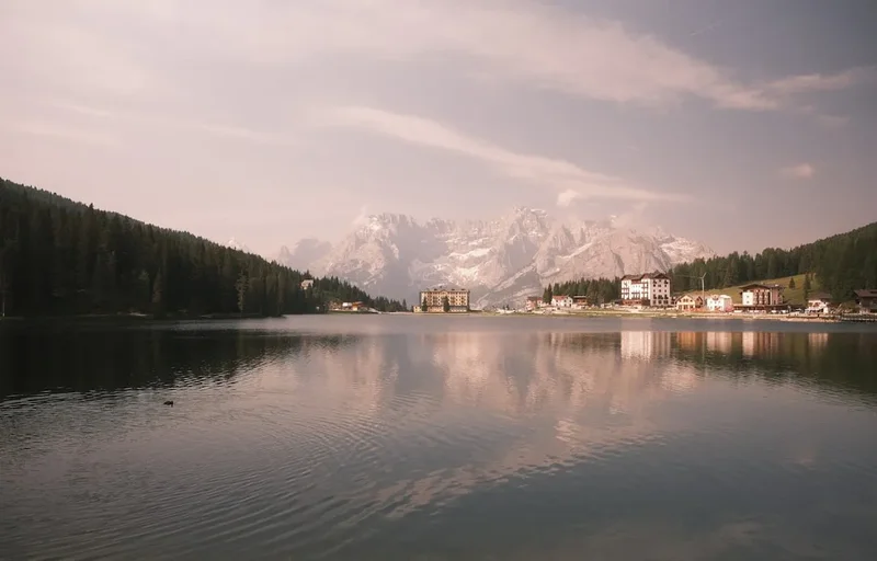
- Lake Misurina: Known as the "Pearl of the Dolomites," this stunning lake is located just below the toll road. It is famous for its microclimate, which is beneficial for respiratory health, and the grand Grand Hotel Misurina on its shores.
- Cadini di Misurina Viewpoint: A short 30-minute walk south from Rifugio Auronzo leads to one of the most dramatic viewpoints in the Alps, looking over the jagged spires of the Cadini group.
- Lago di Braies (Pragser Wildsee): Located about 45 minutes away by car, this is perhaps the most famous lake in Italy, known for its emerald waters and the towering Croda del Becco.
- Cortina d'Ampezzo: Explore the chic Corso Italia, visit the Mario Rimoldi Modern Art Museum, or take the Freccia nel Cielo cable car to the summit of Tofana di Mezzo (3,244 m).
Safety and Conditions
Weather Awareness: The most significant danger on the Tre Cime circuit is the weather. Lightning is a lethal threat on these exposed ridges. If you see dark clouds gathering or hear distant thunder, descend immediately. Do not seek shelter under isolated trees or near metal cables (like those on Via Ferratas). The temperature can drop from 20°C to 5°C in minutes during a hail storm.
Terrain: While the main path (101) is wide, other sections of the loop involve narrow trails with steep drop-offs. The limestone scree can be very unstable; stay on the marked paths to avoid causing rockfalls that could injure hikers below you. If you choose to explore the WWI tunnels, a helmet and a powerful headlamp are essential, as the floors can be uneven and slippery.
Altitude: At 2,450 metres, mild altitude sickness (headache, nausea) is possible for some. Stay hydrated and move at a steady, sustainable pace. If symptoms persist, descend to a lower altitude.
Emergency Contacts: The European emergency number is 112. Mountain Rescue (Soccorso Alpino) is highly professional in this region, but helicopter evacuations are expensive; ensure your travel insurance specifically covers "mountain search and rescue."
Side Trips and Points of Interest
The WWI Tunnels of Monte Paterno: Directly opposite the Tre Cime, Monte Paterno is honeycombed with tunnels. Even without full climbing gear, hikers can explore the entrance of the "Galleria del Monte Paterno" near Forcella Lavaredo. These tunnels were hand-blasted by soldiers and offer a chilling perspective on the conditions of the Great War. A torch is mandatory.
The Lakes of the Piani: Located just behind Rifugio Locatelli, these two sapphire-blue lakes (Laghi dei Piani) provide a peaceful escape from the main trail. The reflection of the surrounding peaks in the still water is a favourite for photographers, especially in the early morning light.
Cima Grande First Ascent Plaque: Near the base of the Cima Grande, look for small commemorative plaques dedicated to the pioneers of Dolomite climbing. The history of the "Six Great North Faces of the Alps" (of which Cima Grande is one) is written in the rock here.
The "Frankfurter Würstel": A distinctive rock pinnacle near the Malga Langalm that resembles a giant sausage. It is a popular landmark and a testament to the whimsical shapes created by Dolomite erosion.
Leave No Trace
The Tre Cime di Lavaredo is a fragile alpine ecosystem under immense pressure from its own popularity. With over 2,000 visitors a day in peak season, the cumulative impact can be devastating. Adhering to Leave No Trace principles is not optional; it is a requirement for the preservation of this UNESCO site.
Key Responsibilities:
- Stay on the Path: The alpine tundra is extremely slow to recover. A single footstep off-trail can destroy plants that have taken years to grow. Do not take shortcuts on switchbacks, as this causes severe erosion.
- Waste Management: There are no rubbish bins along the trail. Pack out every single item, including organic waste like apple cores or banana skins, which do not decompose quickly at this altitude and can harm local wildlife.
- Wildlife: Do not feed the marmots or alpine choughs. Human food disrupts their natural diet and makes them dependent on hikers.
- Drones: The use of drones is strictly prohibited in the Sesto Dolomites Nature Park to protect the peace of other hikers and the nesting sites of birds of prey like the Golden Eagle.
- Wild Camping: Camping is strictly forbidden throughout the park. Use the designated Rifugios if you wish to stay overnight.