Italy — Cortina d'Ampezzo
Traverse Italy's Dolomites on the Alta Via 4, an 85km high-altitude route from San Candido to Pieve di Cadore. This challenging, 6-8 day trek, also known as the "Alta Via di Grohmann," winds through rugged alpine terrain, past dramatic peaks and glacial valleys. Expect demanding ascents, exposed ridges, and breathtaking panoramas on this historic mountaineering path.
Distance: 85.0 km
Elevation Gain: 6300 m
Difficulty: Challenging
Duration: 6-8 days
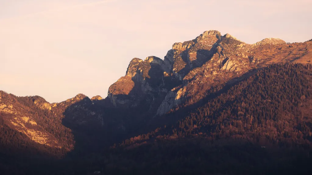
The Dolomites Alta Via 4, also known as the "Alta Via di Grohmann," is a spectacular high-altitude traverse through the heart of the Italian Dolomites. Stretching approximately 85 kilometres from the alpine town of San Candido (Innichen) in the north to Pieve di Cadore in the south, this route is named in honour of Paul Grohmann, the legendary Austrian mountaineer who completed many of the first ascents in these peaks during the 19th century. Unlike the more crowded Alta Via 1, the Fourth Way offers a more rugged, technical, and solitary experience, crossing some of the most iconic massifs in the UNESCO World Heritage site, including the Sexten Dolomites, the Cadini di Misurina, the Sorapiss group, and the mighty Antelao.
This is a journey of dramatic contrasts. Walkers transition from the lush, green valleys of the Pusteria to the stark, lunar landscapes of high-altitude plateaus and the jagged, vertical spires that define the Dolomite skyline. The route involves significant vertical gain—over 6,300 metres—and requires a high level of physical fitness and a head for heights. Several sections involve "Via Ferrata" (iron paths) or protected climbing sections where the use of a harness, lanyard, and helmet is mandatory. For the experienced trekker, the Alta Via 4 represents the pinnacle of European hut-to-hut hiking, combining world-class geology with the warm hospitality of Italian mountain rifugi.
The Dolomites Alta Via 4 is frequently described as the most "mountaineering-focused" of the classic Alta Via routes. While it is shorter in distance than the Alta Via 2, its technical demands and the sheer verticality of the terrain make it a formidable undertaking. The trail is designed to keep the walker at high altitudes for as long as possible, often skirting along narrow ledges and crossing high mountain passes (forcelle) that offer breathtaking views of the surrounding peaks. The route is a masterclass in alpine geography, showcasing the unique "Dolomite" rock—a carbonate mineral that glows with a pale, ethereal light at dawn and turns a deep, fiery crimson at sunset, a phenomenon known locally as Enrosadira.
The journey begins in the Val Pusteria, entering the Sexten Dolomites (Dolomiti di Sesto). Here, the landscape is dominated by the Tre Cime di Lavaredo, perhaps the most famous trio of peaks in the world. From there, the trail moves south into the wild and jagged Cadini di Misurina, a labyrinth of rock needles that feels like a gothic cathedral made of stone. The middle section of the trek involves the crossing of the Sorapiss group, home to the turquoise waters of Lago di Sorapiss and some of the most exposed sections of the entire route. The final stages take walkers around the base of Monte Antelao, the "King of the Dolomites," standing at 3,264 metres, before descending into the historic town of Pieve di Cadore, the birthplace of the Renaissance painter Titian.
Logistically, the trail relies on the excellent network of Rifugi (mountain huts) managed by the Club Alpino Italiano (CAI) and private owners. These huts provide essential shelter, hearty Ladin and Italian cuisine, and a unique social atmosphere where hikers from around the world share stories of the day's climb. However, the technical nature of the Alta Via 4 means that it is not suitable for beginners. Walkers must be comfortable with exposure, capable of navigating steep scree slopes, and proficient in using Via Ferrata equipment. For those with the necessary skills, it offers a profound sense of achievement and an intimate connection with one of the most beautiful mountain ranges on Earth.
The history of the Alta Via 4 is inextricably linked to the birth of mountaineering in the Alps. The route is named after Paul Grohmann (1838–1908), a founding member of the Austrian Alpine Club. Grohmann was a pioneer who sought to conquer the "unclimbable" peaks of the Dolomites. In 1869 alone, he made the first ascents of the Tre Cime di Lavaredo (Cima Grande), the Langkofel, and the Marmolada. Walking the Alta Via 4 is, in many ways, a pilgrimage through the landscapes that Grohmann first mapped and explored. The route follows the lines of weakness he identified in the rock, connecting the high basins and passes that allowed early explorers to penetrate the heart of these massifs.
Beyond the golden age of mountaineering, the trail also traverses a landscape scarred by the tragedy of the First World War. Between 1915 and 1918, the Dolomites were the front line of a brutal conflict between the Italian Alpini and the Austro-Hungarian Kaiserjäger. This "White War" was fought at altitudes previously thought impossible for sustained combat. Throughout the Alta Via 4, hikers will encounter remnants of this conflict: hand-carved tunnels, fortified caves, rusted barbed wire, and the remains of stone barracks. Many of the "Via Ferrata" sections used by modern hikers were originally constructed by soldiers to move troops and supplies across vertical cliff faces. The trail serves as a living museum, reminding walkers of the incredible endurance and suffering of the men who once occupied these heights.
Culturally, the route passes through regions where Ladin culture remains strong. The Ladin people are a Rhaeto-Romance ethnic group native to the Dolomites, with their own unique language and traditions. This heritage is reflected in the bilingual (and sometimes trilingual) signage, the traditional architecture of the mountain hamlets, and the specific culinary specialities served in the rifugi, such as casunziei (beetroot-filled pasta) and speck (smoked ham). Understanding this blend of Austrian, Italian, and Ladin influences is essential to appreciating the full depth of the Alta Via 4 experience.
Want more background? Read extended notes on history and cultural context → Learn more
The window for successfully completing the Alta Via 4 is relatively narrow, dictated by the presence of snow on the high passes and the opening dates of the mountain huts. Generally, the season runs from early July to mid-September. Outside of this window, the route becomes a serious mountaineering undertaking requiring ice axes, crampons, and advanced winter navigation skills.
July: This is the month of alpine flowers. The meadows are vibrant with gentians, edelweiss, and alpine roses. However, July can also see lingering snow patches on north-facing slopes and in deep gullies, which can make certain passes treacherous without proper equipment. Early July is also the time when the rifugi first open, and the trail is generally quieter than in August.
August: This is the peak season. The weather is typically the most stable, and all snow has usually melted from the trail. However, this is also the busiest time, coinciding with the Italian "Ferragosto" holidays. Rifugi must be booked months in advance, and the more popular sections (like the Tre Cime) can be crowded. August also brings the risk of afternoon thunderstorms. These "temporali" can be violent and develop rapidly, bringing lightning, hail, and sudden temperature drops. Hikers should aim to be off high ridges and away from metal Via Ferrata cables by early afternoon.
September: Many experienced hikers consider September the best month for the Alta Via 4. The air is crisper and clearer, providing the best visibility for photography. The crowds thin out significantly, and the autumn colours begin to touch the larch forests in the lower valleys. However, the days are shorter, and the risk of early-season snowfall increases. Most rifugi close by the third week of September, so careful planning is required for late-season treks.
Weather Reality: Regardless of the month, the Dolomites create their own microclimate. It is not uncommon to experience four seasons in a single day. Temperatures at 2,500 metres can hover near freezing even in mid-summer if a cold front moves in. Rain is frequent, and the limestone rock becomes extremely slippery when wet. Always check the local "Arpav Dolomiti" weather forecast before setting out each morning.
Day 1: San Candido to Rifugio Tre Scarperi (Drei Schuster Hütte)
Day 2: Rifugio Tre Scarperi to Rifugio Locatelli (Dreizinnenhütte)
Day 3: Rifugio Locatelli to Rifugio Auronzo via Rifugio Pian di Cengia
Day 4: Rifugio Auronzo to Rifugio Vandelli (Sorapiss)
Day 5: Rifugio Vandelli to Rifugio San Marco
Day 6: Rifugio San Marco to Rifugio Galassi
Day 7: Rifugio Galassi to Rifugio Antelao
Day 8: Rifugio Antelao to Pieve di Cadore
Important Notes:
The Dolomites Alta Via 4 is a serious mountain undertaking that requires careful logistical planning. Unlike the Alta Via 1, which is well-signposted and relatively straightforward, the AV4 involves more complex navigation and technical terrain. Physical preparation is paramount; you should be capable of walking 6–8 hours a day with a 10–12 kg pack, involving significant ascent and descent. Training should include hill walking and, ideally, some experience with basic rock scrambling or Via Ferrata.
Cortina d'Ampezzo serves as the primary logistical hub for the region, though the trail starts further north in San Candido. It is recommended to base yourself in Cortina or San Candido for a day or two before starting to acclimatise and check gear. Most hikers arrive via Venice (Marco Polo or Treviso airports) and take the Cortina Express or ATVO bus (approx. 2.5 hours). From Cortina, local SAD buses run frequently to San Candido. Ensure you have a high-quality topographic map (Tabacco Map 010 and 03 are essential) and a GPS device with the route pre-loaded.
Accommodation on the Alta Via 4 is provided by Rifugi (mountain huts). These range from large, hotel-like structures accessible by road (like Rifugio Auronzo) to remote, rustic outposts (like Rifugio San Marco). Most are owned by the Club Alpino Italiano (CAI), while others are privately managed.
Hut Facilities:
What Huts Don't Provide:
Booking Requirements:
One of the great advantages of trekking in the Dolomites is that no formal permits are required to walk the Alta Via 4 itself. There are no daily quotas for hikers, and you do not need to register with park authorities. However, this freedom places a greater emphasis on the necessity of booking your accommodation in advance. Your "permit" to be on the mountain is effectively your hut reservation.
National Park Fees: The route passes through the Parco Naturale Tre Cime and the Parco Naturale Dolomiti d'Ampezzo. While there is no entry fee for hikers, if you are arriving by car at certain trailheads (most notably the road to Rifugio Auronzo), there is a significant toll fee (currently approx. €30 per car). This is why most hikers prefer to use the excellent local bus system.
Via Ferrata Regulations: While there is no "license" required to use the Via Ferrata, it is highly recommended that those without experience hire a local UIAGM/IFMGA mountain guide for the technical sections, particularly the Sorapiss crossing. Using these routes without the correct equipment is not only dangerous but can lead to fines if a rescue is required and negligence is proven.
Insurance: While not a permit, mountain rescue insurance is essential. If you are a member of an Alpine Club (like CAI, DAV, or ÖAV), rescue insurance is usually included in your membership. If not, ensure your travel insurance specifically covers "trekking up to 3,000m" and "Via Ferrata." A helicopter evacuation in the Dolomites can cost several thousand Euros if you are not insured.

Detailed route notes, maps, logistics & tips for the Dolomites Alta Via 4 (PDF).

Precisely traced GPX for the Dolomites Alta Via 4, ready for your GPS or favourite mapping app.
The region surrounding the Alta Via 4 is a playground for outdoor enthusiasts. Consider adding a few days to your itinerary to explore these options:
Technical Hazards: The Alta Via 4 is a "challenging" route for a reason. The primary risks involve exposure and technical terrain. The Via Ferrata sections require a steady head and the correct use of safety gear. Even on non-technical sections, the trail often crosses steep scree slopes (ghiaioni) where a slip could be serious. Always maintain three points of contact on rocky sections and be mindful of rockfall, especially if there are hikers above you.
Weather Awareness: Lightning is the single greatest weather-related danger in the Dolomites. Metal Via Ferrata cables act as giant lightning rods. If you see dark clouds building or hear thunder, descend from ridges immediately. Snow can fall at any time of year; if a pass looks too dangerous due to ice or snow, do not hesitate to take a lower-level valley alternative. Hypothermia is a risk even in summer if you are caught in a cold rainstorm without proper layers.
Navigation: While the AV4 is marked with the classic "red and white" CAI paint flashes and the number '1 m inside a triangle, markings can be obscured by fog or snow. In the rocky plateaus of the Sorapiss, it is easy to lose the trail. Always carry a physical map and compass and know how to use them. Do not rely solely on a smartphone, as batteries drain quickly in the cold and GPS signal can be patchy in deep valleys.
Water and Hydration: The Dolomites are limestone mountains, meaning water drains quickly into underground systems. There are very few natural springs or streams on the high ridges. You must carry enough water to last the entire day. Do not drink from troughs intended for livestock. Most hikers purchase bottled water at the rifugi, which is expensive but safe.
Emergency Contacts: The universal emergency number in Italy is 112. For specific Mountain Rescue (Soccorso Alpino), you can also dial 118. Be prepared to give your exact location (GPS coordinates), the number of people in your party, and the nature of the emergency.
Tre Cime di Lavaredo Circuit: While the AV4 passes the Tre Cime, taking the time to complete the full 10 km circuit around these peaks is highly recommended. The view from the Forcella di Mezzo provides the classic "postcard" angle of the Cima Piccola, Cima Grande, and Cima Ovest. This is best done in the early morning or late evening when the day-trippers have departed.
Monte Paterno (Paternkofel): Accessible from Rifugio Locatelli, this peak offers one of the best vantage points in the Dolomites. The ascent via the Galleria del Paterno (a long WWI tunnel) and the Via Ferrata Innerkofler is a thrilling experience that combines history with spectacular climbing. A headlamp is essential for the tunnels.
Lago di Sorapiss: While the trail passes the lake, it is worth spending an afternoon here. The milky-blue colour of the water against the backdrop of the "God's Finger" (Dito di Dio) peak is surreal. You can walk around the perimeter of the lake to find quieter spots away from the main hut area.
Bivacco Slataper: For those looking for a truly wild experience, this tiny red emergency shelter sits in a high, lonely cirque in the Sorapiss group. While not a standard overnight stop, it is a fascinating place to visit and offers a glimpse into the more rugged side of Dolomite mountaineering.
The Tiziano Museum: In Pieve di Cadore, the birthplace of Titian (Tiziano Vecellio), you can visit the artist's childhood home. It provides a wonderful cultural bookend to the journey, connecting the wild landscapes you have just traversed with the high art of the Italian Renaissance.
The Dolomites are a fragile alpine environment under significant pressure from tourism. As a UNESCO World Heritage site, it is our collective responsibility to ensure its preservation. The "Leave No Trace" principles are not just guidelines but essential rules for mountain conduct.
Waste Management: There are no rubbish bins in the mountains. Everything you bring in, you must carry out. This includes organic waste like banana skins or apple cores, which decompose very slowly at high altitudes and can harm local wildlife. In the rifugi, be mindful of your water usage and follow their recycling protocols.
Respect the Flora and Fauna: Stay on the marked trails. Short-cutting switchbacks causes erosion and destroys delicate alpine vegetation. Do not pick wildflowers; many species, such as the Edelweiss and various orchids, are protected by law. If you encounter wildlife like chamois, marmots, or ibex, observe them from a distance and never attempt to feed them.
Camping: Wild camping is strictly prohibited in the Dolomites, especially within the Natural Parks. This is to protect the environment and support the rifugi system. Fines for illegal camping are heavy and frequently enforced by forest rangers.
Noise and Light: Maintain the "silence of the mountains." Avoid shouting or playing music. In the huts, respect the "silenzio" (quiet hours) which usually begin at 10:00 PM. Use a red light on your headlamp if moving around the dormitory at night to avoid waking others.