Alta Via 1 - The Classic Journey Through the Dolomites
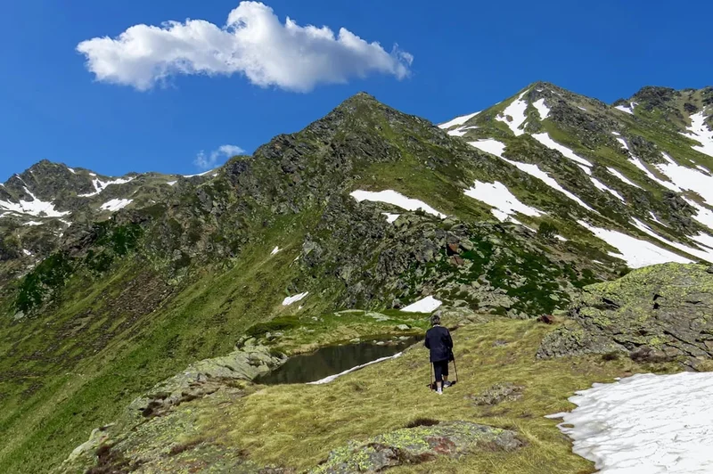
The Alta Via 1, or "High Route 1," is the quintessential long-distance trekking experience in the Italian Dolomites. Stretching approximately 120 kilometres from the emerald waters of Lago di Braies in the north to the historic town of Belluno in the south, this trail traverses the heart of a UNESCO World Heritage site. Unlike many alpine routes that require technical climbing skills, the Alta Via 1 is a walking route that stays primarily between 1,500 and 2,800 metres, offering accessible yet breathtaking access to some of the most dramatic limestone peaks on Earth. The journey is defined by the "Pale Mountains"—towering massifs of dolomite rock that glow with a fiery pink hue at sunrise and sunset, a phenomenon known locally as the Enrosadira. Over 10 to 12 days, hikers move through a landscape of stark contrast: from lush larch forests and high alpine meadows carpeted in wildflowers to desolate, lunar-like plateaus and jagged, vertical rock faces that have inspired climbers for centuries. This is more than a hike; it is a cultural immersion into the Ladin, Tyrolean, and Italian traditions that converge in these high valleys, supported by a network of world-class mountain huts (rifugios) that provide warm hospitality and hearty mountain cuisine at the end of every challenging day.
- Distance: 120 km one-way
- Duration: 10–12 days
- Season: July to September (rifugios typically open mid-June to late September)
- Accommodation: Mountain huts (rifugios) - mandatory booking in high season
- Highest point: Lagazuoi / Forcella Lagazuoi (2,752 m)
- Total Elevation Gain: Approximately 7,500 m
- Difficulty: Challenging (strenuous climbs, some exposed sections with cables, but no technical climbing required)
- Direction: North to South (Lago di Braies to Belluno)
Overview
The Alta Via 1 is widely considered the finest multi-day trek in the European Alps for those seeking a balance of physical challenge and aesthetic reward. The route avoids the valley floors, instead tracing a high-altitude line across the great massifs of the Eastern Dolomites, including the Fanes-Sennes-Prags, the Tofane, the Pelmo, and the Civetta. Each day presents a new geological masterpiece, from the iconic three-pronged peaks of the Tre Cime di Lavaredo (visible in the distance) to the sheer 1,000-metre rock wall of the Civetta, often called the "Wall of Walls" by mountaineers.
The trail's character changes as you progress south. The northern sections, beginning in the German-speaking South Tyrol (Südtirol), feature manicured paths and a distinct Tyrolean influence in the architecture and language. As you cross into the Veneto region and the province of Belluno, the landscape becomes wilder and more rugged, and the cultural atmosphere shifts toward a more traditional Italian mountain experience. The geology is equally varied; you will walk across the karst plateaus of Fanes, where water disappears into subterranean limestone caves, and navigate the steep, scree-filled gullies of the Schiara group near the trail's end. The path is well-marked with the distinctive "1" inside a triangle, but the terrain remains demanding, requiring steady feet and a head for heights on sections where the trail narrows alongside significant drops.
What sets the Alta Via 1 apart is the rifugio system. These are not merely shelters but high-altitude inns that serve as the social heart of the trail. After a day of ascending 1,000 metres, walkers are greeted with three-course meals, local wines, and the camaraderie of fellow trekkers from around the globe. This infrastructure allows for a "light" trekking experience compared to wilderness camping, as there is no need to carry tents, stoves, or large quantities of food. However, the physical demand remains high, with daily elevation gains often exceeding 800 metres and descents that test the resilience of even the strongest knees. The Alta Via 1 is a journey of endurance, beauty, and profound connection to one of the world's most unique mountain environments.
History and Cultural Context
The Dolomites are a landscape shaped by both geological time and human conflict. Geologically, these mountains are composed of fossilised coral reefs from the Triassic period, uplifted millions of years ago. The unique magnesium-rich limestone, named "dolomite" after the French mineralogist Déodat Gratet de Dolomieu, gives the peaks their characteristic pale colour and vertical geometry. This terrain, while beautiful, was the site of some of the most brutal mountain warfare in history during the First World War.
Between 1915 and 1918, the Dolomites formed part of the "Italian Front," where the Italian Alpini and the Austro-Hungarian Kaiserschützen fought a static but deadly war at high altitude. The Alta Via 1 passes directly through several of these historic battlefields, most notably at Lagazuoi and the Cinque Torri. Hikers can still explore the extensive network of tunnels, trenches, and barracks carved directly into the rock. The "Via Ferrata" (iron paths) that the Dolomites are famous for actually originated during this period, as soldiers installed fixed ropes and ladders to move troops and supplies across otherwise impassable cliffs. Today, these relics serve as a somber reminder of the region's past, and the Lagazuoi open-air museum is a mandatory stop for anyone walking the route.
Culturally, the trail traverses the Ladinia region, where the Ladin people have lived for over a thousand years. Ladin is a Rhaeto-Romance language, a linguistic relic of the Roman Empire's influence on the indigenous tribes of the Alps. You will notice that many signs are trilingual (Ladin, German, and Italian), and the local cuisine reflects this heritage—dishes like *casunziei* (beetroot-filled pasta) and *canederli* (bread dumplings) are staples of the rifugio menus. Understanding this blend of history and culture enriches the trekking experience, transforming the mountains from a mere physical obstacle into a living museum of European heritage.
Want more background? Read extended notes on history and cultural context → Learn more
Seasonal Highlights and Weather Reality
The trekking season on the Alta Via 1 is relatively short, dictated by the opening dates of the rifugios and the presence of snow on the high passes. Most hikers attempt the trail between early July and mid-September. Outside of this window, the risk of encountering impassable snow or finding closed accommodation is high.
July: This is the peak of the alpine spring. The meadows are an explosion of colour, with gentians, lilies, and the rare edelweiss in bloom. Days are long, but this is also the month with the highest frequency of afternoon thunderstorms. These storms can be violent and develop rapidly, making it essential to reach your destination or a safe shelter by mid-afternoon.
August: The most popular month for Italian holidaymakers. The trail is at its busiest, and rifugios must be booked months in advance. The weather is generally stable and warm, though the heat in the lower valleys can be intense. The high-altitude sections remain pleasantly cool, but water sources can begin to dry up, making it crucial to carry sufficient supplies.
September: Many experienced trekkers consider this the best time to walk. The crowds thin out, the air becomes crisp and exceptionally clear, and the light is perfect for photography. The risk of snow increases toward the end of the month, and temperatures at night can drop below freezing. By the final week of September, most rifugios begin to close for the winter season.
Winter and Shoulder Seasons: From October to June, the Alta Via 1 is an alpine environment requiring mountaineering skills. Heavy snowfall covers the markers, and many sections become high-risk avalanche zones. Only those with extensive winter navigation and survival experience should consider the route during these months, and they must be prepared for self-sufficiency as the huts are closed.
Recommended Itinerary
10-Day Alta Via 1 Itinerary
Day 1: Lago di Braies to Rifugio Biella
- Distance: 6 km
- Elevation gain: 900 m
- Time: 3.5–4 hours
- Start at the iconic Lago di Braies (Pragser Wildsee)
- Steep ascent under the Croda del Becco (Seekofel)
- Reach the high karst plateau of Sennes
- Arrive at Rifugio Biella (2,327 m), a rustic hut with stunning sunset views
- A short but demanding first day to test your mountain legs
Day 2: Rifugio Biella to Rifugio Fanes
- Distance: 14 km
- Elevation gain: 600 m
- Time: 5–6 hours
- Descend through the Sennes plateau toward Rifugio Pederü
- A steep descent followed by a steady climb into the Fanes-Sennes-Prags Nature Park
- Pass through the "Parliament of Marmots," a natural rock amphitheatre
- Arrive at Rifugio Fanes (2,060 m), known for its excellent Ladin cuisine
- The landscape transitions from stark rock to lush alpine pastures
Day 3: Rifugio Fanes to Rifugio Lagazuoi
- Distance: 12 km
- Elevation gain: 1,100 m
- Time: 6–7 hours
- Climb to Forcella del Lago, a dramatic notch in the ridge
- Steep descent to the turquoise Lago di Lagazuoi
- Long, steady climb to the summit of Mount Lagazuoi
- Arrive at Rifugio Lagazuoi (2,752 m), the highest point on the trail
- Incredible 360-degree views of the Marmolada glacier and Sella group
Day 4: Rifugio Lagazuoi to Rifugio Dibona or Cinque Torri
- Distance: 15 km
- Elevation gain: 400 m (1,000 m descent)
- Time: 5–6 hours
- Explore the WWI tunnels (optional) or descend via the ski run path
- Walk through the base of the Tofane massifs
- Pass the iconic Cinque Torri (Five Towers) rock formations
- Visit the WWI open-air museum at the base of the towers
- Stay at Rifugio Dibona or continue to Rifugio Scoiattoli
Day 5: Cinque Torri to Rifugio Città di Fiume
- Distance: 14 km
- Elevation gain: 600 m
- Time: 5–6 hours
- Cross the Passo Giau, one of the most beautiful road passes in the Dolomites
- Walk under the massive walls of Monte Nuvolau and Monte Averau
- Traverse high meadows with views of the Pelmo (the "Throne of God")
- Arrive at Rifugio Città di Fiume (1,918 m) at the base of Monte Pelmo
- A day of classic Dolomite panoramas and relatively gentle gradients
Day 6: Rifugio Città di Fiume to Rifugio Coldai
- Distance: 12 km
- Elevation gain: 800 m
- Time: 5–6 hours
- Descend to Passo Staulanza through forest and meadows
- Begin the long ascent toward the Civetta massif
- Pass the base of the Pelmo, looking for dinosaur footprints in the rocks
- Arrive at Rifugio Coldai (2,132 m) near the beautiful Lago Coldai
- The gateway to the spectacular Civetta "Wall of Walls"
Day 7: Rifugio Coldai to Rifugio Vazzoler or Carestiato
- Distance: 15 km
- Elevation gain: 800 m
- Time: 7–8 hours
- Walk the length of the Civetta's northwestern face
- Pass Rifugio Tissi for the best views of the 1,000 m vertical wall
- Descend through the Val Civetta, a wild and rocky valley
- Arrive at Rifugio Vazzoler (1,714 m) or continue to Carestiato
- One of the most physically demanding but visually rewarding days
Day 8: Rifugio Vazzoler to Rifugio Carestiato or Passo Duran
- Distance: 13 km
- Elevation gain: 600 m
- Time: 5–6 hours
- Traverse under the Moiazza massif, the southern extension of the Civetta
- Navigate rocky paths and some exposed sections with fixed cables
- Arrive at Rifugio Carestiato (1,834 m) with views over the Agordo valley
- The terrain becomes noticeably more rugged and less frequented
Day 9: Rifugio Carestiato to Rifugio Pramperet
- Distance: 13 km
- Elevation gain: 600 m
- Time: 6–7 hours
- Cross the Passo Duran and enter the Dolomiti Bellunesi National Park
- Climb into the wild San Sebastiano and Tamer groups
- Traverse high, lonely ridges far from the tourist crowds of the north
- Arrive at Rifugio Pramperet (1,857 m), a remote and peaceful hut
- Experience the true wilderness character of the southern Dolomites
Day 10: Rifugio Pramperet to La Pissa (Belluno)
- Distance: 12 km
- Elevation gain: 200 m (1,200 m descent)
- Time: 6–7 hours
- Final climb to the Forcella del de l'Orso
- Long, knee-jarring descent through the Val de l'Ardo
- Pass Rifugio Bianchet for a final mountain coffee
- Finish at the La Pissa bus stop on the main road to Belluno
- Take the local bus into the historic centre of Belluno for a celebratory meal
Planning and Bookings
Book Your Trip
Everything you need to plan your journey
Accommodation
Find places to stay near Cortina d'Ampezzo
Flights
Search flights to Cortina d'Ampezzo
Essential Preparation
The Alta Via 1 requires significant physical preparation and logistical planning. You should be comfortable walking 6–8 hours a day with a 10 kg pack, often on steep, rocky terrain. Training should include plenty of hill walking and stair climbing to prepare your legs for the 7,500 metres of ascent and descent. Coordination is key: you must book your rifugios in sequence, and because the trail is popular, this should be done 4–6 months in advance, especially for stays in July and August.
Cortina d'Ampezzo is the primary hub for the region, though the trail starts further north at Lago di Braies. Most hikers fly into Venice (Marco Polo or Treviso) and take the Cortina Express or ATVO bus to Cortina. From Cortina, local SAD buses run to Dobbiaco (Toblach) and then to Lago di Braies. Ensure you have a basic understanding of the bus schedules, as they can be infrequent on Sundays or public holidays.
Trail Accommodation
Accommodation on the Alta Via 1 is exclusively in rifugios (mountain huts). These range from large, hotel-like structures with private rooms to small, remote shelters with basic dormitories. Most hikers opt for "Mezza Pensione" (half-board), which includes dinner, breakfast, and a bed.
Hut Facilities:
- Dormitory-style sleeping (cuccette) with blankets and pillows provided
- Shared bathrooms and showers (showers often require a token, costing €3–€5 for 3 minutes of hot water)
- Common dining rooms serving multi-course Italian and Tyrolean meals
- Boot rooms for storing hiking boots (crocs or slippers are usually provided for indoor use)
- Limited charging points for electronics (bring a power bank)
- Drying rooms for wet gear (quality varies by hut)
What Rifugios Don't Provide:
- Towels or toiletries
- Sleeping bag liners (mandatory for hygiene in all huts)
- Free unlimited hot water
- Reliable WiFi or mobile signal (many huts are in "dead zones")
- Laundry services
Booking Requirements:
- Bookings must be made directly with each individual hut via email or their website
- A deposit is usually required to secure a bed
- Costs: Approximately €60–€90 per person per night for half-board
- Membership in an Alpine Club (like the CAI, ÖAV, or AAC) often provides a discount of €10–€15 per night
Required Gear
- Hiking boots: High-quality, waterproof, with a stiff sole for rocky terrain. Ensure they are well broken-in.
- Backpack: 30–40 litres is sufficient if staying in huts. Use a waterproof liner or rain cover.
- Clothing layers: Moisture-wicking base layers, a fleece or down mid-layer, and a high-quality waterproof shell (Gore-Tex).
- Trousers: Lightweight, quick-drying hiking trousers. Avoid denim.
- Socks: Merino wool blend to prevent blisters. Bring at least three pairs.
- Navigation: Tabacco Maps (1:25,000 scale) are the gold standard. Sheets 031, 03, and 024 cover the route.
- Safety gear: A basic first aid kit, emergency whistle, and a space blanket.
- Sun protection: High SPF sunscreen, sunglasses (Category 3 or 4), and a wide-brimmed hat.
What to Bring
- Sleeping bag liner: Silk or cotton (mandatory for hut stays).
- Cash: Many huts do not accept credit cards or have unreliable connections. Carry at least €400–€500 in cash for the duration.
- Water treatment: While tap water in huts is generally safe, a lightweight filter or tablets are useful for stream water.
- Personal toiletries: Biodegradable soap, toothbrush, and a small travel towel.
- Earplugs: Essential for sleeping in busy dormitories.
- Snacks: Energy bars, nuts, and dried fruit. Lunch can be purchased at huts, but having your own snacks is vital.
- Power bank: To keep your phone/camera charged when hut outlets are full.
- Head torch: For navigating dormitories at night or in case of late arrivals.
- Flip-flops or light indoor shoes: If you prefer your own over the provided hut slippers.
Permits
One of the great advantages of the Alta Via 1 is that no official permits are required to hike the trail or enter the national parks. Access is free and open to the public. However, the "permit" in a practical sense is your rifugio reservation. Because wild camping is strictly prohibited along the majority of the route, your ability to complete the trek depends entirely on securing a bed each night.
Booking Strategy:
- Start planning in January or February for a summer trek.
- Email huts directly in English or Italian. Be specific about dates and the number of people.
- If a hut is full, ask for recommendations for nearby alternatives (e.g., if Rifugio Lagazuoi is full, try Rifugio Dibona or Rifugio Scotoni).
- Keep a printed or digital copy of all confirmation emails and deposit receipts.
- If you need to cancel, do so as early as possible to allow others to take the spot and to potentially recover your deposit.
National Park Regulations:
- The trail passes through the Parco Naturale Fanes-Sennes-Braies and the Parco Nazionale Dolomiti Bellunesi.
- Wild camping is illegal and heavily fined. You must stay in huts.
- Drones are strictly prohibited in all national parks in the Dolomites.
- Stay on marked trails to prevent erosion and protect the fragile alpine flora.
Other Activities in the Area
The Dolomites offer a wealth of experiences beyond the Alta Via 1. Consider adding a few days to your itinerary to explore:
- Via Ferrata: If you have the gear and experience (or hire a guide), the Dolomites are the world capital of "iron paths." Iconic routes like the Innerkofler on Monte Paterno offer a thrilling vertical experience.
- Cortina d'Ampezzo: Spend a day in this glamorous mountain town, known for its high-end shopping, excellent restaurants, and Olympic history. It is a perfect place for a "rest day" mid-trek.
- The Great War Tunnels: Spend extra time at Lagazuoi exploring the incredible tunnel system. A head torch and helmet are recommended for safety.
- Rock Climbing: The Cinque Torri is one of the most famous rock climbing gardens in Europe, with routes for all ability levels.
- Venice: Since most hikers fly into Venice, spending a few days in the "City of Canals" before or after your trek provides a stunning cultural contrast to the mountains.
- Lake Garda: A few hours south of Belluno, Italy's largest lake offers sailing, windsurfing, and a Mediterranean climate to soothe tired muscles.
Safety and Conditions
Weather Awareness: The most significant objective hazard on the Alta Via 1 is the weather. Afternoon thunderstorms are common in July and August. These are often accompanied by lightning, which is extremely dangerous on exposed ridges and plateaus. Always aim to be off high passes and away from metal cables by 2:00 PM. Check the "Arpav Dolomiti Meteo" forecast every morning—it is the most accurate for the region.
Terrain and Exposure: While the Alta Via 1 is a walking trail, it includes sections of "exposure" where the path is narrow with a steep drop on one side. Some of these sections are equipped with a steel cable (handrail) for security. While a via ferrata kit is generally not required for the standard route, those with a severe fear of heights may find these sections challenging. The descent from the Schiara group on the final day is particularly steep and requires careful footwork.
Navigation: The trail is well-marked with the number "1" inside a triangle, painted on rocks and trees. However, in thick fog or cloud, these markers can be difficult to spot. Always carry a physical map and a compass, and know how to use them. GPS apps like Gaia GPS or AllTrails are excellent supplements but should not be your only source of navigation due to battery and signal limitations.
Emergency Procedures: In the event of an accident, the emergency number in Italy is 112. Mountain rescue (Soccorso Alpino) is highly professional but can be expensive if you do not have insurance. Ensure your travel insurance specifically covers "mountain search and rescue" and "hiking up to 3,000 metres."
Side Trips and Points of Interest
Galleria del Lagazuoi: Instead of the standard descent from Rifugio Lagazuoi, you can descend through a 1.1 km tunnel carved by Italian soldiers during WWI. It is a steep, dark, and damp experience that brings history to life. A head torch is mandatory, and a helmet is highly recommended as the ceiling is low in places.
Summit of Monte Pelmo: For very experienced hikers with extra time, the ascent of Monte Pelmo (3,168 m) via the "Ball Terrace" is a classic. It is a long, exposed scramble that requires a full day and stable weather. Most hikers are content to simply admire the mountain's "throne" shape from the main trail.
Cinque Torri Open-Air Museum: Located at the base of the Five Towers, this is one of the best-preserved WWI sites in the Alps. You can walk through reconstructed trenches and command posts, with informative plaques explaining the daily lives of the soldiers who lived here.
Lago di Coldai: A short 15-minute detour from Rifugio Coldai leads to this stunning alpine lake. It is a perfect spot for a cold dip (for the brave) and offers a magnificent reflection of the Civetta's peaks in the morning light.
Leave No Trace
The Dolomites are a fragile ecosystem under increasing pressure from tourism. As a UNESCO World Heritage site, it is our collective responsibility to ensure the landscape remains pristine. The Alta Via 1 passes through several protected areas where strict rules apply.
Core Principles for the Dolomites:
- No Wild Camping: This is the most important rule. Use the rifugios. Wild camping disturbs wildlife and leads to soil erosion and waste issues.
- Pack It In, Pack It Out: There are no rubbish bins on the trail. Even biodegradable items like banana peels or orange skins take years to decompose in the cold alpine air. Carry all trash back to the valleys.
- Respect the Flora: Do not pick wildflowers. Many species, such as the Lady's Slipper orchid or the Edelweiss, are protected by law.
- Stay on the Path: Short-cutting switchbacks causes massive erosion during heavy rains. Stick to the marked "1" trail.
- Water Conservation: Water is a precious resource in the karst limestone mountains. Use water sparingly in the rifugios and never use soap in alpine lakes or streams.
- Quiet Enjoyment: The Dolomites are a place of peace. Avoid loud music or shouting, which can disturb both wildlife and fellow trekkers.