The Dingle Way - A Journey Through Ireland's Wild Atlantic Heart
The Dingle Way (Slí Chorca Dhuibhne) is one of Ireland’s most celebrated long-distance walking routes, a 179-kilometre circular odyssey that encapsulates the raw, elemental beauty of the Dingle Peninsula in County Kerry. Starting and ending in the vibrant town of Tralee, the trail winds its way through a landscape that feels like a living museum, where ancient history, Gaelic culture, and the relentless power of the Atlantic Ocean collide. This is not merely a walk; it is a pilgrimage through time, traversing the emerald slopes of the Slieve Mish Mountains, the golden sands of Ventry and Fermoyle, and the high, mist-shrouded shoulders of Mount Brandon—Ireland’s second-highest peak. The route is designed to be accessible yet challenging, offering a perfect balance of rugged mountain tracks, quiet "boreens" (country lanes), and expansive coastal stretches that provide some of the most dramatic maritime vistas in Western Europe.
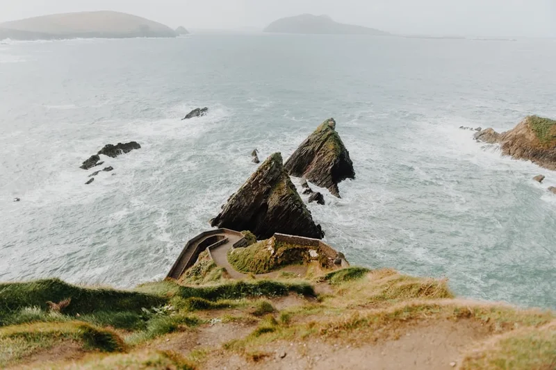
What sets the Dingle Way apart is its profound sense of place. As you travel westward, you enter the Gaeltacht—regions where the Irish language is still the primary tongue and where traditional music, folklore, and hospitality remain the bedrock of daily life. The trail is punctuated by an extraordinary density of archaeological sites, from prehistoric standing stones and Ogham pillars to early Christian beehive huts and medieval fortresses. Whether you are standing on the edge of the world at Dunmore Head, looking out toward the abandoned Blasket Islands, or navigating the high pass at Masatiompan, the Dingle Way offers a visceral connection to the land and its stories. It is a journey that demands stamina but rewards the walker with a deep sense of peace and a renewed appreciation for the untamed fringes of the European continent.
- Distance: 179.0 km circular route
- Total Elevation Gain: Approximately 4,000 m
- Duration: 7–9 days
- Difficulty: Moderate (with one strenuous mountain section)
- Best Time: April to September
- Closest City: Dingle (logistical hub) / Tralee (start/end point)
- Terrain: Mountain tracks, coastal paths, beaches, and quiet paved roads
Overview
The Dingle Way is a masterclass in topographical diversity. The peninsula itself is a narrow finger of land stretching 50 kilometres into the Atlantic, and the trail takes full advantage of this unique geography. The journey begins with a gentle introduction along the foothills of the Slieve Mish Mountains, offering views across Tralee Bay toward the Magharees. As the trail progresses westward, the landscape becomes increasingly dramatic. The southern coast is defined by rolling farmland and the historic ruins of Minard Castle, while the western tip—the most westerly point in Europe—is a jagged coastline of sheer cliffs and hidden coves where the Atlantic swell crashes against ancient sandstone.
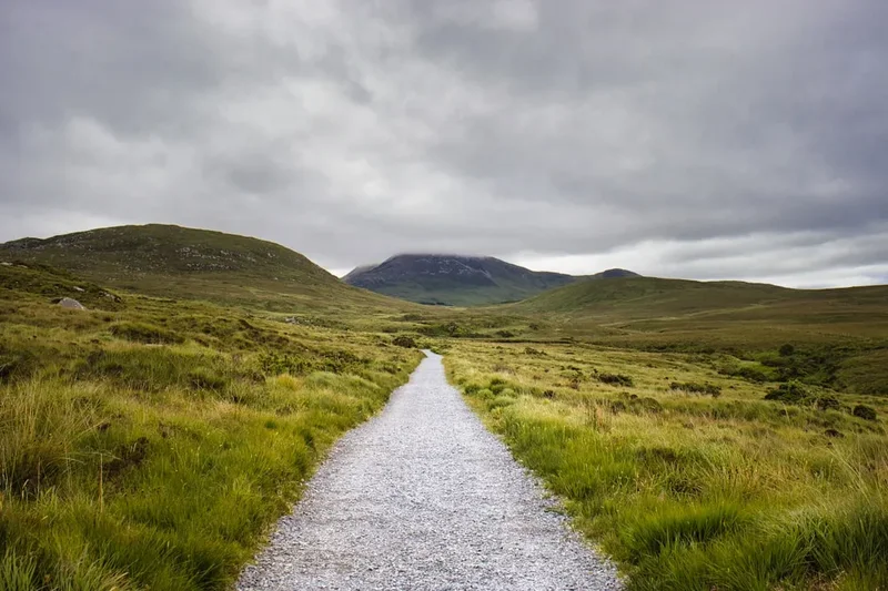
One of the defining characteristics of the Dingle Way is the variety of walking surfaces. Unlike many alpine trails that consist solely of dirt tracks, the Dingle Way incorporates significant stretches of beach walking. Traversing the 10-kilometre curve of Fermoyle Beach, with the surf on one side and the mountains on the other, is often cited by walkers as a meditative highlight of the trip. However, the trail also includes sections of "boreens"—narrow, stone-walled country lanes that connect remote farmsteads. While these sections are easier on the lungs, they require sturdy footwear to manage the hard surface over long distances. The physical crescendo of the route is undoubtedly the crossing of the shoulder of Mount Brandon. Reaching an elevation of 640 metres at the pass of Masatiompan, this section provides a genuine mountain experience, requiring navigation skills and physical resilience, especially when the Atlantic mists roll in.
Culturally, the Dingle Way is a journey into the heart of Irish identity. The peninsula is a stronghold of the Irish language (Gaeilge), and the trail passes through several "Gaeltacht" villages where the linguistic heritage is proudly preserved. The hospitality found in the small guesthouses and pubs along the route is legendary. After a day of battling the elements, there is no greater reward than a pint of stout and a session of traditional music in a Dingle or Dunquin pub. The trail is well-marked with the standard yellow "walking man" symbols, making it accessible to those with moderate hiking experience, though the sheer length and the unpredictable Irish weather ensure it remains a significant undertaking that commands respect.
History and Cultural Context
The Dingle Peninsula is often described as having the highest density of archaeological monuments in Western Europe, and the Dingle Way serves as a corridor through this ancient heritage. The history of the land is etched into every hillside. Walkers will encounter Ogham stones—ancient boundary markers or memorials featuring the earliest form of written Irish, consisting of a series of notches carved into the edges of the stone. These date back to the 4th and 5th centuries and represent a direct link to the Iron Age inhabitants of the peninsula.
The early Christian period has left perhaps the most visible mark on the landscape. The trail passes near the Gallarus Oratory, a dry-stone chapel built without mortar that has remained waterproof for over a thousand years. Its "inverted boat" shape is a marvel of Neolithic engineering applied to Christian worship. Nearby, the "clocháns" or beehive huts—conical stone dwellings used by monks and hermits—dot the slopes of Mount Brandon and Slea Head. These structures speak to a time when the peninsula was a centre of ascetic scholarship, attracting pilgrims from across Europe. Mount Brandon itself is named after Saint Brendan the Navigator, who, according to legend, set sail from this coast in the 6th century to discover the "Isle of the Blessed" (possibly North America) in a leather-clad boat.
More recent history is also palpable along the route. The ruins of Minard Castle, a 16th-century Fitzgerald stronghold, stand as a silent witness to the Cromwellian conquest of Ireland, having been partially destroyed by heavy artillery in 1650. The Great Famine of the 1840s also left its mark; the "famine ridges" or "lazy beds" (abandoned potato furrows) are still visible on many hillsides, a poignant reminder of the population collapse that devastated this region. The Blasket Islands, visible from the western sections of the trail, were inhabited until 1953. The islanders produced a remarkable body of literature in the Irish language, documenting a way of life that was both incredibly harsh and culturally rich. Today, the Dingle Way preserves this legacy, allowing walkers to step through layers of history that span five millennia.
Want more background? Read extended notes on history and cultural context → Learn more
Seasonal Highlights and Weather Reality
The Dingle Peninsula is subject to the full force of the Atlantic weather systems, meaning that conditions can change with startling rapidity. It is often said that in Kerry, you can experience four seasons in a single hour. The walking season typically runs from April to September, when the days are long and the temperatures are mild.
Spring (April to May): This is many locals' favourite time to walk. The gorse is in full yellow bloom, filling the air with a coconut-like scent, and the wildflowers—primroses, bluebells, and sea pinks—begin to carpet the cliffs. The weather is often drier than in mid-summer, though the wind can still be biting. The trail is quieter, and accommodation is easier to secure.
Summer (June to August): This is the peak season. The days are incredibly long, with twilight lasting until 10:30 PM in late June. The weather is at its warmest, typically ranging from 15°C to 20°C, though it rarely becomes uncomfortably hot. This is the best time for the beach sections and for enjoying the outdoor atmosphere in Dingle town. However, this is also the busiest time, and the "midge" (small biting insects) can be a nuisance on still, humid evenings near water or bogland.
Autumn (September to October): September is often a "golden month" with stable weather and the landscape turning rich shades of rust and purple as the heather fades. By October, the Atlantic storms begin to roll in with more frequency, and the mountain sections, particularly Mount Brandon, can become dangerous due to high winds and low visibility.
Winter (November to March): Walking the full Dingle Way in winter is only recommended for experienced hikers with high-quality gear. Many B&Bs and services close for the season, and the short daylight hours (sunset as early as 4:30 PM) limit progress. The mountain pass at Masatiompan can be treacherous with ice or heavy snow, and the coastal winds can reach gale force, making cliff-edge walking hazardous.
Recommended Itinerary
8-Day Dingle Way Itinerary
Day 1: Tralee to Camp
- Distance: 18 km
- Elevation gain: 250 m
- Time: 5–6 hours
- Start at the Kerry County Museum in Tralee
- Follow the canal path to Blennerville, home to a famous historic windmill
- Ascend the lower slopes of the Slieve Mish Mountains on a grassy track
- Enjoy views across Tralee Bay toward the Magharees peninsula
- Descend into the village of Camp for your first overnight stay
- A gentle introduction to the trail with moderate climbing
Day 2: Camp to Annascaul
- Distance: 17 km
- Elevation gain: 280 m
- Time: 5 hours
- Cross the peninsula from north to south
- Walk through the Emlagh valley and across rugged moorland
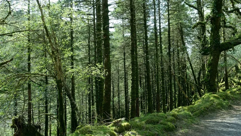
- Pass through a forest plantation before descending toward the southern coast
- Arrive in Annascaul, the home of legendary Antarctic explorer Tom Crean
- Visit the "South Pole Inn," the pub founded by Crean after his expeditions with Scott and Shackleton
- The terrain is a mix of quiet roads and mountain tracks
Day 3: Annascaul to Dingle
- Distance: 22 km
- Elevation gain: 340 m
- Time: 6–7 hours
- Follow a minor road to the spectacular ruins of Minard Castle on the shore
- Traverse farmland and "boreens" with views of the Iveragh Peninsula across the water
- Pass through the village of Lispole
- Climb over the shoulder of Conor Pass foothills before descending into Dingle town
- Dingle is the cultural hub of the peninsula, famous for its pubs, seafood, and resident dolphin (Fungie, though he is now gone, his legacy remains)
- A longer day with varied scenery and a rewarding finish
Day 4: Dingle to Dunquin
- Distance: 20 km
- Elevation gain: 380 m
- Time: 6 hours
- Walk along the shores of Ventry Harbour and across the long sands of Ventry Beach
- Enter the Gaeltacht region where Irish is the primary language
- Follow a stunning cliff-edge path around Slea Head
- Pass numerous archaeological sites, including the Fahan beehive huts
- View the Blasket Islands rising dramatically from the Atlantic
- Finish in Dunquin, the most westerly village in Europe
Day 5: Dunquin to Feohanagh
- Distance: 22 km
- Elevation gain: 120 m
- Time: 6–7 hours
- Walk along the rugged coastline of the "Wild Atlantic Way"
- Pass the iconic Clogher Strand, famous for its massive winter swells
- Traverse the foothills of Mount Brandon with the ocean to your left
- Pass through the village of Ballyferriter
- Relatively flat walking but exposed to the wind
- Arrive in the small settlement of Feohanagh
Day 6: Feohanagh to Cloghane (via Masatiompan)
- Distance: 21 km
- Elevation gain: 650 m
- Time: 7–8 hours
- The most challenging and spectacular day of the trail
- Ascend the shoulder of Mount Brandon to the pass at Masatiompan (640 m)
- Pass an ancient Ogham stone at the summit of the pass
- Steep descent on a zig-zag path with breathtaking views of Brandon Bay
- Follow a quiet road into the village of Cloghane
- Requires good visibility and fitness; an alternative low-level route is available via the Conor Pass road in bad weather
Day 7: Cloghane to Castlegregory
- Distance: 29 km
- Elevation gain: 50 m
- Time: 7–8 hours
- A long but flat day dominated by beach walking
- Walk the entire length of Fermoyle Beach, the longest beach in Ireland
- Continue along the coast of the Magharees peninsula
- Pass through sand dunes and alongside Scraggane Pier
- Arrive in the surfing village of Castlegregory
- The soft sand can be tiring on the calves, but the scenery is meditative
Day 8: Castlegregory to Tralee
- Distance: 27 km
- Elevation gain: 150 m
- Time: 7 hours
- Follow the coastline back toward Tralee Bay
- Pass through the village of Camp (completing the loop)
- Retrace the initial section of the trail back to Blennerville
- Finish at the Kerry County Museum in Tralee
- A long final push to complete the 179 km circuit
Important Notes:
- The route is circular; you can start at any point, but Tralee is the traditional beginning
- The Mount Brandon section (Day 6) should not be attempted in thick fog or gale-force winds
- Tidal awareness is necessary for some beach sections, though most have inland alternatives
- Accommodation should be booked well in advance, especially in July and August
- The trail is marked with yellow arrows; if you haven't seen one in 500 metres, you may have missed a turn
Planning and Bookings
Book Your Trip
Everything you need to plan your journey
Accommodation
Find places to stay near Dingle
Flights
Search flights to Dingle
Essential Preparation
The Dingle Way requires a moderate level of fitness. While much of the trail is on flat or undulating terrain, the cumulative distance of 179 kilometres over 8 days is a significant physical challenge. The most important preparation is "breaking in" your footwear. A large portion of the trail (approximately 30-40%) is on paved roads or hard-packed boreens, which can lead to blisters if your boots are too stiff or your socks are inadequate. Training walks of 15-20 kilometres on varied terrain are highly recommended.
Logistically, Tralee is the most convenient base. It is well-connected by train and bus to Dublin and Cork. Dingle town serves as a secondary hub mid-way through the walk and is excellent for restocking supplies. Many walkers choose to use a luggage transfer service (such as those provided by local tour operators), which moves your main bag from B&B to B&B each day, allowing you to walk with only a light daypack. This service must be organised in advance.
Trail Accommodation
The Dingle Way is a "village-to-village" walk, meaning you will stay in established settlements each night. There is a wide range of accommodation, but it fills up quickly during the summer months.
Types of Accommodation:
- Bed & Breakfasts (B&Bs): The most common option. These are usually family-run homes offering a private room and a full Irish breakfast. Expect to pay €50–€80 per person per night.
- Guesthouses and Hotels: Available in larger towns like Tralee, Dingle, and Castlegregory. These offer more amenities but at a higher price point.
- Hostels: Located in Tralee, Annascaul, Dingle, and Dunquin. These offer dormitory beds and communal kitchens, ideal for budget travellers.
- Camping: Official campsites are available in Camp, Dingle, and Castlegregory. Wild camping is generally discouraged as most of the land is private farmland with livestock. If you must wild camp, you must seek the landowner's permission and follow strict Leave No Trace principles.
Booking Requirements:
- Advance booking is essential for June, July, and August.
- Many B&Bs in remote areas like Feohanagh or Dunquin have limited rooms.
- Check if your accommodation offers packed lunches, as shops are scarce on some sections.
- Most B&Bs accept credit cards, but carrying some cash is advisable for smaller establishments.
Required Gear
- Walking Boots: Waterproof (Gore-Tex lined) with good ankle support. Ensure they are well broken-in.
- Waterproof Jacket: High-quality breathable waterproof (e.g., Gore-Tex) with a hood. Essential for the Irish climate.
- Waterproof Overtrousers: Lightweight and easy to pull on over boots.
- Layered Clothing: Moisture-wicking base layers (merino wool or synthetic), a fleece or down mid-layer, and trekking trousers (no denim).
- Socks: High-quality wool-blend hiking socks; consider "liner socks" to prevent blisters.
- Backpack: 25–35L daypack with a rain cover if using luggage transfer; 50–65L if carrying all gear.
- Navigation: Dingle Way Map Guide (1:50,000 scale), compass, and a GPS app (like Hiiker or AllTrails) with offline maps.
- First Aid Kit: Must include plenty of blister plasters (Compeed), antiseptic cream, and painkillers.
What to Bring
- Water Filtration: While tap water in B&Bs is safe, a reusable bottle or bladder (2L capacity) is essential. A filter (like a Sawyer Squeeze) is useful if you need to top up from mountain streams.
- Food and Snacks: High-energy snacks (nuts, chocolate, fruit). Most villages have a small "Centra" or "Spar" supermarket for daily supplies.
- Sun Protection: Sunscreen (SPF 30+), sunglasses, and a wide-brimmed hat. The Atlantic breeze can mask the intensity of the sun.
- Personal Items: Biodegradable toiletries, a small travel towel (if hostelling), and hand sanitiser.
- Power Bank: To keep your phone/GPS charged, as cold and wind can drain batteries quickly.
- Trekking Poles: Highly recommended for the Mount Brandon descent and for saving your knees on road sections.
- Cash: At least €100 in small notes for pubs, small shops, and honesty boxes.
Permits
One of the great advantages of the Dingle Way is that no permits or fees are required to walk the trail. The route is a public right-of-way that passes through a combination of public roads, state-owned land, and private farmland. Access is granted through the goodwill of local landowners and the work of the Dingle Way Committee.
Access Considerations:
- Private Land: Much of the trail crosses active sheep and cattle farms. It is a privilege, not a right, to cross this land. Always stay on the marked path and use the provided stiles to cross fences.
- Dogs: Dogs are strictly prohibited on many sections of the Dingle Way due to the presence of livestock. Even on a lead, dogs can disturb sheep, leading to conflict with farmers. It is best to leave pets at home.
- Groups: Large organised groups (more than 10 people) should contact the Dingle Way Committee or local tourism offices in advance to ensure they do not overwhelm small villages or narrow tracks.
- Mount Brandon: While no permit is needed, this is a serious mountain environment. In extreme weather, local authorities or the Mountain Rescue may advise against climbing. Always heed local advice.
Logistical Costs: While the trail itself is free, you should budget for accommodation, food, and transport. A typical 8-day trip costs between €600 and €1,000 per person, depending on the level of luxury chosen. Luggage transfer services typically cost around €10–€15 per bag per day.
Other Activities in the Area
The Dingle Peninsula is a world-class tourism destination. If you have extra days, consider these activities:
- Great Blasket Island Boat Trip: Take a ferry from Dunquin or Ventry to explore the abandoned village on the Great Blasket. It is a hauntingly beautiful place with a rich literary history and a massive colony of grey seals.
- Slea Head Drive: If you have a car, this is one of the world's most scenic drives. It follows much of the Dingle Way route but allows you to stop at more archaeological sites like the Reask Monastic Site.
- Traditional Music Sessions: Dingle town is the heart of Irish music. Pubs like O'Flaherty's, The Moorings, and Dick Mack's host nightly sessions where world-class musicians play in an informal setting.
- Sea Kayaking: Explore the sea caves of Dingle Harbour or Ventry Bay. It’s a great way to see the coastline from a different perspective and perhaps spot some local marine life.
- Surfing at Inch or Castlegregory: The peninsula has some of Ireland’s best surf breaks. Lessons are available for beginners at Brandon Bay.
- Distillery Tours: Visit the Dingle Distillery on the edge of town to learn about the production of Irish whiskey, gin, and vodka.
Safety and Conditions
Weather Awareness: The primary safety concern on the Dingle Way is the weather. Hypothermia is a risk even in summer if you are caught in heavy rain and high winds without proper gear. Always check the Met Éireann (Irish Meteorological Service) forecast specifically for "Munster" and "County Kerry" before setting out. If a "Status Orange" or "Red" wind warning is issued, do not attempt the coastal cliffs or mountain passes.
Navigation: While the trail is well-marked with yellow arrows, markers can be obscured by overgrown vegetation or knocked over by livestock. On the Mount Brandon pass (Masatiompan), the path can disappear in thick mist. You must be able to use a map and compass or a reliable GPS. If you lose the markers in the mist on the mountain, the safest course of action is to retrace your steps to the last known marker rather than wandering blindly.
Road Safety: A significant portion of the Dingle Way follows narrow country roads. These roads often have no hard shoulder and are used by local farmers and tourists. Always walk on the right-hand side (facing oncoming traffic), wear high-visibility clothing or a pack cover, and be prepared to step onto the verge to let vehicles pass.
Emergency Services: In the event of an accident, dial 999 or 112 and ask for "Mountain Rescue." Be prepared to give your coordinates or a description of nearby landmarks. Note that mobile phone signal can be patchy in the valleys and on the northern side of the peninsula.
Livestock: You will be walking through fields with sheep and occasionally cattle. Generally, they are used to walkers and will move away. However, never get between a cow and her calf. If cattle appear aggressive or block the path, give them a wide berth, even if it means briefly leaving the trail.
Side Trips and Points of Interest
Gallarus Oratory: Located between Dingle and Feohanagh, this is a must-see. It is a tiny, 1,300-year-old church built entirely of dry stone. The precision of the masonry is such that it remains completely watertight to this day. It is a profound example of early Christian devotion and architectural ingenuity.
The South Pole Inn: Located in Annascaul, this pub was owned by Tom Crean, the "Unsung Hero" of Antarctic exploration. The walls are lined with photographs and memorabilia from his voyages with Scott and Shackleton. It is a place of pilgrimage for adventure lovers.
Dunmore Head: The westernmost point of the Irish mainland. A short detour from the trail at Slea Head takes you to the tip of the headland, where you can look out at the "Dead Man" (Inishtooskert island) and feel the raw power of the Atlantic. This area was also a filming location for *Star Wars: The Last Jedi*.
Kilfountan Ogham Stone: Located just north of Dingle town, this standing stone features both Ogham script and a beautifully carved Christian cross, representing the transition from pagan to Christian Ireland.
Loch a' Dúin: For those with extra energy in Cloghane, a side trip into the valley of Loch a' Dúin reveals over 90 archaeological monuments, including wedge tombs, standing stones, and rock art, all set within a stunning glacial cirque.
Leave No Trace
The Dingle Peninsula is a fragile ecosystem and a working agricultural landscape. To ensure the trail remains open and beautiful for future generations, all walkers must adhere to the seven principles of Leave No Trace Ireland.
Specific Dingle Way Responsibilities:
- Plan Ahead and Prepare: Know your route and the weather. Avoid walking in large groups that can erode narrow paths.
- Travel on Durable Surfaces: Stay on the marked trail. Do not take shortcuts across fields, as this damages crops and can lead to soil erosion.
- Dispose of Waste Properly: "Pack it in, pack it out." This includes organic waste like banana skins and orange peels, which take a long time to decompose in the cool Irish climate. There are no bins on the trail; carry your rubbish to your next accommodation.
- Leave What You Find: Do not move stones from walls or archaeological sites. Do not pick wildflowers.
- Minimise Campfire Impacts: Fires are strictly prohibited along the trail due to the risk of bog fires. Use a lightweight stove if camping.
- Respect Wildlife and Livestock: Observe animals from a distance. Ensure all gates are closed exactly as you found them (either open or closed).
- Be Considerate of Others: Respect the privacy of local residents whose land you are crossing. Keep noise levels down and be courteous to other walkers.