Dhaulagiri Circuit Trek - Nepal's Hidden Gem
The Dhaulagiri Circuit Trek is an epic, challenging, and immensely rewarding journey through the heart of the Nepalese Himalayas, circumnavigating the seventh-highest mountain in the world, Dhaulagiri I (8,167 m). This remote and less-travelled circuit offers a profound immersion into raw, untamed wilderness, traversing high mountain passes, remote valleys, and traditional Sherpa villages. Unlike more popular treks, the Dhaulagiri Circuit demands self-sufficiency, excellent physical condition, and a spirit of adventure, rewarding those who undertake it with unparalleled solitude and breathtaking vistas of some of the planet's most formidable peaks.
- Distance: Approximately 220 km
- Duration: 18–21 days
- Season: October–November (autumn) and April–May (spring)
- Highest point: French Pass (5,360 m)
- Difficulty: Very Challenging
- Closest City: Pokhara
- Trailhead Access: Fly to Pokhara, bus to Beni, jeep to Darbang/Babiyachaur
Overview
The Dhaulagiri Circuit Trek is a true Himalayan expedition, a journey that takes you far from the beaten path into a realm of towering snow-capped giants and deep, rugged valleys. The trek begins with a gradual ascent from the subtropical foothills, passing through terraced fields and traditional villages, before entering the wilder, more remote landscapes that define the Dhaulagiri massif. The route is characterised by its dramatic elevation changes, from the warm valleys to the windswept alpine deserts and high mountain passes.
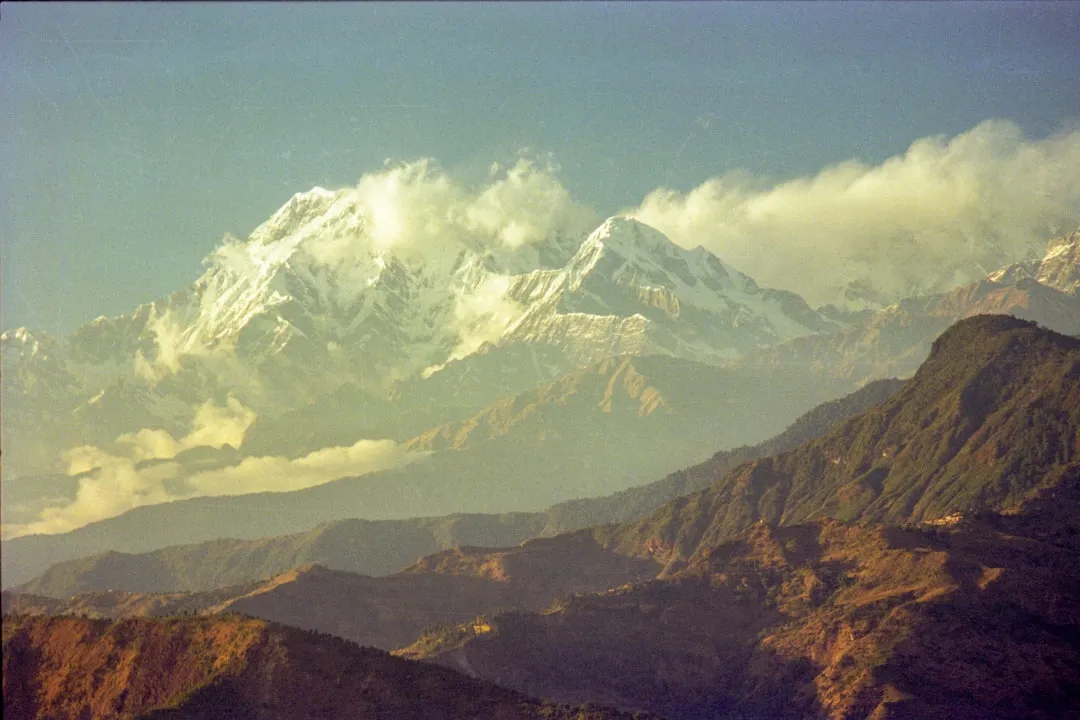
The trek's namesake, Dhaulagiri I, dominates the skyline for much of the journey. Its immense white mass, often shrouded in clouds, presents a constant, awe-inspiring presence. The circuit involves crossing two major passes: the Dhampus Pass (around 4,200 m) and the formidable French Pass (5,360 m), which is the highest point of the trek and a significant challenge requiring acclimatisation and good weather.
Beyond the sheer scale of the mountains, the Dhaulagiri Circuit offers a glimpse into the lives of the local communities, primarily Magar and Gurung people, who inhabit the lower reaches, and the hardy Sherpa communities found at higher altitudes. The trek is a test of endurance, navigation, and mental fortitude, but the rewards are immense: unparalleled views, a deep sense of accomplishment, and an intimate connection with the raw power of the Himalayas.
This trek is not for the faint-hearted. It requires careful planning, robust physical fitness, and a willingness to embrace the unpredictable nature of high-altitude trekking. The remoteness means that support is minimal, and self-reliance is key. However, for the experienced trekker seeking an authentic Himalayan adventure, the Dhaulagiri Circuit offers an unforgettable experience.
History and Cultural Context
The Dhaulagiri massif, meaning "White Mountain" in Sanskrit, has long been a sacred and imposing presence in the Nepalese Himalayas. While the lower valleys have been inhabited for centuries by various ethnic groups, including the Magar and Gurung people, the higher reaches remained largely unexplored by outsiders until the mid-20th century.
The first ascent of Dhaulagiri I was achieved in 1960 by a Swiss expedition led by Max Eiselin, who used a helicopter to establish a base camp at a higher altitude than previously thought possible. This marked a significant moment in mountaineering history and brought the "White Mountain" into the global spotlight.
The trekking routes around Dhaulagiri began to develop in the latter half of the 20th century, initially as extensions of expeditions or as routes for local porters and traders. The circuit as it is known today evolved as trekkers sought more challenging and less crowded alternatives to the Everest and Annapurna regions. The French Pass, a key feature of the circuit, is named after the French expedition that first crossed it in the early 1950s.
The cultural landscape of the Dhaulagiri region is rich and diverse. The lower parts of the trek pass through areas traditionally inhabited by Magar and Gurung communities, known for their agricultural practices and distinct cultural traditions. As the trek ascends, one encounters more isolated settlements, often with a strong Tibetan Buddhist influence, where Sherpa and other ethnic groups maintain a way of life deeply connected to the mountains and their spiritual significance.
The development of trekking infrastructure has been slow and organic in this remote region. Unlike more established routes, the Dhaulagiri Circuit relies heavily on basic teahouses and camping, preserving a sense of raw adventure and cultural authenticity. The region's relative isolation has helped maintain its traditional character, offering trekkers a genuine glimpse into rural Himalayan life.
Seasonal Highlights and Weather Reality
The Dhaulagiri Circuit Trek is best undertaken during two primary seasons, each offering distinct advantages and challenges:
Autumn (October–November): This is widely considered the prime trekking season for the Dhaulagiri Circuit. The monsoon rains have receded, leaving the skies clear and offering excellent visibility of the surrounding peaks. The air is crisp and cool, making for comfortable trekking conditions. Temperatures are generally moderate in the lower altitudes, becoming significantly colder at higher elevations, especially on the passes. Daytime temperatures can range from 10–20°C in the lower valleys to below freezing at altitudes above 4,000 metres. Nights can drop to -10°C or lower. The autumn colours in the lower forests add to the scenic beauty.
Spring (April–May): Spring is another excellent season for this trek. The snow from winter begins to melt, and the landscape comes alive with blooming rhododendrons and other wildflowers, particularly in the lower and mid-altitudes. The weather is generally stable, with clear mornings and often sunny days. However, spring can also bring occasional afternoon showers or thunderstorms, especially as the season progresses towards the monsoon. Temperatures are similar to autumn, with warmer days in the valleys and cold conditions at higher elevations. The higher passes may still have some lingering snow, but they are generally passable.
Monsoon (June–September): This season is generally not recommended for the Dhaulagiri Circuit. Heavy rainfall can lead to landslides, making trails impassable and dangerous. Visibility is poor due to persistent cloud cover, obscuring the magnificent mountain views. Trails can become muddy and slippery, and river crossings can be hazardous. While some trekkers might attempt it for solitude or to witness the lush green landscape, the risks and lack of views make it unsuitable for most.
Winter (December–March): Winter trekking is possible but extremely challenging and only recommended for experienced mountaineers with appropriate winter gear and expertise. The passes, particularly French Pass, can be buried under deep snow and are prone to avalanches. Temperatures are frigid, and the days are short. Most teahouses and lodges at higher altitudes may be closed.
Weather Considerations: Regardless of the season, weather in the Himalayas is notoriously unpredictable. High-altitude passes like French Pass are exposed to strong winds and can experience rapid changes in conditions, including snowstorms, even during the trekking seasons. It is crucial to be prepared for all types of weather, including cold, rain, snow, and strong winds, at any time of year.
Recommended Itinerary
18-Day Dhaulagiri Circuit Trek Itinerary
Day 1: Arrival in Kathmandu & Trek Preparation
- Arrive at Tribhuvan International Airport (KTM), Kathmandu.
- Transfer to your hotel.
- Rest and acclimatise.
- Final trek briefing and gear check.
- Obtain necessary permits.
Day 2: Fly to Pokhara & Trek Preparation
- Morning flight from Kathmandu to Pokhara (approx. 30 minutes).
- Transfer to your hotel in Pokhara.
- Enjoy the lakeside city and make any last-minute gear purchases.
- Final trek briefing with your guide.
Day 3: Drive to Beni & Trek to Bhalukhola
- Drive from Pokhara to Beni (approx. 4-5 hours).
- Begin trek from Beni.
- Walk through villages and terraced fields.
- Camp at Bhalukhola (approx. 1,000 m).
- Distance: ~15 km
- Time: ~5-6 hours
Day 4: Trek to Darbang & Dharapani
- Continue trekking along the Kali Gandaki River valley.
- Pass through small settlements.
- Reach Darbang, a larger village.
- Continue to Dharapani (approx. 1,570 m).
- Distance: ~18 km
- Time: ~6-7 hours
Day 5: Trek to Lumsung/Jaljala
- Ascend through rhododendron and oak forests.
- The trail becomes steeper as you gain altitude.
- Reach Lumsung or Jaljala (approx. 2,100 m) for camping.
- Distance: ~12 km
- Time: ~5-6 hours
Day 6: Trek to Gurja Gaon
- Continue through forests, with occasional glimpses of Dhaulagiri.
- Reach the village of Gurja Gaon (approx. 2,500 m).
- This is a significant Magar village.
- Distance: ~10 km
- Time: ~4-5 hours
Day 7: Trek to Dhaulagiri Base Camp (or nearby campsite)
- A challenging day as you head towards the higher altitudes.
- The trail becomes more rugged and exposed.
- Aim for a campsite near Dhaulagiri Base Camp (approx. 4,000 m).
- Distance: ~15 km
- Time: ~7-8 hours
Day 8: Acclimatisation Day / Explore Dhaulagiri Base Camp
- Rest and acclimatise to the altitude.
- Short hikes around the base camp to aid acclimatisation.
- Enjoy panoramic views of Dhaulagiri I, II, III, and other surrounding peaks.
Day 9: Trek to French Pass (or campsite below)
- A demanding day, crossing the high French Pass (5,360 m).
- Requires an early start and good weather.
- Descend slightly to a suitable campsite below the pass if conditions are difficult.
- Distance: ~10 km
- Time: ~7-9 hours
Day 10: Trek to Hidden Valley
- Descend from French Pass into the vast, hidden valley.
- This is a remote and stunning glacial valley.
- Camp in the Hidden Valley (approx. 5,000 m).
- Distance: ~8 km
- Time: ~4-5 hours
Day 11: Trek to Yak Kharka
- Begin the descent from the Hidden Valley.
- Pass through alpine meadows.
- Reach Yak Kharka (approx. 4,000 m).
- Distance: ~12 km
- Time: ~5-6 hours
Day 12: Trek to Marpha
- Continue descending towards the Kali Gandaki valley.
- Pass through villages like Chhoya and Puthang.
- Reach the picturesque Thakali village of Marpha (approx. 2,670 m), famous for its apple orchards.
- Distance: ~15 km
- Time: ~6-7 hours
Day 13: Trek to Ghasa
- Trek south along the Kali Gandaki River.
- Pass through Tukuche and Kalopani.
- Reach Ghasa (approx. 2,010 m), a village situated at the narrowest point of the Kali Gandaki gorge.
- Distance: ~20 km
- Time: ~7-8 hours
Day 14: Trek to Tatopani
- Continue descending along the Kali Gandaki.
- Pass through villages like Lete and Dana.
- Reach Tatopani (approx. 1,190 m), known for its natural hot springs.
- Distance: ~18 km
- Time: ~6-7 hours
Day 15: Drive to Pokhara
- Short trek to Ghara, then a drive back to Pokhara.
- The drive can be rough depending on road conditions.
- Arrive in Pokhara and check into your hotel.
- Distance: ~5 km trek + drive
- Time: ~2-3 hours trek + 4-5 hours drive
Day 16: Rest Day in Pokhara
- Relax and explore Pokhara.
- Enjoy a well-deserved rest after the trek.
- Optional activities: boating on Phewa Lake, visiting World Peace Pagoda.
Day 17: Fly to Kathmandu
- Morning flight from Pokhara to Kathmandu.
- Transfer to your hotel.
- Free time for souvenir shopping or sightseeing.
Day 18: Departure from Kathmandu
- Transfer to Tribhuvan International Airport for your departure.
Note: This itinerary is a guideline and can be adjusted based on weather conditions, acclimatisation, and the pace of the group. It is a challenging trek, and flexibility is key.
Planning and Bookings
Book Your Trip
Everything you need to plan your journey
Accommodation
Find places to stay near Pokhara
Flights
Search flights to Pokhara
Essential Preparation
The Dhaulagiri Circuit Trek is a serious undertaking that requires meticulous planning and preparation. Due to its remoteness and challenging terrain, it is highly recommended to undertake this trek with a reputable trekking agency. They will handle logistics such as permits, guides, porters, accommodation, and transportation, which are crucial for a safe and enjoyable experience.
Fitness: This trek demands exceptional physical fitness. You should be comfortable with long days of strenuous hiking, significant elevation gain and loss, and carrying a daypack. Regular cardiovascular exercise, strength training (especially for legs and core), and practice hikes with a weighted pack are essential. Prior experience with multi-day trekking at altitude is highly beneficial.
Acclimatisation: Proper acclimatisation is paramount to prevent altitude sickness. The itinerary includes a dedicated acclimatisation day at Dhaulagiri Base Camp and a gradual ascent to the high passes. It is vital to listen to your body, stay hydrated, and ascend slowly. Avoid alcohol and smoking at high altitudes.
Logistics: Flights to Kathmandu, followed by a flight to Pokhara, are the standard entry points. From Pokhara, a drive to Beni and then a jeep ride to Darbang or Babiyachaur is required to reach the trailhead. Road conditions can be poor, especially after monsoon rains, so allow for potential delays. Accommodation in Kathmandu and Pokhara before and after the trek should be booked in advance.
Base Town/City: Pokhara is the primary gateway city for the Dhaulagiri Circuit. It offers a wide range of accommodation, from budget guesthouses to luxury hotels, as well as numerous restaurants, gear shops, and trekking agencies. It's the last major hub for final preparations and supplies.
Trail Accommodation
Accommodation on the Dhaulagiri Circuit Trek varies significantly with altitude and remoteness. It primarily consists of basic teahouses (lodges) in the lower and mid-altitudes and camping at higher elevations.
Teahouses/Lodges:
- Availability: Found in villages like Dharapani, Gurja Gaon, Marpha, Ghasa, and Tatopani. They offer basic rooms with twin beds.
- Facilities: Typically provide a communal dining area with a stove for warmth and meals. Rooms are usually unheated. Shared toilet facilities are common, and showers (if available) may be cold or require an extra charge.
- What's NOT provided: Bedding (sleeping bags are essential), toiletries, towels, and personal items. Meals are ordered from a menu (Dal Bhat, noodles, rice, soup, tea, etc.).
- Seasonal Availability: Generally open year-round in inhabited villages, but may have reduced services or be closed during the harshest winter months.
- Costs: Room costs are usually nominal (e.g., $5–$15 USD per night), but meals are the primary expense.
Camping:
- Availability: Essential for the higher sections of the trek, including Dhaulagiri Base Camp, French Pass, and Hidden Valley.
- Facilities: Your trekking agency will provide tents, sleeping mats, cooking equipment, and a cook/kitchen crew. They will set up camp each evening.
- What's NOT provided: Personal camping gear (sleeping bag, mat), toiletries.
- Seasonal Availability: Campsites are generally accessible during the trekking seasons (spring and autumn).
- Costs: Included in the overall package price arranged with a trekking agency.
Note: This is a challenging trek, and the availability of teahouses can be sporadic. A combination of teahouse stays and camping is standard practice.
Required Gear
- Sturdy Trekking Boots: Waterproof, well-broken-in hiking boots with ankle support are essential.
- Waterproof Jacket: A high-quality, breathable waterproof jacket (e.g., Gore-Tex) with taped seams.
- Waterproof Overtrousers: Full-length zips are recommended for ease of use.
- Warm Layers: Multiple layers of thermal base layers (merino wool or synthetic), fleece jackets or down vests for insulation.
- Insulated Jacket: A warm down or synthetic insulated jacket for evenings and high-altitude passes.
- Sleeping Bag: A 4-season sleeping bag rated to at least -15°C to -20°C is crucial for camping and cold teahouse nights.
- Trekking Pack: A comfortable 50-70 litre trekking backpack with a rain cover.
- Daypack: A smaller pack (20-30 litres) for daily essentials if using porters for your main pack.
- Head Torch: With spare batteries.
- Sun Protection: High SPF sunscreen, lip balm with SPF, sunglasses (UV protection is vital at altitude), wide-brimmed hat or cap.
- First Aid Kit: Comprehensive kit including blister treatment, pain relievers, antiseptic wipes, bandages, personal medications, and altitude sickness medication (consult your doctor).
- Navigation: Map of the region, compass, and GPS device or smartphone with offline maps (though relying on a guide is standard).
- Trekking Poles: Highly recommended for stability and reducing strain on knees, especially on descents.
- Gaiters: To keep snow, mud, and debris out of your boots.
What to Bring
- Food: While teahouses provide meals, carrying high-energy snacks like energy bars, nuts, dried fruit, and chocolate is advisable for between meals and for the high-altitude sections where food options are limited.
- Water Treatment: Water purification tablets or a water filter are essential, as stream water should not be drunk untreated.
- Personal Toiletries: Biodegradable soap, toothbrush, toothpaste, wet wipes, hand sanitiser, toilet paper (can be scarce in remote areas).
- Quick-Dry Towel: Lightweight and fast-drying.
- Personal Medications: Any prescription medications you require.
- Camera: With spare batteries and memory cards.
- Power Bank: For charging electronic devices, as electricity is scarce at higher altitudes.
- Book/Journal: For downtime in teahouses or camps.
- Small amount of Cash: Nepalese Rupees for tips, drinks, snacks, and any personal expenses. ATMs are not available on the trek.
- Duct Tape: Invaluable for quick repairs to gear.
- Small Knife or Multi-tool.
- Water Bottles/Hydration Reservoir: At least 2-3 litres capacity.
Permits
Trekking in the Dhaulagiri region requires specific permits. These are typically arranged by your trekking agency as part of your package. It is crucial to ensure you have the correct permits before commencing your trek.
Required Permits:
- Annapurna Conservation Area Permit (ACAP): Even though the Dhaulagiri Circuit is distinct from the Annapurna Sanctuary, the initial access points and some parts of the route fall within the Annapurna Conservation Area. This permit helps fund conservation efforts and local community development.
- Dhaulagiri Conservation Area Permit (DCAP): This permit is specific to the Dhaulagiri region and is essential for trekking in this protected area.
- TIMS Card (Trekkers' Information Management System): While sometimes waived for those with ACAP/DCAP and organised tours, it's good practice to have one. It helps the government track trekkers for safety purposes.
Obtaining Permits:
- Trekking Agency: The most straightforward method is to have your chosen trekking agency handle the permit acquisition. They will require copies of your passport and passport-sized photographs.
- Nepal Tourism Board (NTB) / Department of Immigration: If arranging independently, permits can be obtained from the NTB office in Kathmandu or Pokhara.
Costs: Permit fees can vary, but generally, you can expect to pay approximately:
- ACAP: Around NPR 3,000 per person.
- DCAP: Around NPR 2,000 per person.
- TIMS Card: Around NPR 2,000 for individual trekkers or NPR 1,000 for trekkers organised by agencies.
It is advisable to carry your permits with you at all times, as they may be checked at various checkpoints along the trekking route.
Other Activities in the Area
While the Dhaulagiri Circuit Trek is the primary draw, the surrounding region offers several other points of interest and activities for those with extra time or seeking different experiences:
- Pokhara Exploration: Before or after your trek, spend time in Pokhara. Enjoy boating on Phewa Lake, visit the World Peace Pagoda for panoramic views, explore the International Mountain Museum, or relax in the vibrant lakeside cafes and restaurants.
- Paragliding in Pokhara: For adrenaline seekers, Pokhara offers world-class paragliding with stunning views of the Annapurna range and Phewa Lake.
- Bungee Jumping and Zip-lining: Adventure activities are plentiful in the Pokhara region.
- Short Treks from Pokhara: If time permits, consider shorter treks like the Poon Hill trek (Ghorepani Poon Hill) for iconic sunrise views of the Annapurna and Dhaulagiri ranges, or the Mardi Himal trek for a more remote experience in the Annapurna region.
- Exploring Marpha Village: The village of Marpha, on the Dhaulagiri Circuit itself, is renowned for its apple orchards and apple brandy. It's a charming place to spend an extra day exploring its narrow, paved alleys and unique architecture.
- Hot Springs at Tatopani: The natural hot springs at Tatopani offer a perfect opportunity to relax and soothe tired muscles after days of trekking.
- Cultural Immersion: Engage with the local Magar, Gurung, and Thakali communities in the villages along the lower parts of the trek. Learn about their traditions, lifestyles, and hospitality.
Safety and Conditions
Altitude Sickness (AMS): This is the most significant risk on the Dhaulagiri Circuit. Symptoms include headache, nausea, dizziness, fatigue, and loss of appetite. Prevention is key: ascend slowly, acclimatise properly, stay hydrated, and avoid alcohol and smoking. If symptoms appear, do not ascend further; descend immediately if symptoms worsen. Your guide will monitor you closely.
Weather: Himalayan weather is unpredictable. Be prepared for extreme cold, strong winds, snow, and rain, even during the trekking seasons. Passes like French Pass can be treacherous in bad weather. Always check forecasts with your guide and be ready to alter plans.
Trail Conditions: Trails can be steep, rocky, and slippery, especially after rain or snow. Sections around the high passes can be exposed and require careful footing. Landslides are a risk during and immediately after the monsoon season.
Remoteness: The Dhaulagiri Circuit is remote, with limited access to medical facilities. Evacuation by helicopter may be necessary in emergencies, which is expensive. Comprehensive travel insurance covering high-altitude trekking and emergency evacuation is mandatory.
Guides and Porters: Hiring experienced, licensed guides and porters is highly recommended. They are familiar with the terrain, weather patterns, and local culture, and can provide invaluable assistance in emergencies. Ensure your agency provides adequate insurance and equipment for their staff.
Communication: Mobile phone reception is sporadic and generally unavailable at higher altitudes. Satellite phones are sometimes carried by guides for emergencies.
Water and Food Safety: Drink only purified or boiled water. Be cautious with food hygiene in teahouses; stick to well-cooked meals. Your trekking agency will manage food safety during camping sections.
Pre-Trek Health Check: Consult your doctor before your trip to discuss vaccinations, altitude sickness medication, and any personal health concerns.
Side Trips and Points of Interest
Dhaulagiri Base Camp: While a stop on the main itinerary, spending an extra day here for acclimatisation allows for deeper appreciation of the massif's grandeur. Short hikes around the camp offer different perspectives of Dhaulagiri I, II, III, and the surrounding peaks.
French Pass Views: The summit of French Pass (5,360 m) offers arguably the most spectacular panoramic views of the entire Dhaulagiri massif, including Dhaulagiri I, II, III, IV, V, and the surrounding peaks like Tukuche Peak and Dhampus Peak. On a clear day, the vista is simply breathtaking.
Hidden Valley Exploration: The vast, high-altitude Hidden Valley is a unique glacial basin. While the main trek passes through, spending an extra day here could allow for exploration of its glacial features and offer a profound sense of isolation and wilderness.
Marpha Village: This charming Thakali village is a highlight for many. Its unique architecture, paved alleys, and apple orchards make it a delightful place to explore. An extra day here allows for a more relaxed experience, perhaps visiting a local monastery or enjoying the local apple products.
Tatopani Hot Springs: After descending from the high passes, the natural hot springs at Tatopani provide a perfect opportunity for relaxation and recovery. Spending a night here allows ample time to enjoy the therapeutic waters.
Cultural Villages: The villages of Gurja Gaon, Ghasa, and others along the lower sections offer insights into the lives of the Magar, Gurung, and Thakali people. Engaging with locals, observing their daily routines, and learning about their traditions can be a rewarding experience.
Leave No Trace

The Dhaulagiri Circuit Trek traverses pristine and fragile Himalayan environments. Adhering to Leave No Trace principles is paramount to preserving this wilderness for future generations and respecting the local culture.
Plan Ahead and Prepare: Understand the challenges of the trek, pack appropriately, and be prepared for varying conditions. Hiring local guides and porters supports the local economy and ensures you have experienced individuals to rely on.
Travel and Camp on Durable Surfaces: Stick to established trails and campsites. Avoid walking on fragile vegetation, especially in alpine meadows. When camping, use designated sites or choose durable surfaces like rock or gravel.
Dispose of Waste Properly: Pack out everything you pack in, including all food scraps, wrappers, and toilet paper. Use designated toilets where available. If no toilets are available, dig catholes at least 60 metres away from water sources, trails, and campsites.
Leave What You Find: Do not remove natural objects (rocks, plants) or cultural artifacts. Respect historical sites and local traditions.
Minimise Campfire Impacts: Campfires are generally not permitted on this trek due to the scarcity of firewood and the risk of wildfires. Use portable stoves for cooking.
Respect Wildlife: Observe wildlife from a distance. Do not feed animals, as it can disrupt their natural behaviours and diets. Be aware of potential encounters with yaks or other livestock.
Be Considerate of Other Visitors: Keep noise levels down, especially in teahouses and campsites. Respect the local culture and traditions. A friendly greeting ("Namaste") goes a long way.
By following these principles, you contribute to the sustainability of trekking in the Himalayas and ensure a positive experience for yourself and others.