Cuesta del Obispo Hike
The Cuesta del Obispo (Bishop's Slope) hike is a spectacular day walk located in the heart of the Calchaquí Valleys in Salta Province, Argentina. This trail offers breathtaking panoramic views of the surrounding Andes mountains, dramatic geological formations, and a sense of remote wilderness. It's a challenging yet rewarding trek that showcases the raw beauty of the high-altitude desert landscape, making it a must-do for adventurous hikers visiting the region.
- Distance: 19.3 km one-way
- Elevation gain: 1100 m
- Duration: 6-8 hours
- Difficulty: Moderate to Challenging
- Best Time: April to November (dry season)
- Closest City: Salta
- Trailhead Access: Via Route 33, near the summit of Cuesta del Obispo
Overview
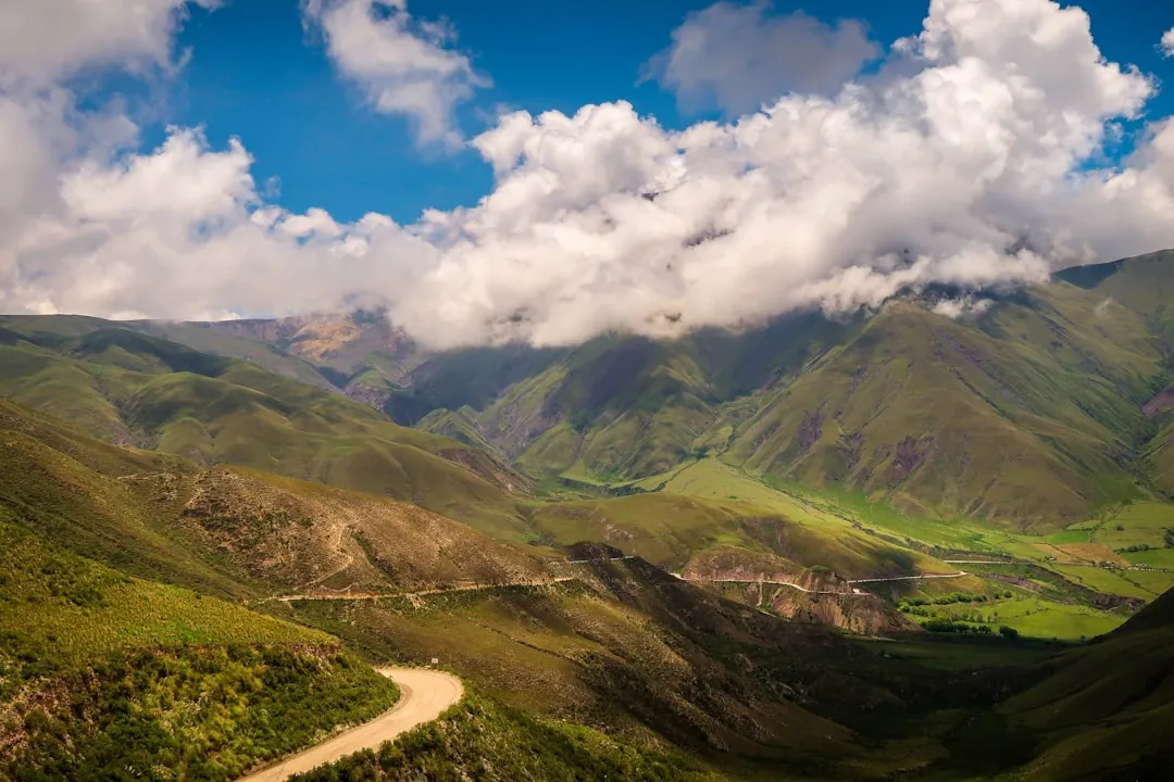
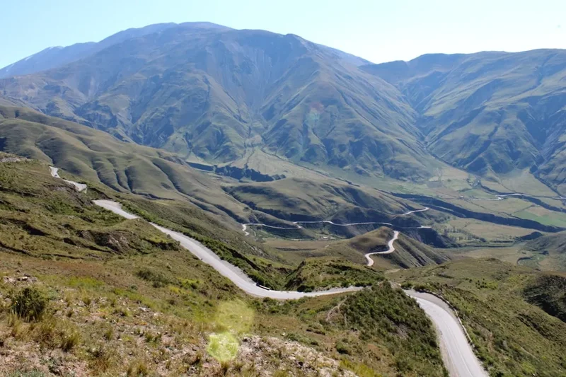
The Cuesta del Obispo hike is a journey through a landscape sculpted by wind, water, and time. Starting from a high point on the iconic Cuesta del Obispo road, the trail descends into a vast, arid valley, offering ever-changing vistas. The path winds through rocky terrain, sparse vegetation adapted to the harsh climate, and past unique geological formations that tell the story of the region's ancient past. The elevation gain and loss, combined with the high altitude, make this a physically demanding day walk, but the unparalleled scenery and the feeling of solitude are immense rewards.
The trail is characterised by its dramatic elevation changes. While the starting point is already at a significant altitude, the hike involves a substantial descent followed by a strenuous ascent, or vice versa depending on the direction of travel. The terrain is often loose scree and rocky, requiring careful footing. The vegetation is sparse, consisting mainly of hardy shrubs, cacti, and grasses that cling to the arid slopes. The colours of the landscape are striking, with ochre, red, and brown hues dominating the rock faces, contrasted by the deep blue of the sky.
This hike is best undertaken during the dry season, from April to November, when the weather is more predictable and the chances of rain are minimal. During the wet season, the trails can become treacherous, and visibility can be severely reduced. The high altitude means that even in summer, temperatures can drop significantly, especially in the early morning and late afternoon. Proper preparation is key to enjoying this challenging but incredibly scenic trek.
History and Cultural Context
The Cuesta del Obispo itself is a historic route, named after the bishop who, according to legend, was the first to traverse this challenging mountain pass in the 17th century. The route has long been a vital connection between the city of Salta and the western regions of the province, including the picturesque town of Cachi. For centuries, this path was used by indigenous peoples, Spanish colonisers, and later by merchants and travellers, all navigating the formidable Andean terrain.
The geological history of the area is vast, with rock formations dating back millions of years. The Calchaquí Valleys are known for their rich fossil beds and unique geological structures, shaped by tectonic activity and erosion. The indigenous cultures of the region, such as the Diaguita-Calchaquí people, have inhabited these valleys for millennia, leaving behind archaeological evidence of their sophisticated societies, including terraced agriculture and intricate pottery.
While the Cuesta del Obispo hike is not associated with specific historical events in the same way as some ancient trails, it traverses a landscape that has been a silent witness to centuries of human passage and geological change. The very name "Cuesta del Obispo" evokes a sense of historical exploration and the enduring human desire to conquer challenging landscapes. Today, the area is a popular destination for tourists seeking adventure and a connection to Argentina's natural and historical heritage.
Seasonal Highlights and Weather Reality
The Cuesta del Obispo hike is best experienced during the dry season, which typically runs from April to November. This period offers the most stable weather conditions, with clear skies and minimal rainfall, making it ideal for high-altitude trekking.
Spring (September to November): This is a fantastic time to hike. The weather is generally mild, with daytime temperatures pleasant for walking. The sparse vegetation may show signs of life, and the skies are usually clear, offering excellent visibility of the surrounding mountains. However, early spring can still experience cold snaps, and late spring might see occasional rain showers.
Autumn (April to June): Autumn is arguably the prime season. The summer heat has subsided, and the days are crisp and cool. The colours of the landscape can be particularly striking, with the arid vegetation taking on golden hues. Rainfall is minimal, and the skies are typically clear, providing stunning photographic opportunities. Nights can be cold, so warm layers are essential.
Winter (July to August): While still within the dry season, winter can bring significantly colder temperatures, especially at higher elevations. Snowfall is possible, particularly on the higher passes, which could impact trail conditions. Daytime temperatures might be cool but manageable with appropriate gear, but mornings and evenings will be very cold. The clear, crisp air can offer spectacular views, but hikers must be prepared for sub-zero temperatures.
Summer (December to March): This is the wet season in the region. While daytime temperatures can be warm, there is a high chance of afternoon thunderstorms. These storms can bring heavy rain, lightning, and flash floods, making the trails dangerous and potentially impassable. Visibility can be severely reduced, and the risk of hypothermia increases. It is generally not recommended to hike the Cuesta del Obispo during the peak of the wet season unless you are an experienced mountaineer with excellent weather forecasting skills and appropriate safety equipment.
Weather Considerations: Regardless of the season, weather in the Andes can change rapidly. Always check the local forecast before you set out and be prepared for a wide range of conditions, including strong winds, sudden temperature drops, and unexpected precipitation, even during the dry season.
Recommended Itinerary
Cuesta del Obispo Day Hike Itinerary
This itinerary assumes a start from the highest point of the Cuesta del Obispo road and a descent into the valley, followed by an ascent back to the road. This direction is often preferred as it allows for a more gradual introduction to the terrain and a challenging but rewarding finish.
Early Morning (Approx. 7:00 AM - 8:00 AM): Travel to Trailhead
- Depart from Salta or your accommodation in a rental car or pre-arranged taxi/tour.
- The drive to the trailhead takes approximately 2-3 hours, depending on road conditions and traffic.
- The trailhead is located near the summit of the Cuesta del Obispo, a well-known viewpoint on Route 33.
- Ensure you have sufficient fuel, as services are limited along the route.
Morning (Approx. 9:00 AM - 10:00 AM): Start of the Hike - Descent into the Valley
- Begin the hike from the designated parking area near the summit of Cuesta del Obispo.
- The initial section involves a steep descent into the valley.
- Terrain: Loose scree, rocky paths, and some sections of packed earth.
- Elevation loss: Significant, approximately 600-700 metres over the first few kilometres.
- Key Waypoints: Follow the most discernible path downwards, keeping an eye out for cairns or markers if present. The landscape opens up dramatically as you descend.
Midday (Approx. 12:00 PM - 2:00 PM): Valley Floor and Lunch Break
- Reach the valley floor, which is relatively flatter but still rugged.
- The trail may become less distinct in places, requiring careful navigation.
- Find a sheltered spot to enjoy your packed lunch and rehydrate.
- Observe the unique flora and fauna adapted to this arid environment.
- Key Waypoints: Look for distinctive rock formations or dry riverbeds that can serve as navigation aids.
Afternoon (Approx. 2:00 PM - 5:00 PM): Ascent and Return to Trailhead
- Begin the strenuous ascent back towards the Cuesta del Obispo road.
- Terrain: Steep, rocky, and potentially loose scree. This is the most physically demanding part of the hike.
- Elevation gain: Approximately 1100 metres in total from the lowest point.
- Pace yourself, take regular breaks, and ensure you are well-hydrated.
- Key Waypoints: The goal is to reach the visible road above. Follow the most direct and safest ascent route, which may involve switchbacks or a more direct climb depending on the terrain.
Late Afternoon (Approx. 5:00 PM - 6:00 PM): Completion of Hike and Return Journey
- Arrive back at the trailhead near the summit of Cuesta del Obispo.
- Celebrate your accomplishment!
- Begin the drive back to Salta or your accommodation.
- Consider stopping at viewpoints along the Cuesta del Obispo for sunset photos if time and daylight permit.
Alternative Itinerary (Ascent First):
Some hikers may prefer to start at a lower point on Route 33 and ascend to the summit. This involves a sustained climb throughout the hike, which can be more challenging for some. The views on the ascent are also spectacular, offering a different perspective.
Important Notes:
- This is a strenuous day hike due to elevation and terrain.
- Carry ample water (at least 3-4 litres per person) and high-energy snacks.
- Navigation skills are essential, especially if trail markers are absent or unclear. A GPS device or offline map is highly recommended.
- Start early to avoid the midday heat and allow ample time for the descent and ascent.
- Inform someone of your hiking plans, including your expected return time.
Planning and Bookings
Book Your Trip
Everything you need to plan your journey
Accommodation
Find places to stay near Salta
Flights
Search flights to Salta
Essential Preparation
The Cuesta del Obispo hike is a significant undertaking that requires careful planning. Given its remote location and challenging terrain, thorough preparation is paramount. The closest major city is Salta, which serves as the primary base for most travellers. From Salta, you will need to arrange transportation to the trailhead, which is approximately a 2-3 hour drive via Route 68 and then Route 33.
Fitness: This hike demands a good level of cardiovascular fitness and leg strength. The significant elevation gain and loss, combined with the high altitude (the trailhead is around 3,000 metres above sea level), can be taxing. It is advisable to acclimatise to the altitude in Salta for at least a day or two before attempting the hike. If you are not accustomed to high altitudes, consider shorter walks at lower elevations first.
Logistics: Hiring a car in Salta provides the most flexibility for reaching the trailhead. Ensure the vehicle is suitable for mountain roads, which can be winding and steep. Alternatively, you can hire a taxi or join a guided tour. Guided tours are highly recommended for first-time visitors as they provide transportation, navigation expertise, and local knowledge, significantly enhancing safety and enjoyment.
Base Town: Salta is the ideal base. It offers a wide range of accommodation options, from budget hostels to luxury hotels, as well as numerous restaurants, gear shops, and tour operators. Allow at least one full day in Salta for acclimatisation and final preparations before heading to the trailhead.
Trail Accommodation
This is a day hike requiring no overnight accommodation. Hikers typically start from Salta or a nearby town, complete the hike within a single day, and return to their accommodation.
Required Gear
- Sturdy hiking boots: Waterproof and with good ankle support are essential for navigating the rocky and uneven terrain. Ensure they are well broken-in to prevent blisters.
- Backpack: A comfortable daypack (20-30 litres) to carry essentials.
- Navigation tools: A reliable GPS device or smartphone with offline maps (e.g., Maps.me, Gaia GPS) and a compass. Trail markers can be scarce.
- Headlamp or torch: With spare batteries, in case of unexpected delays or an early start/late finish.
- First-aid kit: Including blister treatment, pain relievers, antiseptic wipes, bandages, and any personal medications.
- Sun protection: High SPF sunscreen, sunglasses, and a wide-brimmed hat are crucial due to the intense high-altitude sun.
- Insect repellent: While not as prevalent as in other regions, biting insects can be present, especially near water sources.
- Trekking poles: Highly recommended for stability on descents and to reduce strain on knees during ascents.
- Waterproof and windproof jacket: Weather can change rapidly in the mountains.
- Warm layers: A fleece or down jacket, and thermal base layers, as temperatures can drop significantly, especially at higher elevations and in the shade.
What to Bring
- Water: Carry at least 3-4 litres of water per person. Water sources may be scarce or unreliable, and treating water is recommended if you plan to refill.
- Food: High-energy snacks and a substantial packed lunch. Options include nuts, dried fruit, energy bars, sandwiches, and jerky.
- Toiletries: Hand sanitiser, toilet paper, and a small trowel for burying human waste if no facilities are available (though for a day hike, carrying out all waste is preferred).
- Personal items: Camera, power bank for electronics, identification, and some cash for emergencies or potential small purchases.
- Emergency whistle: For signalling in case of distress.
- Duct tape: Useful for quick repairs to gear or boots.
Permits
Generally, no specific permits are required for hiking the Cuesta del Obispo trail itself. The area is part of the provincial landscape and is accessible to the public. However, it is always advisable to check with local authorities or the Salta tourism office for any updated regulations or specific requirements, especially if you plan to camp (which is not recommended for this day hike due to the lack of facilities and potential for extreme weather).
Important Considerations:
- National Park Regulations: While not a national park, the area is managed by provincial authorities. Respect any posted signs or guidelines regarding environmental protection.
- Road Access: The Cuesta del Obispo road is a public highway. Be aware of vehicle traffic, especially if you are hiking near the road or crossing it.
- Guided Tours: If you opt for a guided tour, the tour operator will typically handle any necessary arrangements or provide information on local regulations.
Other Activities in the Area
The region surrounding Cuesta del Obispo offers a variety of activities for visitors looking to extend their stay or explore beyond the hike:
- Explore Salta City: Discover the colonial architecture, vibrant culture, and excellent museums of Salta, often called "Salta la Linda" (Salta the Beautiful).
- Visit Cachi: A charming colonial town nestled at the foot of the Andes, known for its white adobe buildings, artisan crafts, and the stunning Los Cardones National Park nearby.
- Drive the Calchaquí Valleys: Embark on a scenic road trip through the Calchaquí Valleys, visiting towns like Molinos, Seclantás, and San Carlos, each with its unique character and history.
- Explore Los Cardones National Park: This park is famous for its vast fields of giant cacti and its significant fossil deposits, including ancient petrified trees.
- Wine Tasting: The high-altitude vineyards of the Calchaquí Valleys produce some of Argentina's finest wines, particularly Torrontés. Many bodegas offer tours and tastings.
- Hiking in other areas: The Salta region offers numerous other hiking opportunities, from shorter walks in national parks to multi-day treks in more remote mountain ranges.
- Cultural Experiences: Immerse yourself in the local culture by visiting peñas (traditional folk music venues), exploring artisan markets, and sampling regional cuisine.
Safety and Conditions
Altitude Sickness: The Cuesta del Obispo trailhead is at approximately 3,000 metres above sea level, and the hike involves significant elevation changes. Altitude sickness (soroche) can affect anyone, regardless of fitness level. Symptoms include headache, nausea, dizziness, and fatigue. Acclimatise in Salta for at least 24-48 hours before hiking. If symptoms worsen, descend immediately.
Weather: Mountain weather is unpredictable. Be prepared for rapid changes, including strong winds, sudden temperature drops, and potential rain or even snow, especially outside the peak dry season. Check the forecast before you go, but always carry layers and waterproof gear.
Navigation: The trail can be poorly marked or indistinct in places, especially on the descent and ascent sections. Relying solely on visual cues can be risky. A GPS device or a reliable offline map app on your smartphone is essential. Inform someone of your hiking plans, including your expected return time and route.
Terrain: The trail consists of loose scree, rocky paths, and steep slopes. Proper hiking boots with good grip and ankle support are crucial. Trekking poles can significantly aid stability and reduce the impact on your joints.
Water and Food: Carry more water than you think you will need (at least 3-4 litres per person). Water sources are scarce and may not be potable. High-energy snacks are vital to maintain stamina.
Sun Exposure: The sun at high altitudes is intense. Use high SPF sunscreen, wear a hat and sunglasses, and cover exposed skin to prevent sunburn and heatstroke.
Emergency Contacts: Have local emergency numbers readily available. If you are on a guided tour, your guide will be your primary point of contact. If hiking independently, consider carrying a personal locator beacon (PLB) or satellite phone for remote areas.
Vehicle Access: If driving yourself, ensure your vehicle is in good condition and suitable for mountain roads. Be aware of other vehicles on the Cuesta del Obispo road, which can be narrow and winding.
Side Trips and Points of Interest
While the Cuesta del Obispo hike is a substantial day trip in itself, the surrounding area offers several points of interest that can be incorporated into your visit or explored separately:
The Summit Viewpoint: The starting and ending point of the hike, located at the highest point of the Cuesta del Obispo road, offers breathtaking panoramic views of the surrounding Andes, the vast Calchaquí Valleys, and the winding road itself. This is an excellent spot for photography, especially during sunrise or sunset.
Geological Formations: As you descend and ascend, you will encounter a variety of fascinating rock formations and geological strata. These are a testament to millions of years of geological activity, including volcanic eruptions and tectonic shifts. Keep an eye out for unusual patterns and colours in the rock faces.
Unique Flora and Fauna: Despite the arid conditions, the area supports a surprising amount of life. Look for hardy desert plants, including various species of cacti, shrubs, and grasses adapted to the harsh environment. Birdlife may include condors soaring on thermals, eagles, and smaller desert-dwelling birds. You might also spot lizards basking on rocks.
The Town of Cachi: If you have extra time, a visit to the picturesque town of Cachi is highly recommended. Located at the western end of the Cuesta del Obispo, Cachi is known for its well-preserved colonial architecture, its tranquil atmosphere, and its proximity to Los Cardones National Park.
Los Cardones National Park: This park, accessible from the Cuesta del Obispo road, is famous for its extensive forests of giant cardon cacti and its rich paleontological sites, including a significant collection of petrified wood dating back millions of years. Short walks and viewpoints are available within the park.
Leave No Trace
The Cuesta del Obispo hike traverses a fragile high-altitude environment. Practising Leave No Trace principles is crucial to preserving its natural beauty and ecological integrity for future visitors.
Plan Ahead and Prepare: Research the trail, understand the conditions, and be prepared for the challenges of altitude, weather, and terrain. Pack appropriately and inform someone of your plans.
Travel and Camp on Durable Surfaces: Stick to the established trail. Avoid cutting switchbacks or walking on fragile vegetation, which can take years to recover. If camping were permitted (which it is not for this day hike), you would need to choose a site that can withstand impact.
Dispose of Waste Properly: Pack out everything you pack in. This includes all food scraps, wrappers, and any other litter. Use designated toilets if available, or if not, dig a cathole at least 60 metres away from water sources, trails, and campsites, and bury human waste properly. Pack out used toilet paper.
Leave What You Find: Do not take rocks, plants, or any other natural objects. Leave them for others to enjoy and for the ecosystem to thrive.
Minimise Campfire Impacts: Campfires are generally not permitted on this hike, and are discouraged in most natural areas due to the risk of wildfires and damage to the environment. Use a portable stove for cooking.
Respect Wildlife: Observe wildlife from a distance. Do not feed animals, as this can disrupt their natural behaviours and diets, and can be harmful to their health. Store food securely.
Be Considerate of Other Visitors: Keep noise levels down, yield to other hikers, and maintain a respectful attitude towards the natural environment and fellow visitors.
Useful Links
- Argentina.travel - Cuesta del Obispo
- Visit Salta - Cuesta del Obispo Information
- Lonely Planet - Cuesta del Obispo Hike
- <a href="https://www.meteored.com.ar/tiempo-en-Cuesta_del_Obispo-America-Argentina-Salta-SC000000000000000000000000000000000000000000000000000000000000000000000000000000000000000000000000000000000000000000000000000000000000000000000000000000000000000000000000000000000000000000000000000000000000000000000000000000000000000000000000000000000000000000000000000000000000000000000000000000000000000000000000000000000000000000000000000000000000000000000000000000000000000000000000000000000000000000000000000000000000000000000000000000000000000000000000000000000000000000000000000000000000000000000000000000000000000000000000000000000000000000000000000000000000000000000000000000000000000000000000000000000000000000000000000000000000000000000000000000000000000000000000000000000000000000000000000000000000000000000000000000000000000000000000000000000000000000000000000000000000000000000000000000000000000000000000000000000000000000000000000000000000000000000000000000000000000000000000000000000000000000000000000000000000000000000000000000000000000000000000000000000000000000000000000000000000000000000000000000000000000000000000000000000000000000000000000000000000000000000000000000000000000000000000000000000000000000000000000000000000000000000000000000000000000000000000000000000000000000000000000000000000000000000000000000000000000000000000000000000000000000000000000000000000000000000000000000000000000000000000000000000000000000000000000000000000000000000000000000000000000000000000000000000000000000000000000000000000000000000000000000000000000000000000000000000000000000000000000000000000000000000000000000000000000000000000000000000000000000000000000000000000000000000000000000000000000000000000000000000000000000000000000000000000000000000000000000000000000000000000000000000000000000000000000000000000000000000000000000000000000000000000000000000000000000000000000000000000000000000000000000000000000000000000000000000000000000000000000000000000000000000000000000000000000000000000000000000000000000000000000000000000000000000000000000000000000000000000000000000000000000000000000000000000000000000000000000000000000000000000000000000000000000000000000000000000000000000000000000000000000000000000000000000000000000000000000000000000000000000000000000000000000000000000000000000000000000000000000000000000000000000000000000000000000000000000000000000000000000000000000000000000000000000000000000000000000000000000000000000000000000000000000000000000000000000000000000000000000000000000000000000000000000000000000000000000000000000000000000000000000000000000000000000000000000000000000000000000000000000000000000000000000000000000000000000000000000000000000000000000000000000000000000000000000000000000000000000000000000000000000000000000000000000000000000000000000000000000000000000000000000000000000000000000000000000000000000000000000000000000000000000000000000000000000000000000000000000000000000000000000000000000000000000000000000000000000000000000000000000000000000000000000000000000000000000000000000000000000000000000000000000000000000000000000000000000000000000000000000000000000000000000000000000000000000000000000000000000000000000000000000000000000000000000000000000000000000000000000000000000000000000000000000000000000000000000000000000000000000000000000000000000000000000000000000000000000000000000000000000000000000000000000000000000000000000000000000000000000000000000000000000000000000000000000000000000000000000000000000000000000000000000000000000000000000000000000000000000000000000000000000000000000000000000000000000000000000000000000000000000000000000000000000000000000000000000000000000000000000000000000000000000000000000000000000000000000000000000000000000000000000000000000000000000000000000000000000000000000000000000000000000000000000000000000000000000000000000000000000000000000000000000000000000000000000000000000000000000000000000000000000000000000000000000000000000000000000000000000000000000000000000000000000000000000000000000000000000000000000000000000000000000000000000000000000000000000000000000000000000000000000000000000000000000000000000000000000000000000000000000000000000000000000000000000000000000000000000000000000000000000000000000000000000000000000000000000000000000000000000000000000000000000000000000000000000000000000000000000000000000000000000000000000000000000000000000000000000000000000000000000000000000000000000000000000000000000000000000000000000000000000000000000000000000000000000000000000000000000000000000000000000000000000000000000000000000000000000000000000000000000000000000000000000000000000000000000000000000000000000000000000000000000000000000000000000000000000000000000000000000000000000000000000000000000000000000000000000000000000000000000000000000000000000000000000000000000000000000000000000000000000000000000000000000000000000000000000000000000000000000000000000000000000000000000000000000000000000000000000000000000000000000000000000000000000000000000000000000000000000000000000000000000000000000000000000000000000000000000000000000000000000000000000000000000000000000000000000000000000000000000000000000000000000000000000000000000000000000000000000000000000000000000000000000000000000000000000000000000000000000000000000000000000000000000000000000000000000000000000000000000000000000000000000000000000000000000000000000000000000000000000000000000000000000000000000000000000000000000000000000000000000000000000000000000000000000000000000000000000000000000000000000000000000000000000000000000000000000000000000000000000000000000000000000000000000000000000000000000000000000000000000000000000000000000000000000000000000000000000000000000000000000000000000000000000000000000000000000000000000000000000000000000000000000000000000000000000000000000000000000000000000000000000000000000000000000000000000000000000000000000000000000000000000000000000000000000000000000000000000000000000000000000000000000000000000000000000000000000000000000000000000000000000000000000000000000000000000000000000000000000000000000000000000000000000000000000000000000000000000000000000000000000000000000000000000000000000000000000000000000000000000000000000000000000000000000000000000000000000000000000000000000000000000000000000000000000000000000000000000000000000000000000000000000000000000000000000000000000000000000000000000000000000000000000000000000000000000000000000000000000000000000000000000000000000000000000000000000000000000000000000000000000000000000000000000000000000000000000000000000000000000000000000000000000000000000000000000000000000000000000000000000000000000000000000000000000000000000000000000000000000000000000000000000000000000000000000000000000000000000000000000000000000000000000000000000000000000000000000000000000000000000000000000000000000000000000000000000000000000000000000000000000000000000000000000000000000000000000000000000000000000000000000000000000000000000000000000000000000000000000000000000000000000000000000000000000000000000000000000000000000000000000000000000000000000000000000000000000000000000000000000000000000000000000000000000000000000000000000000000000000000000000000000000000000000000000000000000000000000000000000000000000000000000000000000000000000000000000000000000000000000000000000000000000000000000000000000000000000000000000000000000000000000000000000000000000000000000000000000000000000000000000000000000000000000000000000000000000000000000000000000000000000000000000000000000000000000000000000000000000000000000000000000000000000000000000000000000000000000000000000000000000000000000000000000000000000000000000000000000000000000000000000000000000000000000000000000000000000000000000000000000000000000000000000000000000000000000000000000000000000000000000000000000000000000000000000000000000000000000000000000000000000000000000000000000000000000000000000000000000000000000000000000000000000000000000000000000000000000000000000000000000000000000000000000000000000000000000000000000000000000000000000000000000000000000000000000000000000000000000000000000000000000000000000000000000000000000000000000000000000000000000000000000000000000000000000000000000000000000000000000000000000000000000000000000000000000000000000000000000000000000000000000000000000000000000000000000000000000000000000000000000000000000000000000000000000000000000000000000000000000000000000000000000000000000000000000000000000000000000000000000000000000000000000000000000000000000000000000000000000000000000000000000000000000000000000000000000000000000000000000000000000000000000000000000000000000000000000000000000000000000000000000000000000000000000000000000000000000000000000000000000000000000000000000000000000000000000000000000000000000000000000000000000000000000000000000000000000000000000000000000000000000000000000000000000000000000000000000000000000000000000000000000000000000000000000000000000000000000000000000000000000000000000000000000000000000000000000000000000000000000000000000000000000000000000000000000000000000000000000000000000000000000000000000000000000000000000000000000000000000000000000000000000000000000000000000000000000000000000000000000000000000000000000000000000000000000000000000000000000000000000000000000000000000000000000000000000000000000000000000000000000000000000000000000000000000000000000000000000000000000000000000000000000000000000000000000000000000000000000000000000000000000000000000000000000000000000000000000000000000000000000000000000000000000000000000000000000000000000000000000000000000000000000000000000000000000000000000000000000000000000000000000000000000000000000000000000000000000000000000000000000000000000000000000000000000000000000000000000000000000000000000000000000000000000000000000000000000000000000000000000000000000000000000000000000000000000000000000000000000000000000000000000000000000000000000000000000000000000000000000000000000000000000000000000000000000000000000000000000000000000000000000000000000000000000000000000000000000000000000000000000000000000000000000000000000000000000000000000000000000000000000000000000000000000000000000000000000000000000000000000000000000000000000000000000000000000000000000000000000000000000000000000000000000000000000000000000000000000000000000000000000000000000000000000000000000000000000000000000000000000000000000000000000000000000000000000000000000000000000000000000000000000000000000000000000000000000000000000000000000000000000000000000000000000000000000000000000000000000000000000000000000000000000000000000000000000000000000000000000000000000000000000000000000000000000000000000000000000000000000000000000000000000000000000000000000000000000000000000000000000000000000000000000000000000000000000000000000000000000000000000000000000000000000000000000000000000000000000000000000000000000000000000000000000000000000000000000000000000000000000000000000000000000000