Costa Brava Coastal Trail - The Rugged Path of the Mediterranean
The Costa Brava Coastal Trail, known locally in Catalonia as the Camí de Ronda, is one of Europe's most breathtaking coastal trekking experiences. Stretching 200 kilometres along the northeastern littoral of Spain, from the gateway town of Blanes to the French border at Portbou, this trail offers a profound immersion into the "Rugged Coast" that inspired Salvador Dalí and countless other artists. Unlike many coastal walks that remain at sea level, the Camí de Ronda is a relentless series of ascents and descents, weaving through aromatic Aleppo pine forests, scaling sheer granite cliffs, and dropping into secluded turquoise coves (calas) accessible only by foot or boat. It is a journey that balances the raw power of the Mediterranean Sea with the refined charm of medieval fishing villages and ancient Roman ruins, providing a multi-layered exploration of Catalan culture, history, and biodiversity.
- Distance: 200.0 km one-way
- Duration: 8–12 days
- Season: April–June and September–October (avoiding the intense July–August heat)
- Total Elevation Gain: 6,000 m
- Highest point: Puig de l'Àliga (527 m) in the Montgrí Massif
- Difficulty: Moderate (requires good cardiovascular fitness and steady footing on rocky terrain)
- Direction: South to north (Blanes to Portbou) is the traditional route
Overview
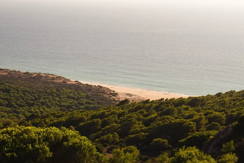
The Costa Brava Coastal Trail is not a single, purpose-built hiking track but rather a historical network of paths that have been meticulously linked and restored to form a continuous long-distance route. The trail primarily follows the GR 92 long-distance path, though the "Camí de Ronda" specifically refers to the sections that hug the shoreline. The experience is defined by its extraordinary geological diversity. In the south, the trail traverses red-hued granite cliffs and golden sand beaches. As you move north through the Baix Empordà, the landscape softens into wetlands and long stretches of dunes, before transforming again into the wild, wind-swept lunar landscape of the Cap de Creus peninsula, where dark schist rock meets the deep blue of the sea.
Walking the Costa Brava is a sensory experience. The air is thick with the scent of "Garriga"—a Mediterranean scrubland composed of wild rosemary, thyme, mastic, and rockrose. The soundscape is dominated by the rhythmic crashing of waves against the rocky shore and the cicadas' drone in the heat of the afternoon. While the trail passes through world-class tourist destinations like Tossa de Mar, Cadaqués, and Calella de Palafrugell, it also provides access to stretches of coastline that remain remarkably wild and undeveloped. These "wild" sections, particularly around the Cap de Begur and the Montgrí Massif, offer a sense of isolation that is rare in Western Europe's coastal regions.
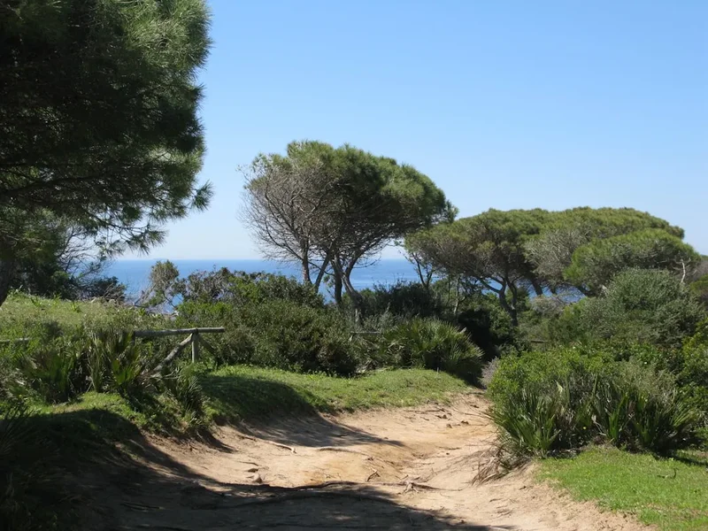
Physically, the trail is more demanding than its "coastal" moniker might suggest. The cumulative elevation gain of 6,000 metres is achieved through hundreds of short, steep climbs. The terrain varies from paved promenades and wooden boardwalks to narrow, technical single-tracks with loose scree and exposed cliff edges. Walkers must be prepared for a "staircase" effect—constantly climbing out of one cove only to descend into the next. However, the reward is the ability to swim in crystal-clear Mediterranean waters at multiple points every single day, making this perhaps the most refreshing long-distance trek in the world.
History and Cultural Context
The name "Camí de Ronda" translates literally to "The Patrol Path." Its origins date back to the 19th century when it was used by local authorities to monitor the coastline. However, its most famous and notorious era was during the mid-20th century, following the Spanish Civil War. During the Francoist period, Spain was subject to international isolation and severe economic hardship, leading to a massive surge in smuggling (contraband). Smugglers would land small boats in the hidden coves of the Costa Brava, carrying highly sought-after goods such as tobacco, coffee, sugar, penicillin, and later, luxury items like nylon stockings and transistor radios.
The Spanish Guardia Civil used these paths to perform "rondas" (patrols), attempting to intercept the smugglers as they moved goods inland. Many of the stone staircases and narrow ledges seen today were either built or reinforced during this time to allow officers to move quickly between lookout points. As Spain's economy modernised and tourism began to boom in the 1960s, the paths lost their strategic importance and fell into disrepair. It was only in the late 20th and early 21st centuries that local councils and the Generalitat de Catalunya recognised the paths' recreational and historical value, investing in the massive restoration project that exists today.
Beyond the smuggling history, the trail is a corridor through time. Walkers pass the ruins of the Iberian settlement at Ullastret (nearby) and the spectacular Greco-Roman ruins at Empúries, where the Phocaeans first landed in the 6th century BC. The trail also passes through the "Dalí Triangle"—the landscape that shaped the surrealist vision of Salvador Dalí. The white-washed village of Cadaqués and the rugged cliffs of Cap de Creus are essentially living canvases, appearing almost exactly as they did in Dalí's most famous paintings. The cultural heritage of the trail is also found in its "Habaneras"—traditional sea shanties brought back by sailors from Cuba in the 19th century, which are still sung in the taverns of Calella de Palafrugell every summer.
Want more background? Read extended notes on history and cultural context → Learn more
Seasonal Highlights and Weather Reality
The Costa Brava enjoys a Mediterranean climate, but its northern location and proximity to the Pyrenees introduce specific weather patterns that hikers must respect. The "Tramuntana"—a fierce, cold north wind—can blow for days at a time, particularly in the northern sections near Cap de Creus. While it clears the sky to a brilliant blue, it can reach speeds of over 100 km/h, making cliff-top walking hazardous.
Spring (April to June): This is arguably the best time to walk. The landscape is vibrant green, wildflowers like the Cistus (rockrose) are in full bloom, and the temperatures are ideal for hiking (18°C to 24°C). The sea is still bracingly cold (around 16°C–18°C), but the trails are relatively quiet compared to the summer months.
Summer (July to August): Hiking during these months is not recommended for the full 200 km route. Temperatures regularly exceed 30°C, and the humidity can make the steep climbs exhausting. Furthermore, the coastal towns are at peak capacity, making accommodation expensive and difficult to find. If you must hike in summer, start at dawn and finish by midday to avoid the peak solar radiation.
Autumn (September to October): The second "golden window" for the trail. The Mediterranean has been warmed all summer and remains a perfect 22°C for swimming. The air temperature drops to a comfortable 20°C–25°C. September can bring occasional "Gota Fría" (heavy autumnal rains), but these are usually short-lived. The light in October is particularly beautiful, taking on a soft, golden quality that is perfect for photography.
Winter (November to March): While the Costa Brava is sunnier than northern Europe, winter can be surprisingly crisp. Daytime temperatures average 12°C–15°C, but nights can drop toward freezing. Many hotels and restaurants in the smaller villages close for the season, requiring more careful logistical planning. However, for a self-sufficient hiker, the solitude of a winter traverse is unparalleled.
Recommended Itinerary
10-Day Costa Brava Coastal Trail Itinerary
Day 1: Blanes to Tossa de Mar
- Distance: 21 km
- Elevation gain: 650 m
- Time: 6–7 hours
- Start at the Sa Palomera rock in Blanes, the symbolic gateway to the Costa Brava
- Pass through the Marimurtra Botanical Gardens (highly recommended detour)
- Traverse the rugged cliffs of the Ardenya Massif
- Arrive in Tossa de Mar, the only remaining fortified medieval town on the Catalan coast
- Key Waypoints: Cala Sant Francesc, Cala Pola, Vila Vella (Tossa)
Day 2: Tossa de Mar to Sant Feliu de Guíxols
- Distance: 21 km
- Elevation gain: 800 m
- Time: 7–8 hours
- One of the most challenging and isolated sections of the trail
- The path winds through dense cork oak and pine forests with constant elevation changes
- Spectacular views from the Ermita de Sant Elm
- Arrive in the historic cork-producing town of Sant Feliu de Guíxols
- Key Waypoints: Cala Giverola, Cala Salionç, Sant Elm viewpoint
Day 3: Sant Feliu de Guíxols to Palamós
- Distance: 18 km
- Elevation gain: 300 m
- Time: 5–6 hours
- A more manicured section passing through the elegant modernist estate of S'Agaró
- Walk along the "Cami de Ronda de S'Agaró," widely considered the most beautiful architectural section
- Pass through the bustling tourist hub of Platja d'Aro
- Arrive in Palamós, famous for its fishing fleet and red prawns
- Key Waypoints: Sant Pol beach, Sa Conca, Cala Belladona, Torre Valentina
Day 4: Palamós to Calella de Palafrugell
- Distance: 12 km
- Elevation gain: 250 m
- Time: 4 hours
- A shorter day allowing for plenty of swimming in the "Golden Mile" of coves
- Pass the pristine Platja de Castell, saved from development by a local referendum
- Explore the ruins of the Iberian settlement at Cala Estreta
- Arrive in the iconic white-washed village of Calella de Palafrugell
- Key Waypoints: Cala S'Alguer (historic fishermen's huts), Cala Estreta, Cap Roig Botanical Gardens
Day 5: Calella de Palafrugell to Begur
- Distance: 15 km
- Elevation gain: 450 m
- Time: 5–6 hours
- Climb to the Sant Sebastià lighthouse for the best panoramic views of the central coast
- Descend into the deep turquoise waters of Tamariu
- A steep inland climb leads to the hilltop town of Begur, topped by a medieval castle
- Key Waypoints: Llafranc, Sant Sebastià Lighthouse, Cala Pedrosa, Tamariu
Day 6: Begur to L'Estartit
- Distance: 20 km
- Elevation gain: 200 m
- Time: 6 hours
- Descend from Begur to the spectacular Sa Riera beach
- A long, flat section across the beach of Pals and the wetlands of the Ter river mouth
- Views of the Medes Islands (a protected marine reserve) dominate the horizon
- Arrive in the diving hub of L'Estartit
- Key Waypoints: Sa Riera, Platja de Pals, Gola del Ter
Day 7: L'Estartit to L'Escala
- Distance: 18 km
- Elevation gain: 550 m
- Time: 6–7 hours
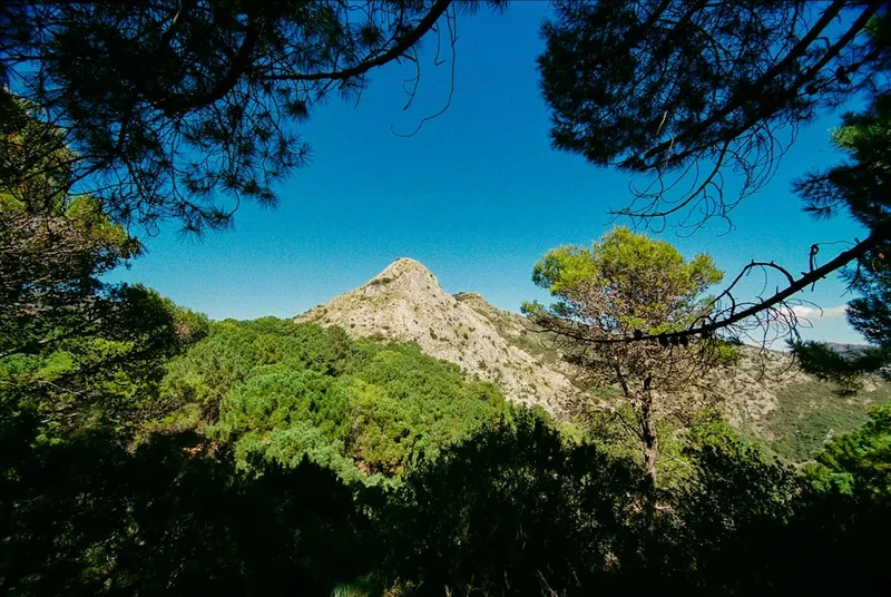
- A wild traverse of the Montgrí Massif, a limestone karst landscape
- The trail is rocky and exposed, with no water sources until the end
- Pass the "Foradada," a massive natural rock arch in the sea
- Arrive in L'Escala, world-renowned for its anchovies
- Key Waypoints: Cap d'Utrera, Cala Montgó, Punta Montgó
Day 8: L'Escala to Roses
- Distance: 25 km
- Elevation gain: 50 m
- Time: 7 hours
- A flat but long day traversing the Gulf of Roses
- Pass the Greco-Roman ruins of Empúries (allow 2 hours for a visit)
- Walk through the Aiguamolls de l'Empordà Natural Park, a haven for birdwatchers
- Arrive in the large bay-side town of Roses
- Key Waypoints: Sant Martí d'Empúries, Castelló d'Empúries (optional detour), Santa Margarida
Day 9: Roses to Cadaqués
- Distance: 22 km
- Elevation gain: 600 m
- Time: 7–8 hours
- Enter the Cap de Creus Natural Park, a landscape of extreme geological beauty
- The path becomes more technical as it winds through hidden coves like Cala Joncols
- Arrive in Cadaqués, the "pearl of the Costa Brava" and former home of Salvador Dalí
- Key Waypoints: Cala Montjoi (site of the former El Bulli restaurant), Cap Norfeu, Cala Jóncols
Day 10: Cadaqués to Portbou
- Distance: 28 km
- Elevation gain: 900 m
- Time: 9–10 hours
- The longest and most physically demanding day, crossing the heart of Cap de Creus
- Visit the Cap de Creus lighthouse, the easternmost point of the Iberian Peninsula
- Pass through the fishing village of El Port de la Selva before the final climb over the mountains to the border
- Finish at the Portbou railway station, overlooking the French border
- Key Waypoints: Port Lligat (Dalí's House), Cap de Creus Lighthouse, El Port de la Selva, Colera
Planning and Bookings
Book Your Trip
Everything you need to plan your journey
Accommodation
Find places to stay near Girona
Flights
Search flights to Girona
Essential Preparation
The Costa Brava Coastal Trail requires a moderate level of fitness. While you are never far from civilisation, the cumulative elevation gain and the technical nature of the rocky paths can be taxing. It is highly recommended to undertake several day hikes with a weighted pack before attempting the full route. Logistics are relatively straightforward as the trail is well-served by public transport. Girona is the primary hub; from Girona-Costa Brava Airport (GRO), you can take a direct bus to Blanes to start the trail. Alternatively, high-speed trains connect Barcelona to Girona in 38 minutes.
If you do not wish to carry a full multi-day pack, several local companies offer luggage transfer services, moving your bags from hotel to hotel while you walk with a daypack. This is a popular option that allows for a more comfortable experience. Booking these services should be done at least one month in advance during the shoulder seasons.
Trail Accommodation
Unlike mountain treks with high-altitude refuges, accommodation on the Costa Brava consists primarily of hotels, hostels, and campsites located within the coastal towns. There is no "official" trail hut system, which gives walkers the flexibility to choose their level of comfort.
Accommodation Types:
- Hotels and Pensions: Available in every town. Prices range from €50 for a basic pension to €200+ for luxury sea-view hotels.
- Hostels (Albergs): Found in larger towns like Blanes, Sant Feliu, and L'Escala. These offer dormitory-style beds for €20–€30 per night.
- Campsites: The Costa Brava has some of Europe's best campsites. Many are located directly on the trail and offer "Glamping" tents or small bungalows if you don't want to carry a tent. Note that many campsites close from November to March.
Booking Requirements:
- Peak Season (July–August): Bookings are essential 4–6 months in advance. Many hotels require minimum stays of 3+ nights.
- Shoulder Season (May, June, September): Bookings are recommended 1–2 months in advance, especially for weekends.
- Wild Camping: Strictly prohibited along the entire coastline and within Natural Parks. Fines are heavy and strictly enforced by the Mossos d'Esquadra (Catalan police).
Required Gear
- Footwear: Trail running shoes or lightweight hiking boots with a high-grip sole (Vibram or similar). The rock is often sharp and abrasive.
- Backpack: 35–45L for a multi-day trip, or 20L if using a luggage transfer service. Ensure it has a ventilated back panel for the Mediterranean heat.
- Navigation: The trail is marked with red and white stripes (GR 92) or green and white stripes (local paths). However, markings can be confusing in towns. An offline GPS map (like AllTrails or Wikiloc) is essential.
- Sun Protection: A wide-brimmed hat, high-quality sunglasses (Category 3 or 4), and a lightweight, long-sleeved sun shirt.
- Clothing: Moisture-wicking synthetic or merino wool layers. Avoid cotton, which stays wet with sweat and causes chafing.
- Rain Gear: A lightweight, breathable waterproof jacket. While rain is infrequent, autumnal storms can be intense.
What to Bring
- Water Capacity: At least 2–3 litres of carrying capacity. While you pass through towns, some sections (like the Montgrí Massif or Cap de Creus) have no water for 15–20 km.
- Swimwear and Microfibre Towel: You will want to swim daily. A lightweight towel is essential for drying off before putting your boots back on.
- Electrolytes: Essential for replacing salts lost through sweat in the humid coastal air.
- First Aid: Focus on blister care (Compeed), antiseptic wipes, and high-factor sunscreen (SPF 50+).
- Snacks: High-energy trail mix, dried fruit, and local "Fuet" (Catalan cured sausage) for quick protein.
- Power Bank: To keep your phone charged for navigation, as GPS drains battery quickly.
- Cash: While cards are widely accepted, some small "Chiringuitos" (beach bars) in remote coves may only take cash.
Permits
One of the greatest advantages of the Costa Brava Coastal Trail is that no permits are required to walk the path. It is a public right-of-way accessible to everyone year-round. There are no entry fees for the Natural Parks (Montgrí, Medes Islands and Baix Ter, or Cap de Creus) through which the trail passes.
Important Considerations:
- Group Sizes: While there is no formal limit for individuals, organised groups of more than 20 people may occasionally require notification to the local town halls if they plan to use specific public facilities.
- Diving and Snorkeling: If you plan to dive in the Medes Islands protected zone, you must book through an authorised diving centre which handles the specific marine park permits.
- Ruins of Empúries: While the trail passes the perimeter, entry to the archaeological site requires a ticket (approximately €7). It is highly recommended to factor this into your Day 8 schedule.
- Dalí House-Museum (Port Lligat): If you wish to visit Dalí's home on Day 10, you must book weeks or even months in advance online. They do not sell tickets at the door, and entry is strictly timed.
Other Activities in the Area
The Costa Brava is a world-class destination for more than just hiking. Consider adding "buffer days" to your itinerary to experience the following:
- The Dalí Triangle: Visit the Dalí Theatre-Museum in Figueres (a short train ride from L'Escala), his house in Port Lligat (Cadaqués), and the Gala Dalí Castle in Púbol.
- Scuba Diving and Snorkeling: The Medes Islands near L'Estartit are one of the most important marine flora and fauna reserves in the Western Mediterranean. The visibility is exceptional, and the marine life (including large groupers and barracuda) is abundant.
- Medieval Village Tour: Take a bus inland from Palamós or Palafrugell to visit the perfectly preserved medieval villages of Pals, Peratallada, and Monells.
- Wine Tasting: The Empordà DO (Denomination of Origin) is famous for its Garnatxa (Grenache) and Carinyena (Carignan) wines. Many vineyards near Roses and Cadaqués offer tours and tastings.
- Sea Kayaking: Rent a kayak in Tamariu or Cadaqués to explore sea caves and coves that are inaccessible even by the coastal trail.
- Girona City: Spend at least one full day in Girona. Walk the medieval walls, explore the Jewish Quarter (one of the best-preserved in Europe), and visit the Cathedral (famous as a filming location for Game of Thrones).
Safety and Conditions
Terrain Hazards: The Camí de Ronda is often narrow and can be slippery, especially after rain or in areas with loose decomposed granite (sauló). Some sections have significant exposure to cliff edges. If you suffer from severe vertigo, some parts of the Tossa to Sant Feliu and the Cap de Creus sections may be challenging. Always stay on the marked path; "shortcuts" often lead to unstable cliff edges.
Heat and Hydration: Heatstroke is the most common medical issue on this trail. The combination of high humidity, physical exertion, and direct sun exposure can be dangerous. Drink at least 3 litres of water per day and use electrolyte replacements. Wear a hat and reapply sunscreen every two hours.
The Tramuntana Wind: This north wind can be violent. If a Tramuntana warning is issued (check the Meteocat website), avoid the exposed cliff sections of Cap de Creus and the Montgrí Massif. The wind can easily knock a person off balance and carries a significant risk of flying debris or falling branches in forested areas.
Emergency Services: The universal emergency number in Spain is 112. Operators usually speak English. Because the trail is often near towns, response times are generally good, but in the wilder sections of Cap de Creus, a helicopter rescue may be required for serious injuries.
Wildlife: Wild boars (senglars) are common in the forests of the Costa Brava. They are generally shy but can be aggressive if they have young or if they have become accustomed to being fed by humans. Never leave food outside your tent or accommodation, and if you encounter one, give it a wide berth and do not make sudden movements.
Side Trips and Points of Interest
The Ruins of Empúries: Located just outside L'Escala, this is one of the most important archaeological sites in Spain. It is the only place on the Iberian Peninsula where the remains of a Greek city (Emporion) and a Roman city (Emporiae) coexist. Walking through the ancient streets where the trail literally skirts the city walls is a highlight of the journey.
Sant Pere de Rodes: On the final day, a significant detour (or a separate day trip) leads up to this 10th-century Benedictine monastery. Perched high in the Verdera mountains, it offers what many consider the single best view in Catalonia, looking down over the Gulf of Lion and the Cap de Creus peninsula.
Cap de Creus Lighthouse: This is the "End of the World" for the Costa Brava. The lighthouse sits in a landscape of tortured rock formations that inspired Dalí's "The Great Masturbator." There is a small restaurant at the lighthouse where you can enjoy a meal while watching the waves crash against the easternmost tip of Spain.
The "Indianos" Houses of Begur: In the 19th century, many locals from Begur emigrated to Cuba to seek their fortune. Those who returned wealthy built magnificent colonial-style mansions known as "Indianos" houses. The town holds an annual "Fira d'Indians" in September, but the architecture can be admired year-round along the trail's inland sections.
Leave No Trace

The Costa Brava is under immense environmental pressure from tourism. As a hiker, you have a responsibility to minimise your impact on this fragile Mediterranean ecosystem. The "Posidonia oceanica" seagrass meadows found just offshore are the "lungs of the Mediterranean" and are vital for water clarity and biodiversity; never throw rubbish into the sea.
Your responsibility as a walker:
- Waste Management: Pack out all trash, including organic waste like orange peels or apple cores, which decompose slowly in the arid coastal soil and can attract invasive species.
- Stay on the Path: The coastal flora, such as the sea thrift and various succulents, is highly adapted to salt and wind but extremely vulnerable to trampling.
- Water Conservation: Catalonia frequently suffers from droughts. Be mindful of your water usage in hotels and campsites.
- Fire Safety: The risk of forest fire is "Extreme" during the summer and autumn. Never light fires, and never discard cigarette butts. A single spark can devastate thousands of hectares of protected forest.
- Respect Marine Life: If snorkeling, do not touch or remove any marine organisms. Avoid using sunscreens containing oxybenzone, which harms coral and seagrass; look for "reef-safe" alternatives.