Corno alle Scale: A Tuscan Ridge Walk
Corno alle Scale, meaning "Stair Horn" in Italian, is a prominent peak in the Tuscan-Emilian Apennines, offering a rewarding day hike with spectacular panoramic views. Situated within the Corno alle Scale Regional Park, this trail is a popular destination for hikers seeking alpine-like scenery without the extreme remoteness of higher mountain ranges. The route typically ascends to the summit of Corno alle Scale (1,945 metres), providing a challenging yet accessible climb that showcases the rugged beauty of the region. The park is known for its diverse flora and fauna, including ancient beech forests, alpine meadows, and a chance to spot wildlife.
- Distance: 15.0 km (return trip)
- Elevation gain: 800 m
- Duration: 6-7 hours
- Difficulty: Moderate
- Best Time: June to September
- Closest City: Bologna
- Trailhead Access: From Bologna, take the A1 motorway towards Florence, exit at Sasso Marconi. Follow signs for Porretta Terme, then Lizzano in Belvedere. Continue to Madonna dell'Acero and Rifugio Cavone. Ample parking available.
- Permits: No permits needed.
Overview
The hike to Corno alle Scale is a classic mountain ascent that offers a taste of high-altitude trekking within the Apennine range. The trail begins from the vicinity of Rifugio Cavone, a well-established starting point with convenient parking and amenities. From here, the path gradually ascends through varied terrain, transitioning from dense woodlands to open alpine meadows as the elevation increases. The route is generally well-marked, though some sections can be steep and rocky, demanding a moderate level of fitness and sure-footedness.
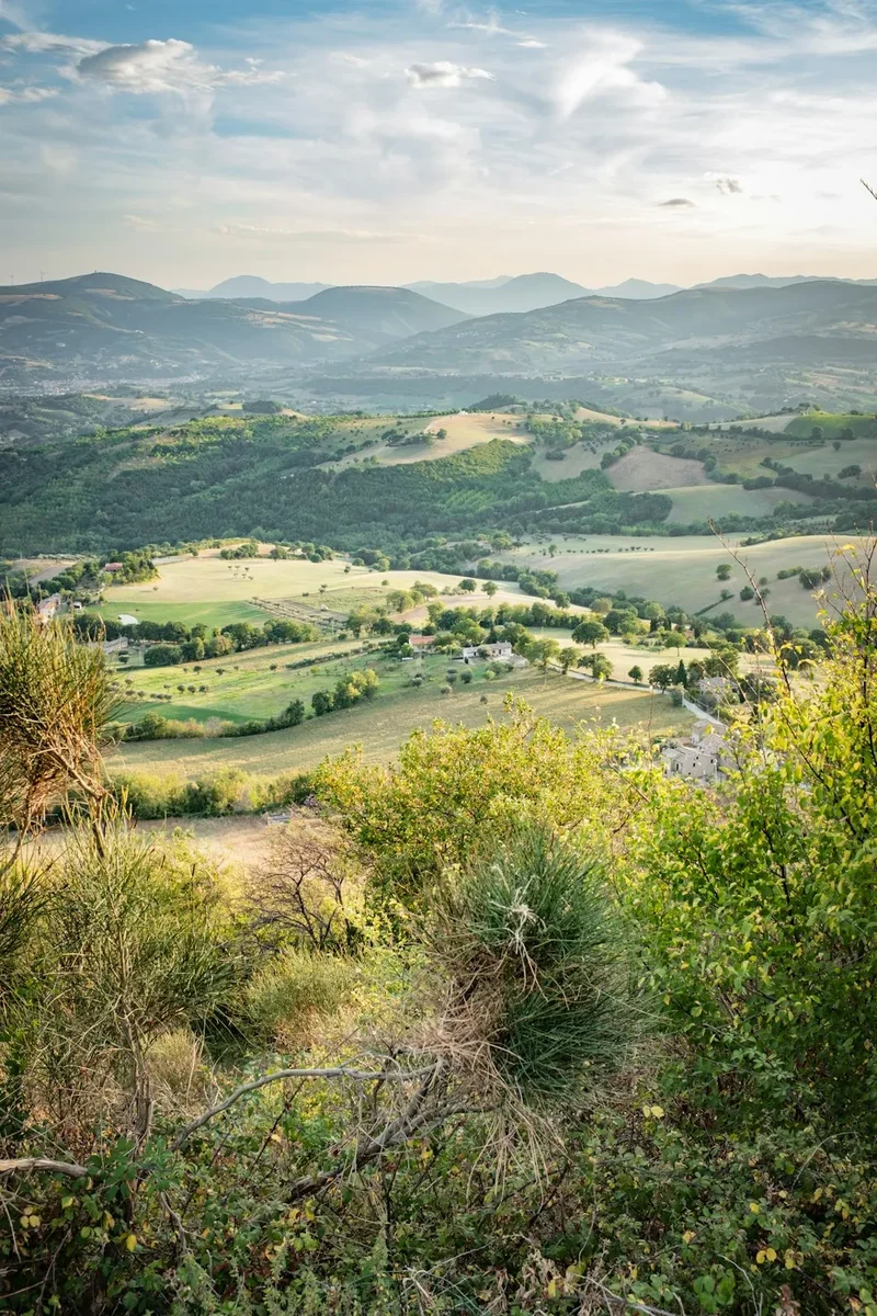
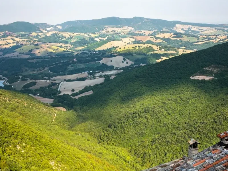
The ascent is characterised by its steady climb, with the landscape opening up to reveal expansive views of the surrounding valleys and peaks. As you approach the summit ridge, the terrain becomes more exposed, offering breathtaking vistas that stretch across Tuscany and Emilia-Romagna. The summit itself is marked by a cross and provides a commanding 360-degree panorama, making the effort of the climb entirely worthwhile. The descent follows a similar path, allowing for a different perspective on the scenery encountered on the way up.
Corno alle Scale is particularly beautiful during the summer months when the alpine meadows are in bloom, and the weather is generally stable. The park's natural beauty, combined with the physical challenge of the hike, makes it a highly recommended day trip for those visiting the region and seeking an active outdoor experience.
History and Cultural Context
The Corno alle Scale region has a long history of human interaction, primarily linked to pastoralism and the exploitation of natural resources. For centuries, these mountains served as grazing grounds for sheep and cattle, with shepherds establishing temporary settlements and trails that have, in some cases, evolved into the hiking paths used today. The name "Corno alle Scale" itself, translating to "Horn of Stairs," likely refers to the distinctive stepped appearance of the mountain's slopes or perhaps to ancient pathways carved into the rock.
The establishment of the Corno alle Scale Regional Park in the late 20th century marked a significant shift towards conservation and the promotion of sustainable tourism. The park aims to protect the unique biodiversity of the Apennine ecosystem, which includes rare plant species and a variety of wildlife such as chamois, deer, and various bird species. The presence of rifugi (mountain huts) like Rifugio Cavone indicates a tradition of hospitality and support for travellers in these mountainous areas, dating back to when these routes were primarily used by shepherds and hunters.
The area also holds cultural significance for the local communities, who have a deep connection to the mountains and their traditions. Festivals, local cuisine, and folklore often reflect the influence of the Apennine landscape. The park's development has helped to preserve this heritage while making the natural beauty accessible to a wider audience, allowing visitors to experience the rugged charm and historical depth of the Tuscan-Emilian Apennines.
Seasonal Highlights and Weather Reality
The best time to hike Corno alle Scale is generally from June to September. During these months, the weather is typically most favourable for high-altitude trekking, with longer daylight hours and a higher probability of clear skies.
Spring (April-May): While the lower slopes may be accessible, higher elevations can still be snow-covered, and trails might be muddy or icy. Wildflowers begin to bloom, offering a beautiful spectacle, but caution is advised due to unpredictable weather and potential snow patches.
Summer (June-September): This is the peak season. The alpine meadows are vibrant with wildflowers, and the weather is generally warm and stable, ideal for the ascent. However, summer afternoons can sometimes bring thunderstorms, so starting early in the day is always recommended. The summit offers expansive views, and the air is crisp and clear.
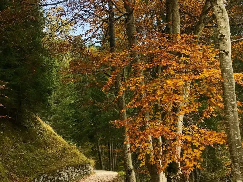
Autumn (October-November): The landscape transforms with stunning autumn colours, particularly in the forested sections. The air becomes cooler, and the crowds thin out. However, the weather can become more unpredictable, with increased chances of rain, fog, and early snowfalls, especially at higher altitudes. Days are shorter, requiring careful planning.
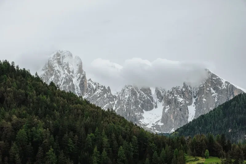
Winter (December-March): Corno alle Scale is a popular destination for winter sports, with ski resorts operating in the vicinity. However, hiking to the summit is generally not recommended for casual walkers due to heavy snow, ice, and extreme cold. Only experienced mountaineers with appropriate winter gear and knowledge should consider attempting the summit during this period.
Weather Reality: Mountain weather can change rapidly at any time of year. Even in summer, conditions at the summit can be significantly colder and windier than at the trailhead. Always check the local weather forecast before setting out and be prepared for a range of conditions, including rain, wind, and temperature drops.
Recommended Itinerary
Corno alle Scale Day Hike Itinerary
Early Morning (Approx. 8:00 AM): Arrival and Preparation
- Arrive at the parking area near Rifugio Cavone (approx. 1,520 m).
- Take time to prepare your gear, check your backpack, and ensure you have sufficient water and snacks.
- Briefly review the trail map and conditions.
- The air is usually cool and crisp at this altitude, offering a refreshing start.
Morning (Approx. 8:30 AM - 12:30 PM): Ascent through Forests and Meadows
- Begin the hike from the vicinity of Rifugio Cavone.
- The initial section of the trail often winds through dense beech forests, providing shade and a pleasant walking experience.
- Follow well-marked paths that gradually gain elevation.
- As you ascend, the forest begins to thin, opening up to alpine meadows dotted with rocks and scattered trees.
- The gradient becomes steeper in sections, requiring a steady pace and good footing.
- Keep an eye out for the diverse flora and fauna of the regional park.
- Pass by smaller streams or rocky outcrops that offer natural resting points.
Midday (Approx. 12:30 PM - 1:30 PM): Reaching the Summit Ridge and Lunch
- The trail emerges onto the exposed summit ridge, offering increasingly dramatic panoramic views.
- The final approach to the summit of Corno alle Scale (1,945 m) is often along a rocky, well-defined path.
- Reach the summit, marked by a cross and a small monument.
- Take ample time to enjoy the 360-degree views, which can extend for many kilometres on a clear day.
- Have your packed lunch and rehydrate while soaking in the accomplishment and the scenery.
- This is an excellent spot for photography.
Afternoon (Approx. 1:30 PM - 4:30 PM): Descent and Return
- Begin the descent, retracing your steps or following a slightly varied route if available and well-marked.
- The descent can be hard on the knees, so take care with your footing, especially on steeper or rockier sections.
- Enjoy the changing perspectives of the landscape as you descend through the meadows and forests.
- The sounds of the forest and the cooler air can be very pleasant on the way down.
- Arrive back at the starting point near Rifugio Cavone.
Late Afternoon (Approx. 4:30 PM onwards): Post-Hike Relaxation
- Option to visit Rifugio Cavone for refreshments or a meal.
- Reflect on the day's hike and the beautiful scenery encountered.
- Prepare for your onward journey.
Important Notes:
- This is a day hike, so no overnight accommodation is required on the trail itself.
- The route is generally well-signposted, but carrying a map and compass or GPS device is always advisable.
- Wear sturdy hiking boots with good ankle support.
- Carry plenty of water (at least 2 litres per person) and high-energy snacks.
- Be prepared for changing weather conditions, even on a clear day.
Planning and Bookings
Book Your Trip
Everything you need to plan your journey
Accommodation
Find places to stay near Bologna
Flights
Search flights to Bologna
Essential Preparation
Corno alle Scale is a popular day hike, and while no specific bookings are required for the trail itself, planning your visit is essential for a safe and enjoyable experience. The closest major city is Bologna, which serves as a convenient base for travellers. From Bologna, you can rent a car or use public transport to reach the trailhead. Driving is the most flexible option, allowing you to depart at your convenience and stop at points of interest along the way.
The journey from Bologna typically involves taking the A1 motorway towards Florence, exiting at Sasso Marconi. From there, follow signs for Porretta Terme and then Lizzano in Belvedere. The final stretch leads to Madonna dell'Acero and the area around Rifugio Cavone, where ample parking is available. The drive from Bologna to the trailhead takes approximately 1.5 to 2 hours, depending on traffic conditions.
It is advisable to check the weather forecast for the specific mountain region before you depart, as conditions can differ significantly from those in the city. Ensure you have all necessary gear, sufficient food and water, and a fully charged mobile phone. Inform someone of your hiking plans, including your intended route and estimated return time.
Trail Accommodation
This is a day hike requiring no overnight accommodation.
Required Gear
- Hiking Boots: Sturdy, waterproof hiking boots with good ankle support are essential for navigating the varied terrain, which includes rocky and potentially uneven paths. Ensure they are well broken-in to prevent blisters.
- Backpack: A comfortable daypack (20-30 litres) is sufficient to carry essentials. Ensure it has a rain cover.
- Clothing: Wear moisture-wicking base layers, an insulating mid-layer (fleece or down jacket), and a waterproof and windproof outer shell. Layers are crucial as mountain temperatures can fluctuate significantly.
- Headwear: A sun hat or cap for protection from the sun, and a warm hat or beanie for cooler temperatures or wind.
- Gloves: Lightweight gloves can be useful for cooler conditions or windy exposed sections.
- Navigation: A physical map of the area, a compass, and/or a GPS device or smartphone with offline maps downloaded. Mobile signal can be unreliable in mountainous areas.
- First-aid kit: A basic kit including plasters, antiseptic wipes, pain relievers, blister treatment, and any personal medications.
- Sun protection: High SPF sunscreen, sunglasses, and lip balm. The sun can be intense at higher altitudes, even on cloudy days.
- Headlamp: A headlamp or torch with spare batteries is essential in case of unexpected delays or if you start/finish in low light conditions.
What to Bring
- Food: High-energy snacks such as nuts, dried fruit, energy bars, and sandwiches for lunch. Pack more than you think you'll need.
- Water: At least 2 litres of water per person. Water sources may be available, but it is advisable to carry sufficient water or a reliable water filter/purification tablets.
- Toiletries: Biodegradable toilet paper, hand sanitiser, and any personal hygiene items. Pack out all waste.
- Trekking poles: Optional but highly recommended, especially for the ascent and descent, as they can reduce strain on knees and improve balance.
- Camera: To capture the stunning scenery.
- Whistle: For emergency signalling.
- Small knife or multi-tool: Useful for various small tasks.
Permits
No specific permits are required to hike to Corno alle Scale. The trails are part of the public access network within the Corno alle Scale Regional Park. However, it is always good practice to be aware of any park regulations or advisories that may be in place, especially concerning fire restrictions or temporary closures due to weather or maintenance.
The park is managed to ensure the preservation of its natural environment and to provide safe recreational opportunities. While no fees are levied for general access, visitors are expected to adhere to principles of responsible outdoor recreation, such as staying on marked trails and packing out all litter.
For any specific information regarding park access or conditions, it is advisable to consult local tourist information offices or the official website for the Corno alle Scale Regional Park, if available. Generally, the accessibility of this trail makes it a straightforward destination for a day trip without the need for advance booking or permit acquisition.
Other Activities in the Area
The Corno alle Scale Regional Park and its surroundings offer a variety of activities for visitors:
- Skiing and Snowboarding: During winter months, the area is a popular ski resort, with slopes catering to various skill levels.
- Nature Photography: The diverse landscapes, from dense forests to open alpine meadows and dramatic peaks, provide excellent opportunities for photography throughout the year.
- Wildlife Spotting: The park is home to a range of wildlife, including chamois, deer, foxes, and various bird species. Early mornings and late afternoons are often the best times for spotting animals.
- Mountain Biking: Designated trails within or near the park may be suitable for mountain biking, offering a different way to explore the terrain.
- Visiting Local Villages: Explore charming nearby villages such as Lizzano in Belvedere or Porretta Terme, known for their thermal baths and local cuisine.
- Culinary Experiences: Sample regional specialities in local trattorias and restaurants, focusing on fresh, seasonal ingredients from the Emilia-Romagna and Tuscan regions.
- Relaxation at Rifugi: Enjoy the hospitality of mountain huts like Rifugio Cavone, which often serve traditional food and drinks, providing a perfect spot to rest and refuel.
Safety and Conditions
Weather Preparedness: Mountain weather is notoriously unpredictable. Always check the forecast from a reliable source (e.g., MetService or local Italian meteorological services) before and during your hike. Be prepared for sudden changes in temperature, wind, rain, or even snow, especially at higher altitudes. Hypothermia is a risk even in summer if you get wet and cold.
Trail Conditions: The trail to Corno alle Scale is generally well-maintained but can be steep and rocky in places. Ensure you have appropriate footwear with good grip. In spring or after heavy rain, sections of the trail may be muddy or slippery. In winter, snow and ice can make the trail impassable without specialised equipment.
Navigation: While the main trail is usually well-marked, it is crucial to carry a map and compass or a GPS device. Do not rely solely on mobile phone navigation, as signal can be intermittent. Familiarise yourself with the route before you start.
Water and Food: Carry sufficient water (at least 2 litres per person) and high-energy food. There may be limited opportunities to refill water bottles or purchase food on the trail, especially outside of peak season or if rifugi are closed.
Physical Fitness: The hike involves a significant elevation gain (800 m) and a moderate difficulty level. Ensure you are physically fit enough for a 6-7 hour hike with sustained uphill and downhill sections. Pace yourself and take breaks as needed.
Emergency: Know the emergency contact numbers for the region (112 is the European emergency number). Inform someone of your hiking plans, including your route and expected return time. Consider carrying a personal locator beacon (PLB) if hiking in remote areas or during less busy periods.
Wildlife: While generally not aggressive, be aware of local wildlife. Maintain a safe distance and do not feed animals. Be cautious of potential hazards like uneven ground or loose rocks.
Side Trips and Points of Interest
Rifugio Cavone: Located near the trailhead, this mountain hut is a convenient starting and ending point. It often serves as a place to rest, enjoy refreshments, and soak in the mountain atmosphere before or after your hike. It represents the traditional hospitality of the Apennine region.
Madonna dell'Acero Sanctuary: A short distance from Rifugio Cavone, this small sanctuary is a place of pilgrimage and offers a peaceful spot for reflection. It is often associated with local legends and traditions, adding a cultural dimension to the start of your hike.
Alpine Meadows: As you ascend, the landscape transitions from dense forests to open alpine meadows. These meadows are particularly beautiful in late spring and summer when they are carpeted with wildflowers. They offer a stark contrast to the forested lower slopes and provide excellent opportunities for photography and wildlife spotting.
Summit Cross and Monument: The summit of Corno alle Scale is marked by a prominent cross and often a small monument or cairn. This is the focal point of the hike, offering a sense of achievement and providing the most expansive panoramic views of the surrounding Apennine range.
Panoramic Viewpoints: Throughout the ascent and descent, numerous points along the trail offer breathtaking vistas. These viewpoints are ideal for short breaks, allowing you to appreciate the scale of the landscape and the changing light on the mountains.
Leave No Trace
The Corno alle Scale Regional Park is a precious natural environment, and it is vital that all visitors practice Leave No Trace principles to preserve its beauty and ecological integrity for future generations. By following these guidelines, you help minimise your impact and ensure the park remains a pristine destination.
Plan Ahead and Prepare: Research the trail, understand its difficulty, and check the weather forecast. Pack appropriate gear and sufficient food and water. Inform someone of your plans.
Travel and Camp on Durable Surfaces: Stick to marked trails. Avoid walking on fragile vegetation, especially in alpine meadows, as it can take years to recover. The established paths are designed to withstand foot traffic.
Dispose of Waste Properly: Pack out everything you pack in, including all food scraps, wrappers, and any other litter. Use designated toilet facilities where available, or if not, dig a cathole at least 60 metres away from water sources, trails, and campsites, and bury human waste. Pack out used toilet paper.
Leave What You Find: Do not remove or disturb natural objects such as rocks, plants, or flowers. Take only photographs and memories.
Minimise Campfire Impacts: Campfires are generally not permitted on day hikes and are highly discouraged in natural areas. If permitted in designated areas, use existing fire rings and ensure fires are completely extinguished.
Respect Wildlife: Observe wildlife from a distance. Never feed animals, as it can disrupt their natural behaviours and diets, and can be harmful to their health. Secure your food to prevent attracting animals.
Be Considerate of Other Visitors: Keep noise levels down and yield to other hikers on the trail. Respect the experience of others seeking solitude and enjoyment of nature.